Outdoor Links
Hike Arizona
Trip Planning Guide
Trip Report Index
Calendar of Events
Library
|
Fossil Springs Day Hike Strawberry November 14, 2015 by Dave French |
|
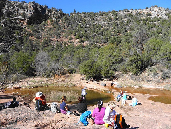
 Trailblazers set out for Fossil Springs. [photo by John] |
| Standing: John, Dottie, Jim, Rebecca, Carol, Funyung, Nancy, Jessica, Tamar, Michael, Kim Z, Dave, Alice, Arturo | Kneeling: Kim B, Monika H., Lin. |
|
Sixteen trailblazers and guests met in Fountain Hills at 7:00 AM, loaded into 4 cars and headed north on SR 87. We stopped at the Carl’s Jr on the NE corner of SR 260 in Payson instead of the overcrowded Mickey D’s on the SE corner. Worked out very well. We continued to Strawberry where we met one other hiker and proceeded down Fossil Creek Road to the trailhead. |
|
Things have changed somewhat. I was told we had about 4 miles of unpaved road and that the trailhead is at the end of the road (where the NFS blocked it off). Well, now there is less than a mile of unpaved road to the turn off to the trailhead and the road continues at least another half mile. |
 You had better pay attention! [photo by John] |
|
We went through the usual of getting our gear on and plenty of warm clothes because it was about 40 degrees, but bright sunshine and little wind. After the group picture and introductions, we headed down the trail. There were numerous huge signs cautioning hikers to take plenty of water because there are usually 200 rescues in the canyon each year. I can imagine that in the hot part of the year, this can be a hot hike. But today, some hikers had gloves and coats with hoods at least at the start of the hike. The trail was largely in shade or filtered sunlight due to the low angle of the sun. In the middle of the year, there is probably not a lot of shade. |
 Yes, we’re going all the way down there. [photo by Dave] |
 We can figure this out. [photo by Lin] |
 Fall color in the canyon. [photo by John] |
 Fall color. [photo by Lin] |
 Frost on the trail. Watch your step. Brrrrr! [photo by Lin] |
|
The trail drops quickly into the canyon with great views down the heavily forested canyon and the rock outcroppings at the rim. It took about two hours to reach Fossil Creek, a distance of about 4 miles. We stopped at a large outcropping of sandstone that provided good seating and ate our lunch snacks. From here, Michael took over to lead the group to the other interesting features in the canyon. The map available from the NFS just shows the trail going to the creek but not crossing it. Michael had been there before and lead us across the creek on the sandstone outcropping and down a trail on the west side of the creek. A trail branches off to the left where there is a trail sign pointing straight ahead. We took the unmarked trail down toward the creek. That trail became quite narrow with heavy brush and trees but led us to the famed Fossil Springs. It is an amazing source of water bubbling up like some of the things you see in Yellowstone National Park. The spring water was tepid temperature. From that point on Fossil Creek is more like a river. |
 Hikers relax at the first stream crossing. [photo by Dave] |
 Fossil Creek. [photo by Lin] |
 Cascade on Fossil Creek. [photo by Dave] |
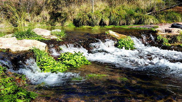 Cascade on Fossil Creek. [photo by Lin] |
 Water bubbles up at the spring. [photo by John] |
|
We backtracked to the trail along the west side and continued down creek for a short distance and then another left to the “main pool” with a small cascade in the river. We then continued for another quarter of a mile or so to the old dam site which is now a substantial waterfall. The NFS map says the Fossil Springs hike does not provide access to the waterfalls. But this waterfall is much higher than the ones a few miles downstream that are accessible from the Camp Verde side, however, it does not provide a good swimming hole. We explored around the dam site area to find remnants of buildings and walls and a dump of old cans all left by the dam operators. We spent about an hour in the bottom of the canyon from the time we first encountered the stream to when we began the climb out. It was such a nice day and by that time a very pleasant temperature, it was easy to just linger. |
 The main pool is full of life. [photo by Lin] |
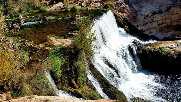 Waterfall at old dam site. [photo by Lin] |
 View from below the waterfall. [photo by Funyung] |
 Remains of a building for the dam operators. [photo by Dave] |
 Dottie explores the wall. [photo by Dave] |
 A rather odd camping shelter. [photo by Dave] |
 Trailblazers enjoy a picnic on the rocks. [photo by John] |
 Aw, you mean we have to walk back? [photo by John] |
|
The climb out was easier that I had expected. I had always heard this is a tough hike, and I suspect that in hot weather it can be much more difficult. We all made it out in about two and a half hours. The total hike time was 5.5 hours and we covered 9 miles. |
 T.H.A.T. Brewery in Pine. [photo by Dave] |
|
Thirteen of hikers stopped in Pine at T.H.A.T. Brewery for eats and drinks. The restaurant was very accommodating and set up the table quickly and even provided free hot snacks for us as we waiting for our food. |
 Top of Page
Arizona Trailblazers Hiking Club, Phoenix, Arizona
Comments? Send them to the AZHC .
updated May 25, 2020