Outdoor Links
Hike Arizona
Trip Planning Guide
Trip Report Index
Calendar of Events
Library
|
Johnson Canyon Railway Tunnel Williams July 11, 2015 by Scott Green |
|
 No train today. [photo by Bill] |
| Andy, Diana, Biljana, Dave, Bill, Steve, Jim, Sana, Ken, Jazmin, Scott, Rudy, Michael |
|
It was a walk-in-the-park; or for this club outing it was more like a historical stroll. No dramatic elevation changes. No long distances. Perfect weather of small fluffy white clouds with no threat of rain and a medium breeze with a temperature which was neither hot or cool. It was a historical stroll to experience the era of the late 1800s and early 1900s. |
 A young man stands next to a new train track at Johnson Canyon near Ash Fork. |
|
Once we gathered at our usual I-17 car-pool collection spot, the 13 of us (Ken, welcome to the club!) automatically, as we do most every summer weekend, drove north on the freeway and uphill to Flagstaff. This trip was a little unique because just south of Flagstaff at the I-40 interchange we made a 45 degree turn to the west and went back down the hill some 47 miles past Williams to Welch Road, Exit 151. Welch Road was our interstate exit from the present day to the past. |
 Listen up! We’re going this way. [photo by Dave] |
|
About 3 miles away was our first stop, Welch Station. To reach our first stop, the vehicles had to traverse a rocky creek which, due to seasonal rains over many weeks, was muddy and had the potential to sink and capture one of the vehicles. To be prudent, the vehicle was parked and it occupants transferred to a 4X4 to be ferried and taken the final distance. Once we arrived at the spot of Welch Station, it wasn’t until we walked around and explored that the group realized its historical significance. We had arrived where Welch Station once operated as a train signaling and tracking station during WWII and earlier. The station was a precursor to the current electronic pole ‘flags’ to indicate go, slow, or stop. Like the remaining aspects of our day’s journeys, there is much more to read via web searches to better understand and appreciate what we explored and saw. Since Welch Station was built for the railroad, there was, to no one’s surprise, the remnants of the old railroad bed without its steel rails and wooden ties. Due to modern locomotive efficiency, the main track was moved north many years ago. Our next stop lay to the east about 2.5 miles along the railroad bed. We started as a group and began our historical stroll up the gentle grade which paralleled the upstream direction of Johnson Canyon. As expected, the railroad bed, now a walkway, took us through rock cutouts and engineered fill so there were none of the traditional hiking ups and downs. We did notice as we gained distance, the dramatic narrowing and depth of the canyon. As if we were on a moving train, we looked up the missing train tracks to see the curves and bends ahead. |

|

|
| Rails to Trails. [photos by Bill] | |
|
As we neared the 2.5 miles, our next historical destination was ahead. As the only one between Los Angeles and Flagstaff, up ahead was the difficult to build but absolutely necessary 1882 Johnson Canyon Tunnel. Through its years of use, the tunnel was infamous for its fire and reconstructions requiring steel plates to be attached to its peaked ceiling and concrete retaining walls, dated 1921. Due to the critical nature of the rail line and tunnel, during WWII guards were stationed as a precaution. Just before the tunnel was once a wooden trestle, which was eventually filled in with ground material mined from the nearby hills. We explored both ends of the tunnel, knowing that the rail bed continued east to Williams and Flagstaff. When our exploration was satisfied, we returned the way we came, to Welch Station. A few of us continued about 200 yards west and found the existing rail tracks which run from Williams to Ash Fork, south toward the Prescott area, and eventually to Wickenburg, Sun City, Grand Ave, and into Phoenix. Although not as heavily used as the transcontinental route, this path allows freight to move between the transcontinental route and Phoenix. |
 Let’s dig those rocks. [photo by Bill] |
 Bill serves as mine inspector. [photo by Bill] |
 Approach to the tunnel. [photo by Dave] |
 Johnson Canyon Railway Tunnel. |
 Diana, Jazmin, and Sana, from the top. [photo by Dave] |
 And I’ll huff and I’ll puff and I’ll pull the train for you. |

|

|
| There’s light at the end of the tunnel. | |
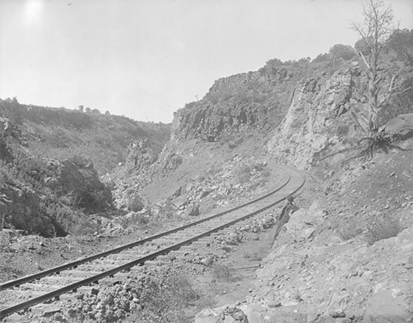
 The tunnel goes under some rough country. [photo by Dave] |
|
By this time, we 13 had collected once again at Welch Station, had a little to eat, and were ready for our next point of interest. About 0.5 miles, if that, down the road and just a few yards off we found the Johnson Crater. Although formally called a crater, perhaps it is a sink hole. Its origin isn’t fully known but it is none the less dramatic in its circumference and depth. After the group split to walk around it clockwise and counter-clockwise, we easily walked back to Welch Station and the vehicles. At this point of our day, we had completed 4 out of 5 planned objectives: Welch Station, Johnson Tunnel, the existing railroad and Johnson Crater. One more to go — well, actually three more remained. |
 Well-maintained tracks of the BNSF. [photo by Dave] |
 Johnson Crater. But what is it? [photo by Bill] |
 Side view of the Johnson Crater. [photo by Dave] |
|
Getting back into the vehicles we drove to our final destination, which took us to two other points of interest along the way. Fortunately, the path to the final destination required us to drive 3 miles on the original pavement of US66, aka Route 66. At least one member of the club reminisced about their grandparents completing a journey from Chicago to Los Angles during the summer, wearing their finest wool suits, without air-conditioning, and debating whether the interior temperature was more bearable with the windows up or down!! The narrowness of the two lane road was noticeable as we passed over the concrete culverts. |

|

|
| We found the historic Route 66. [photos by Dave] | |
|
We parked along US66, which no longer had two way traffic due to a locked gate down the road, and headed as a group to one of two lakes. Reminder: with 99% certainty, every lake as has an associated dam. The first visited lake and dam was newer than its sister closely downstream, this first dam was built in 1911, one year before Arizona became the last contiguous 48th state of the union. The dam is aptly named due to its quarried sandstone construction: the Stone Dam. Our final destination for the day lay just down steam but without any formal walking path. This required a GPS map, a little rocky walking, and a lot of faith that the pied piper knew where he was headed. After a walk along the ridge between the flat top and the slope toward the creek, we made a 45 degree turn downhill along an abandoned fence post line to where we were able to see the lake side of our final historical spot: the 1897 Ashfork-Bainbridge Steel Dam. |
 The Stone Dam is aptly named for its quarried sandstone construction. |
 The 1897 Ashfork-Bainbridge Steel Dam. [photo by Dave] |
 Steel Dam, downstream. [photo by Dave] |
|
Oh, but absolutely this is not your normal run-of-the-mill 1897 steel dam! This is the first large steel dam in the world and is included in the National Register of Historic Places. It is one of only two other build steel dams in the US and the other two are no longer standing. Why steel? Because at the time of construction, a steel dam was significantly cheaper to build than masonry structures, although no steel dams have been built in the US since 1911. Taking a shorter, more direct route, we ended our historical day and headed back to the parked cars. So where to go for our traditional end-of-day meal? Really, there was only one answer: a Route 66 meal in Ash Fork at their “French” restaurant, The Café. We were warmly welcomed and consumed copious drinks, along with American meals of burgers/fries, chicken fried steak, and green Chile burros. Thanks to all for very enjoyable historical stroll. |
|
Supplemental Report by Jim Buyens |
|||||||||||||||||||||||||||||||||||||||||||||||||
|
Thanks, everyone, for joining this hike and especially to you, Scott, for being such an excellent leader. I don’t believe I’ve ever been on a hike with that many historic points of interest. It was great. Scott and I discussed the total distance to be recorded, including the crater, the two dams, and Route 66, and decided the total distance was probably 8 miles. But if anyone has a more accurate number, please speak up. I only recorded stats for the hike out to the tunnel and back. Jim |
|||||||||||||||||||||||||||||||||||||||||||||||||
|

|
||||||||||||||||||||||||||||||||||||||||||||||||
| → More pictures and commentary, by Jim. | |||||||||||||||||||||||||||||||||||||||||||||||||
| → More pictures, by Dave. | |||||||||||||||||||||||||||||||||||||||||||||||||
 Top of Page
Arizona Trailblazers Hiking Club, Phoenix, Arizona
Comments? Send them to the AZHC .
updated September 18, 2022