Outdoor Links
Hike Arizona
Trip Planning Guide
Trip Report Index
Calendar of Events
Library
The Magnificent Grand Canyon of Arizona
on a Rim-to-Rim Journey Through Time
October 5-10, 2001
by Chuck Parsons
 View from the North Rim near the North Rim Lodge. Standing at the rim of this vast and seemingly infinite chasm carved deeply into the earth’s crust, one is both awe-struck and deeply humbled by the sheer size and overwhelming magnificence of what is almost beyond the reach of human imagination. The most eloquent words ever written or the most breathtaking pictures ever taken can only marginally begin to describe what this, one of the Seven Natural Wonders of the World, is really all about. |
 Kathy, Tim, Tom, Chuck, and Mike at the North Kaibab Trailhead |
The Grand Canyon is simply one of those things in life that one must see and experience for one’s self to even begin to appreciate and understand what it is all about. Better yet, is to take several days and walk down into the unseen depths of the canyon, all the way to the river that carved its way down to the canyon floor, and to be totally and completely surrounded and enveloped by it, to take it in with all of one’s senses. |
|
On this spectacular Saturday morning, five members of the Motorola Hiking Club are about to embark on just such a journey of discovery and self-renewal, as we gather at the North Rim, ready to begin our descent on the North Kaibab Trail and enter into the magical realm and hidden worlds of the Grand Canyon. For the next few days we will be living in a different world, a world ruled by the laws and forces of nature, a world as rugged and stark, as isolated and beautiful as can be found anywhere on Earth, a world that will quite literally overwhelm our senses and humble us beyond our imagination. Let us begin our journey through time and experience the world of the Grand Canyon of Arizona, as relatively few are able to see it. |
 The Transept from the North Kaibab Trail |
It is a rather long trip from the Phoenix area to the North Rim, and we had taken the better part of Friday just getting there. Mike Wargel (our intrepid hike leader for this event), Scott King (our designated van driver), Kathy Robertson, Tim McAlpin, and I met at Tom Van Lew’s house at 6:30 AM for the start of our long journey to the Grand Canyon’s North Rim. |
|
Angela Lien was to join us, but she unfortunately had to cancel at the last minute because of personal problems. We ran into a minor glitch from the start with Scott’s motorcycle, which had a steering and/or wheel balance problem, which forced him to leave it behind at Tom’s house and drive up with me. After loading our backpacks into the back of Tom’s pickup and kissing Jeannie Van Lew goodbye (oops – that is, Tom kissing Jeannie goodbye), we caravan in three vehicles, bound for Flagstaff, where we would pick up our van that would take us to the North Rim. Arriving in Flagstaff, we encountered another glitch in the form of a defective tire on Tom’s truck. (Sure hope these problems are not an omen of things to come on this trip). Luckily, he caught it before we hit the long road out of town, and we were able to take care of it at a local tire store. We grabbed some lunch while waiting for repairs and then dropped my truck off at Adrienne Van Lew’s apartment in Flagstaff, where she attends NAU. This would serve as Scott’s return vehicle to Phoenix, when he would bring the van back to Flagstaff on Saturday afternoon, after dropping us off at the North Kaibab Trailhead. Scott was originally scheduled to go on this backpacking trip as well, but later decided to bow out, since he was leading another hike into the canyon on the following week. |
 Tom and Mike, one switchback below. |
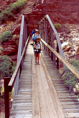
Finally arriving at the Grand Canyon’s South Rim about mid-afternoon, we drove to the Backcountry Office parking area, where we parked Tom’s and Tim’s vehicles and transferred all of our gear and ourselves over to the van for the last leg of our journey to the North Rim. Late in the afternoon we arrived at Marble Canyon, where we would catch our first glimpse of the mighty Colorado River, just a few miles down stream from Lees Ferry. Lees Ferry is only a few miles below Glen Canyon Dam, which now regulates the flow of water through the Grand Canyon. Stopping here for a well-deserved rest break, we got out to stretch our legs and walk across the original bridge that first spanned the river and now serves as a footbridge (a nearby second bridge now carries vehicle traffic across the river). About mid-way across the bridge we are looking directly down into the dark green, swirling waters of the Colorado River, flowing a couple of hundred feet below us on its journey to the east end of the Grand Canyon. |
|
Moving along, we are now enjoying an expansive view of the colorful Vermilion Cliffs to the west before steadily gaining elevation, as we start to enter the heavily wooded Kaibab National Forest and pass through Jacob Lake. After another ten miles the forest abruptly comes to an end, and we are traversing the high Colorado Plateau, as we drop in elevation on our way to our home for the night in Fredonia, just south of the Utah border and its sister city of Kanab. It is now nightfall, as we finally arrive at our accommodations at a place with the unlikely name of Crazy Jug’s. After checking in and getting a bonus room in the process, we quickly head over to Crazy Jug’s Restaurant, where we would probably enjoy our last really good meal for the next five days. Retiring to our rooms after dinner and conversation, we determined to get a good night’s rest for the next day’s 7.5-mile trek into the depths of the Grand Canyon. We awoke bright and early to partly cloudy skies and surprisingly warm temperatures in the mid-fifties, loaded up the van, and made our way back to Jacob Lake and a last hearty breakfast, before heading into the canyon. Making our way south out of Jacob Lake to the North Rim, we are treated to beautiful stands of golden Aspen, many at the peak of their color. We also catch sight of a number of Kaibab mule deer in the meadows as we journey along. Further down the road, we catch a really rare glimpse of a flock of eight wild turkeys foraging for their morning breakfast. This is a sight you don’t see every day in Arizona. We soon pass the turn off for our trailhead, as we make our way to the North Rim Visitor Center. Here we will pick up some trail information, talk to the rangers, and study an interesting 3-D model of the canyon, which paints a pretty realistic picture of just what we are getting ourselves into on this journey to the bottom of the Grand Canyon. Last chance to back out. Anyone?? Nope – we are all determined to do this now. |
|
We decide while we are here to take the extra time and explore at least one of the lookout points and choose the closest one near the visitor center, Bright Angel Point. Although the lookout points on the North Rim are fewer in number than those on the South Rim, they are even more spectacular since, at 8,200 feet, we are a full thousand feet higher on this side of the canyon. We are certainly not disappointed, as our winding trail takes us along breathtaking and panoramic vistas of Roaring Springs and Bright Angel Canyons, where we would soon be hiking, and a large arm of the canyon known as The Transept. Parts of these canyons are literally ablaze with a riot of fall colors, as aspen, maple, alder, and oak put on their annual fall show for us. Our timing couldn’t be more perfect, and this setting is nothing short of surreal. After soaking in these fantastic views and taking a number of pictures, we all meet back at the beautiful Grand Canyon Lodge, perched right at rim’s edge. After checking out the lodge and getting a few more group pictures, we all pile back in the van one last time for the short trip back to our trailhead. |
 Waterfalls along Bright Angel Creek |
|
After Scott parks our van in the trailhead parking lot, we get all of our gear out of the van and set it on the ground, making final checks and adjustments to our backpacks that we would be carrying for the next five days through the canyon. Comparing backpack weights, mine actually comes in heaviest at close to sixty pounds with water. This is not an enviable record, however, and I am not exactly thrilled to be the heavy weight in this category. It turns out that Kathy actually has the record in terms of percentage of body weight, with a 38-pound pack on her 100-pound frame. I watch as she gets her pack on with Tim’s help and catch the grimaced look on her face, as she feels the full weight of the pack settling on her back. I am not in much better shape with my load and wonder now if I really want to go through with this. This is, after all, the final chance to turn back and return to Flagstaff with Scott, before we lose our transportation and last link back to civilization. Absolutely the last call. Anyone? Guess not. What the hell – let’s do it! We are all now fully loaded up, looking and feeling a bit like two-legged mules, as we stagger our way – feeling the full weight of our backpacks for the first time – to the North Kaibab Trailhead with Scott, where he will take group shots of us with everyone’s cameras. This is, after all, a truly momentous occasion, something the average person will probably never do (and something some of us may now be wondering if we should really do). Scott decides he will keep us company for a while longer and hike down the trail with us for a short distance. It is now precisely 11:00 AM and a cool and cloudy 67 degrees, as we start our descent from 8,250 feet into this great chasm we call the Grand Canyon. Our destination is Cottonwood Campground, 7.5 miles and 4,170 below us in the mysterious and unseen depths of Bright Angel Canyon. |
 Kathy and Tim at the first footbridge. |
Before we can reach Bright Angel Canyon, however, we must traverse this steepest section of the North Kaibab Trail, where we will be dropping 3,400 vertical feet in 4.7 miles through Roaring Springs Canyon. On our 14.5-mile journey to the Colorado River we will be passing through four of the seven major life zones of North America and 21 sedimentary rock layers, from the upper Kaibab Limestone layer to the lower Vishnu Schist layer, that together record nearly two billion years of Earth’s history, all written in the rock wall layers of the Grand Canyon. These ancient rock layers record the advance and retreat of seven seas and two major periods of mountain building that lifted the Colorado Plateau to its mile high altitude of today. Some three to six million years ago the Colorado River began performing its manifest destiny of cutting its way down through these layers, and with that, we will conclude Geology 101 for now. |
| “The landscape everywhere, away from the river, is of rock – cliffs of rock, tables of rock, plateaus of rock, terraces of rock, crags of rock – ten thousand strangely carved forms; rocks everywhere, and no vegetation, no soil, no sand. One must think of a whole land of naked rock, with giant forms carved on it: cathedral-shaped buttes, towering hundreds or thousands of feet, cliffs that cannot be scaled, and canyon walls that shrink the river into insignificance, with vast, hollow domes and tall pinnacles and shafts set on the verge overhead; and all highly colored – buff, gray, red, brown, and chocolate...” |
| Major John Wesley Powell, Exploration Of The Colorado River And Its Canyons. |
|
About a half mile below the trailhead, Scott King decides to part company with us and make his way back for the return trip to Flagstaff. We thank him once again for volunteering for van driver duty and wish him a safe trip home. We would hear his voice once again about twenty minutes later over our Motorola TalkAbouts, as he was pulling away from the parking lot. Unbelievably, a little over a mile down the trail, Mike Wargel’s voice comes over the TalkAbouts, announcing that he and Tom were encountering a rain shower. Mike and Tom had quickly taken the lead on this hike and would not relinquish that position for the next five days. Kathy and Tim hiked as a pair most of the time and would play trail tag with me, as we passed one another up from time to time. Within minutes, the rain shower reached me, as I was hiking alone, and I sought shelter under the branches of a large Ponderosa Pine at trail’s edge. The shower was quite refreshing, cooling down the unseasonably warm air along this stretch of the trail. The rain did not last too long, before the sun came out once again to play tag with large fluffy white cumulus clouds drifting along in the bright blue Arizona sky of this beautiful October day. About three miles down the North Kaibab, we all rejoined at the only water stop until Cottonwood for a lunch and rest break. Kathy had some hot spots on her feet that she had to attend to, while Mike and Tom had their boots off to cool their overheated feet, as they munched down some lunch. Replenishing our water supplies, we slowly make our way down the trail to our next stop at Roaring Springs, a little over 1.5 miles away. Roaring Springs, at 4.7 miles from the North Kaibab Trailhead, lies near the confluence of Roaring Springs and Bright Angel Canyons. We stop only briefly to admire and photograph the springs gently cascading in a long series of waterfalls down the hillside opposite our trail, since it is getting late in the day, and we need to reach our campground before dark. This is a vital and constant water source that supplies much of the water for both rims of the canyon, as well as Phantom Ranch and Bright Angel Campground. The nearby Roaring Springs Pumphouse sends this water out to its various destinations via a complex network of pipes. The winds are now picking up speed, and the skies are an omnibus and threatening gray, as a storm system is rapidly sweeping up Bright Angel Canyon in our direction. We now make haste to reach Cottonwood Campground and set up camp, before the skies open up on us. Even Bright Angel Creek, which will parallel our trail and accompany us all the way to the Colorado River now, seems to be speeding up its flow to match our pace, as we hasten to reach our campsite for the night. Soon, in the distance we catch glimpse of the large, towering Cottonwoods that protect and shelter Cottonwood Campground. Mike and Tom, of course, were already settling in and setting up camp, before Kathy, Tim, and I eventually arrived. |
 Ribbon Falls The two are good friends, and both are physical therapists in the middle of their internships, Jason interning at Chinle on the Navajo Reservation, and Brian interning on the Zuni Reservation in New Mexico. They were doing a rim-to-rim hike, making their way from the South Rim this morning to the North Rim, before deciding to call it a day and hoping to find a campsite for the night without permits. Since we had a permit for eight and a party of only five, they were in luck when they found us. It was now pitch dark, and the rain was falling persistently, as we make a decision to turn in early (jeez—it’s only 7:30!) and get a long, long night’s rest before the last leg of our journey to Bright Angel Campground and the Colorado River, another seven miles down the trail through Bright Angel Canyon. The steepest and most difficult part of the North Kaibab Trail was now behind us, and tomorrow should be a lot easier going for all of us. Unfortunately, tentless Tom is now realizing that sleeping under the tables was not such a great idea after all, since he cannot turn over under the seats without hitting something. He then decides to move to a fairly dry area under one of the sheltering cottonwoods. He is snugly cocooned in his sleeping bag, with a waterproof space blanket covering him and anchored in place with a few rocks. The occasional wind gusts, however, are playing havoc with this setup, so I offer some help by placing larger rocks along both sides of his rain cover to help hold it in place. This seems to work okay for now, but it is going to be a real challenge for him to crawl out in the middle of the night to answer a nature call and then get safely back in. It was indeed a very long night, with intermittent rain showers throughout the night. We awoke early Sunday morning to gray, overcast skies and a rather soggy campground, with the temperature hovering at a surprisingly warm 60 degrees, no doubt due to the overnight cloud cover. At least the rain has stopped for now, as we fire up the stoves for our morning breakfast of rib-sticking hot oatmeal. As we roll up our soggy tents and break camp, Jason and Brian come by to thank us for our hospitality, before they make their way to the North Rim. As we wish them luck, Mike tells them we will be at Bright Angel for the next two nights and still had extra space if they needed it. Wondering if we would cross paths with this intrepid pair of interns again, we set out for Bright Angel Campground at 9:00 AM under heavy cloud cover. Our next destination is Ribbon Falls, about a mile down stream from Cottonwood. It didn’t take us too long to reach the falls, and at the base of a basalt outcropping we leave our packs to climb up over the smooth rocks and make our way to the base of the falls. The falls are slowed to a trickle at this time of the year, but are picturesque nevertheless, as the water sheets over travertine outcroppings, heavy with jade moss and Maidenhair ferns. We make our way up the trail and behind the falls, where we take a break on a rock ledge and look out through the misty veil of the falls framing the canyon scene before us. After taking a few group pictures, we reluctantly leave this hidden little paradise, one of many such places in the nooks and crannies of the Grand Canyon, and head back to our trail that would take us to the Colorado today. One major advantage of last night’s soaking rainfall was the elimination of the ever-present trail dust in the canyon. The air was now refreshingly clean and pure and the trail compact, as we make our way through the canyon, with Bright Angel Creek gurgling and bubbling alongside, cascading over rocks and boulders in the creek bed, as gravity dictated its course to the Colorado River. We were now making very good time on this relatively level portion of the trail and regroup for lunch on some boulders at trailside at about 12:30. Tom broke out his cheddar cheese in a can and some Ritz crackers that he shared with us, as the sun broke through and blue skies prevailed once again. We would then cross over a couple more bridges spanning Bright Angel Creek, before entering a narrow area of the canyon known simply as The Box. The Box is actually considered an inner gorge, but it is almost like a slot canyon in places, with its 1200-foot high walls soaring skyward and providing deep shade until the sun is almost directly overhead. You feel like you could almost reach out and touch both walls in the narrower areas of this part of the canyon. |
 Mike, Tom, Kathy, and Tim seek refuge behind the falls. |
At one point we find ourselves navigating through what we could almost call “The Swamp“ – an area of thick, heavy undergrowth that is over our heads and almost overgrowing the trail in places, with muck and large pools of stagnant water lying across the trail. This is a true riparian paradise that no doubt provides shelter for many canyon creatures that could not survive anywhere else in this canyon. |
|
Going up and down through minor elevation changes and rounding bend after bend after bend in the trail, we realize we must now be getting closer and closer to Phantom Ranch and nearby trail’s end at Bright Angel Campground. Sure enough, it isn’t too much longer before we hear Mike and Tom, in the lead as usual, announce that they have finally reached the Phantom Ranch area. Kathy and Tim are still a little ways behind me, when I finally approach the Phantom Ranch welcome sign myself. Civilization once again! But wait: we are here for the wilderness experience, not civilization. However, I can almost taste the ice-cold beer and lemonade awaiting us at the ranch’s cool, inviting cantina. Going through Phantom Ranch and following the trail once again along Bright Angel Creek, we soon spot the footbridge that will take us across the creek and into Bright Angel Campground, our home for the next two nights. Mike and Tom were fortunate enough to get the covered group site this time, especially since the Phantom Ranch weather forecast called for a 60% chance of rain tonight. Tom could sleep dry and comfortable under the covered area tonight. We set up camp, get cleaned up a bit, and rest for awhile, while thinking about what to fix for tonight’s dinner and discussing plans for tomorrow activities. Tomorrow will be our optional day to do whatever strikes our fancy, to strike out in any direction we want, or to simply kick back and relax and enjoy the scenery. This is really a great campsite, with a sheer cliff on one side and the swiftly flowing Bright Angel Creek on the other side, all surrounded by a lush canopy of trees and shrubs providing much-welcomed shade. Despite the rain we had last night and the threat of more tonight and tomorrow, we are really getting a break in the weather, temperature-wise, since it has been in the mid to upper nineties on the canyon floor over the past few days. Today, we would not see the temperature rise above a balmy 82 degrees, and tomorrow’s forecast called for more of the same. Tim and Kathy return from their excursion along the creek, where they sat for a while and soaked their tired, hot feet in the cool, rushing waters of Bright Angel. Mike decides to walk over to Phantom Ranch to check on tomorrow night’s dinner he had reserved for us, and we all tag along with him. He is told he will have to come back tomorrow, so we amble around the ranch area for awhile and then slowly make our way back to our campsite, where we start to make preparations for dinner. Let’s see now – what freeze-dried delicacies shall we whip up tonight? Kathy, to no one’s real surprise, turns out to be our master chef on this trip, preparing such dishes as pasta, with pepperoni, mushrooms, sun-dried tomatoes, and secret sauce. All of a sudden, my chicken and rice in a bag doesn’t look all that appealing any more. We now know who will be assigned as our group food preparer and cook on next year’s trip into the canyon. Thanks, Kathy! Just as we were finishing dinner, and nightfall was approaching, who should drop by our camp and call out “Mike?” but the dynamic duo of Jason and Brian. They had hiked all the way up to the North Rim after they left us this morning and then all the way back down to Bright Angel, a total distance of nineteen miles. As tired as they were, they were actually considering resting and eating and then starting out for the South Rim tonight. Are these guys nuts? Mike insisted they stay with us tonight and then head out in the morning, a much safer alternative, which they agreed to. Meanwhile, we had a 7:30 date with one of the park rangers tonight, who was giving a talk on “The History of River Running on the Colorado River.” As expected, the very first name associated with river running on the Colorado was none other than Civil War veteran Major John Wesley Powell. |
 Side canyon on the North Kaibab Trail. |
| “The river is very deep, the canyon very narrow with walls more than a mile high. There is no steady flow of the river, and the waters reel and roll and boil, and we are scarcely able to determine where we can go. Now the boat is carried to the right, perhaps close to the wall; again, she is shot into the stream, and perhaps is dragged over to the other side, where, caught in a whirlpool, she spins about. We can neither land nor run as we please. The boats are entirely unmanageable; no order in their running can be preserved; now one, now another, is ahead, each crew laboring for its own preservation. In such a place we come to another rapid. Two of the boats run it perfect. One succeeds in landing, but there is no foothold by which to make a portage, and she is pushed out again into the stream. The next minute a great reflex wave fills the open compartment; she is waterlogged and drifts unmanageable. Breaker after breaker rolls over her and one capsizes her. The men are thrown out; but they cling to the boat, and she drifts down some distance alongside of us and we are able to catch her. She is soon bailed out, and the men are aboard once more; but the oars are lost.” |
| Major John Wesley Powell, Exploration Of The Colorado River And Its Canyons. |
|
After the lecture, we head over to the Phantom Ranch cantina for some cold lemonade. The place is completely packed, and there is a long line to the register. We all buy the 2001 Phantom Ranch T-shirts and some lemonade and find a place to sit at the very last table at the far end of the room, where we discuss, among other things, the stories and legends of the Colorado River. After a while we decide to return to camp and make our way back in the dark, flashlights sweeping back and forth, picking out our trail to Bright Angel. There is a bit of excitement back at our campsite, as Kathy tells us about the Ringtail Cat that she spotted trying to raid our backpacks. There is a very good reason for suspending your backpacks on the provided poles and securing all food items in the heavy ammo cans. These critters of the night have been known to chew through backpacks to get at a tube of toothpaste or a stick of deodorant. We are in no great rush to get started early on Monday morning, since this is our one free day without a specific destination or any timetables to adhere to. However, it is not easy to sleep too late in the Grand Canyon, and one has a tendency to rise with the sun and get on with the day, which we had pretty much planned last night. Tom was really anxious to get down to the river and do some trout fishing. Mike, Tim, and Kathy had decided to do the River Trail Loop, which traversed both sides of the Colorado between the black Kaibab Suspension Bridge and the Silver Suspension Bridge. Heeding Scott King’s suggestion from Friday, I decided to try the Clear Creek Trail, which Scott said provided terrific overlooks of both Phantom Ranch and the Colorado. After another hearty oatmeal breakfast, we all strike out in different directions. We had already shook hands with Jason and Brian and said our good-byes, as they struck out for the South Rim. They were going all the way to the top today – no stopping off at Indian Garden for these two. As I start back up the North Kaibab Trail, I have my Grand Canyon trail map with me, but realize I still don’t know exactly where the trailhead begins. Moving along at a much faster pace than yesterday, it is surprising how much more ground you can cover without a 60-pound load on your back. In less than thirty minutes, I was 1.4 miles up the trail to the Phantom Ranch sign, but still had not seen any signs of the Clear Creek Trailhead. I had already asked a couple of other hikers, and neither had ever heard of the trail. I pressed on and eventually crossed the last two footbridges and hiked another half mile, before I was sure I had gone too far. I backtracked all the way to the Phantom Ranch sign once again, and as I paused there for a rest break, just happened to look up a fairly steep hill to my left, when I spotted the trailhead sign about fifty feet off the trail. I had walked right by it earlier. Now looking up at a steeply climbing trail that seems to go on and on without end, I ask myself if I really want to do this now, since we are going to be doing some pretty serious hiking tomorrow, as we start our long climb back out of this canyon to the South Rim (ouch — I almost forgot about the Devil’s Corkscrew!). I decide to at least start out and see how it goes for a while. It is a pretty steep trail, but without a heavy backpack the climb is much easier, and even with full sun on me, a good steady breeze is keeping me cooled down. I climb higher and higher and am fooled twice by false overlooks that provide views of neither the ranch nor the river. |
 Kathy and Tim enjoy a moment of solitude as the Colorado River rolls by. |
I decide to try one more overlook, up a long stretch of ascending trail, about a quarter mile ahead. Reaching that, I am at last rewarded with a great view of Phantom Ranch, about a thousand feet directly below me (if I had the urge, I could swan dive right into the mule corral), as well as views of the raft beach area of the Colorado River, the Kaibab Suspension Bridge, and Bright Angel Creek flowing into the river. There is also an interesting massive stone bench that was built by the CCC back in the thirties. |
|
Taking several photos, I try to reach Tom on the radio and find out that he has caught one small rainbow trout, which he is just about to take back to the campground and prepare for dinner. I cannot reach anyone else, and inform Tom that I will be heading back down shortly and should be back in camp in about an hour for lunch. Arriving back in camp, I find, much to my dismay, that Tom has already finished off his trout lunch. Not even a small morsel left! I guess it’s going to be peanut butter once again. Kathy and Tim are taking it easy somewhere along the creek. I decide to take a short nap after lunch and lay out on one of the tables for a while. Tom decides to do some more trout fishing, and we all head down to the confluence of Bright Angel and the Colorado, where he had caught his last trout. Since I do not have sandals, I cannot ford the creek without getting my boots wet, so go all the way around on the camp footbridge. By the time I reach the river, I find Tim and Kathy sitting on a couple of boulders, feet in the cool, clear waters of Bright Angel Creek less than a hundred feet from where it ends its long journey through Bright Angel Canyon and empties its waters into the swiftly flowing Colorado River. On the other side of the creek, Tom is reeling in his second trout from the river and holds it up for all to see, as Mike takes a picture for the record. Tom would catch one more trout before leaving the river, but would have to throw both of them back, since we were having dinner at Phantom Ranch tonight, and there was no way to keep the trout overnight. As I sit by the river’s edge, I notice a small piece of driftwood bobbing swiftly by on the boiling current and, feeling how cold (a constant 47 degrees) the river water is, realize the slim chance of survival one would face falling into this river. I also couldn’t help but think back in time to the Powell expedition down the Colorado in 1869 and the terrible hardships and sacrifices they had to endure on their 99-day journey. It was a totally different river back then, of course, wild and untamed by the hand of man. No man-made dams of concrete and steel blocked the river’s 1,450-mile passage to the sea back in 1869, when on an average day the river carried over 500,000 tons of sand, silt, and gravel through this canyon. That daily load of abrasives cutting, grinding, and scouring its way down through layer upon layer upon layer of the vast Colorado Plateau, combined with colliding plates uplifting the land over a mile higher and then millions of years of weathering and erosion, is what eventually gave birth to this mystical and unbelievable place that we call the Grand Canyon. With that we now conclude Geology 101. (Whew!) “Every waking hour passed in the Grand Canyon has been one of toil. Ever before us has been an unknown danger, heavier than immediate peril. We have watched with deep solicitude the steady disappearance of our scant supply of rations, and from time to time have seen the river snatch a portion of the little left, while we went hungered. Danger and toil were endured in these gloomy depths, where clouds often hid the sky by day and but a narrow zone of stars could be seen at night. Only during the few hours of deep sleep, consequent on hard labor, has the roar of the waters been hushed. Now the danger is over, now the toil has ceased, now the gloom has disappeared. We sit till long after midnight talking of the Grand Canyon, talking of home, but talking chiefly of the three men who left us. Are they wandering in those depths, unable to find a way out? Are they searching over the desert lands above for water? Or are they nearing the settlements?” Major John Wesley Powell, on emerging from the Grand Canyon with his exhausted and tattered band of river runners on August 29, 1869 (the three men Powell was referring to, who left the expedition one day before it was completed, were never seen or heard from again). |
|
We soon leave the river behind and head back to camp to wash up for our 5:30 dinner appointment at Phantom Ranch. Unfortunately, we would have to eat in shifts, per Phantom Ranch rules of dining, with Mike, Tom, and me going in at 5:30 for the steak and veggie dinners, and Tim and Kathy going at 6:30 for the beef stew dinners. We are lined up at the door, as the cook’s assistant explains the cantina rules of dining. |
 Silver Suspension Bridge over the Colorado River |
|
We apparently misunderstood him, since the actual, unspoken rules of Phantom Ranch cantina dining are: run to your seat, dive in, and grab all the food you can slam dunk onto your plate in the shortest possible time, because if you politely hesitate, there ain’t gonna be anything left, and you are flat gonna go hungry, pal. This is our introduction to competition dining, Grand Canyon style. We learn fast. Mike is savoring his thick, juicy New York strip steak, making grunting and chomping noises, as he tells us how utterly delicious every tasty morsel is to his steak-loving palate. Meanwhile, Tom and I are forced to make do with a strange looking concoction called “lentil loaf”, which has the appearance of loosely compressed sawdust. One can only imagine what the actual ingredients are in this mysterious loaf. Actually, as Tom puts it, it you really use your imagination and douse it with enough ketchup, it tastes almost like a kind of poor man’s meatloaf. The kind and benevolent lady sitting directly across from us has apparently taken great pity on Tom, as he secretly admires her half-eaten steak, and insists that he finish it for her, as she slides her plate in his direction. Tom only hesitates for about a nanosecond, before stabbing it with his fork and proceeding to eagerly devour it, expressing his undying appreciation. The rest of the meal is rounded out with tossed salad, mixed veggies, baked potato, and then terrific chocolate brownies for desert. On a more serious note, this kind woman informs us that the bombing campaign has just begun in Afghanistan, as “Operation Infinite Justice” gets underway in response to the recent terrorist attacks in New York City and Washington DC on September 11. We meet Kathy and Tim, as we are heading back to the camp, and Mike explains the real rules of dining in the cantina and wishes them luck. We all agree to meet in the amphitheater area at 7:30 PM for the ranger talk tonight on “Search & Rescue in the Grand Canyon”. This turns out to be an interesting and somewhat sobering talk about crime and hiking related deaths in the canyon, things you just don’t normally think about while in the canyon, or even want to think about for that matter. Most of the crime related problems occur on the busy South Rim, which, as the ranger puts it, has all of the problems of any small city, including traffic, noise, pollution, fist fights, road rage, and, yes, even felony crime. Fortunately, there is not too much of this down in the canyon itself. She tells us of an astonishing 450 search and rescue missions per year, on average, in the Grand Canyon. Even more astonishing is the fact that on an average year between twenty and thirty people die in the canyon, most from dehydration, heat strokes, heart attacks, or from just plain falling into the canyon. Not too surprisingly, there are also some folks who choose to commit suicide while in the Grand Canyon. Pretty morbid stuff to go to sleep with tonight. At the end of the rescue talk, we are given some really good tips on “How to Come Out of the Grand Canyon With a Smile on Your Face.” These include: (1) Staying well hydrated, (2) Eating plenty of food – you should consume 500 calories/hour while hiking out of the canyon, (3) Pace yourself – you should never be breathing so hard that you cannot carry on a conversation while hiking, and (4) Take a rest break at least once an hour, elevating your feet and legs above your heart for about five to ten minutes. We decide to turn in early tonight, since we have a 6:30 AM breakfast appointment at Phantom Ranch, followed by an appointment with Bright Angel Trail and a hike up to Indian Garden. Morning always comes around fast when you need to break camp and head out, and this was no exception. After a hearty breakfast of bacon, scrambled eggs, pancakes, and canned peaches, we finish packing up and preparing for our 4.7 mile hike to Indian Garden, with a 1,400 foot climb up through the infamous Devil’s Corkscrew. With backpacks loaded up and ready to go, our Sherpa porter, Tim, volunteers to carry them all across Bright Angel Creek and deposit them on the trail on the opposite side, saving us the long walk back to the bridge and then across. Thanks Tim! You probably shaved a good half mile off the day’s hike for us. It doesn’t take us too long to reach the Silver (also known as the Bright Angel) Suspension Bridge about a quarter mile up the trail. It’s kind of an eerie feeling walking across this bridge, as you feel it sway ever so slightly and look directly down upon the swiftly flowing waters of the mighty Colorado River about one hundred feet below. Loaded down with a full backpack, you don’t want to even think about what would happen if ... Nope, we won’t even go there. Safely across the bridge, we hit the river portion of the trail (appropriately enough named River Trail) that would carry us for about 1.5 miles along river’s edge to Pipe Springs. After climbing and then leveling off a bit through a deep, sandy stretch of trail, we start a pretty good ascent up River Trail that affords us some really great views of the river. At one point on this stretch of trail, I come across a squirrel, busily digging up a store of nuts right at trail’s edge. I think he was getting tired of too much traffic so close to his food locker and decided to move it to a more secluded area. At Pipe Springs the trail leaves the river and follows the springs up a side canyon to the only resthouse until Indian Garden. It was here at Pipe Springs, where Machell and Bill Short, our resident trout fishing experts on the last two trips into the Grand Canyon, were getting in one last fishing opportunity in the Colorado during our October, 1999 trip, that we ran into our first nudists in the canyon. This is a very popular rest area, and that day was no exception, with at least twenty or more hikers present, when a boat pulled into a sandy beach area with six people aboard. Before we realized what was happening, one of the two young couples was frolicking on the beach in the buff (Don’t look, Ethel!), fully exposed without a care in the world. Of all the times not to have my telephoto lens with me. Damn! Shortly after leaving the rest house, we cross over the springs once more before starting our gradual ascent for the next mile and meeting the dreaded Devil’s Corkscrew, a long series of tight, winding hairpin turns and switchbacks through a thick layer of Vishnu Schist, the oldest exposed rock in the Grand Canyon. As we wind our way through the corkscrew passages, gaining more and more altitude, the views become more and more impressive and expansive, looking deep into the Inner Gorge, with its endless temples, buttes, pinnacles, and spires, constantly changing colors with the movement of the sun and the passage of towering cumulus clouds. The Grand Canyon is anything but static, and no two days spent here are ever quite the same. Just when we start to think there is no end to these switchbacks, the trail tops out at last and affords the hiker the best view yet of the canyon, as well as a view looking down on the corkscrew trail and the tiny figures slowly working their way up the trail that we, thankfully, have now just completed. The trail now levels out for the most part, with most of the elevation gain behind us, as it starts to parallel Garden Creek and threads its way through the Tapeats Narrows and on into Indian Garden. This narrow corridor alongside the creek all the way into the campground is one beautifully lush riparian area full of Freemont cottonwoods, willows, ash, and redbud trees. Even though it is now late morning, the trees and canyon walls on our left provide us with welcome shade, as the sun gets higher on this beautiful fall day. I catch up with Kathy and Tim once more, as they are taking one last rest break, with less than a mile to go before reaching Indian Garden. I stop with them and rest for awhile, before heading back out. The trail now starts to climb a little above Garden Creek, which cascades over a series of several short waterfalls along the way, before leveling off once again on its final approach to Indian Garden. It is about this point that we get word from Mike and Tom that they have just reached Indian Garden and our campsite. As I get closer to Indian Garden, I spot a doe and her young fawn foraging in a shaded area just off the trail to my left. Deer around these camp areas are so accustomed to people, they barely seem to notice or even care about your presence, so these two go about their business, oblivious to this hiker. I guess if I were a deer, I couldn’t ask for a better (or safer) place to be than this lush, cool oasis centered around Indian Garden. Finally arriving at our campsite at high noon, I am somewhat disappointed to find that Mike and Tom do not have my cheeseburger with fries and a large, ice-cold Coke ready, as requested earlier over the TalkAbout. Jeez, guys, c’mon already! What’s the problem here? Oh, well. Looks like another peanut butter sandwich with pretzels and Gatorade. After we get out of this canyon, it may be quite awhile before I eat peanut butter again. Within minutes Tim and Kathy arrive. Hey, what’s with these squirrels sitting on the end of the table? Are they going to be eating lunch with us? They sure are persistent little guys, and though we shoo them away time after time, they just keep coming back, looking for a handout. They are no doubt used to being fed by careless campers. We finish our lunch, set up our tents for the night, and settle down for a rest break, before heading out later in the afternoon to catch the sunset at Plateau Point. The 1.5-mile trail out to Plateau Point is by far the most level stretch of trail we will encounter on this trip. The views from Plateau Point are some of the most spectacular in the Grand Canyon, taking in vast, sweeping expanses of the Inner Gorge, the Bright Angel Trail coming up from the river, and some of the best views in the canyon of the Colorado River, winding its way between soaring canyon walls 1400 feet directly below us. One could literally swan dive off this point directly into the river, not a very wise move, however. As the sun gets lower on the horizon, the colors deepen in the buttes and temples on the other side of the river. Within minutes the thin layer of cirrus clouds hanging over the canyon take on a light orange hue, while we snap away with our cameras, hoping to capture this magical moment on film. Just as quickly, the color starts to fade, the moment is lost, and we start back for camp and our last canyon dinner. Sleep does not come easy on our last night in the canyon, due not only to anticipating the strenuous hike out early in the morning, but also from a certain sense of sadness, realizing that our all too brief time in the canyon is quickly coming to an end, our long journey from the North Rim nearing its completion. We awaken at 5:30 AM on Wednesday morning, October 10th, to a brisk 50 degrees and a light breeze softly blowing in out of the west. It is just starting to get light in the canyon, as we prepare breakfast, start to break camp, and make final preparations for this most challenging leg of our trip, a climb of 3,100 feet in 4.6 miles to the South Rim. Our goal is to hit the trail by 7:00, and we are not too far off, as we step out on the Bright Angel Trail at 7:15 AM and bid farewell to Indian Garden. The sun is up, and the temperature is still holding at 50 degrees, as a brand new day dawns in the Grand Canyon of Arizona. There are not going to be too many level places on this trail, as we start a gradual ascent almost immediately outside of Indian Garden. This is actually the easy part, and we veteran hikers unfortunately know what lies in store for us ahead on the trail. Strange how our backpacks do not seem to be getting any lighter, now that we have consumed most of our food supplies and are not carrying as much water, since we will be hiking no more than one and a half miles between water stops on this stretch of trail. Our next stop will be the 3-Mile Resthouse, only 1.5 miles up the trail, but “up” is the key word here, since we have to climb 1,120 feet in elevation before we reach it. Mike and Tom, to no one’s great surprise, are the first to announce their arrival at 3-Mile Resthouse. Tim and Kathy are next, with me bringing up the rear again. After a good fifteen minutes of rest and refueling and topping off our water supplies, we head back out in waves: Mike and Tom, followed by Tim and Kathy, and then myself a few minutes later. We soon hit the infamous Jacob’s Ladder, a tight series of switchbacks that will carry us up through several thick layers of Redwall Limestone. This segment of Bright Angel seems to be especially slow, since we seem to be doing an awful lot of hiking without gaining much elevation. By the time we finally reach the 1.5-Mile Resthouse, I would swear that we have actually hiked at least 2.5 miles. My backpack seems to have gained about ten more pounds as well. By the time we reach the South Rim, I know my pack weight is up to at least a hundred pounds. The rest of our group is almost ready to leave when I finally arrive, having stopped a number of times for photo opportunities, as I shoot up my last roll of film. At least that’s the best story I can come up with for now, and I am sticking with it. We would not meet again until the South Rim. After too many switchbacks to count, we are finally through Jacob’s Ladder, but the last 1.5-mile segment to the top is not really going to be any easier, since we are starting to tire from lugging these packs up three miles of trail and through over 2,000 feet of elevation gain. Having seen several mule trains pass us on their way down to Phantom Ranch with a fresh batch of recruits looking down smugly on us poor, struggling hikers, the idea of mulejacking is now becoming more and more appealing. |
 Last view of Plateau Point from the Bright Angel Trail. |
Oh well, it’s an entertaining thought anyway. It is really easy to burn up film on this last stretch of the trail, as we get closer to the rim and the canyon opens up to ever-expanding views of the Inner Gorge, Indian Garden, Plateau Point, and Bright Angel Canyon, far off to the north. Wow! Did we really come all the way down through there? |
|
With that in mind, I think back to the rim-to-rim-to-rim runners we had encountered on our first day in the canyon near the ranger station just below Roaring Springs. These guys had started from the South Kaibab Trail at 3:00 AM that Saturday morning and ran, jogged, and hiked their way down to the Colorado River, then all the way up through Bright Angel Canyon to the North Rim, turned around and came all the way back down to Roaring Springs, where we met them, and expected to be come back out on the South Rim by 8:00 PM that night. They would cover an astonishing 48 miles in 18 hours, an absolutely remarkable feat for anyone. I believe that feat helped energize me and propel me forward on this last grueling stretch of the trail, as we near the top of the rim. Mike and Tom had made it out at 11:45 AM, while Kathy and Tim were not too far behind, making it out a little past noon. I would follow in about another half hour. Little did I know as I emerged from the last tunnel and was finishing up the last stretch of trail, that I would have a cheering squad at the top, urging me on. I will let Mike Wargel provide the details on that, among other things, in his following summary, along with a short report from Tom, Kathy, and Tim on their experiences in the canyon. Finally, I would like to conclude this report with the following two quotes: “In the Grand Canyon, Arizona has a natural wonder which, so far as I know, is in kind absolutely unparalleled throughout the rest of the world. I want to ask you to do one thing in connection with it, in your own interest and in the interest of the country – to keep this great wonder of nature as it is now. The ages have been at work on it, and man can only mar it. What you can do is to keep it for your children, your children’s children, and for all who come after you.” President Theodore Roosevelt in a 1903 visit to the canyon that became instrumental in the formation of Grand Canyon National Park sixteen years later. |
| “One might imagine that this (the Grand Canyon) was intended for the library of the gods; and so it was. The shelves are not for books, but form the stoney leaves of one great book. He who would read the language of the universe may dig out letters here and there, and with them spell words, and read, in a slow and imperfect way, but still so as to understand a little, the story of creation.” |
| Major John Wesley Powell, Exploration Of The Colorado River And Its Canyons. |
|
from Mike Wargel: Hiking the Grand Canyon is always an experience to remember. Having never seen the North Rim nor the bottom, the 2001 5-day trip should be doubly rewarding. I was not disappointed. I left the Canyon exhilarated, excited, and anxious to make the trip again in the future. Seeing the North Rim, especially with the fall colors, created impressions of New England in the fall. Spectacular shades of red, gold, yellow, and orange permeated the landscape. Then to see the incredible views from the rim itself was magnificent. The natural serenity found only in the more remote areas of the Canyon was impressive as well. Will definitely plan a trip to the North Rim Lodge in the future. Looking down into the Canyon from the Rim, I was hoping to see my planned route, like the South Rim. The trail was nowhere to be found! Talk about unsettling the nerves, only to see the steep walls with no trail! As we started down, I noticed the trail needing to hug the walls, out of sight of the rim. More colors than I’ve seen even in Flagstaff in the fall then down to the sandstone layers and eventually talus layers. The trail drops quite a ways down before you even round the rampart upon which the North Rim sits. Even when we got to Cottonwood campground, we noticed we were still just below the North Rim Lodge! All that hiking and no progression towards the Colorado River! Rain the first night dampened my spirits, mostly with the thoughts of rain for each of the next 4 days. Later that night (after midnight) the clouds cleared and I saw the most brilliant display of moon and stars since a cruise I took in ’95. The moon created bold silhouettes of the buttes and ramparts. “And I left my tripod at home!” I thought to myself... Off and on clouds brightened my spirits the second day. Anxious to keep going, knowing the next stop was nearly 7 miles ahead, I still looked forward to the views along Bright Angel canyon. We stopped at Ribbon Falls. This amazing stream waterfall was impressive beyond words. We could hike to the base and around the backside to enjoy the cool wisps of falling water collect in the moss and fern covered pool before continuing along the sides of the rocks. “How long had this been going on?” I wondered... As the Bright Angel Canyon narrowed, we entered the area known simply as “the Box”. Imagine an S curve that lasts over 2 miles! The whole way following along a fast moving creek that has carved this area for millennia. Crossing several bridges provided relaxing respites along the way. Around each bend, a spectacular view of a temple, or butte. Looking back, the sun highlighted even more, detailing ornate natural formations in the rock. Some of the most pristine samples of agave, prickly pear, and other cactus along the way. Bold, brilliant green, undamaged by any pollution, the likes of these simply cannot be found near home. As we approached Phantom Ranch, the clouds provided much cooler temps and better hiking weather. We were lucky to get the better of the two group sites as sprinkles of rain dotted the area. Before long, the skies cleared for sunset. Up above, the upper canyon walls were lit in brilliant shades of gold and crimson. We listened to two ranger programs under the stars, by lantern light during our stay. Learning about the canyon, and about ourselves, as it turned out. Having a day to myself at the bottom of the canyon had to be the most relaxing time I know. Went with Tim and Kathy on a morning hike across the river and back. Stopped at a ledge about 100 ft above the river, still in the shade of the south inner gorge rim. A steady breeze flowing by, the setting moon to the west, and the soothing sounds of the river below made for moments of relaxation and reflection. “This is Monday?” I thought... Spending the afternoon with my fellow backpackers was quite memorable. Sitting along the shore of the Colorado, reading a book about hiking the Canyon, Tom catching fish as I frantically reach for his camera, Chuck shooting up more film just downstream, Tim and Kathy boulder hopping, all in the afternoon sun. Clear skies, warm sunshine, and temps below 85!! Shortly after the well-rested river rafters took off again, we returned to camp for dinner and the 2nd Ranger program at Phantom Ranch. I awoke Tuesday apprehensive about today’s leg of the trip. 4.6 miles straight up. Knowing “The Devil’s Corkscrew” series of switchbacks was eagerly anticipating my arrival... “Am I really ready for this? Do I have a choice?” Tom made an excellent hiking companion. Helping me keep my pace up and still take time to enjoy the scenery “Damn photographers” didn’t get mentioned this time as we both took time to enjoy the impressive walls of the inner gorge, taking in our last views of the Colorado. Taking time to rest before tackling the Corkscrew and viewing a nearly hidden ribbon waterfall made the leg of the trip much easier. Walking through a creek started from Pipe Springs with beautiful cottonwood trees almost made me forget I was in Arizona, let alone the Grand Canyon. After setting up camping, shooing away the squirrels, we ventured out to Plateau Point for sunset. We could see the river now far below (over 1000' straight down!). The buttes and temples of the North side and the Bright Angel canyon. “We were there!” With wind swept cloud formations, colors more inspiring than an artist’s palette, and light dancing across the canyon, sunset did not disappoint. This was the time I had waited so long for. I can go home now. But alas, one more day, 4.6 miles, straight up the monumental upper canyon walls... “Bring it on” we joked... There’s something to be said for seeing obstacles in your path and knowing you have to overcome them, and eventually do, with a smile. That’s how I’d describe the last day’s climb out. We heeded the advice of the rangers to rest periodically on the trail. Hearing that the average backpacker burns 500 calories per hour(!) on the climb out, I made sure I had plenty of food easily accessible, and I used it all!! The rangers were right on both the food and rest. As we climbed out we stopped to admire the views of Indian Gardens, the inner gorge, and the Bright Angel Canyon and North Rim in the distance. We kept teasing ourselves, looking up thinking, awe it’s not that far away! Heh heh heh! I won’t mention the other hikers we saw on the trail in various stages of conditioning and preparation (not!) only to say that to enjoy your trip in the Canyon, you must respect the canyon, not only for its sheer beauty, but what it can do to you and for you. We saw folks heading in via mule train, all with their cameras, binoculars, and camcorders. “Did you go all the way to the bottom? You came from the other side? Don’t you have to go back to get your car?” we were asked by the tourists. As we approached the upper portion of the trail, I was wary of my fellow hikers below us. We casually joked of a race and that Tim and Kathy would pull a sneak attack and pass us just before the top. They nearly did! “Tom, let’s go! They’re catching up!” As I pointed to Tim and Kathy below. “Hey wait just one minute! Why is this trail getting so steep?? Wasn’t it supposed to flatten out near the top? Keep pushing on up!!” Last time through here, Tom nearly got ran over by a ram. Down trail today, we saw two deer nervously crossing the trail. We could almost reach out and pet them. No animals (other than tourists) on the upper part of the trail today. As we neared the top, the challenge was on! Tim and Kathy are just a few switchbacks behind. “I know it’s not a race, unless I’m losing,” I commented to Tom. The tunnel is just ahead, we’re so close!! One last switchback, camera at the ready... Nearing the top, I can see the sign! But what the... Tom decides to pick up and run to the top, pushing right past me... “You’ve been sandbagging this whole time!!??” I yelled to Tom. He simply chuckled (under baited breath!) as he pranced by stopping just short of the sign so we can walk across at the same time. We walked over to a nearby bench and tore off our packs. We had made it!! And in good time! 5hrs with 1hr. between two rest breaks, in full gear! We instructed the others to turn at the gate and come up by the studio to the steps where we were standing. As Tom went to get his truck, Kathy and Tim reached the top!! Congrats all around. Chuck coming up shortly. We heard him on the radio. Taking his time, enjoying the views (and getting some good shots!). We anxiously awaited seeing Chuck reach the tunnel from an overlook. Some new found friends from Europe were there enjoying the views too. We told them our story of where we hiked and we were waiting for Chuck. “You left him behind?” they asked. No, he’s taking his time. Shortly after we saw Chuck come through the tunnel we all let out a round of cheers for Chuck!! We found he had no trouble hearing us as he acknowledged our cheers, heading up the last two switchbacks. We all enjoyed a well-deserved ice cream cone and one last view and picture of us on the rim, looking out to the North Rim. A very exciting trip! One worth repeating next year. Hoping the weather holds and need to make our plans a little earlier next time, hoping to stay right on the North Rim itself. from Tom Van Lew:After completing the South Rim to Phantom Ranch hike in 1997, I swore I would never go down again. Even though the Canyon was beautiful, the agony of climbing Bright Angel Trail to get out seemed endless and extremely painful. The pull of the Canyon was greater than my resolve, however, and I figured if I was going to give in to this call, I would do the North Rim to South Rim. After all, I wouldn’t be doing this again. Starting on the north rim, with the changing colors in the trees, made me think that this was going to be a better trip. Weather forecast for 60% chance of rain the first night be damned. I knew I didn’t need a tent. It wouldn’t dare rain on me. So, the first night was a little damp and extremely long. Who goes to bed at 7 PM? Even though my knees complained when we finally reached Phantom Ranch, the experience of fishing in the mighty Colorado River removed the slight discomfort. Actually catching some trout added to the pleasure. The weather couldn’t have been better while we enjoyed our stay in the bottom. I still dreaded the hike out to the South Rim, but with Mike providing the incentive to keep up, the hike became endurable. The backpack was heavy and uncomfortable but stopping as the Rangers recommend made all the difference in the world. Lying next to the trail and watching other hikers pass as we took in the views added even more to the enjoyment of the hike. Last time I remember seeing only the trail in front of my feet. Stopping and being able to look around is what it’s all about. Even took a few pictures. Complaining about the weight of the pack and the drudgery of the steep uphill climb is something I will always do, but this trip proved that I can enjoy the Canyon again. Will I do it again next year? Maybe!!!! from Kathy Robertson:It has been a dream of mine to hike the Grand Canyon since moving to Arizona. As opportunities come up though, I have always declined feeling I wasn’t in good enough shape to make it. This time though, it was my year to reach my goal so with excitement and determination I began preparing for the trip. My excitement turned to worry however, after reading the details (elevation gain & mileage) of the North Kaibab Trail and Bright Angel. It was as if reality set in and I would need to start training and do what I cannot to endure pain or discomfort on the trip. I searched endlessly on the web for articles on backpacking tips, types of food to bring, how to pack your food, menu selections, preventative care for blisters, how to train; basically as much information as I could. I also viewed photographs others had taken while at the bottom and it looked so enchanting. Inside, I knew I would enjoy it and I did. It was not as hard as I thought, it was very strenuous! Carrying an estimated 40-pound pack at first really stunk. I was complaining for a bit and just grouchy that I have to carry this. It became bearable after a few miles and I remembered this was supposed to be fun. This was the first time I had ever backpacked before. I couldn’t walk for 2 days and a few hot spots on my toes. It was very cool to finally see Phantom Ranch and the endless mule trains bringing down people or sending the mail up. I got a real kick out of the “Phantom Ranch Welcomes You” from the North Kaibab Trail. After a long hike from Cottonwood CG.... I was hot, a little dehydrated with a pounding headache and this sign was like, oh my gosh! We made it, we’re here and we are being embraced!!! Now where’s the bathroom (they have soap! and a mirror! and toilets that flush!) The Canyon is just so beautiful. There has not been another place in Arizona that compares to this. Tim asked me my favorite memory and it is sitting along the Colorado River where Bright Angle Creek comes in, listening to the wind, the current of the river and ripples of Bright Angel Creek. It was incredibly peaceful! I also remember when I sat in the creek next to our campsite, it was around 4 PM. I was sitting on a rock and the area was very still. I can remember listening to the wind blowing through the Cottonwood trees above me, which lined the creek walls. The sun was shining behind them and the sky was bright blue with no clouds. That’s where I want to go back to. I definitely feel a lot of pride for having accomplished my goal and for making it in and out just fine. The next time — Yes I would do it again —
from Tim McAlpin: My experience in the canyon this time around was perfect in every way, from the soothing rain on the first night to the ice cream waiting at the end of the hike. After meeting Brian and Jason and seeing them trying to accumulate as many miles as possible each day it reminded me of my previous trips in the canyon. Taking our time to see the canyon is something I had never done before on any backpacking trips and it was well worth it. I had never been to the North Rim before and it was every bit as good as advertised. The forest was much denser then I thought it would be and with the splashes of changing Aspen mixed among the evergreens it was beautiful. Spotting the wild turkeys and mule deer on the drive in was an added bonus and having not seen any of my travel companions leave the van I wondered how they had orchestrated such events. One thing I enjoyed thoroughly was how the hike from North Rim to South Rim continually changed each day. As we progressed through the canyon the rock formations and vegetation were dramatically different, none better than the previous day, only different. I am hoping for many more trips like this into the canyon and when returning on the 101 freeway in Phoenix with all the traffic in a hurry to get nowhere I had to wonder why we had left the canyon. Thanks to Scott for the shuttle and thanks to Mike organizing a great trip. And last but not least, thanks to Kathy, Chuck, Tom and Mike for helping me enjoy the canyon. Highlights:
|
 Top of Page
Arizona Trailblazers Hiking Club, Phoenix, Arizona
Comments? Send them to the AZHC .
updated February 10, 2019