Outdoor Links
Hike Arizona
Trip Planning Guide
Trip Report Index
Calendar of Events
Library
|
Spur Cross to Chalk Canyon Petroglyphs and Metates Cave Creek May 26, 2022 by Robbi Fowler |
|
 Trailblazers ready to hike. |
||||
|
|
The hike’s starting point was the Spur Cross Ranch Conservation Area’s parking lot, a Maricopa County Regional Park, 44000 N. Spur Cross Road, Cave Creek, AZ 85331. Fifteen hikers convened at the newly expanded parking lot. The group walked north along the road a short distance past the entrance gate, continued to the trailer, picnic tables and glass fronted bulletin boards to snap a quick group photo and head out, taking the righthand of the two roads. |
 Sign at the trailhead. |
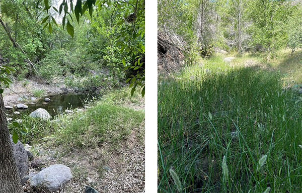
 Cave Creek There the road/trail crosses to the west side of Cave Creek, and a short distance later enters the Tonto National Forest. The trail continues up the canyon’s bottom, following an old forest road, FR48, crossing the creek several times. We were prepared to do some rock hopping to keep our feet dry if water was flowing in the creek, but it was bone dry on the first few crossings. We didn’t encounter streams that were splashable until the last two crossings. For this trek we went as far as the old 6L Ranch north of the old Phoenix Mine. This defunct cattle ranch was created in the early 20th century by brothers John and William Lewis. The two migrated to the Superstitions in the mid 1880s from Missouri. They moved operations to Cave Creek in 1906 so hence the “6” for the year and “L” for Lewis as the eventual ranch name. |
 We'll take the Maricopa Trail, |
The route we followed is a section of the Spur Cross Trail, which is also part of the Valley-circling Maricopa Trail. This becomes the old Forest Service road #48 just beyond the Tonto Park sign for #4 for Skull Mesa and the bluff. We bypassed the sign on our way out and went straight through the cow gate. The trail is well worn and maintained as it follows the old road to the Spur Cross Park boundary. From there the trail is not maintained but easy to follow on the old Jeep trail on the ridge. This dirt track that hangs on the hillside has acres of saguaros, prickly pear, ocotillo and cholla that glow in thorny halos when backlit by the sun. |
 Taking a well-deserved break. |
|
At a point about 0.8 miles past the turnoff to Cave Creek Trail #4, the old road has been washed out by numerous flash floods over the years and route finding can be a little tricky. I checked my previous route tracings at least twice to make sure we took the correct bend in the trail. I did find the last stream crossing easily, that on a previous trip had me walking up and down the stream of swiftly flowing deep water. |
 The woods are lovely, dark and deep. |
|
Our only wildlife observations were numerous birds (Cactus Wren, Cardinal, Gila Woodpecker and Phainopepla), a few rabbits and possibly a Javelina scurrying through the brush of the canyon. The petroglyphs are 0.25 miles past a second rusty gate marking the ranch boundary. The 6L Ranch sign that was at this boundary proclaimed until recently “PVT Property—No Trespassing” but the sign was merely historical. The old ranch property is part of the Tonto National Forest per a mining land swap deal. We went slightly off trail into the area of concentrated metates and petroglyphs. Lots of oohs and ahhs and picture taking. A metate is a ground stone tool used for processing grain and seeds by Native Americans. The stone is rubbed back and forth over a mano. Everywhere you look are pictographs, fossils, boulders with multiple metates and a few pottery shards. According to the 1974 archaeology report by William Holiday, the Cave Creek sites pottery is primarily Wingfield Plain and Gila Red, without painted decorations. |
 Plenty of petroglyphs. |
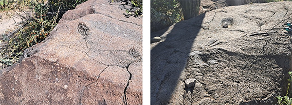 Metates. |
|
The entire band of hikers wandered the area finding petroglyphs or metates at every turn. We took our time, but surely left many more to explore on other trips. I pointed out the bluff above us which has Hohokam ruins, again for another day. We found shady spots or a comfortable rock and had a snack. We gathered on the trail for the return. |
 Even the plants are interesting. |
|
I don’t know how many of the hikers on this day had been to this place in their adventures, but I was so happy to share it. Hike Leader, Robbi Fowler. |
 Hikers taking pictures. |
|
About 0.8 miles from the petroglyph site, the return trail crosses the creek a couple of times. The remains of a relatively large mining operation can be seen to the west just above the canyon floor. A short section of the creek here seems to always have water in it, so there must be a perennial spring somewhere along that stretch. Another 0.8 miles and you arrive back at the trail sign where CC #4 trail starts. This time we stopped to see the sign and take pictures. |
 Trailblazers at the sign. |
|
A few yards past the last creek crossing, up a hill on Spur Cross Trail we came to the Metate Trail junction. After an awe-inspiring view down Cave Creek to the north, we started out on Metate Trail. This trail is well maintained and ever so much more inviting than just returning by the road. We encountered speckled shade, dry stream crossings, Indian Paintbrush, and unusual and flowering cactus. |
 Hikers gather around a saguaro. |
 Saguaro in bloom. |
|
From there we took a “bump out” path from the Metate - The Tohee. I’ve usually encountered wildlife of the sort I’d rather avoid on the Metate and especially the Tohee, but on this day the trip was benign. Then the group took a few minutes at what the map calls a Solar Oasis, a man-made lily pond with a solar pump and wildlife cameras, although we couldn’t spot the camera placement at this time. |
 Linda Helms with Bev Swarr Fisher. |
|
Thanks to Bev Swarr Fisher for most of the photos I used in this trip-log. That’s Bev with Linda Helms (L) in the photo. The old Spur Cross Dude Ranch site can be seen along the west side of the creek. Nothing remains of the ranch buildings except some foundations. There was a ranch-style main house, several guest houses, and a small swimming pool. There was even a short airstrip along the creek bottom used by one of the ranch owners, Warren Beaubien, to commute to the ranch from his home in Santa Ana, California, in his private plane. Tragically, he died when his 1949 Piper Clipper PA-16 crashed and burned on approach to the landing strip in 1953. The plane’s frame is left after 62 years, and can be seen off trail on a route left for another day. It should be mentioned that the cow fence we encountered on the trip north, we opened. It is a barbwire gate across the trail with a “keep closed” sign just pass the Trail #4 junction. On our return it was open. I’m not completely sure whether we left it open or it was opened after we passed. We closed it this time after we passed. Gate Policy: If a gate is closed upon arrival, leave it closed after you go through. If it is open, leave it open. Leaving a closed gate open may put cattle in danger. Closing an open gate may cut them off from water. Please be respectful, leave gates as found. The Metate trail ends at the southwest junction with Spur Cross Trail. We traveled up the hill, passed the picnic tables, park signs and portapotties and returned to the parking lot and our cars. In AllTrails the hike is only found under Cave Creek Indian Ruins at Chalk Canyon, AZ. The route shown there is correct to follow, but instead of doing the lollipop that went up the mesa to the Hohokam Ruins on the bluff (the right side of the lollipop). We kept to the left side only of the lollipop shown in AllTrails. |
|
Elevation: 2,340-2,615 feet. Getting there: 44000 N. Spur Cross Road, Cave Creek. From Loop 101 in Phoenix, take Cave Creek Road north to Spur Cross Rd and go 4.5 miles north to the parking area. Admission: $3 per person. Bring exact change. Details: https://www.maricopacountyparks.net 15 hikers, 8.2 miles, 3 hours 55 minutes, +-377' elevation change. |
|
→ More pictures, by
Bev. → More pictures, by Adrian. |
 Top of Page
Arizona Trailblazers Hiking Club, Phoenix, Arizona
Comments? Send them to the AZHC .
updated May 30, 2022