Outdoor Links
Hike Arizona
Trip Planning Guide
Trip Report Index
Calendar of Events
Library
|
Saguaro Lake Kayaking Day Trip Saguaro Lake March 16, 2023 by Chuck Parsons |
 Trailblazers are ready to kayak Saguaro Lake. [photo by Barbara] |
| Norma, Chuck, Barbara, and Eva. |
With all of our recent rains over the past several months, many of Arizona’s lakes, including Saguaro, Canyon, and Apache have reached 100% capacity. In fact, before we can even reach the lake today, we’re forced to wade thru a small body of water about 6” to 8” deep that has formed from the lake’s overflow rushing in from an inlet on the east side of Butcher Jones Beach. In years of launching kayaks from Butcher Jones, we’ve never seen this before. Yet another example of an abnormally wet winter for the entire state.
 Kayakers glide along the smooth lake surface. [photo by Barbara] |
It’s mid-March, under an overcast sky with temperatures in the mid-50s, as four Arizona Trailblazers pose for a quick group picture by our kayaks before finally launching from the beach at 9:40 a.m. As we push off from the shore, the lake’s surface is unusually calm and smooth, with hardly a ripple on the water or even the slightest breeze. With all the strong winds we’ve experienced on the last several winter kayak outings, we have to wonder just how long these calm conditions will last.
 Dark storm clouds are rolling in. [photo by Barbara] |
 Big Bird is keeping a lookout from this tall pinnacle. [photo by Barbara] |
Great Blue Herons have taken up residence on all of Arizona’s desert lakes like Saguaro Canyon, Apache, and Bartlett and on every kayaking trip we always see several of them stalking the shoreline in search of a meal. These large birds are extremely patient and will stand perfectly still like a marble statue for many minutes at a time, waiting for a fish to swim by. Today we see a couple of them flying overhead with big sticks hanging from their large beaks. And before too long we spot a Blue Heron rookery with numerous nests located high up in several tall trees near the shore. This is prime nesting season for the Great Blue Herons who call Saguaro Lake home.
 A colony of Great Blue Herons. [photo by Barbara] |
 Great Blue Herons build their nests high in the treetops. [photo by Eva] |
Because of the calm conditions so far today, we make excellent time paddling from Butcher Jones Beach to the main Salt River channel that forms the biggest part of Saguaro Lake. And not too long after entering the main channel, we begin to see increasing amounts of boat traffic on the lake today. As the morning progresses and the boat traffic increases, with larger and larger power boats, more of them towing one or two water skiers, and jet boats by the dozen zipping back and forth at high speed, I begin to wonder if this is actually Saturday instead.
 Norma and Barbara paddle alongside the reedbed. [photo by Eva] |
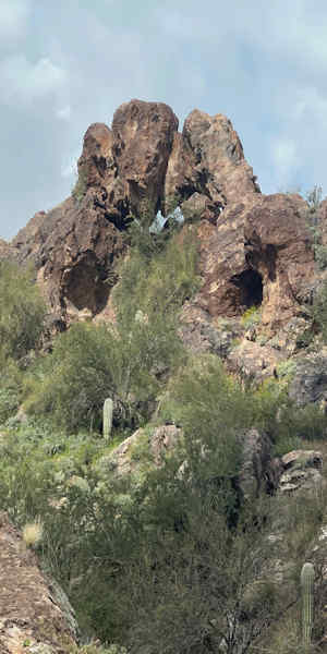 Elephant Rock. [photo by Eva] |
Did we get our days mixed up? Then someone in the group reminds me that this is Spring Break. Oh no! Outside of the hot summer months when everyone wants to be on the water, Spring Break is always one of the worst possible times, as far as crowds and large numbers of power boaters and jet skiers, to be on Arizona’s desert lakes. Far too much noisy activity and boat wake for kayakers and paddle boarders to deal with. Some of the waves created by these larger boats are big enough to capsize us. Note To Self: Never, ever schedule a kayaking trip during Spring Break.
 Shiprock looms dead ahead. [photo by Barbara] |
Still under heavy cloud cover, we continue paddling southeast past Campers Cove, Captains Nook, and Razorback Point before rounding a large bend in the channel and heading north towards Elephant Rock and Shiprock. We also keep an eye out for bald eagles and bighorn sheep that we’ve seen on several past outings to Saguaro Lake, but haven’t seen anything so far. In the meantime, the boat traffic continues to increase and becomes even louder, especially with a couple of the larger boats that seem intent on entertaining everyone on the water with their mammoth boom boxes the size of a large foot locker blaring their peculiar version of “music”, which in reality is nothing more than irritating noise loud enough to wake the dead.
 Norma is approaching Shiprock. [photo by Eva] |
We finally pass Elephant Rock, with its two large windows framing gray skies behind them, and then Shiprock, guarding the channel with its large rotating light beacon and surrounded by big red and white DANGER signs to stay clear. Warning to all boaters: If you decide to get drunk or stoned and ram your boat at high speed into this mammoth chunk of rock, sitting right in the middle of the channel, you will definitely destroy your boat and more than likely kill yourself and everyone else on board. And don’t believe for a minute that it hasn’t happened before.
 Norma, Barbara, and Chuck are all closing in on Shiprock. [photo by Eva] |
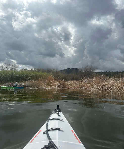 Searching for an entry point thru the reedbed. [photo by Eva] |
Once past Shiprock, we start looking for an area around the reed beds that we’ve used several times in the past to beach our kayaks, get out to stretch cramped legs, and take a lunch and rest break. But due to the unusually high water level, that area is now completely underwater. Then Norma suggests Bagley Flats Campground, another mile or so up the channel. This area has restrooms, picnic tables, and a nice wide gravel beach on either side of the boat dock and should be ideal for beaching our kayaks. So we continue paddling north and reach the campground in under 30 minutes.
 Now we’re approaching the Bagley Flats Campground. [photo by Barbara] |
But, much to our dismay, those wide gravel beaches are also completely underwater and have been replaced with slippery large rocks and small boulders, requiring us to disembark in knee-deep water and navigate treacherous wet boulders. Nope--too risky. Time for Plan C. But, wait! We don’t have a Plan C. Not yet, anyway. Carefully scanning the shore all around us, we spot a couple of long dirt roads on a high bluff on the opposite side of the lake that appear to be descending all the way down to the water’s edge. Now we have a possible Plan C. We start paddling across the lake and eventually see what appears to be a wide dirt and gravel take-out point. Paddle, paddle, paddle. Yes—this will make a great area to beach the kayaks and finally get out for a little R & R after over two long hours of kayaking.
 We finally locate a good place to stop for lunch. [photo by Barbara] |
 Eva and Norma take a relaxing lunch break. [photo by Barbara] |
Beaching our kayaks, we get out, use Mother Nature’s bountiful restroom, and find a good area to break bread. About 30 minutes later, we get back into our kayaks once again and reverse direction for Butcher Jones Beach. We’ve come over 4.5 miles to this point, so have the same distance to travel back. And, right on schedule, the afternoon winds begin to hit us square on. It was a perfectly calm day up to this point, but we knew it couldn’t last. Between the winds and constant rolling waves from ever-increasing boat traffic, the lake’s surface becomes increasingly choppy and difficult to navigate. Then, about half-way back to Butcher Jones Beach, we see huge dark and towering cumulonimbus clouds building up on the southwest side of the lake and before long start hearing rolling thunder moving across the water. Uh-oh! This is not good, people. Absolutely nowhere to get off the water at this point. Now, we need a Plan D.
 This bright red Cardinal is keeping a sharp eye on us. [photo by Barbara] |
Thankfully, the thunder soon fades away, but the winds pick up in intensity as we continue paddling northwest in the direction of Butcher Jones. If there’s a silver lining to be found here, it’s in the colorful wildflowers that have finally emerged from their slumber, with the warmth of the sun peeking out from time to time behind still-heavy cloud cover. Many brittlebush are ablaze in bright yellow and in full bloom on the rocky hills lining both sides of the channel, with occasional orange globe mallow and bright red Chuparosa in the mix.
 Barbara and Norma start the long paddle back. [photo by Eva] |
 Back among the reed beds once again. [photo by Eva] |
We continue paddling onward into the wind, dodging rolling waves from the boat traffic that are determined to capsize us, and steadily making our way back to Butcher Jones Beach. We round one rocky point after another and finally pass Peregrin Cove, just south of the beach. Butcher Jones comes into view at last and gives us the strength and the determination to paddle even harder. It’s 3:15 in the afternoon, under heavy cloud cover, when we finally hit the beach and disembark. Yet another great, but challenging, day of kayaking Saguaro Lake.
 Top of Page
Arizona Trailblazers Hiking Club, Phoenix, Arizona updated April 22, 2023
Comments? Send them to the AZHC .