Outdoor Links
Hike Arizona
Trip Planning Guide
Trip Report Index
Calendar of Events
Library
|
Col. Devin Trail Day Hike Mogollon Rim May 4, 2013 by Chuck Parsons |
|
|
“The hike is well worth the trip up. We highly recommend it for a future hike.” This is the last line from Tom Van Lew’s August 13, 1999 trip report on the Colonel Devin Trail. Only one other hiker joined Tom and his wife Jeannie for the hike that day, sponsored by our predecessor the Motorola Hiking Club. Apparently those words either fell on deaf ears or were simply long-forgotten until Ted Tenny reminded me last year that we haven’t done this hike since 1999. Could that possibly be right? We both had to wonder why and decided it was time to rectify that little oversight. So that’s the primary reason behind today’s hiking venture — our first visit to this beautiful area in nearly 14 years. Hopefully, we won’t let another 14 years slip by before setting foot on the Col. Devin Trail once again. |
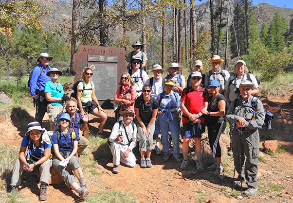 Near the Washington Park Trailhead, 21 Arizona Trailblazers gather around the Arizona Trail sign. [photo by Dave] |
|
Front Row: Quy, Anikó, Gary M., Arturo, Jackie, Sarah, Gary, Rose, and John. Back Row: Mike H., Dottie, Lori, Wendy, Chuck, Tony, Jim, Sheila, Mark, and Michael. Top of picture by sign: Michael R. |
 Starting out on the Colonel Devin Trail. [photo by Quy] |
 Trailblazers steadily work their way up the trail. [photo by Quy] |
|
The time is precisely 9:40 AM with a cool and refreshing temperature of 70 degrees on a beautiful Saturday morning in early May. Under cobalt blue Arizona skies, a light breeze is blowing out of the west as 21 charged Arizona Trailblazers strike out from the Washington Park Trailhead. The Colonel Devin Trail begins as a long-abandoned dirt road just beyond the Arizona Trail sign at the northwestern edge of the trailhead parking area. |
|
Very few trails below the Mogollon Rim actually make the journey all the way to the top of the Rim, and this rare exception rises from 5,840 feet at the trailhead to 7,240 feet where it tops out on the Rim Road, FR300. A critical piece of the 750-mile long Arizona Trail, the 3.2-mile long Colonel Devin Trail connects the Highline Trail #31 below the Rim to both the Fred Haught Trail and the General Crook Trail on top of the Rim. Colonel Thomas C. Devin fought on the side of the Union during the Civil War and was a veteran of 72 campaigns, including the battles of Antietam, Fredericksburg, Chancellorsville, and the bloodiest and deadliest of them all, the Battle of Gettysburg. After the war he was assigned to the 8th U.S. Cavalry, where his involvement with the Territory of Arizona involved pioneering this route down off the Rim in 1868. He led personnel from Fort Whipple on maneuvers to locate renegade Apaches using this route named in his honor. |
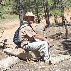
 Colonel Thomas C. Devin |
 Trailblazers make the first water crossing at Ellison Creek. [photo by Quy] |
 Crystal clear Ellison Creek flows merrily along. [photo by Chuck] |
 A small waterfall at trail’s edge. [photo by Chuck] |
|
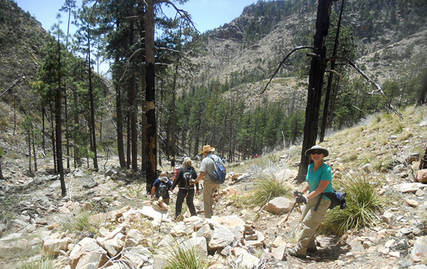
The Colonel Devin Trail continues to climb steadily for the next 1.5 miles through an open forest of pinyon and Ponderosa pine, oak, alligator juniper, and manzanita. Soaring sycamores, with their gleaming white trunks, grow along the water’s edge. We will make several easy water crossings over Ellison Creek as it follows the pull of gravity and eventually joins forces with a network of other small creeks and streams draining millions of gallons of water off the vast Mogollon Plateau. After heavy summer monsoon rains pound the Rim, these peaceful and lazy streams can transform into raging, muddy torrents within minutes. |
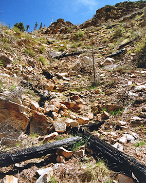
 Pipeline carrying water from the Blue Ridge Reservoir. [photo by Quy] |
|
This water pipeline pulls ice-cold water from the depths of Blue Ridge Reservoir, high atop the Rim about 15 miles to the northwest, and becomes the source of the East Verde River near Washington Park. Most of the pipeline is buried underground, but this section is exposed as it crosses a large wash. Despite a heavy layer of insulation surrounding the pipe, it is still very cold to the touch and serves as a reminder of why trout and not human swimmers thrive in the seven sparkling blue Rim Lakes scattered across the Mogollon Plateau. |
 John and Dottie discuss their next move. [photo by Quy] |
 Wendy smiles for the birdie. [photo by Quy] |
 Dave pulls up a boulder and takes a breather. [photo by Quy] |
 Arturo tries to raise one of his ham radio buddies. [photo by Quy] |
 Trailblazers trudging up the Col. Devin Trail. [photo by John] |
 Trailblazers encounter the first set of switchbacks. [photo by Chuck] |
 John finds his way across the creek. [photo by Dave] Numerous wildfires have swept across these forests over the years, the most recent one being the Water Wheel Fire of August, 2009, leaving thousands of blackened and charred tree trunks, both standing and as deadfall, and totally denuded hillsides in their wake. Originating at the Water Wheel Campground from an unattended campfire left by careless campers, the Water Wheel Fire torched nearly a thousand acres of prime timber before being brought under control. Unfortunately, we have seen a lot of this on recent hikes including Wilson Mountain and Pine Canyon — mounting evidence of the devastating result of prolonged drought and severe bark beetle damage to Arizona’s endangered forests, given a helping hand by careless and thoughtless humans. As Smokey the Bear always used to say, “All it takes is one careless match.” and “Only you can prevent forest fires.” Sadly though, some people just never listen and never learn and we all suffer the consequences. |
 The area is slowly recovering from the 2009 Water Wheel Fire. [photo by Chuck] |
 Hikers continue making their way up the switchbacks. [photo by Chuck] |
 New Mexican Raspberry [photo by Quy] |
 Indian Paintbrush [photo by Quy] |
 Looking back down the valley from the switchbacks. [photo by Quy] |
|
As we continue to make our way up the switchbacks and get closer to the Rim, I radio ahead to Michael H., who did this hike several years earlier, and ask if he has seen the turnoff for the Railroad Tunnel Trail which is about a quarter-mile below the Rim. He replies that he has not and before we know it we’re all standing on Forest Road 300 (the Rim Road) at the top of Mogollon Rim. We had earlier discussed checking out the railroad tunnel on the way up to the Rim but will instead try to find it on the way back down. I would later find out there is a very good explanation for not finding the tunnel sign at trail’s edge where it has stood for many years. Turns out it burned to the ground, along with nearly a thousand acres of surrounding forest, in the previously-mentioned Water Wheel Fire of 2009, and was never replaced. |
 Taking a break on top of the Rim. [photo by Quy] |
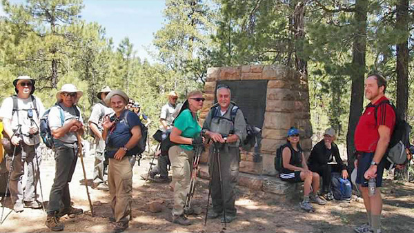
 Trailblazers gather around the Monument to the Battle of Big Dry Wash. [photo by Dave] |
 Close-up shot of the historical marker. [photo by Dave] For a brief synopsis just in case the marker is too difficult to read, this monument commemorates the July 17, 1882, Battle of Big Dry Wash, fought seven miles north of here. A small band of renegade Apaches had earlier attacked some local ranches, killing several settlers. A four-hour clash between the U.S. Cavalry and the renegades resulted in two Cavalry casualties and twenty Apache casualties. This engagement would be the last major battle between the United States Army and Apache warriors in the Northern Apache Indian Wars. |
 Dottie and John pose by the General Springs Cabin sign. [photo by John] |
 Forest Service sign marking the General Springs Cabin. [photo by Dave] |
 General Springs Cabin. [photo by Quy] |
 Cabin side view with Trailblazers around the front porch. [photo by John] |
 Interior cabin view with Michael H. peering in the doorway. [photo by John] |
 Photographer Quy sits in the cabin doorway. [photo by Quy] |
|
This lush green meadow and patch of cool shady forest near the General Springs Cabin is the perfect lunch spot for 21 trail-weary Arizona Trailblazers. I check my backpack thermometer once again and find that it’s still reading a very pleasant 72 degrees where it has been for most of the day. Another day of hiking in paradise along the trails of Arizona’s high country. It just doesn’t get much better than this. |
 Trailblazers spread out for lunch in the surrounding forest and meadow. [photo by Quy] |
|
We have enjoyed an almost unprecedented string of hikes with virtually perfect hiking weather over these past several months of tramping across both desert and mountain trails. But we’re also savvy enough to know such a good thing can’t last much longer, with weeks and months of triple-digit weather just around the corner for us desert dwellers. So we’ll just enjoy these days one at a time while we can. All too soon we have to pack up and head back down from Rim Country, but we still have one more objective in front of us (other than reaching the trailhead, that is) and that’s to locate the turnoff to the railroad tunnel and do a little exploring there. So we’re off. |
 Heading back down the road to the FR300 Trailhead. [photo by Quy] |
 Hitting the top of the switchbacks for the hike back down. [photo by Quy] |
 The trail gets rougher as we descend further. [photo by John] |
 Trailblazers make their way up the steep, boulder-filled Railroad Tunnel Trail. [photo by John] |
 Entrance to the railroad tunnel. [photo by Dave] |
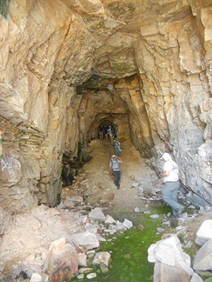 Trailblazers explore deep inside the railroad tunnel. [photo by John] |
After we head back down off the Rim, Michael finally manages to locate the elusive Railroad Tunnel Trail, and it’s certainly not hard to see why we missed it earlier on the hike up. The trail is not marked at all (of course not: the sign burned down. Remember?) and after we turn off the Col. Devin Trail it looks more like a drainage choked with boulders and downfall than an actual trail. It’s rough going for nearly a quarter-mile as we slowly scramble and maneuver our way up and over numerous large rocks, boulders, and downed trees across our path. We round one last bend in the torturous tunnel trail and there it is — a long-abandoned humungous hole in the rock that is nothing more than a curiosity now, albeit a very big one. |
|
It all begin with great ambition and big plans, in the early 1880s when the Arizona Mineral Belt Railroad came up with a scheme to transport copper ore from the booming copper mines in Globe up to the newly-completed Atlantic and Pacific Railroad Line in Flagstaff. The biggest obstacle was determining how to cross the rugged and imposing Mogollon Rim. Impossible to go straight to the top and way too expensive to build enough switchbacks to make it. |
 Dottie and Wendy check out the powder room. [photo by John] |
 Heading back down the Railroad Tunnel Trail. [photo by John] |
|
How about a tunnel? So entrepreneurs and investors eventually raised enough cash to excavate a 3,100-foot-long tunnel through the upper levels of the Mogollon Rim. Makes sense, right? Unfortunately, in 1888 the company went bust, having dug a mere 70 feet into the rock. To be sure, for the times this was one heck of an expensive hole in the rock to nowhere. |
 Trailblazers take a break after exploring the Railroad Tunnel. [photo by Chuck] |
|
By 2:15 in the afternoon we all arrive safely back at the Washington Park Trailhead with the exact number of hikers we started out with (21), which is always a good sign. More hikers than you start out with is certainly okay, but less is not good at all. I check my camera bag thermometer one last time and see that it has warmed all the way up to 75 degrees. Another perfect day of hiking in paradise. |
 Back at the trailhead for a little post-hike libation. [photo by Quy] |
 Nuts! You mean we missed the lunch special? [photo by John] |
We clean up, have a few tailgate post-hike parties to celebrate one more hike we can check off the old bucket list, and most-importantly discuss dinner options. We finally settle on the Buffalo Bar & Grill in Payson. About half the group decides to head back home, while ten of the more ravenous hikers who can’t wait that long to eat belly up to the closest table at the Buffalo Bar & Grill and prepare to dive in. |
 Ten hungry Trailblazers prepare to chow down. [photo by John] |
 Top of Page
Arizona Trailblazers Hiking Club, Phoenix, Arizona
Comments? Send them to the AZHC .
updated January 12, 2016