Outdoor Links
Hike Arizona
Trip Planning Guide
Trip Report Index
Calendar of Events
Library
Pinaleno Mountains
June 11-14, 2009
by Chuck Parsons
 Riggs Flat Lake on top of Mt. Graham |
|
One of the most beautiful and picturesque alpine lakes in Arizona, Riggs Flat Lake sits high atop Mt. Graham at an elevation of 8,500 feet. Riggs Flat is one of the most productive trout lakes in Arizona, and on any given day during the summer months hopeful anglers can be found scattered along the shoreline or trolling across the lake in boats, searching for the elusive Rainbow, Brown, and Brook trout that prowl these icy cold waters. |
 A second view of Riggs Flat Lake [Cyd] |
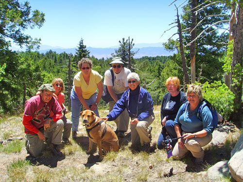
For obvious reasons, Riggs Flat Lake Campground, adjacent to and overlooking the lake, is the most popular of the seven campgrounds on Mt. Graham. On a cool and clear Friday morning in mid-June, nine Arizona Trailblazers decide to do a warm-up hike around the lake in preparation for our main hike later in the morning to the top of Webb Peak. |
 Hikers on a log. |
|
From left to right, Debbie, Sandy, Karen, Cyd (standing), Clara, Bill (seated on ground), Mike, Kathy, Butch, and Chuck take a rest break on our hike around the lake. This scenic trail completely circumnavigates the lake and can easily be completed in about twenty minutes — as long as you don’t keep stopping to take pictures. Since most of the people on this trip have never even been to Mt. Graham before, we take our time and stop to smell the roses along the way. And this is good since we should all try to keep in mind that it’s not the destination that counts nearly so much as the journey that takes us there. |
|
Just how many tree huggers does it take to completely encircle one tree? In this case it turns out to be a total of three. On our hike up the Webb Peak Trail on Friday afternoon we discover this monster ponderosa pine that just begged to answer the question. So three of our group volunteer as tree huggers of the day as Sandy captures a special Kodak moment, one of many during the course of this Mt. Graham experience. |
 Tree Huggers invade Mt. Graham [Sandy] |
 Sandy and the giant ponderosa pine [Cyd] |
Our photographer Sandy honors Cyd’s request to pose in front of the same giant ponderosa. Some of these older ponderosa pines grow very tall – up to 100 feet – while others such as this one seem to expand horizontally and develop huge girths instead. This is definitely one of the largest in circumference that we have seen in a long time. These older and larger ponderosas also develop an extremely thick layer of bark, making them highly resistant to forest fires. We’ve seen some on previous hikes whose lower trunks were completely blackened and charred, yet the tree was still thriving and growing. |
 On top of Webb Peak [Cyd] |
|
From left to right, Bill, Karen, Kathy (with Butch in front), Chuck, Sandy, Clara, and Cyd stop for another Kodak moment near the base of the Webb Peak lookout tower. Butch is in charge of keeping the group together and making sure that no one strays or lags too far behind. Those who do must answer to Butch. Debbie and Kathy’s husband Mike are also part of our group, but they decide to turn back before the peak and get a head start return to the trailhead. |
 Webb Peak Lookout Tower |
From the Columbine Horse Corral and Campground trailhead, the Webb Peak Trail is a little over a mile in length, with almost 1,000 feet of elevation gain, to the 10,030 summit of Webb Peak. This fire lookout tower sits at the top of Webb Peak, commanding a spectacular view of the surrounding area. A couple of our hikers eagerly brave the challenging climb to the top for the view, but afterwards are more than grateful to return to terra firma at the base. The stairs on most of these lookout towers can be pretty tricky to negotiate at best, and many hikers who start climbing decide to turn back before reaching the first or second platform. |
|
After her tough climb up and down the lookout tower, Karen decides to take a stroll around the tower’s base to check out the area and make sure her hiking knees are still working properly for the long descent back down the Webb Peak Trail. Once she’s satisfied that her knees are up to the task and everyone else is ready to hit the trail again, we regroup for the trek back down the mountain to the trailhead and our waiting vehicles (where we will hopefully find Mike and Debbie waiting for us). Butch, gather up the stragglers and lead the way! |
 Karen near the base of the lookout tower [Cyd] |
|
Shortly after our return to the campground, Park Ranger Skinner drops by to inform us of the progress in trying to locate two wayward black bear cubs that he and his staff have been trying to find for the past couple of days. The day before our arrival at Riggs Flat Campground, some careless campers had left a partially eaten bucket of fried chicken unattended on the table at their campsite. Shortly after they left, an opportunistic bear, probably attracted by the smell, took advantage of the situation and chowed down on the Kentucky Colonel’s finest. Then the bear proceeded to hit several neighboring campsites to satisfy her hunger. Naturally, that created quite a stir of excitement, and the cry of “BEAR!” swiftly echoed through the campground. Unfortunately, she also had a couple of young cubs in tow and upon her later capture they scampered off into the forest. Mama bear was confined to quarters while the rangers continued searching for the cubs. |
 It was this big! |
Ranger Skinner informed us that as soon as they could capture the cubs, the family would be reunited and then relocated far away from the campground. But if they failed to find them soon, they would be forced to put the female down since trying to relocate her with her cubs still on the loose would be an exercise in futility. When we left the campground on Sunday morning, they still had not been able to locate the little cubs. |
|
Update July 9, 2009: I just talked to the folks at the Safford Ranger District for the latest information on the female bear and her cubs at the campground. Sadly, the bear cubs were never located, and the female was eventually destroyed. They really don’t know if the two cubs are old enough and strong enough to survive on their own or not. So this single moment of carelessness on the part of one unthinking camper may have resulted in the needless death of three black bears. People who knowingly or unknowingly (as in this case) feed the wildlife are almost always doing more harm than good, and the end result is often tragic. Clara takes on the interesting task of recording a few comments for posterity from all of us participating in this trip. She is also the official entertainer during our nightly campfire socials. |
 Clara, our videographer and entertainer [Cyd] |
Clara has the voice of an angel and could probably go professional should she choose that route and find the right backers. She sings for her dinner on all three nights at the campground, belting out songs from A to Z. I also brought along several works from the Poet of the Yukon, Robert W. Service, for Clara to read to us. She willingly obliges by reciting The Cremation of Sam McGee and The Shooting of Dan McGrew, among others. |
|
It’s always interesting on these camping trips how certain people naturally assume certain responsibilities while I, as event organizer, get to sit back and just watch in amazement. |
|
On this trip Bill volunteers his services as our official fire starter and fire keeper and is always Johnny-on-the-spot early every morning and early every evening, cleaning and preparing the fire pit and stoking it as necessary. By the time the rest of us start gathering around, Bill has a nice roaring campfire going for us and all we have to do is place our cold bodies in position around the fire and soak up the welcoming heat. |
 Bill the Fire Starter [Cyd] |
 Sitting around the old campfire [Sandy] |
Around a crackling campfire, Karen watches as Cyd and Bill are deep in discussion about world affairs and current events. For a change, we actually have more firewood than we can probably use on this trip, and we burn plenty of it trying to ward off the morning and night chill at our 8,500 foot campsite overlooking the lake. We take some wood back with us on Sunday morning and leave the remainder for the next campers to use. |
|
Now let’s see – should it be post “A” into receptacle “B” first or post “F” into receptacle “G”? “Wait a minute, Mike, I think we’re missing some pieces here. Butch, did you just pick up something? Bring that back here!” Mike and Kathy carefully go over detailed assembly instructions for their new propane camp grill. |
 Some assembly required [Karen photo] |
|
They had picked up a Wal Mart special just a day or two before the trip and are now in the final stages of assembly. By Saturday afternoon they complete the grill just in time to make some burgers for the potluck dinner. |
 Gathering of hikers at the Ash Creek Falls Trailhead [Bill] |
|
On a clear and cool Saturday morning in the Pinalenos, fourteen Arizona Trailblazers, along with two chomping-at-the-bit canine companions, assemble at the Ash Creek Falls Trailhead. From left to right, Karen, Ann, Sandy, Clara and Ralph (kneeling in front), Barry, Bill, Kathy, Mike B., Sheila, Chuck, Cyd (kneeling in front of sign), and Doug pose for a quick group picture before starting our trek down to Ash Creek Falls. Mike A. and Zeke have already hit the trail running. Debbie has decided to sit out this hike and instead spend the day relaxing around our camp and helping in the search for the two missing bear cubs. She will also serve as our camp guard while we’re away, patrolling the area with her grenade launcher and AK-47 assault rifle at the ready. |
|
We start down the heavily forested Ash Creek Falls trail among towering ponderosa pine, Douglas fir, blue spruce, and scattered stands of quaking aspen, whose leaves are quivering in the light breeze blowing through the high overhead canopy. From a lofty 9,500 feet at the trailhead, we will drop a total of 1,400 feet in elevation to 8,100 feet at the falls overlook. Total round-trip hiking distance will be a little over five miles. We have plenty of time today, and there’s a lot to see along this scenic alpine trail, so we’re going to take our time and enjoy a nice relaxing hike to the falls. The return trip will force us to hike even slower since we have to regain that same 1,400 feet of elevation in the very thin air of Mt. Graham’s upper reaches. |
 Hikers on the Ash Creek Falls Trail |
 How the heck do we get through here? [Karen] |
Bill, Kathy, and Cyd ponder the gravity of the situation as they try to navigate around this fallen tree completely blocking the trail. Numerous trees have fallen across Ash Creek Falls Trail since our last visit to Mt. Graham. Many have already been cut to clear a path, but many others have not and require us to navigate over, under, or around them as we slowly make our way down the trail. |
|
All trees in the forest die and fall down sooner or later, but that process has been greatly accelerated in recent years due to massive pine bark beetle infestations throughout Arizona’s forests and the resulting death of millions of trees. |
 Stopping to reconnoiter [Cyd] |
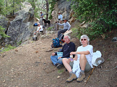
About half a mile from the trailhead we reach the Webb Peak Junction, where a 2.7-mile loop trail takes the hiker to the 10,030 summit of Webb Peak and its fire lookout tower. Since most of us had already done the shorter version of this hike yesterday, we will continue on our way to the falls. But first the group takes a short rest break in this peaceful forest setting at the edge of a large meadow and waits for everyone else to catch up. Butch takes advantage of the opportunity to munch on some lush green grass. |
|
Near one creek crossing about a mile from the trailhead, we come across this large rusted boiler, along with scattered parts like gearboxes and valve heads, half-buried along the banks of the creek. This is the site of the long-abandoned Ash Creek Sawmill, the largest of seven sawmills operating full-time on Mt. Graham from the 1890s through the late 1930s. |
 Ash Creek Sawmill boiler |
|
This sawmill provided lumber for the numerous Civilian Conversation Corps construction projects on Mt. Graham as well as lumber for the growing communities of Safford, Thatcher, and Pima near the base of the mountain. As we continue descending, the trail crosses the creek from time to time, and we’re treated to a number of these small picturesque waterfalls cascading and tumbling over large boulders lining the creek bed. |
 |
 |
| Waterfalls along Ash Creek | |
|
The life-giving waters of Ash Creek flow year around and support a thick growth of skunk cabbage, raspberry bushes, and more shades of green than can possibly be imagined in the rich and diverse plant life that thrives along the banks of this creek. Riparian habitats such as this one along Ash Creek continue to vanish across Arizona with relentless and uncontrolled development and the resulting destruction of the environment, so it’s critical that remaining unspoiled and pristine habitats like Ash Creek continue to survive. Thick lush bracken ferns form a solid carpet of green as far as the eye can see along this stretch of the trail. |
 Bracken ferns carpet the forest floor. At 1.7 miles we come across the Slick Rock horse detour that routes horse traffic around treacherous Slick Rock, a section of the trail that had to be blasted out of solid granite. |
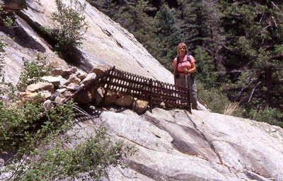 Karen at the Slick Rock Formation |
At Slick Rock, three heavy metal grates are pounded into the granite bedrock to help keep the narrow, rocky trail stabilized and anchored in place. Small boulders are then used as fill between the grate and the granite slick rock to form a makeshift trail. This section that Karen has just traversed shows some major damage with the collapse of part of the metal grating, which makes it even more challenging. |
|
Near the last metal grate, we make yet another creek crossing and discover the waters of Ash Creek cascading and sheeting down a steeply sloping scarp of solid granite bedrock, dropping about fifty feet or more into the creek bed below. |
|
It looks like an extreme sports version of Slide Rock in Oak Creek Canyon, but only the very foolhardy or the suicidal would even think about sliding down this treacherous and deadly rock slide. Just getting into position for this picture is worrisome enough for me, realizing that with one small misstep I could easily lose my footing and wind up in an uncontrolled slide all the way down to the bottom. |
 Slick Rock water slide for the suicidal |
 Apache Plums bloom in profusion |
The ravine we’re hiking in begins to narrow down, and the thick plant growth closes in from both sides of the trail. Apache Plums along a long stretch of the lower trail are blooming in profusion with their large white flowers. The trail also takes us along several deep and inviting pools of clear cold water in Ash Creek, where we see a number of small trout hanging suspended above the bottom of the pools, darting about nervously at the sight of our shadows. Now I wish that I had brought along my ultra-light trout tackle with me. |
|
We see penstemon blooming along the trail from time to time, with their tall spindly stalks nodding gently in the breeze. |
|
|
While stepping off the trail to get a better picture of one of the many small waterfalls we encounter along the way, I discover this strikingly different looking species of penstemon with much larger blooms and more intense coloration. It is also continually nodding in the breeze, and I have to wait for some time for a break in the wind before finally snapping this picture, but the wait was well worthwhile. |
 The perfect Penstemon bloom |
|
Patience is often the key factor in getting a good picture, especially with flora and fauna. Especially along the last half of the trail on the way to the falls, we find many lizards scampering about or sunning themselves on large granite outcroppings. |
|
 Sunbathing Yarrow’s Spiny Lizard |
Most are very skittish and dart off long before we can even get into position to take a good picture. I get a lucky break with this Yarrow’s Spiny Lizard who doesn’t seem to mind my presence as long as I don’t get any closer. My 200 mm zoom lens gives me an added advantage in being able to stay outside of his circle of comfort. I step just a little closer for one last picture, and he vanishes in the blink of an eye. |
|
This is one of the larger waterfalls on Ash Creek before reaching our final goal of the day, Ash Creek Falls. Somehow, I manage to miss this particular one, but lucky for us Doug captures this spectacular falls in its glorious setting. The Ash Creek Falls Trail has to rank as one of the most beautiful and diverse riparian trails in all of Arizona. It’s certainly an all-time favorite among the participants on all four of the Mt. Graham camping trips that I’ve organized over the years. |
 One last waterfall before the Big Kahuna [Doug] |
 Crossing the last metal grate [Sandy] |
Barry carefully picks his way across the last of the three large metal grates along the Slick Rock section of the trail, this one running right across the creek and forming a small dam. Sheila and Doug are not far behind. With this last grate crossing, we are less than a half mile from the Ash Creek Falls overlook and our turnaround point for the day. A huge tilted slab of the granite slick rock this section of the trail is named after can be seen behind Sheila, while more blooming Apache Plums are behind Doug. |
|
Arizona Trailblazers, with Sheila in the lead, slowly work their way down the final home stretch of trail before reaching the falls, where we’ll stop for photo-ops and a well-deserved lunch break. I’ve hiked this trail at least five times over the years, and each time the falls seem to be farther away than I remember from the previous hike. This trip is no exception, and I keep telling everyone the falls are just around the next bend in the trail. |
 Final stretch to Ash Creek Falls [Doug] |
|
We go around several more bends before finally reaching the falls, at last. Hmmm — I wonder just how much longer I can get away with that little ruse before the others start catching on? We round one last bend in the trail (the genuine article this time) before finally catching our first glimpse of the falls at a large rocky overlook along trail’s edge. |
|
 Ash Creek Falls at last! |
 close-up of the cascading water |
|
Slightly over 200 feet in height, Ash Creek Falls is the highest perennial waterfall in southern Arizona. In a scene straight out of Arizona Highways Magazine, the waters of Ash Creek drop from a nearly vertical granite cliff face and cascade ever so slowly down the cliff to a small pool at the bottom. As spectacular as the falls are now at low water flow, I can’t even imagine what this scene looks like in March and early April after a heavy spring runoff or even during July or August after a heavy monsoon downpour. |
|
|
We all take a nice leisurely lunch break at the falls after our 2.5 mile trek to this overlook. In the background it looks like Zeke is anxious to hit the trail again for the return hike back to the trailhead, while the rest of us are ready for a nice nap. Where the heck does he get all that energy anyway? These young whippersnapper pups! |
|
|
When the wind shifts and comes from the direction of the falls, we can just begin to hear the water softly cascading down the cliff face as Ash Creek responds to the laws of gravity and drops off the cliff, plummeting over 200 feet into a small pool far below at the cliff base. Lower Ash Creek then continues on its course for another six miles before emptying into a series of pools known as Cluff Ponds. |
 Lunch break at the falls overlook [Karen] |
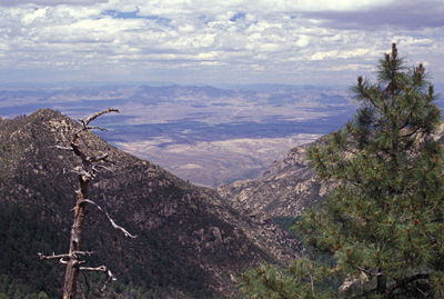 View from Ash Creek Falls Overlook |
This spectacular view from the falls overlook takes in Safford and the Gila River Valley, lying over 5,000 feet below us. The blue waters of the Gila River, flowing just to the north of Safford, can be seen in the middle of the picture. Far to the north lies the Mogollon Rim and the White Mountains. |
|
While the folks in Safford and the valley far below are baking in 100+ degree temperatures, we enjoy refreshing cool breezes and ideal temperatures in the mid 70's. What a difference several thousand feet of elevation can make! |
|
|
Debbie, Ann, and Karen check out some of the many delicious entrées spread out across the camp table, including a garden salad, macaroni salad, guacamole dip, chips and salsa, burgers, enchiladas, grilled chicken, dinner rolls, and finally Tonka Toasters (ask Bill) and S’mores for desert. All washed down with tea, wine, and cold beer. Anybody ready for another hike? Anyone? Hello? |
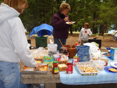 Mt. Graham Saturday night potluck extravaganza [Cyd] |
 Jiffy Popcorn time! [Cyd] |
 done to perfection [Cyd] |
|
Mike B. carefully adjusts the ever-swelling pan of Jiffy Popcorn on the grill for just the right amount of heat. Too little, and the corn stops popping. Too much, and the corn scorches. It’s a real challenge and a fine balancing act to get the popcorn perfectly placed over the uneven heat of a campfire grill, but Mike has just the right touch. When finally done to perfection, he makes the rounds and offers fresh popcorn to all of us gathered around the campfire. So Clara is now our official entertainer, Bill is our official fire keeper, and Mike is our official popcorn maker. Looks like we’re ready for another camping trip now. |
|
 Sunday morning around the campfire [Sandy] |
Cyd, Bill, Barry, and Debbie bundle against the morning chill, with overcast skies completely blocking the sun. It looks like our string of good weather on this trip may have run its course on our last day on Mt. Graham. Hopefully, the skies won’t open up and start spitting rain on us as we break down camp and prepare to leave. Weather in these mountains changes rapidly: it can go from solid overcast to sunny skies or vice versa in a matter of minutes. |
|
Sheila and Doug enjoy a quiet moment of reflection on our last day at camp as they sip from cups of hot coffee to help ward off the penetrating morning chill. We wish Doug and Sheila the very best in their new relationship and their future together. Soon it will be time to start breaking down camp, packing away all of our gear, saying all of our goodbyes, and finally heading back down the long and winding Swift Trail, back to home and civilization. |
 Sharing a quiet moment together [Sandy] |
|
I have been back to this mountain time after time over the years, and it almost seems to have some sort of magical powers over me that keep pulling me back one more time. Mt. Graham and the Pinalenos have always held special meaning for me and have always been a favorite place for personal solitude and reflection, and I hope they will serve the same purpose for all of you as well. I’ve probably said more than enough already, but I would like to close with just one final observation, one last note to reflect on and consider. As human populations around the world continue to grow and expand and mega-cities continue to burst at the seams, we will continue to lose more and more of our remaining wild and free places as well as more and more of our already rapidly diminishing wildlife populations. Arizona remains one of the fastest growing states in the country, and wild places here from pristine desert areas to unspoiled riparian habitats like Ash Creek are being destroyed or severely compromised at an alarming rate. One thing we can all do is to help ensure that special wild places like Mt. Graham and the Pinalenos will remain forever wild and free for all future generations that will follow in our footsteps. “The earth does not belong to us. We belong to the earth. The earth is our mother. What befalls the earth befalls all the sons and daughters of the earth. This we know: All things are connected like the blood that unites us. We did not weave the web of life. We are merely a strand in it. Whatever we do to the web, we do to ourselves.” Chief Seattle |
|
 Top of Page
Arizona Trailblazers Hiking Club, Phoenix, Arizona
Comments? Send them to the AZHC .
updated April 18, 2020