Outdoor Links
Hike Arizona
Trip Planning Guide
Trip Report Index
Calendar of Events
Library
|
Canyon of Fools Sedona May 10, 2020 by Mark Purcell |
|
 All here. Everyonei is distancing. [photo by Mark] |
| Heather, Michael, Mark, Li, Tom, Tamar, Kevin, Debbie, Chris |
 It was this big! [photo by Tom] Scouting potential routing in March, 2020, offered a number of options, so I was anticipating generous flexibility in planning even perhaps on the day of the hike. However COVID19 surfaced, and some trails in the vicinity (specifically around Devil’s Bridge) were closed. Fortunately, there were enough other choices that the hike was still viable. So, let’s plan on scheduling this, say, in the fall of 2020. Fast forward to April, 2020, and the May schedule is bleak due to club and state restrictions. Knowing that many were missing the camaraderie of group hiking, I sent out a “feeler” to individuals who had hiked on my treks previously and received considerable interest. Then, in early May, as new hikes were again permitted with restrictions, the hike was posted and with the 10 hiker limit and was at capacity the same day. With no formal carpools, participants drove directly to the expansive Arizona Cypress Trailhead in West Sedona. Covering approximately 100,000 square feet, other than hikers and bikers, this site also facilitates launches of hot air balloons and target shooting. Strangely, the entrance to this trailhead is not signed on the main road, so directions to the uninitiated have to include other markers. Anticipating temps could approach 90° by early afternoon, we got a 7 AM start. |
 Let’s get organized. [photo by Tom] |
|
Eleven trails were to be visited on this hike. One of the first trails was the Anaconda, which was not originally included when I scouted the hike but used as a detour to avoid a third crossing of, at that time, an actively streaming Dry Creek. But, it provided such a pleasant trek with outstanding views it was inserted into the final routing. And it had an intriguing name! |
 What a lovely day for hiking! [photo by Tom] |
 The best of Sedona’s red rock country. [photo by Tom] |
 Let’s pause so the others can catch up. [photo by Tom] |
|
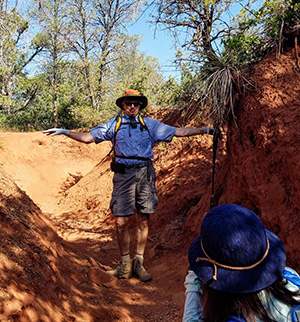
From Anaconda, we next spent a brief time on Arizona Cypress, crossed a now “dry” Dry Creek onto the OK Trail. After encountering the compact Dawa Trailhead and crossing Boynton Creek Road, Canyon of Fools was next. Now, with a trail name that presented as both ominous and presumptuous of questionable discernment within our group, I would not have been surprised if participants approached this trail with trepidation. In reality, the Fools trail definitely does not resemble an Arizona canyon—more like a ditch! Yes, the walls did approach 15 feet high in spots, and I could see in the old West you may not have aspired to be an outlaw looking up above at the sheriff’s posse on the ledge. However, this trail did provide a wildlife bonus as we encountered a tarantula making its way down the side. |

|

|
| Heading on down the trail. [photos by Mark] | |
 Somebody put up a shrine. [photo by Mark] |
 Let’s take a break. [photo by Mark] |

|

|
| Tarantula. [photos by Mark] | |
 A bloomin’ hedgehog. [photo by Mark] |
 Moving right along. [photo by Mark] |
|
First viewed from about 2 miles away on the Anaconda trail, as we approached the Mescal Trail the namesake mountain was now towering above us. Although there is a tempting saddle at its center, scouting in advance indicated that a Class 3 rappel would be required to scale, so, let’s go around it. Moving clockwise, we continued on the Mescal Trail to Deadman’s Pass, which will guide us parallel to the backside of Mescal to our right. To the left were magnificent views of the Secret Mountain Wilderness, which on my scouting hike elicited all manner of projections of potential narrow shelf opportunities. These musings were aided on this hike by my participants who also speculated, and one actually pointed out an apparent social trail that may be my introduction to the possibilities. After we all came out alive after one mile on Deadman’s Pass, we tumed onto Long Canyon trail in the direction of our origin. After some connector trails and trekking along the road, we reached the Dawa Trailhead and a short 0.4 mile revisit on OK (this was the only interval where we repeated any trail). Our last segment was on the nicely shaded continuation ofArizona Cypress that darts around Dry Creek. Back at the Arizona Cypress Trailhead, where we said our goodbyes and headed home. In closing, I would like to thank my “team” who did a great job of social distancing internally and as we encountered other hikers. An unexpected development the day after the hike was that I developed a fever that could be a COVID19 symptom. I arranged for a test and notified all the group. Fortunately the result was negative, but I offer this posthike occurrence as instructive of recommended actions if any member of a hiking party has a COVID19-related symptom (and can get tested) within 10 days. → More pictures, by Tom. |
|
Supplemental Report by Li Li |
|
Thank you, Mark, for letting us know the good news. I am happy that you have recovered from the heat! It was another beautiful hike that you led this time. Thank you for your meticulous planing. Everything was perfect! Here is the link to my photos, I do not have lots of good ones but you feel free to use it. I added some of Tom’s pictures to mine as you can see. → More pictures, by Li.Have a great week, everyone, and keep safe and healthy! |
 Top of Page
Arizona Trailblazers Hiking Club, Phoenix, Arizona
Comments? Send them to the AZHC .
updated May 18, 2020