Outdoor Links
Hike Arizona
Trip Planning Guide
Trip Report Index
Calendar of Events
Library
|
Harquahala Summit Day Hike Harquahala Mountains Wilderness April 9, 2016 by Chuck Parsons |
|
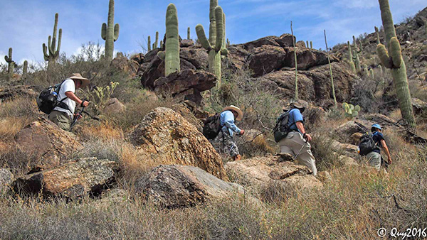
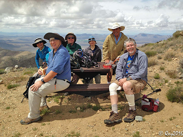
 The Stupendous Six at the Harquahala Trailhead. [photo by Quy] |
||||
|
||||
|
Under partly cloudy skies, with a light breeze blowing out of the southwest, six Arizona Trailblazers set out from the Harquahala Summit Trailhead on an exploratory hike to the peak. Harquahala is a relatively unknown mountain located in the seldom-visited Harquahala Mountains Wilderness about 40 miles southwest of Wickenburg and south of Highway 60. If you mention the name Harquahala to most people, even many of those in the hiking community, you typically get a puzzled look and a one-word response. “Huh?” Which is precisely the reason for doing this hike today, a first for the Arizona Trailblazers. And it that isn’t enough, at 5,681 feet, Harquahala Peak is the tallest mountain in all of southwestern Arizona. So this mountain is definitely worth exploring today, at least for six intrepid Arizona Trailblazers. Time to move out hikers and put boot leather to trail! The time is 8:30 am, and the temperature stands at a cool and comfortable 60 degrees. This should be a perfect day for an Arizona hike, as long as we can stay cool enough. This trail has virtually no shade along its entire 5.5 mile length to the summit, but the latest weather forecast is predicting breezy conditions with winds of 10 to 15 mph and gusts as high as 20 mph. That should be more than enough to cool us down, as long as we have enough cloud cover to shield us from the hot sun. A short distance from the trailhead we sign in on the official trail register and discover that the last entry was dated March 25, a full two weeks earlier. This is obviously not the most popular trail in Arizona. And as if to confirm that, we will not see another soul on this trail all day long. So for those desiring complete solitude on their hike, give the Harquahala Summit Trail serious consideration and you likely won’t be disappointed. |
||||
 We examine some geocache items discovered by Anikó. [photo by Quy] |
||||
 This is the easy part of the hike. [photo by Quy] |
||||
 Expansive view from higher up on the trail. [photo by Steve] |
||||
|
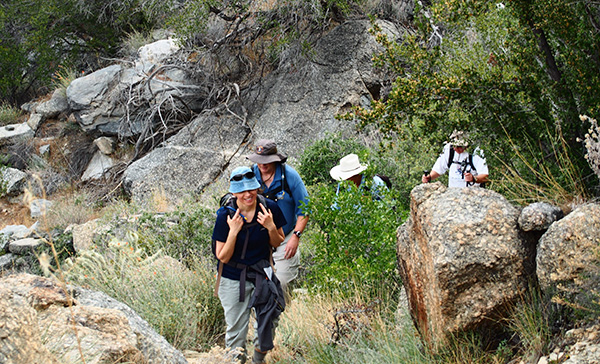
The first half mile of the summit trail is deceptively easy, with a fairly smooth and wide path that gently, but steadily, climbs toward the mountain. After that the trail becomes increasingly rough and rocky with larger step-ups and more maneuvering around larger and larger boulders, and it’s a steady climb for the next couple of miles. We look back from time to time to see how much elevation we’ve gained, and the view becomes increasingly expansive as we get higher on the trail, looking out over vast stretches of basin and range province marching out to the far horizon or the next mountain range. Less than thirty minutes from the trailhead, a dark band of large cumulus clouds moves in and completely covers the sun. For a while it’s a welcome relief from the intense rays of the sun, but as the cloud cover becomes increasingly thicker and darker we start to become concerned about the potential for a thunderstorm. Michael even remarks at one point that as soon as he hears any thunder or sees any lightning he will start heading back down. |
||||
 Rudy and Chuck navigate an easy stretch of trail. [photo by Quy] |
||||
 This crested saguaro is located just off the trail. [photo by Quy] |
||||
 Large cumulus clouds are rolling in fast now. [photo by Quy] |
||||
|
I totally agree, but also hope that we can trust the weather forecast, which wasn’t showing any rain at all for today. Really? Who the heck am I kidding anyway? How many times have we been caught completely by surprise on a hike because of a totally inaccurate weather forecast? Let’s see now ... there’s that infamous Mt. Humphreys hike, then who can forget that soggy Inner Basin hike, also the Wasson Peak hike some years back, then there’s that strange rim area hike a couple of years ago, then of course ... Well, you get the general idea anyway. |
||||
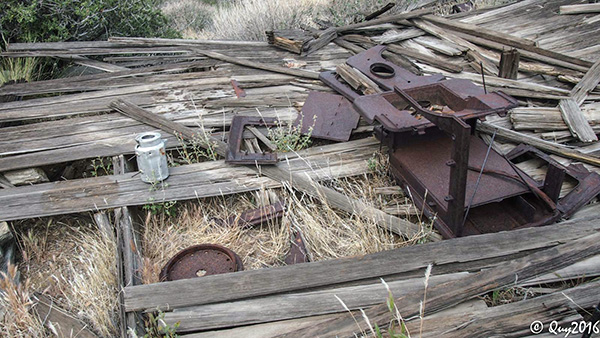
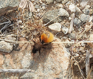 A colorful velvet ant navigates over rough terrain. [photo by Steve] I’ve been caught in several severe thunderstorms while mountain hiking over the years, and it’s quite a harrowing experience, not to mention potentially life threatening. One such experience a number of years ago just below the peak on Mt. Humphreys was particularly harrowing and threatening, and some of us were none too certain that we would make it out alive. But that’s another story for another time. Suffice it to say that more than a few hapless hikers have been struck and killed by lightening on or near Humphreys Peak over the years, as well as many of Arizona’s other highest mountain peaks. After several miles of hiking and steadily gaining some serious elevation, we discover what appears to be the remains of some long-abandoned structures, with gray and weathered boards and pieces of rusty corrugated tin scattered around in several different areas. There’s even a rusted and busted wood stove and a battered coffee pot among one set of ruins. The first set of boards actually sprawls right across the trail, and we have to carefully pick our way through since some of the boards still have large protruding nails, business end up. A puncture wound caused by accidentally stepping on one of these bad boys could be very bad and potentially result in a serious tetanus infection. |
||||
 Trailblazers continue to make their way up the trail. [photo by Quy] |
||||
 Around and around the switchbacks we go. [photo by Quy] |
||||
 This big boulder made a clean break for it. [photo by Quy] |
||||
 ... while this bad boy is going nowhere. [photo by Quy] |
||||
|
We soon come across the first of many interpretive signs along the trail, this first one discussing the history behind these old dilapidated structures. They were originally constructed as cabins for the miners and are all that remain of an old mining camp dating back to the early 1900s. The scattered lumber once served as their floorboards, while the walls and roofs were constructed of heavy canvas material with the corrugated tin probably used for extra reinforcement. |
||||
 We carefully pick our way through the lumber pile. Watch for those rusty nails! [photo by Quy] |
||||
 Ruins of a bygone era on the mountain. [photo by Quy] |
||||
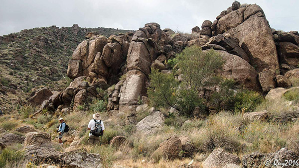 The higher we climb, the more rugged the terrain. [photo by Quy] |

|

|
| Camphorweed and Mariposa Lily. [photos by Quy] | |
|
Prospectors migrated here from surrounding areas in search of gold and silver in these mountains, as in so many other places across the west, but their efforts were completely unsuccessful and the camp was totally abandoned just a year or two later. We have to wonder if these particular prospectors eventually made their way southeast to the Superstitions in search of the Lost Dutchman’s gold mine. Or perhaps one day they migrated to the Bradshaws to the northeast where their chances of finding gold and silver were much higher and some miners actually struck it rich. But unfortunately for these men, there were no precious metals to be found anywhere in the Harquahalas. |
 An old water line runs parallel with the trail. [photo by Steve] |
|
From time to time we come across old sections of what was once apparently a water line that delivered drinking water to the summit. But more on that later. As we get higher on the trail, we also see large sections of the old jeep road that winds its way all the way to the summit. The last two miles to the top are the steepest, with numerous long switchbacks to make the going a little easier for us. But with nearly 3,400 feet of elevation gain to the peak and almost 1400 feet of that in the last mile or so, easier is an extremely relative term as we continue slogging our way up the trail and fighting for every few feet of elevation. Slowly but surely, we grind it out. But heat is definitely not a problem for us at this point, since the higher we climb on the trail the windier the conditions and those predicted 20 mph wind gusts are now slamming us with increased frequency as we struggle through the switchbacks and get ever closer to the peak. And at 5,681 feet, Harquahala is nearly 7,000 feet lower than Mt. Humphreys, so oxygen depravation and altitude sickness are certainly not factors on today’s hike. This trail is actually an excellent conditioning hike for those preparing to hike Mt. Humphreys, since the total round-trip distance and elevation gain are virtually identical to the Humphreys Peak Trail, minus the extreme elevation. |
 Trailblazers continue to slowly grind their way up the trail. [photo by Steve] |
 Anikó is in the lead along this stretch of trail. [photo by Steve] |
 Can someone tell me why we’re hiking when there’s a road to the top? [photo by Quy] |
|
We round one last switchback and spot a couple of our hikers in the distance on the final approach to the summit. But, like most trails to the top of a mountain, that last half-mile or so seems to go on and on into infinity and we wonder if we’ll ever get there. But we all eventually do get there, and six smiling Arizona Trailblazers are standing on top of Harquahala Summit at High Noon. We have finally reached the top of southwestern Arizona’s highest mountain peak. As an added bonus, there’s even a large metal picnic table near the top where we all park our gear and do a little exploring before we settle in for some lunch and a well-deserved rest break. |
 We made it to the mountain top! B’rrr — it’s cold up here! [photo by Quy] |
 Rudy provides the lunch time entertainment. [photo by Quy] |
 Looks like we have company on the summit. [photo by Quy] |
 Six smiling Trailblazers on Harquahala Summit. [photo by Steve] |
|
Primarily because of Harquahala Peak’s remote geographical location, mostly clear weather with high visibility, and its stature as the highest mountain peak in southwestern Arizona, in 1920 the Smithsonian Astrophysical Observatory Program, based in Washington, D.C., chose this site as the location for the Harquahala Peak Smithsonian Astrophysical Observatory. Construction was completed in August, 1920. Eight scientists and astrophysicists lived and worked year-around on this remote and rugged Arizona mountain peak from 1920 to 1925. Their main job was to study and analyze solar activity and to ultimately prove or disprove theories about the relationship between the sun and world-wide climate changes. The only remaining primary structure on the summit, a two-story building with corrugated metal siding and roof surrounded by a high chain link fence topped with barbed wire, served as both living quarters and laboratory for the scientists living on the peak. Living quarters, a kitchen, and offices occupied the upper floor, while the lower floor housed all of the instruments, equipment, and a workshop. All food, water, equipment, and supplies were hauled up the mountain weekly on pack animals, thus the reason for the trail sometimes being referred to as the Harquahala Pack Trail. |
 Explaining the story behind the observatory. [photo by Quy] |
 Chuck and Anikó study one of several interpretive signs on the summit. [photo by Steve] |
 The main observatory building. [photo by Quy] |
 Present-day microwave towers on the summit. [photo by Steve] |
|
Due to harsh weather conditions on the peak, both from heavy summer monsoon rains and sub-zero temperatures and often heavy snowfall during the winter months, the program managers eventually decided to move the observatory to a more suitable and comfortable location. So in late 1925 the Harquahala observatory was shut down and abandoned, and all the equipment, instruments, and the scientists were moved to Table Mountain in southern California. But as interesting and notable as all of this is, the one thing that we’ll all likely remember a year from now is the sighting of a very large gopher snake right on the summit, as seen in these two pictures. Anikó first spotted the big guy sunning itself in the cold wind, trying to get warm. Everyone gathers around snapping pictures, as the frustrated serpent reluctantly gives up on its sunbath and slithers off into the brush and rocks to escape all the attention. Most seem to agree that its length is close to six feet, with a girth of at least two to three inches at the thickest part of the body. This is one really big gopher snake, and I’m sure by the time this story gets repeated a few times, the snake will have magically grown into a legendary monster the size of an anaconda. |
 A large gopher snake makes its getaway. [photo by Quy] |
 The snake was how big? [photo by Steve] |
|
We finally head back down the mountain around 1:00 PM, and most of us reach the trailhead about 3:30. |
 A few colorful cactus blooms along the trail. [photo by Quy] |
 There’s a surprising number of flowers blooming today. [photo by Quy] |
 Six hungry Trailblazers at the El Ranchero in Wickenburg. [photo by Quy] |
|
Steve had earlier suggested a Mexican restaurant in Wickenburg that we drove by on the way to the trailhead this morning. So we all gather at the El Ranchero Mexican Restaurant in Wickenburg for a good post-hike meal and libations after a long and tough day of hiking. Much to our surprise, we discover that the owner is also the primary chef and entertainer by way of singing in Spanish for birthdays and other events at the restaurant. We’re serenaded with one such birthday song at a nearby table. A very busy and talented man with a rich and booming baritone voice. |
 Photographer Quy. |
 Top of Page
Arizona Trailblazers Hiking Club, Phoenix, Arizona
Comments? Send them to the AZHC .
updated April 12, 2019