Outdoor Links
Hike Arizona
Trip Planning Guide
Trip Report Index
Calendar of Events
Library
|
AZT 31 32 Day Hike Flagstaff July 15, 2017 by Dave French |
|
|
|
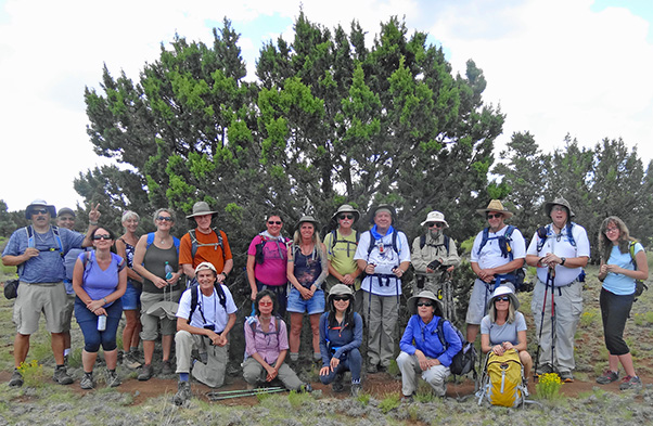
Dave M, Dubravka, Biljana, Romona, Sirous, Chris, Yanis, Michelle, Cecilia,
Debbie, Darrell, Li, Chuck, Jim, Heather, Mark, Dorinda, Michael, Emma. [photo by Dave F] |
|
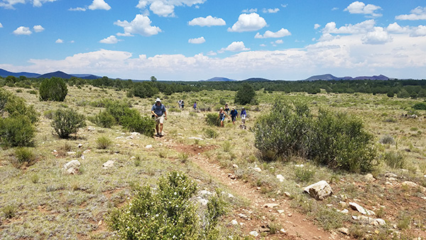
This hike was designed to fill in a big gap in my Arizona Trail accomplishment. It was quite successful. Sixteen hikers left Bell and I-17 at 6 AM and met four other hikers at the Mobil Station at I-40 and Country Club Drive in Flagstaff. Since this was a key swap hike, we swapped cars and got underway. The process of deciding which car goes to which trailhead is always a little confusing and time consuming, but we did it. For future reference, the FR 303 trailhead is along Old Walnut Canyon Road. You take Country Club Drive south from I-40, turn left at the Wyndham Sign, pass a pond on the right that has a lot of geese in it and continue on the unpaved portion for a couple of miles and look for the unpaved parking area on the right. The Sandy Seep trailhead is north on US 89, about a quarter of a mile north of the Townsend-Winona intersection. The small brown trailhead sign on the right says turn left onto an unpaved road that leads immediately to trailhead parking. Some of our drivers got a little confused finding the trailheads, but all made it in due time. We had ten hikers starting at each end of this section of the AZT. I started at Sandy Seep, hiked southbound and will describe the hike in that direction. After a quick group photo we took the connecting trail from Sandy Seep Trailhead to the Arizona Trail and turned left. The junction is well marked. The sky was clear and temperature in the 70s. The early part of the trail is nicely shaded and very gently rolling. We did find some open areas which had views of Mount Elden and the surrounding area. |
 Do not miss that turn. |
 The southbound group is ready to roll. |
 Off through the forest. |
|
After about 4 miles we came to a well-maintained unpaved road right where it made a 90° turn. We could not see an AZT trail marker to tell us which way to go. Michael decided to explore going right. I watched him go several hundred feet without seeing a trail marker, so decided to try going left. Sure enough, after a couple hundred feet, we spotted a trail marker and radioed to Michael. Going northbound through this section would not present the same dilemma, but I made a note to warn the northbound hikers when we met them. |
 Picture Canyon is worth a separate trip to explore. |
|
After crossing an open area, we could hear a westbound BNSF train chugging its way toward Flagstaff and eventually got a glimpse of it. We came to a sign noting that we are at the edge of the Picture Canyon Conservation Area. Apparently there are many petroglyphs in the area and is worthy of a visit in the future. We came to the flowing Rio de Flag, crossed on a wooden bridge, and continued our southeast journey on the AZT. |
 Some areas were more open than others. |
 One of several rock outcroppings. |
 Crossing the Rio de Flag. |
 Dave M. |
 Deer on the horizon. |
 Clouds begin to build over Mount Elden. |
 Lots of cinder mining at base of Mt. Elden. |
|
At about the halfway point of 6 miles, we met the northbound group right on schedule. After taking a group photo, hikers scattered to try to find something to sit on for a snack break. After a little rest, the two groups exchanged keys and continued on their respective journeys. The southbound group quickly encountered several cow pies on the trail and then saw the responsible beast. We continued on under the BNSF railroad and then the Cosnino underpass under I-40. |
 Trudging right along. |
 Packera fendleri - Fendler’s groundsel |
 Hikers scatter to find spots to sit for snacks. |
 Hmmm, this spot looks like it will do. |
 Here, you need something to drink. |
 The Arizona Trail passes under the BNSF railroad. |
 Cosnino underpass of I-40 westbound. |
 Beasts responsible for the cow pies. [photo by Li] |
|
South of I-40 is the Campbell Mesa area and is the most barren part of this hike. Once we crossed Walnut Canyon Road, we entered a much better forest and welcome shade for the rest of the hike to FR 303 (Old Walnut Canyon Road). I telephoned Jim leading the northbound group and he said they had just gotten to Sandy Seep Trailhead, so the timing was excellent. We drove back to the Mobil Station and met the northbound group. |
 Romona takes a break on Campbell Mesa. |
 Dubravka ventures across barren Campbell Mesa. |
 We’re on the home stretch now. [photo by Sirous] |
 Wooden sign at the FR 303 Trailhead. |
|
Six of the hikers departed for home and the other 14 went to OakMount Restaurant in the nearby Continental Country Club. I had phoned them when we reached the trailhead, so they had set up a table for 14 and accommodated us very well. Thanks to Jim for meeting the hikers in Phoenix and arranging the carpools and for leading the northbound group. See Jim’s supplement below. For future reference, the AZT website had this hike listed as 11.7 miles plus the 0.1 connecting trail from Sandy Seep Trailhead. My GPS measured almost exactly that. Michael’s measured over 12 miles and Jim’s even more, as recorded below. We can use Jim’s for statistical purposes. The hike took about 5.5 hours. We got some clouds by 11 AM but no thunder or rain. All in all, a very pleasant day with the maximum temperature about 85 degrees. |
|
Supplemental Report by Jim Buyens |
|
|
It was great seeing you all again yesterday! It was a great trail, everyone seemed to be enjoying themselves, and we even managed to dodge the rain. Jim |
 Michelle catches a good view of Mt. Elden. [photo by Li] |
 San Francisco Peaks, from the Arizona Trail. [photo by Darrell] |
 Volcanic cinder cone. [photo by Darrell] |
 Tiny cactus. [photo by Darrell] |
 Rio de Flag. [photo by Darrell] |
 Remains of early settlers. |
 Northbound Group |
|

|
||||||||||||||||||||||||||||||||||||||||||||||||||||||
 Top of Page
Arizona Trailblazers Hiking Club, Phoenix, Arizona
Comments? Send them to the AZHC .
updated July 18, 2017