Outdoor Links
Hike Arizona
Trip Planning Guide
Trip Report Index
Calendar of Events
Library
|
Buenos Aires NWR / Browns Canyon SW of Tucson April 1-2, 2017 by Dave French |
|

|
| Susan, Kim, Amy, KG, Rudy, Kari, Billie, Dave, Cyd, Jeanne, Michael, Sandy, Eileen, Barb, Mohammed, Yolanda |
|
This was a rare overnight, non-camping hiking trip by the AZ Trailblazers. We went to a portion of the state that no one in the group had ever been to, except the trip leader a month before. The area is southwest of Tucson, south of Kitt Peak, and we got within about 8 miles of the Mexican border. Buenos Aires National Wildlife Refuge is run by the US Fish and Wildlife Service and previously was a working ranch for many years. There are several buildings remaining from the ranch including the Visitor Center for the NWR. Additional lands were acquired near the town of Arivaca and also Browns Ranch to the northwest. All in all, the NWR extends from the Mexican border northward about 20 miles and is about 15 miles wide. I read about it in the March 2017 edition of Arizona Highways and decided to visit there in late February. I had previously read about a Browns Canyon hike in the area that is only open to groups on a reservation and guided basis, so I asked the resident ranger about doing that hike. He told me they have this rustic lodge called the Environmental Education Center (EEC) that is available to worthy groups on a reservation basis. I convinced him that the Arizona Trailblazers were not only worthy but also trustworthy. That is how I was able to book this place so we could make the long drive, do some hiking and spend the night before driving back. |
 Would you eat here? |
|
The EEC has room for 16 people to spend the night, so that set the maximum number for the trip. Sixteen of us met at 6:30 AM at Einstein’s on a cool Saturday morning and drove in six cars. We drove through Tucson, then south on I-19, made a needed stop at a rest area and then exited at Arivaca Road where we saw the world’s largest cow skull. Our first hike was just east of the Town of Arivaca on the Cienega Trail. It is flat, some paved, some board walk, and some dirt. The basic loop is about 1.4 miles but we added an out and back for a total of 1.8 miles. This is a birding area with lots of trees and some pools of water. We saw some birds, but birders have to be very patient and quiet. That does not fit 16 Trailblazers. |
 On the Cienega Trail. [photo by Mohammed] |
 A bog on Cienega Trail. |
 Bigger Bog on Cienega. |
 A Comfy Spot. |
 On the board walk down by the sea. |
 Flares dropped by military jets. |
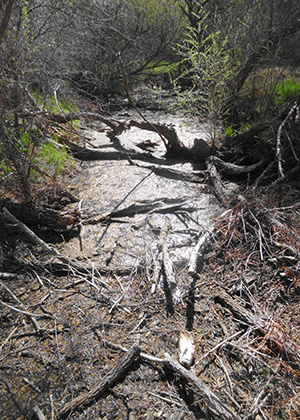
 Mariposa Lily. [photo by Mohammed] After this little leg stretcher hike, we drove through Arivaca and parked at the Mustang Trailhead just west of town. We headed down the trail through a thicket of trees and then had to cross a stream at a water flow measuring station. We continued on a trail that was very lightly used and sometimes hard to follow. After a while we dropped down into a wide dry creek bed and came to a barbed wire fence. There was a two track trail to our left so we took that up onto a mesa and passed a working ranch. We could see a Border Patrol tracking station ahead so we decided to bushwhack back down into the dry creek bed. We stopped for snacks and then continued down the creek bed and back to the barbed wire fence, crawled under and followed the trail back to our trailhead. |
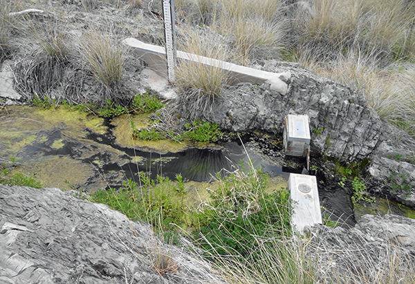 Water flow measuring gate. |
 Getting started on Mustang Trail. [photo by Mohammed] |
 Lots of Deer. [photo by Mohammed] |
 There’s a Pot of Gold. [photo by Mohammed] |
 Baboquivari Peak from the highway. |
|
We loaded up and headed west, about a quarter of a mile west, I noticed a much bigger and better signed trailhead and realized we had not been on the Mustang Trail at all. Oops, my bad. Oh well, we had a good adventurous hike anyway. We proceeded to the NWR Visitor Center to pick up the key to the EEC and to drop off the payment. The facility cost $280/night, or $17.50 each. Heck of a deal. We had to drive north on SR 286 for about 12 miles and turn left at an unmarked unpaved road. The road was not too bad and we got to a large residential building, tried the key with no luck. I had seen a picture of the EEC and did not think this looked right, but was surprised that there was another large building. I drove about a mile further and the road got rougher but I was OK in my Subaru. I came to another large building that looked like the right place, tried the key and it worked. I returned to the other building where the others had waited and advised that the three sedans, should not try going further, so we shuttled everyone up to the EEC. |
 Environmental Education Center. [photo by Eileen] |
 Dining Hall in the EEC. [photo by Eileen] |
 Upper level sitting area. [photo by Eileen] |
 Ladies enjoy time after the rain. |
 End of supper time. [photo by Cyd] |
|
We returned to the EEC, each prepared and ate their own supper, and then we build a fire and sat around enjoying each other and the setting. Rudy the Showman pulled out his guitar and provided us with absolutely great entertainment. Thanks, Rudy. |
 Billie’s pet jaguar. |
 Rudy croones a tune. [photo by Cyd] |
 Everyone is captivated. |
 We were an attentive audience. |
 Rudy at his best. |
|
What a great place! Yes, it is rustic but in a great setting and perfect for a bunch of rugged hikers. After settling in, it started raining, but we still wanted to drive back to the NWR Visitor Center and drive the 10 mile Pronghorn Loop Drive that is noted as a good place to see wildlife according to the Arizona Highways article. About half of the group decided not to go, so we loaded into two vehicles and headed out in a light rain. We had been on the loop drive less than a mile when a large herd of pronghorns thundered across the road ahead of us and another group turned and went the other way. With the rain, poor lighting, and speed of the herd, no one got a photo, but it was still great to see. We saw several groups of 3 or 4 deer along the way. As we drove the 12 miles north on SR 286, the clouds blew away and we got a stunning complete double rainbow over a sea of native golden grass. As we drove back up the 6 miles of unpaved road to the EEC, a mountain lion bounded out in from of us and quickly disappeared into some trees along a creek. As the driver of the lead car, I got a great view of it but not nearly enough time to get a photo. Most of the others were not in a position to see it. |
 Dave warms himself. [photo by Kari] |
 Sunrise. [photo by Yolanda] |
 Baboquivari Peak at sunrise. [photo by Yolanda] |
 Baboquivari Peak. |
 Mohammed chows down at breakfast. |
 Lots of stream crossings. |
|
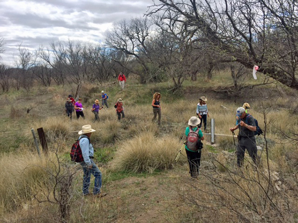
The next morning after breakfast we took a group picture with Baboquivari Peak in the background. We hiked the Browns Canyon Trail to the arch and then a shorter jaunt on the Jaguar Trail. We had to cross a flowing creek at least a dozen times, but it was not a problem. |
 Hitting the trail to the Browns Canyon Arch. |
 The group moves quickly. |
 Water flowing under the arch. |
 High tech remains of the old ranch. |
 Windmill. |
 Wheelbarrow got left behind. |
 View from under the arch. |
 Browns Canyon Arch |
 Outcropping near the arch. |
 Arizona Sycamore. |
 The group takes a break on the Jaguar Trail. |
|
A few of the hikers decided not to hike that morning so they stayed and cleaned up the EEC for us. We had to leave the place just as good as we found it. Thanks, Cyd and KG. We stopped in Robles Junction at the Three Points Restaurant for a late lunch. The food was good and it was quite a nice place for such a remote area. Combined on the three hikes we went 9.1 miles with a total elevation change of maybe 1000 feet. This was not your butt-kicker hiking venture, but we had a great time in a unique beautiful environment. We saw 2 coyotes, a herd of pronghorns, several groups of deer, a mountain lion, and a bunch of different birds. If I do this trip again, I would try it in early fall. We were too early for all the trees and grasses to green up, and I think the area will be much prettier after the summer rains. |
| → Rudy singing. |
 Top of Page
Arizona Trailblazers Hiking Club, Phoenix, Arizona
Comments? Send them to the AZHC .
updated April 4, 2017