Outdoor Links
Hike Arizona
Trip Planning Guide
Trip Report Index
Calendar of Events
Library
|
Dogie Trail Day Hike Sycamore Canyon Wilderness April 1, 2017 by Chuck Parsons |
|
 Arizona Trailblazers gather at the Dogie Trailhead. [photo by Quy] |
|
First Row: Dave, Quy, Mimi, Monika, Alan, Susan, Cecilia, Basma. Second Row: Biljana, April, Lin, Mary, David, Funyung, Carol, Yanis, Tamar. Third Row: Tom, Debra, Jen, Lance, Chuck. (Vicki and Stacy are not pictured.) |
|
As late as Friday morning, March 31, the day before the hike, I was becoming more and more convinced that the Dogie Trail hike was just not meant to be. Or, for those who believe in such things, it simply wasn’t in the stars, or the stars or perhaps even the planets were not properly aligned and thus not conducive to this club doing the hike. This hike was originally on the Arizona Trailblazers calendar for late September, 2016, before one of our hikers warned me that September was still too early for hiking in Sycamore Canyon and the heat would likely be overwhelming on the hike back out. So we moved the hike up to early November, 2016. Unfortunately, an early winter storm swept across northern Arizona just two days before the hike and dumped large quantities of rain across the entire area, including Sycamore Canyon and the Forest Service roads leading to the Dogie Trailhead. When I finally got through to the Red Rock Ranger District in Sedona for an update on road conditions, I was informed that the roads were a muddy quagmire and to not even attempt driving them. And forget AAA if you became mired down in the mud. So we rescheduled the Dogie hike for the second time to April 1, 2017. As I was checking the weather forecast for Cottonwood, Sedona, and the Sycamore Canyon area the week of the hike, chances for rain ranging from 30-60% were predicted for Tuesday thru Friday, with a 10% chance of rain for most of Saturday. And just as in November, one of the biggest concerns were the road conditions getting to the trailhead. Well, here we go once again. What to do now? Postpone the hike yet again, or damn the torpedoes and full speed ahead? I called my Sedona contact and our resident Arizona Trailblazers meteorologist, Mark Purcell, to get his esteemed and educated opinion on the situation. Mark informed me the Sedona area had only been receiving light sprinkles for the past few days, and his weather app showed the latest system moving out of the area by early Saturday. I also called the Red Rock Ranger District again, and they concurred with Mark on rain conditions. What a relief! Still, as an added precaution, just in case everyone was wrong and Murphy’s Law decided to prevail and slam us with a surprise, I decided to come up with a Plan B. Plan B was to attempt to reach the Casner Mountain Trailhead and hike to the top of Casner Mountain just in case we couldn’t reach the Dogie Trailhead. |
 We must be on the right trail now. [photo by Lin] |
 Sycamore Canyon Wilderness boundary. [Lin] |
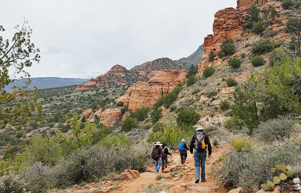 Arizona Trailblazers are on the move. [photo by Lin] |
 Carol and Alan admire the surrounding scenery. [photo by Tom] |
 ... while Biljana and Lin take a short break. [photo by Vicki] |
|
Thankfully, Plan B never had to executed since both FR525 and FR525C to the Dogie Trailhead look as if they never received a drop of rain over the past few days. Where the heck did all of that forecasted rain go anyway? Not our problem, since it apparently went elsewhere, probably much farther to the north. All of FR525 and much of 525C look as if they have both been recently graded and are about as smooth and level as one can hope for a Forest Service road. The last couple of miles of 525C do get a bit rough in places, with a few washed-out sections of road, but overall road conditions aren’t really too bad at all. We’ve certainly seen our share of extremely rough and primitive Forest Service roads over the years, some that don’t even resemble a road as we normally think of one and would actually be more suitable for a half-track or perhaps even a Bradley tank. After a few miles on these “roads”, kidneys and bladders have been jostled and jarred to the point where all vehicles are forced to stop from time to time to allow long-suffering passengers and drivers time to bail out and get up close and personal with nearby trees and bushes as quickly as humanly possible. The group mantra suddenly becomes very urgent — To the Forest or Bust! Ouch!. |
 The expansive Sycamore Canyon Wilderness. [photo by Quy] |
 Blue skies are beginning to show through the cloud cover. [photo by Lance] |
 The views just keep getting better. [photo by Quy] |
 Trekking down the Dogie Trail. [photo by Carol] |
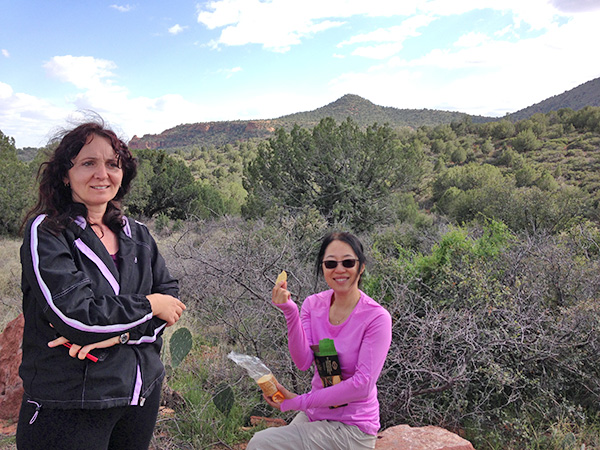
 Tamar and Basma in high spirits. [photo by Tom] |
 April brings up the sweep position in this group of hikers. [photo by Quy] |
 April and Tamar take a break. [photo by Vicki] |
 Time to shed a layer, as the sun breaks through. [photo by Carol] |
|
Our five vehicles pull into the relatively spacious Dogie Trailhead parking area that’s large enough to accommodate at least a dozen or more vehicles. Here, we link up with a sixth vehicle and two more hikers in our group. We finally have our full compliment of 24 hikers all together for the first time today. We get all our gear ready and lace on our hiking boots, as I pass out a few radios and Vicki passes out some trail maps. Then everyone gathers at the trailhead for a couple of quick group pictures for the record. Normally, our next step would be a round of introductions from all hikers, especially for the benefit of our newest hikers in the group. But some of these Arizona Trailblazers are chomping at the bit so hard that before I even know it several have already bolted from the starting gate and charged up the trail in a mad dash for the finish line. Really? The time is 9:45 AM on a gray and overcast Saturday morning on this April Fools Day of 2017, as the rest of the group charges up the trail in hot pursuit. Detail: forward march, double time! The temperature is a cool and pleasant 47 degrees, ideal hiking weather for all the climbing we’re going to be doing today on the Dogie Trail. This is a hike you definitely don’t want to be doing in the middle of summer. |
 This tree spreads its barren branches against a somber sky. [photo by Lin] |
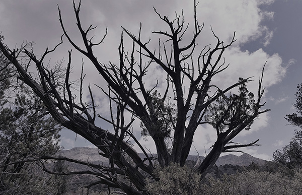
 This juniper has definitely seen better days. [photo by Lin] |
 Century plant with a bright red flowering stalk. [photo by April] |
 Yucca in full bloom. [photo by Lin] |
 Apple’s Flower. [photo by Quy] |
 Milkvetch. [photo by Quy] |
 Western Wallflower. [photo by Quy] |
 Indian Paintbrush. [photo by Quy] |
 These trees are loaded with tiny white blooms. [photo by Tom] |
 Close-up picture of a set of blooms. [photo by Lin] |
 Owl’s clover. [photo by Lin] |
 Wild onion. [photo by Lin] |
 Stemless Primrose. [photo by Lin] |
 Rock daisies. [photo by Lin] |
|
Not too far from the trailhead we gradually begin climbing up toward Sycamore Pass, a high ridge with expansive 360 degree views. Before long we pass through a heavy metal cattle gate, whose rusting hinges are groaning in agony and pleading for lubrication. Did anyone bring some WD-40 today? A little farther on and roughly a half mile from the trailhead we note a large weathered gray wilderness sign, marking the official boundary of the Sycamore Canyon Wilderness. Established in 1972, this is one of the oldest designated wilderness areas in Arizona, and Sycamore Canyon is the second largest canyon in the state, taking a back seat only to the mighty Grand Canyon. The Dogie Trail was also the designated “Hike of the Month” in the June, 2016 issue of Arizona Highways. The magazine describes the trail as “one of the most accessible and also one of the most beautiful of the 16 established trails in the 58,475 acre Sycamore Canyon Wilderness.” |
 Trailblazers continue to press onward toward Sycamore Creek. [photo by Quy] |
 April and Mimi admire the imposing red rock formations. [photo by Quy] |
 Taking time out for a short breather. [photo by Tom] |
A Rogue’s Gallery of Dogie Trail Hikers: |
 Tom and Carol above Sycamore Creek. [photo by Tom] |
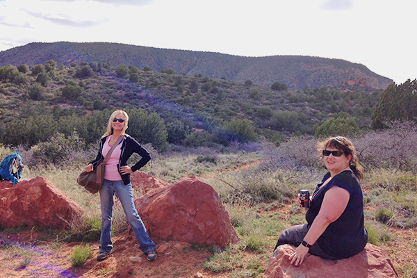
 Vicki is all smiles in Red Rock Country. [photo by Tom] |
 Funyung above Sycamore Creek. [photo by Tom] |
 Alan is deep in thought. [photo by Tom] |
 A penny for your thoughts, Carol? [photo by Tom] |
 Carol and Monika at trail’s end by the creek. [photo by Tom] |
 Time to regroup once again. If you’re not here, please speak up. [photo by Quy] |
 Photographer Quy photographs photographers Jen and Debra. [photo by Quy] |
|
Although this hiking club has done both the Sycamore Rim Trail and the Parsons Spring Trail on numerous occasions and the Kelsey-Dorsey Loop at least once, this is the very first time for the Dogie Trail. With 12 other exciting trails within the vast Sycamore Canyon Wilderness just begging to be scouted out, it looks like we've got a lot more exploring to do. Any takers among all you Arizona Trailblazers hike leaders out there? Hello? Anyone? |
 This massive sandstone shelf still has a small amount of flowing water. [photo by Lin] |
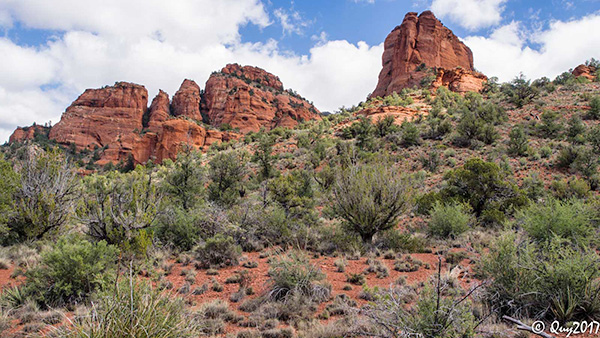
 Massive red rock formations soar high above the trail. [photo by Lance] |
 The views keep improving under increasingly blue skies. [photo by Quy] |
|
The Sycamore Canyon Wilderness is so large that it sprawls across three of Arizona’s National Forests: Coconino NF, Kaibab NF, and Prescott NF. Sycamore Canyon runs for over twenty miles along its namesake creek and in places stretches almost seven miles from rim to rim. The far northeast end of the canyon begins in cool forests of pine and Douglas fir on the southern rim of the vast Colorado Plateau, traverses down through the Mogollon Rim, and terminates at its far southwest end in the desert environment of the Verde Valley just to the north of the Verde River. With its colorful sandstone and limestone formations and the rich riparian habitat that flourishes along Sycamore Creek and its massive sycamores, cottonwoods, and walnuts, Sycamore Canyon is one of the most ecologically diverse and scenic canyons in all of Arizona. |
 White cumulus clouds add drama to this picture. [photo by Lance] |
 Rock climbers must love this tall formation. [photo by Quy] |
|
We soon begin a gradual descent through a forest of juniper, including some large alligator juniper, Arizona cypress, and pinion pine, before steadily gaining elevation on several long ascents and seeing increasing numbers of ponderosa pines along the trail. Although some sections of the trail, particularly in the low areas, are a little damp, it’s apparent that most of this area has not seen significant rainfall in quite some time. The surrounding scenery begins to look more and more like typical Sedona Red Rock Country, with impressive and colorful sandstone buttes, mesas, cliffs, and spires dominating the landscape. The deepest parts of the canyon preserve nearly 300 million years of geological time, all recorded in the multi-hued rock layers of the vast sandstone and limestone deposits. |
 This tiny cactus cluster has found the perfect environment. [photo by David] |
|
The trail starts to become rough and rocky, and we have to watch our footing very carefully to avoid tripping on the ever-increasing number of rocks, both large and small, covering the trail. About two miles from the trailhead we see a large vertical window set into a prominent mesa high above the trail. At first glance it's only a narrow slit in the rock, but as we get closer it gets wider and wider with the changing prospective. The trail gradually starts to become increasingly steeper as it dips in and out of a deep wash before eventually reaching another high ridge, offering a commanding view looking deep into Sycamore Canyon. From here we begin the long final descent that will take us all the way to the bottom of Sycamore Canyon and the waters of Sycamore Creek. |
 The Window. [photo by David] |
|
Before long we catch our first glimpse of Sycamore Creek, a slender pale green ribbon still hundreds of feet below the trail, as it threads a long serpentine passageway along the bottom of the canyon. The creek is normally dry for much of the year, but because of an unusually wet winter and spring this year it continues to flow. The only perennial source of water in Sycamore Canyon is located at its southernmost end, where Parsons Spring feeds a four-mile stretch of the creek year around. The Parsons Spring Trail is one of the most beautiful and scenic riparian hikes in Arizona and a long-time favorite of this hiking club. |
 Sycamore Creek winds its way along the canyon floor. [photo by Lance] |
 Second view of Sycamore Creek. [photo by Quy] |
 Low-hanging clouds dominate the skies above Sycamore Creek. [photo by Basma] |
 Then the sun temporarily breaks through for Nature’s light and magic show. [photo by Quy] |
 Tom stands next to his favorite boulder. [photo by Carol] |
 ... while Alan is thinking about going for a swim. [photo by Carol] |
 A large sand bank along the creek. [photo by Lance] |
 A sudden gust of wind ripples the water surface. [photo by Tom] |
|
Most of the group finally reaches Sycamore Creek around 12:30 or a bit later. Although there’s not much flowing water in the creek bed, or at least none that we can readily see, large pools of clear water and plenty of large inviting boulders provide the ideal location for a well-deserved lunch break. So everyone picks out their favorite boulder and sits down to lunch in one of the most scenic locations imaginable. It’s going to be very difficult to leave this place behind. Trailblazers gather for lunch next to the creek: |
 [photo by Basma] |
 [photo by Carol] |
 [photo by Quy] |
 [photo by Lin] |
 [photo by Tom] |
|
But after a half-hour or so, unless we’re all prepared to spend the night by the creek, we’re forced to leave this idyllic spot next to Sycamore Creek and slowly make our way back to the trailhead. |
 Trailblazers on the long trek back to the trailhead. [photo by Quy] |
 Hiking out of a canyon is always tougher than hiking in. [photo by Quy] |
|
The original goal for this hike was to reach the junction with the Sycamore Basin Trail, roughly another quarter-mile up the opposite side of the canyon. But since it’s already well past 1:00 in the afternoon and we have a good 3.5 hour trek back to the trailhead, I suggest to everyone that we begin to make tracks out of this canyon and back to our waiting vehicles. Besides, the creek is as good a turnaround point as any. We take in one last view of the red rock formations as we leave Sycamore Canyon. |
 Red rock formations. [photo by David] |
 Red rock formations. [photo by David] |
 Red rock formations. [photo by David] |
 Trailside flowers. [photo by David] |
 Trailside flowers. [photo by David] |
 Trailside flowers. [photo by David] |
 Trailside flowers. [photo by David] |
 Trailside flowers. [photo by David] |
 Trailside flowers. [photo by David] |
|
The time is almost 4:30 PM by the time we all arrive safely back at the Dogie Trailhead. Under mostly cloudy skies, the temperature stands at a pleasant 65 degrees. GPS readings indicate a total of 11.0 miles round trip to Sycamore Creek and back, with a total accumulative elevation gain of almost 2,200 feet. This hike turned out to be a bit more challenging than most of us anticipated. Unfortunately, most of the hiking information out there typically does not provide accumulative elevation gain, but instead only net elevation gain which can be very misleading on a hike like the Dogie Trail with its many ups and downs. |
 We made it back to the trailhead with daylight to spare! [photo by Tom] |
 Waiting for the last hikers to arrive. [photo by Vicki] |
 Plaza Bonita Mexican Family Restaurant in Cottonwood. [photo by Tom] |
 I’m getting hungry just looking at this picture. [photo by Lin] |
 Basma prepares to dig into her tasty meal. [photo by Lin] |
 Yum! [photo by Lin] |
|
After the trail dust is brushed off and all gear is stowed away, we’re ready to tackle FR 525C once again, as we carefully make our way back out to Highway 89A and Cottonwood. Most of us head to the Plaza Bonita Mexican Family Restaurant in Cottonwood for a late lunch/early dinner, while several others opt to head back to Phoenix instead. We’ve stopped at Plaza Bonita several times in the past. The food is very good to excellent, the staff is quick and efficient, and they’ve always been able to serve a large and somewhat rowdy crowd of ravenous Arizona Trailblazers. Despite the dire weather predictions and concerns over road conditions to the trailhead, this has turned out to be a perfect day for hiking and everyone was up for the challenge. Great job, Arizona Trailblazers! |
 Top of Page
Arizona Trailblazers Hiking Club, Phoenix, Arizona
Comments? Send them to the AZHC .
updated April 14, 2017