Outdoor Links
Hike Arizona
Trip Planning Guide
Trip Report Index
Calendar of Events
Library
California
March 3-7, 2017
by John M. Richa
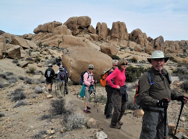
 Trailblazers at Joshua Tree National Park. |
|
My hopes to achieve by this trip report that it will not only describe our camping trip to Joshua Tree National Park (henceforth “park”) but will also serve as a descriptive story of what this park is all about, its history, its geological evolution, its fauna and flora etc. I would like it to be an informational and educational story not just for us Trailblazers participants who experienced this wonderful and enriching adventure, but also for those visitors who visit our beautiful website and hopefully take part in our weekly local hikes as well as our out of town trips, and those future hike leaders who might be inspired to revisit this park. What’s in the name?The park is located 250 miles west of central Phoenix, AZ., skirting I-10 that leads you to Los Angeles. L.A. is only 140 miles west of the park. See the Park Map. |
 This must be the way ... [photo by John] |
 It is! Here’s the park entrance. [photo by John] |

The inside of the Joshua tree is fibrous and it has no growth rings, which makes it hard to know how old the tree is. But some researchers think a typical life span for a Joshua tree may be 150 years. Due to the current draught, the Joshua tree is in danger of extinction. Less available water means fewer young Joshua trees can grow. According to legend, Mormon pioneers considered the branches of the Joshua trees (yucca brevifolia, an agave plant) to resemble the up-stretched arms of the Biblical Joshua leading them to the Promised Land. See the Hebrew Bible’s Book of Joshua, also in Numbers 13:1-16. |

|

|
| Joshua trees. [photos by Wayne] | |
 Yes, we all made it here. [photo by Quy] |
|
In the 1930s Minerva Hoyt, a community activist and desert-lover, recognized the threats from humans. She saw beauty in the spiny plants and slithery creatures where others did not. She persuaded President Franklin D. Roosevelt to proclaim Joshua Tree National Monument in 1936. In 1994, as part of the California Desert Protection Act, Congress renamed the area Joshua Tree National Park. Thanks to the efforts of Hoyt and others, this park protects 792,510 acres, more than 80 percent of it managed as wilderness, where the Mojave and Colorado deserts converge. Deserts don’t have firm boundaries, and much of the park lies in the overlap between the Colorado Desert to the east and the Mojave Desert to the west. This transition zone has a wealth of biological diversity and is home to more than 250 bird species, with unique characteristics of each of the deserts ecosystems. The park lies along a major migration corridor, and its proximity to the Salton Sea, the Pacific Ocean, and the Gulf of California explains why one might see a fish eating bird like an egret, or a yellow Oriole, or a large black turkey vulture soaring along the thermals without once flapping its wings. One might also see a hawk, a falcon and eagles circling high overhead. Here are some other common animals found at the park: the big horn sheep, the Chuckwalla, cactus wren, beavertail cactus, Greater roadrunner, black tailed jackrabbit, Gambel’s quail, desert tortoise and the desert iguana. The rattlesnakes were still in hibernation as of early March, because the constant temperatures have not risen yet above 50 degrees. At night the temperatures dropped to 30 degrees and we all felt it at the campground! On my exploratory visit to the park in December of 2016, I encountered a friendly roadrunner at the visitors’ center parking lot. |
 Roadrunner. [photo by John] |
 Jackrabbit. [photo by Wayne] |
|
At the Colorado Desert where our Cottonwood Springs campground is located, typical Sonoran desert plants are found, such as the jumping Cholla, the Ocotillo, the Palo Verde, Smoketree, the brittlebush and many more. Two weeks before our arrival, the park got a heavy dose of rain showers but the plants were still not in full bloom yet. Our campground is located at the southern end of the park, just 10 miles north of I-10, in the Colorado Desert half at an elevation of 3,000 feet above sea level. Because the campground was so isolated, it was described as the best place to do star gazing. Everything around us was pitch dark. Here is a picture of the skies as seen from our campground. |
 Stars blazed overhead. [photo by Wayne] |
 Don’t those buds look yummy? [photo by Quy] Joshua tree grows in height at a rate of about one inch per year. In the early spring season, i.e. between February and April, it blooms in a cluster of cream colored flowers. We were fortunate to be at the park at the right time for the tree blossoms. Tree branching occurs after flowering. |
 Everyone smile for the camera. [photo by Quy] |
 Silhouette of a Joshua tree before the clouds. [photo by Quy] |
 A bird in the hand is worth two in the bush. [photo by Quy] |
 Snowcapped mountains on the horizon. [photo by Quy] |
 Snowcapped mountains on the horizon. [photo by Quy] |
 This old tree has seen a lot. [photo by Quy] |
|
Now that we all have some ideas of the park, I will embark myself on narrating our camping trip. As we go through our activities, you will see lots of pictures taken by various trip participants and when available, I will interspace the pictures with known geological and historical factors about the scenes so as to give them a greater meaning. Our Arizona Trailblazers Hiking Club usually sponsors at least two out of town camping trips per year within one day’s driving distance or 500 miles away from Phoenix. We have undertaken several times such trips to the North Rim of the Grand Canyon, and South Rim, Zion and Bryce National Parks in southern Utah, Arches in north eastern Utah, the Chiricahua National Monument in southeastern AZ, the White Mountains in eastern AZ, and Death Valley National Park in southern California etc. Last time, and maybe the only time Joshua Tree National Park was visited by our club, was in April of 1997, 20 years ago. That alone prompted me to consider this trip in 2017. A short trip description was circulated to the club members to gauge the level of interest for such a trip and, unsurprisingly, because we all love these out of town camping trips, there was an overwhelming interest. At first glance, I had 48 would be participants. That necessitated a group camping site so that we can all be together for our activities and pot luck dinners etc. These camping sites must be reserved one year to the date in advance. Along with the availability of the sites, a suitable date must also be chosen, while all along being mindful of the weather. According to park information, the most ideal time is February and March where the temperature would range between 46 and 70 degrees Fahrenheit. This was the most ideal time of the year. During the summer, the temperatures could reach 100 degrees or more and in such high temperatures hiking becomes more difficult and dangerous. After a quick check of the park’s calendar, we found that early March was ideal and available. Perfect timing. Although there were several campgrounds in the park, only three had group sites. The park had limited water availability and had no shower facilities anywhere. Of the three group sites, Cottonwood Group, located at the extreme southern end of the park had running water and flush toilets. Others did not have such facilities. Although this would mean one hour of travel time every day to the middle of the park where all of our hikes will take place, the location nevertheless, put us close to I-10 for ease of arrival and quick exit. Most importantly, the flush toilets and running water were our biggest bonus and worth the driving to the park three mornings in all. Have you tried “vault toilets” before? Enough said! I will withhold my comments about vault toilets! At first, the trip was supposed to be only for would be campers but, because of popular demand, the trip was subsequently opened for hotel stayers. Hence, two side by side group camping sites, for up to 35 campers, were selected. Typically, when a trip is first proposed, many hikers get onboard. But in the span of one year, peoples’ circumstances change and seeing a 15 to 20 percent drop off in participation is normal. The final count of participants was 35 of which, two stayed in a hotel in Twentynine Palms, at the north end of the park, and nine members stayed in Indio, CA., located some 25 miles to the west of the park’s entrance off I-10. My first instincts and concerns were: logistical problems! Could our three group locations hikers be prompt every morning at a designated time and place? We had several days of daily packed activities and a tight schedule and any misstep could throw off the best laid plans! Furthermore, there is no cell reception in these parts. Unforeseen delays or someone’s car problem could throw off the day’s activities! Luckily, these concerns were quickly dashed away when two responsible hike leaders emerged namely, Sally and Sandy who insured me that their respective groups under their leadership and guidance would be timely every morning. And they certainly were. Thank you ladies. Once everybody paid their tent site fee, there was a long hiatus of nothing happening for 9 months. Three months before our due date, we restarted the planning effort. We developed two carpools configurations: one for the drive from Phoenix to the park and one in the park itself. We were advised by the park rangers to have as few cars as possible because the trailheads have small parking lots. Furthermore, what made it even worse, since our trip date fell on a weekend; it coincided with the California school systems spring break during which time, thousands of students flock to the park. We hence had to consolidate our carpools. Once the carpools were firmed up, our next endeavor was to develop the menu for the potluck dinners and the need to contribute various kitchen items such as folding tables, propane fueled camping stoves, paper supplies, firewood, jugs of water etc. The food menu was diversified and was supposed to last for two nights of dinners. As usual, we all over prepare and we had enough food for three nights. The meu was quite diversified and delicious. While we all enjoy the camping experience, the fellowshipping, the partaking in the community meals and enjoying the evenings around a warm fire, our main purpose on such a trip is hiking. To that effect, a concise and full 5 days itinerary was developed and flawlessly executed as planned. The following are our planned activities by the day. |
|
Friday, March 3, 2017
Check in time at the campground was 12:00 noon. Throughout the afternoon, various carpools checked in. First stop was at the Visitors Center to visit the small displays of pictures and articles of souvenirs about the park and pick up a park map. Cottonwood campground was just half a mile around the corner. Besides the three group sites, there were 62 additional single sites. At the group sites there were several ramadas that provided us with shade, picnic tables and fire pits. The rest rooms were nearby. See Campground Map. As various carpoolers arrived, it was time to select a site for one’s tent. Early birds get to do the picking. |
 Start with the Visitor Center. [photo by John] |
 There’s plenty to see here. [photo by John] |
 I live here, and it’s fine. [photo by John] |
| Signs at the Visitor Center: [photos by John] | |

|

|

|

|
 Group Site 2. [photo by John] |
 Group Site 1. [photo by John] |

|
 Sure, we have a shaded picnic area. [photo by John] |

|

|
| Hmmm, this looks all right to me. [photos by John] | |
| Setting up camp: [photos by Wayne] |

|

|

|

|

|
|
Joe was the luckiest of the campers. He drove his motor home and slept in it in full comfort. But he also offered us to keep our food coolers in his motor home for safe keeping lest the desert critters get in them had they stayed in our tents. Thank you, Joe. |
 Now I’m traveling in style. [photo by Wayne] |
 All the comforts of home. [photo by Wayne] |
 Standing watch. [photo by Quy] |
Those who arrived early and would like to do the first hike on the schedule could do so by hiking the 2.4 miles round trip to Mastadone Peak. A rock scramble takes you to the end of the trail to a craggy granite peak with great views to the horizon. The trail begins at Cottonwood Springs, where you can see tall and beautiful California Fan Palms and where the Cahuilla Indians used this spring for centuries. When they abandoned this area, they left behind remnants of their culture: bedrock mortars and broken pottery. Later on prospectors, miners, and teamsters established gold mills. The following are the pictures taken by these early hikers: |
 I’ll take you up, up, up to the top. [photo by Wayne] |
 This section of trail has a guard rail. [photo by Quy] |
 The rocks are like stair steps. [photo by Quy] |
 This is a great place to explore. [photo by Quy] |
 Watch your step on the way up. [photo by Quy] |
 Our two spotters! Anything out there? [photo by Quy] |
 Sure looks like the top to me. [photo by Quy] |
 Walking among the boulders. [photo by Quy] |
 Looking good on the way down. [photo by Quy] |
 Group picture after the hike. All hikers accounted for. [photo by Quy] |
|
By late afternoon everyone has checked in and it was time to eat dinner. This first night everyone was for himself. There was no shortage of fancy cooking though. All meals were accompanied by wine and beer and even special brews. After dinner we all gathered around a fire pit to socialize. The evenings were quite cold and at times windy. We all were bundled up. Arizonans, especially those living in the valley, are not accustomed to cold nights. Rudy seemed most knowledgeable on how to start a fire, although sometimes he had to get on his knees for supplications to start the fire. |
 What a fine day we’ve had! [photo by John] |
 I’ve worked up an appetite. [photo by John] |
| Bring on the food! [photos by John] | |

|

|
 Rudy and Kim enjoy their dinner. [photo by John] |
| We have the finest cooks. [photos by John] | |

|

|
| Wayne shows us how it’s done. [photos by Quy] | |

|
|
 Supplications to start the fire. [photo by John] |
||||||
 Let me tell you about the time ... [photo by John] |
||||||
 The fire is so inviting. [photo by John] |
||||||
 You don’t suppose there are any ghosts around here ... [photo by Quy] |
||||||
 The end of a perfect day. [photo by Quy] |
||||||
|
Ten o’clock was curfew time at the campground. Many of us had already retired for the night. The nights were clear and crispy cold especially after leaving the warmth of the pit fire. With the change in temperature in the desert where the earth’s crust gets colder than, say, a body of water, there is usually an exchange in wind speed. Cold air, being heavier than warm air, descends to the earth’s surface and the warm air rises into the upper atmosphere. This air circulation creates windy conditions. Later on at night, the exchange is over and the wind becomes still. Between 5:00 AM and 6:00 AM campers start to stir in their sleeping bags. Some of us were very early risers. At six o’clock in the morning the temperature was 30 degrees. Hot coffee was the order of the morning. People prepared their breakfasts and packed their backpacks for the day. Snacks and lunch will be on the trails. |
||||||
|
Saturday, March 4, 2017
At 8:00 AM we gathered at the center of our campground for a quick review of the day’s itinerary and for a group picture. Indio’s hotel stayers were prompt. We would meet Sally and Alice at Skull Rock Trailhead. After the photo shoot we had a quick name introduction and reported to our pre planned respective park carpools. The carpools worked flawlessly every day. Thank you, hikers, for a superior effort. |
||||||
 Now here’s where we’re going today. [photo by Quy] |
||||||
 Everyone gather around and listen. [photo by Wayne] |
||||||
 Trailblazers, all together now. [photo by Wayne] |
||||||
|
||||||
|
At 8:30 AM we started our one hour drive to the park’s center, where we would visit Skull Rock, probably the most visited and photographed scene. You will soon see why in the following pictures and why it was called “skull rock”. The road in the park was well paved but very meandering with posted speed limits between 25 and 45 miles per hour. At that speed it would have taken us 1.5 hours to get to our destination. Luckily, we never got stuck behind a slow RV. Needless to say, we sped way above the posted speed limits and we can report that none of us got ticked for speeding. Drivers, thank you for keeping up with me! The drive north was nondescript. The Colorado Desert portrayed the typical barren mountains, with brown, chocolate and sandy rock coloration and typical flora vegetation such as Brittlebush, Jumping Cholla, Ocotillo, Smoketree, Palo Verde and the abundant and dominant creosote bush. But suddenly and out of nowhere, the Joshua tree appears. We are now at 4200 feet above sea level and it seems as if someone drew a line in desert: we enter now the Mojave Desert. This was reminiscent of the Saguaro cactus in AZ: at a certain altitude, and without notice, it suddenly stops appearing on the landscape. |
||||||
 Boulders and Joshua Trees adorn the landscape. [photo by John] |
||||||
 The distant mountains are snowcapped. [photo by John] |
||||||
 Sentinels of the Mojave Desert. [photo by John] |
||||||
|
The first stop is Skull Cap, probably the most photographed rock in the park. Of course everyone wanted to pause in the picture: some liked being in the nose, others in the mouth or on the chin, or wherever they could find a suitable pose. We found plenty of parking spaces along the road. Here we met Sally and Alice, who comfortably stayed the night before in a hotel in 29 Palms. Our group of 35 hikers is now complete. Cameras were clicking away dozens of pictures. We even did some rock climbing at this location. There were great views of rock formation from on top. |
 Skull Cap. [photo by Wayne] |
 Now this doesn’t itch at all. [photo by Darrell] |
 Let’s explore the area. [photo by John] |
|
Now we were ready for our first hike: Skull Rock loop, a 1.7 miles easy hike. After a short “false start”, we found our bearings and the hike proceeded smoothly. Along the way, one could see many forms of unique looking rocks, forms and shapes, some spread out in piles and others stacked up. There were huge eroded monzogranite boulder formations which are world renowned natural features that provide unique aesthetic, educational, and recreational opportunities, such as rock climbing and high wire stunts. We will see these boulders and rock formations throughout our hikes at the park. |
What amazing rocks! [photos by John]
|

|

|

|

|

|

|

|

|

|
| High wire acrobatics. [photos by Monika] | |
 Trailblazers admire the view. [photo by Quy] |
 Interpretive sign. [photo by John] |
|
When you see these rock formations you become mesmerized and in awe! You wonder maybe “what are they?”, ”where did they come from?” or “what’s with all these strange shapes?” Here is a quick lesson in geology 101: What are they?Many visitors think that the rocks look like layers of sandstone, but they are actually a kind of granite, not unlike the rock commonly used for countertops. Granites are igneous in origin, meaning they formed when hot molten fluids within the earth’s crust gradually cooled into hard rock. Most granite in the park is of a particular type called “monzogranite”. The park’s monzogranite solidified beneath the surface of the earth starting about 245 million years ago, with the youngest rocks formed over 100 million years ago. Where did they come from?About 250 million years ago – before the dinosaurs came to dominate the planet – the thick North American plate began riding over the thinner Pacific Plate. The water-rich oceanic plate was forced under the continent at an angle. Water at depth, where temperatures are extremely hot, helped to melt the rock into granite magma. It was hot, liquid, and lightweight, and was able to ooze upward along deep-seated cracks in the crust that had been fractured by the fierce crunching of the charging plates. The liquid granite could not force itself all the way up to the surface, so the granite stalled and formed huge, ball shaped masses within the ancient rock. Over a long period of time, the great blobs of granite cooled and hardened. The ancient rock, called gneiss (pronounced “nice”), began to erode. Over millions of years, the gneiss has completely vanished from the surface in most of the park. The gneiss, dark in color, does remain exposed on mountain tops. Younger and lighter colored monzogranites are to be found in the valley bottoms. What with all these strange shapes?In many places in the park, the boulders appear as if some gigantic child piled them up. Some boulders have carved faces, are shaped like animals, or other fanciful forms. Your imagination is the limit. Cracks in the rocks and water are the keys to the appearance in the rocks today.Horizontal stresses from the collision of tectonic plates created sets of parallel, vertical fractures within the buried rock. Later, mountain building pushed the rocks upward to from sets of X shaped cracks standing at angles in the granite. All the fractures were avenues for rain water to seep downward through the rocks to etch and shape and round the originally angular blocks into the varied forms seen today in the park. The geologic landscape of Joshua tree has long fascinated visitors to this desert. How did the rocks take on such fantastic shapes? What forces sculpted them? |
Here are some examples: [photos by John]
|

|

|

|

|

|

|

|

|

|

|

|

|

The monzogranite developed a system of rectangular joints. One set, oriented roughly horizontally, resulted from the removal, by erosion, of the miles of overlying rock, called gneiss (pronounced “nice”). Another set of joints is oriented vertically, roughly paralleling the contact of the monzogranite with its surrounding rocks. The third set is also vertical but cuts the second set at high angles. The resulting system of joints tended to develop rectangular blocks. (figure 1) Good examples of the joint system may be seen at Jumbo Rocks, Wonderland of Rocks, and Split Rock. As ground water percolated down through the monzogranite’s joint fractures, it began to transform some hard mineral grains along its path into soft clay, while it loosened and freed grains resistant to solution. Rectangular stones slowly weathered to spheres of hard rock surrounded by soft clay containing loose mineral grains. Imagine holding an ice cube under the faucet. The cube rounds away at the corners first, because that is the part most exposed to the force of the water. A similar thing happened here but over millions of years, on a grand scale, and during a much wetter climate. (figure 2) After the arrival of the arid climate of recent times, flash floods began washing away the protective ground surface. As they were exposed, the huge eroded boulders settled one on top of another, creating those impressive rock piles we see today. (figure 3) Of the dynamic processes that erode rock material, water, even in arid environments, is the most important. Wind action is also important, but the long-range effects of wind are small compared to the action of water. The erosion and weathering processes operating in the arid conditions of the present are only partially responsible for the spectacular sculpturing of the rocks. The present landscape is essentially a collection of relict features inherited from earlier times of higher rainfall and lower temperatures. During the last Ice Age, the climate was cooler and wetter; rainwater was abundant. Much of the water etching occurred then. No glaciers existed this far south at these elevations, so glaciers were not a factor in making the landscape we see today. All of the above explanations will be evident to you in the pictures to follow as we hike from one trail to the next. We complete the 1.7 mile Skull Rock and proceed on to hike the adjacent two trails, namely Face Rock and then Split Rock a 2.8 miles loop hikes. |
 Yes, I can see you. [photo by Carol] |
 Another rock with a face. [photo by Carol] |
 No bears in this cave. [photo by Darrell] |
 The great stone gorilla. [photo by Sally] |
 A cracked rock. [photo by John] |

|

|
| These rocks are cracked, I say. [photos by John] | |
|
Trailblazers on the march. Note the beautiful landscape, rocks and plants: |

|

|
| Sure signs of progress. [photos by John] | |
|

|

|

|

|

|

|

|
 Trailblazers on the march. [photo by Quy] |
|
At the conclusion of this hike, we all take a well-deserved lunch break. It is already noon time. Hikers perched themselves on various rocks and savor their lunches and treats. |
 A boulder that split. [photo by Quy] |
 Lunch break. [photo by Carol] |
 Lunch break. [photo by Carol] |
 Jim and John conferring. [photo by Carol] |
|
After lunch we drive down the road to our next destination: Ryan Mountain, a 2.8 miles round trip hike, a challenging one not only by its steep ascent but also by the many steps one will need to climb over. Although climbing was challenging enough, descending these steps is harder on your knee joints. Some of us wisely decided not to attempt this hike. They experienced a fun surprise at a nearby 0.5 mile long trail and a beautiful looking rock formation called Hall of Horrors. |
 This is the trail. [photo by Wayne] |
 Ryan Mountain, here we come. [photo by Quy] |
 Fancy cairns, stacked precariously. [photo by Quy] |
 We topped out on Ryan Mountain. [photo by Wayne] |
 The view from the top. [photo by Wayne] |
 The view from the top. [photo by Quy] |
 We’ve done a lot of climbing. [photo by John] |
 Silhouette of a Joshua tree. [photo by Quy] |
 Trailblazers start back down. [photo by Wayne] |
 The way to Indian Cave. [photo by John] |
 Folks used to live here. [photo by John] |
|
While some of us, hardy hikers were attacking Ryan Mountain Trail, several of the hikers decided to hike a short distance to the Hall of Horrors rock formation. Instead of hiking the 0.5 mile loop trail they were treated to an aerial show, a high wire daredevil acrobat attempting to cross a space between two tall rocks on a windy afternoon. The daredevil was wisely tethered though for his own protection and you will see in the pictures to follow that he lost his balance and fell. No harm was done though! He climbs back up and continues on his tight rope walk. |
 A high wire daredevil acrobat. [photo by Mimi] |
 Derring-do? I say derring-don’t. [photo by Monika] |
 Oops! [photo by Monika] |
 He climbs back up. [photo by Monika] |
|
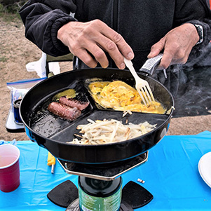
Our daily goal was to stop our activities around 4:00 PM and return to base camp. It is one hour’s drive back. By then, we are all hungry and full of anticipations of a delicious potluck dinner. What’s on the menu folks? Here’s a memory test for you all: can you name all these hungry hikers? |
 Chow time. [photo by Wayne] |
 There’s plenty for everyone. [photo by Wayne] |
 Help yourself. [photo by Wayne] |
 Kim knows what’s good.[photo by John] |
 I make them just right. [photo by John] |
 Heavenly. [photo by John] |
 What a feast! [photo by John] |
 Pabst Blue Ribbon time. [photo by John] |
 Rocks hold down the table cloth. [photo by John] |
 This is the life. [photo by John] |
 Enjoying the repast. [photo by John] |
 Rudy knows how to get the fire started. [photo by John] |
 desert temperature chart After the “dining hall” cleanup, we gathered around a pit fire. Some of the participants volunteered to bring fire wood and we had plenty of it to last us through our stay at the campground. Sometimes it takes skills to start a fire although we did not need a flint stone; nevertheless we had to get the fire going. Even Rudy, our preeminent outdoorsman, had some difficulty getting the fire going. He had to get on his knees and with some supplications he finally gets the fire going. The fire definitely provided warmth but also we inhaled lots of smoke and it is not the smoke you might be thinking of! Some drank beer, or wine or a hard brew. We played games, told jokes and stories etc. It was nice gathering around the fire as a group and relax. Gradually, one by one retired to their respective tents and by ten o’clock, it was curfew time: everybody was well tucked in their sleeping bag with tons of blankets and other clothing because the night was very cold and windy. Suddenly, the laughter around the fire pit turned into an eerie quiet. You could only hear the wind howling. Someone said they heard snorting noises of javelinas. |
 Let’s all gather around the campfire. [photo by Wayne] |
 Half moon rises over Joshua Tree National Park. [photo by Wayne] |
 The stars blaze over our campground. [photo by Wayne] |
|
This concludes our first full day and night at the park. |
|
Sunday, March 5, 2017
Again, around five or six o’clock in the morning, campers start to stir in their sleeping bags. Time to get out of this cocoon and smell the coffee and eat a hot breakfast. Today is Sunday, our second full day at the park. We will be visiting Keys Ranch and do four nearby hikes, namely: Barker Dam, Hidden Valley Trail, Wall Street Mill Trail and Hall of Horrors. Our departure time from the campground was set for 9:00 AM to meet our park ranger at Keys Ranch for a prearranged guided tour of this historic ranch, whose official name is actually “Keys Desert Queen Ranch”, better known as “Keys Ranch” for short. But first, a quick group picture, a roll call and the day’s instructions. |
 O.K., everyone, here’s the plan for today. [photo by Wayne] |
|
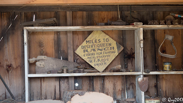
Here is a brief description of the ranch as it appears in Wikipedia: The Keys Ranch is the prime example of early settlement in the Joshua Tree National Park area. Bill Keys was the area’s leading character, and his ranch is a symbol of the resourcefulness of early settlers. The ranch is an extensive complex of small frame buildings built between 1910 and Keys’ death in 1969. Keys pursued both ranching and mining to make a living in the desert. The park policy is not to take more than 25 people per tour. The tour lasts two full hours. Because of our size, our group was divided into two smaller groups, group 1 and group 2. While group 1 was taking the tour, it was decided that Jim Buyens will take his group 2 and lead his group on two scheduled hikes for the day, namely Barker Dam trail a 1.3 mile loop trail and Hidden Valley Trail 1 mile loop trail. As seasoned hikers we can travel one mile every 25 minutes plus a few minutes to get in carpools drive a short distance in the opposite direction and hike a second trail. Hence two hours was ample time to accomplish these two hikes. Thank you, Jim, for leading your group. In the meantime, group 1 was taking a guided tour led by park ranger David Denslow, a 12 years veteran of his ranch presentation. He knew his facts and dates inside out, forward and backward. He was very thorough in explaining the history and hard life that Bill Keys and his wife Francis and their seven children endured. Yet they persevered. Despite his shooting to death of a rival over the disputed Wall Street Mill, and his subsequent conviction of the murder of Worth Bagley and banishment to San Quentin Prison, his wife Francis never wavered and waited for him at the ranch caring for their children all by herself. She must have been one tough woman! Bill was finally released from prison and the family continued to live at the ranch until their death. They were all buried in a nearby cemetery on the property. Due to vandalism, visitors are not allowed to view the grave sites. Upon his release from prison, Bill Keys erect a monument in honor of his victim Worth Bagley at the spot where Bagley was shot. Due to vandalism, the stone marker was removed by the custodians of the park and stored away until a final decision of what to do with it is determined. In its stead, a painted poster tells the story behind the event and marks the spot of the shooting. |
 There was a shoot-out here. [photo by John] |
|
The following are pictures of the ranch, Bill’s predecessor to the modern day Home Depot. Everything you needed to survive with in the desert, he had on his property or invented. Nothing ever went to waist. Every single item was put to good use as the pictures and captions demonstrate. |
 Everything you needed to survive. [photo by Wayne] |
 The ranch tool shed. [photo by Wayne] |
 Water tower. [photo by Wayne] |
 Windmill. [photo by Wayne] |
 Ranch house. [photo by Wayne] |
 Ranch house. [photo by Wayne] |
 Ranch house. [photo by Wayne] |
 Life-giving water came from here. [photo by Wayne] |
 Building landmark. [photo by Wayne] |
 Indoors. Can you see a ghost in this picture? [photo by Wayne] |
 Firestone. [photo by Wayne] |
 Tractor with a saw. [photo by Wayne] |
 Our first group to tour the ranch. [photo by Quy] |
 We are visiting, but they lived here. [photo by John] |
 Ranger David Denslow. [photo by John] |
 Trailblazers visit the ranch house. [photo by John] |
 Hey, look what I dug up. [photo by John] |
 Before indoor plumbing. [photo by John] |
 I’ll fix your wagon. [photo by John] |
 Now all the wagons are fixed. [photo by John] |
 ... and this is what we do with malcontents. [photo by John] |
 Junk? But what if we need these parts again? [photo by John] |
 Arrastra. [photo by John] |
 A genuine antique roadster. [photo by Sally] |
 The tires look good. And I can make you a deal ... [photo by Sally] |
 Hey, let’s go for a ride! [photo by Joe] |
 And miles to go before I sleep. [photo by Quy] |
|
By 12:00 PM Group I’s guided tour was over. We were led by David Denslow to the ranch’s gate where Group 2 was waiting to start their guided tour. Group I then proceeded to hike the two trails just completed by Group 2, namely Barker Dam and then Hidden Valley Trail. Barker Dam: a historical location, built around 1900, to hold water for cattle and mining use. The dam today forms a small rain-fed reservoir used by park wildlife. Birds abound. The park territory is known for its cattle ranching at least in the central and northern parts and mining mostly for gold. |
 Ripples break up reflections on the water. [photo by Wayne] |
 This is definitely worth exploring. [photo by John] |
 Water backs up behind the dam. [photo by John] |
 Barker Dam was not named for a dog. [photo by John] |
 Barker Dam, from the other side. [photo by John] |
 Livestock watering trough. [photo by John] |
 A light breeze makes ripples in the water. [photo by Sue] |
 Rocks stand in contrast to the liquid surface. [photo by Quy] |

|
Hidden Valley Trail: the trail starts in a picnic area. A small valley is surrounded by massive boulders ridges that once were rumored to have been used by cattle rustlers as a hideout for their cattle. |
 They had a blast! [photo by John] |
 The rock walls are finely textured. [photo by John] |
 Great stone columns of Hidden Valley. [photo by John] |
 A lot has happened here. [photo by John] |
 As I was saying ... [photo by John] |
|
Wall Street Mill Trail: a 2.2 mile in and out hike to the mining mill. At 2:00 p.m. both groups rejoined at the Echo Tee parking lot from and proceeded in one long caravan of cars to the Barker Dam and Wall Street Mill Trail, jointly used parking lot. Group 1 ate a quick lunch and then we all started our hike on the Wall Street Mill trail, a flat trail with lots of beautiful Joshua trees and rusting relics of modern day vehicles of the era left abandoned as souvenirs of bygone history. |
 Walk among giants of the yucca family. [photo by John] |
 A flat, Rudy, or is the motor missing? [photo by John] |
 Anne and Rudy on a date in a vintage car. [photo by Wayne] |
 Did you call for a service appointment? [photo by John] |
 Part of the stamp mill is still standing. [photo by John] |
 Stamp mill walls are of corrugated metal. [photo by John] |
 High tech of the 1930s. [photo by John] |
 The windmill stands tall. [photo by John] |
|
At the end of this hike we start our return trip to base camp but not before stopping first at Intersection Rock, a smoothly polished and heart stopping huge round boulder that challenges the bravest of the rock climbers. There is no cell phone reception in the park and not even a land line, not even among the visitors’ centers. The latter use special short wave radio to communicate with each other. But, and this is the kicker, there was an emergency telephone at the base of this Intersection Rock! I let you figure out why. |
 Climb me if you dare. |
|
Hall of Horrors: As we proceeded back towards our campground, we stopped at the Hall of Horrors, a 0.5 mile loop trail. It was very windy and cold but sunny, but also no high wire acrobatics today. We shall vicariously enjoy the high wire stunt through the camera shutters of other members of our group taken the day before. |
 Merrily we roll along. [photo by John] |
 Help! I’ve fallen and I can't get up! [photo by John] |
 How’s the view from up there? [photo by John] |
 Joshua trees point the way. [photo by John] |
 Yes, the trail is here. [photo by John] |
 A chip off the old block. [photo by John] |
|
It was dinner time and potluck time again. We had so much food left over from the previous night that we had no problem in over eating and there was still plenty left over food for a third night. After dinner, we retired to our pit fire routine: beer, wine, hard brew, jokes, laughter etc. Again it was a cold and windy night and we kept jockeying for seating spots away from downwind and smoke. Before you knew it, it was 10:00 PM again and hence curfew hours. But most of us had already retired to our tents. Only the hardy ones where still around the fire by 10:00 PM. |
|
Monday, March 6, 2017
Between 5 and 6 AM everybody was waking up and peeking out their tent. Yes, we are all still here. It is quiet, cold (30 degrees) and soon the sun will rise. Everybody is for himself / herself for breakfast but we all share in the use of stoves to heat water for coffee, fry an egg or two or sausages etc. It was sunny but very cold. The park’s location is 140 miles east of Los Angeles and 160 miles from San Diego. Both cities have large civilian airports. In the morning, you could see the contrails of the aircrafts criss crossing the skies above us. |
 140 miles east of Los Angeles and 160 miles from San Diego. [photo by Wayne] |
|
Our destination today is Keys View, a tall mountain clocked at an elevation of 5,185 feet and located in the central southern part of the park at the edge of the Little San Bernardino Mountains. This promontory point overlooks the Coachella Valley, I-10, Indio, Palm Desert, Rancho Mirage, Palm Springs, the snow-covered San Jacinto Peak (10,804 ft) and the San Georgonio Peak at 11,499 ft. Along I-10 right between these two mountain peaks is an opening in the mountain chain and serves as a conduit or wind tunnel for the exchange of strong air currents from the Coachella Valley east of the mountains chain and the Pacific Ocean driven winds blowing eastwardly from L.A. on the west side of the mountains chain. This exchange of winds directions throughout the day was a natural location to build wind turbine to generate clean energy all year round. You could see from our promontory at Keys Views these wind turbine farms. Westward looking, you can see the Santa Rosa Mountains and to the southwest you could see the flat blue patch of water which is the Salton Sea. It is 235 feet below sea level. This sea is shrinking and getting saltier because of the draught (less rain water) and agricultural runoffs for its saline water. Down below us you could see the famous San Andreas Fault. The sun was shining brightly, but it was a very cold and windy morning. We quickly took the quarter-mile paved trail hike around the peak, snapped as many pictures as we could and hurried back down to the parking lot where we had a group picture taken. |
 Wind power. |
 Wave for the camera. [photo by Wayne] |
 Distant mountains are snowcapped. [photo by John] |
 Don’t think we’ll be climbing there today. [photo by John] |
 Our view out over the valley. [photo by John] |
 It’s the Coachella Valley. [photo by John] |
 The ridge, dark and lone. [photo by John] |
 Scenic overlook. [photo by John] |
 Scenic overlook. [photo by Darrell] |
|
Lost Horse Mine: From Keys Views, we proceeded a few short miles and got onto a dusty, unpaved but smooth mile-long road to the trailhead of the Lost Horse Mine, a 4 miles in and out hike. The 10-stamp mill and mine represent the area’s gold mining prospecting and mining history. The sun was shining brightly but it was cold and windy (be always observant of how much clothing we were wearing). The trail is fairly smooth and is considered challenging because of the uphill. But you heard this before: what goes up must come down. Upon reaching the mine, we stopped for a half hour lunch break and photo shoots. The return hike was a breeze; downward hill. |
 Exhausted, Wayne fell asleep. We left him behind! [photo by Eileen] |
 Snow looks real cool. [photo by John] |
 Sign for the Lost Horse Mine. [photo by John] |
 The trail is that-a-way. [photo by Wayne] |
 This is an easy trail. [photo by John] |
 Let’s go on up the hill. [photo by John] |
 The mine equipment is fenced off. [photo by John] |
 They’ve dug up all the gold they’re going to. [photo by John] |
 The mine in its heyday. [photo by John] |
 On the trail again. [photo by Quy] |
 Climbing. [photo by Quy] |
 It’s cool up there. [photo by John] |
 A local summit. [photo by John] |
 Big climb. [photo by Quy] |
 Switchbacks on the way up. [photo by Quy] |
 Let’s celebrate! [photo by Quy] |
 Mine your own mine. [photo by Quy] |
 This Joshua tree is a good picture spot. [photo by Quy] |
 We’ve topped out. [photo by Quy] |
 Snack break. [photo by Wayne] |
 Time to start back down. [photo by Wayne] |
|
This concluded our hiking activities for this trip. We returned to campground and started preparing for our left over pot luck dinner for the third night. After dinner we regrouped again around the pit fire for our final and usual evening gathering of conversations, drinking beer and wine etc. |
|
Tuesday, March 7, 2017
The next morning it was time to break camp, and start the packing process of our carpools. It was time to say our good byes and wish each other a safe return trip to Phoenix. |
 Packing up to leave. [photo by Anne] |
 Got to get everything in the cooler. [photo by Anne] |
 Our last good-bye. [photo by Anne] |
 Have a safe trip home. [photo by Anne] |
|
But wait. There was one last group activity together before it is really all over. We arranged to visit General Patton WWII Memorial Museum. It was 5 miles on I-10 east of the park’s entrance and it would have been a shame not to visit it. The museum was on our way back to Phoenix anyway. So, a second guided tour was prearranged with the museum manager. At 11:00 AM most of us were present and the tour began. There was an inside museum where WWII pictures of General Patton were on exhibit along with many of his memorabilia and various WWII gear. A small theater repeatedly showed a 20 minutes video of General Patton’s history and the war effort. Then we proceeded outside the museum to view two dozen WWII tanks, trucks and other military hardware. |
 Never forget. [photo by Wayne] |
 General Patton stands tall. [photo by Wayne] |
 This tank saw plenty of action. [photo by Wayne] |
 Everyone should see this. [photo by John] |

|

|
| Patton remembered. [photos by John] | |
 The Allied High Command. [photo by John] |
 Trans-Atlantic communication. [photo by John] |
 The general’s typewriter. [photo by John] |
 Los Angeles Times. [photo by John] |

|

|
| Army Jeep and truck. [photos by John] | |

|

|
| Tanks. [photos by John] | |
 One more tank. [photo by John] |
 K.G. as tank commander. [photo by John] |

|

|
| A moment of reflection. [photos by Carol] | |
|
At the conclusion of the visit to the museum, most of us proceeded back to Phoenix. A few of us however, decided to drive a short distance in the opposite direction and visit the Salton Sea, some 45 miles west. |
 Salton Sea. [photo by Carol] |
 Yes Amber, the water is wet! [photo by Carol] |
|
Fun trip statistical information:
There were 35 hikers in total on this camping trip. By far, this is the largest group of hikers to date for an out of town trip for the Arizona Trailblazers Hiking Club. Thank you all for your participation. We did 10 scheduled hikes. However, not all of us hiked every single one of them. 12 hikers though did so and each hiked 18.55 miles cumulatively. 13 hiked 16.25 miles each. Collectively, we all hiked 539 miles, which is like hiking a relay race from central Phoenix to the park and back. As far as pictures taken contest (from those who responded): the most prolific hiker took as many as 800 pictures, followed by 700, then 571 pictures all the way down to 6 or 7 pictures! Somebody needs a camera! Pictures contributed for the trip report: 13 hikers out of 34 (I am excluded) submitted 226 pictures in total which includes several dozen that I lifted from Quy’s and Wayne’s Shutterfly sites. Hence you will find that Wayne, Quy and myself have a disproportionate number of pictures that appear in this trip report out of a total of 339 pictures posted. Miles driven to and from the park based on assumptions that you were the carpool driver who also drove in the park on our daily commutes, and back to Phoenix: 775 miles round trip. Otherwise, the round trip distance from central Phoenix to the park and back is 500 miles. Those who stayed in Indio, CA., you may add 70 more miles per day to your totals. Lastly but not least: To all the participants: thank you so much for your participation on this trip. You made it a reality, memorable and worthwhile all the effort and hard work put into it by everybody. Kudos to all of you. Your participation made this trip possible because without it, there could not have been such a trip. I hope our club does not wait another 20 years to revisit this beautiful park. Thank you all who shared your pictures with me for this trip report. I thoroughly enjoyed this adventure, in planning it, leading it with the most wonderful group of people and writing this trip report for our club’s archives. It is a long report and peppered with 339 pictures that depict our daily activities at the park. A three page report and three pictures would not have done justice to this great adventure. You will find the narrative and pictures follow the same order of activities we undertook on this trip. Take your time to read it, maybe not in one sitting but over a couple of days and relive your experience of this beautiful park and the camaraderie with such magnificent 35 trailblazers. Happy trails. |
 Top of Page
Arizona Trailblazers Hiking Club, Phoenix, Arizona
Comments? Send them to the AZHC .
updated May 15, 2017