Outdoor Links
Hike Arizona
Trip Planning Guide
Trip Report Index
Calendar of Events
Library
|
Wolf Creek Waterfalls Day Hike Prescott April 8, 2017 by Dave French |
|

|
||||
|
||||
|
When Mare Czinar published an article in the Arizona Republic on February 18, 2017, about the Wolf Creek Falls hike, there was instant interest by a large number of hikers. I jumped at the chance to lead this hike for the Trailblazers and scheduled it in April hoping that there would still be enough runoff to fuel the falls, and the weather would be warm enough to enjoy the hike. Fortunately everything worked out nicely. |
||||
 High over I-17. [photo by Quy] |
||||
|
I had lots of people wanting to sign up for the hike but I limited it to 20. Mare had indicated in her write up that the trail could be a little hard to follow and none of us had been there before. About three weeks before the hike, Billie Horn and I were able to pre-hike this trail and eliminated any concerns about following the trail. However, the falls are in a narrow ravine and it would be hard to fit a lot of people in there, so I tried to hold firm to the limit. But I messed up, and somehow did not count a couple of guests that I clearly remembered had emailed me, and they showed up right on time at Fry’s. So we had a couple of extras. No problem. |
||||
 Away we go on the rocky trail. [photo by Quy] |
||||
 Crossing Wolf Creek. [photo by Wendy] |
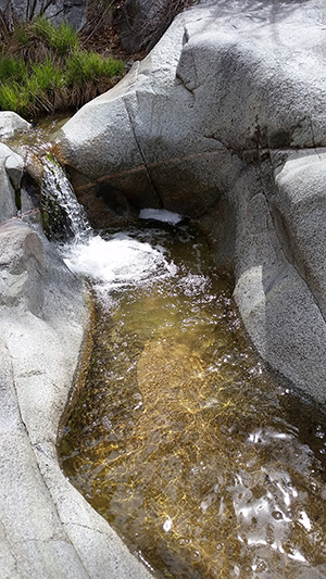 The Upper Falls. [photo by Wendy] There were some rocky spots but all in all it is pretty easy. We reached Wolf Creek after about 2.5 miles of hiking. We were able to cross the flowing creek and turned right on an unmarked path that leads down to the upper falls. I asked that about half the group go with me to the lower falls while the others explore the upper falls area. After our visit to the lower falls we came back up and the others made the scramble down to the lower falls. The falls were flowing, more like a cascade. This is not your Niagara Falls or even the Grand Falls of the Little Colorado, but flowing water in Arizona is always a treat. We ate our snacks and continued on trail 384 to the Hassayampa River. Most of you have seen the almost always dry Hassayampa River as you enter Wickenburg with a sign that says “No Fishing”. Well, we were near the head waters of this mighty river and it is a nice mountain babbling brook. There was a nice cascade, and several hikers scrambled over the rocks to get some nice photos of the stream. |
 Quy takes aim. |
 The Lower Falls viewed from above. |
 The Lower Falls. |
 Hikers view the lower falls. |
 Careful, Carl. |
 Wendy knows how to relax. [photo by Quy] |
 Hikers enjoy the cool falls area. [photo by Quy] |
 Trudging up the V-shaped trail. [photo by Quy] |
 Some giant lost his marbles. [photo by Quy] |
 Hassayampa above the cascade. [photo by Wendy] |
 Hassayampa cascade. [photo by Wendy] |
 Hassayampa cascade. [photo by Quy] |
 Hikers view the Hassayampa cascade. [photo by Nnn] |
 Crossing Wolf Creek again. [photo by Quy] |
 Don’t tread on me! [photo by Wendy] |
 Final leg of the hike. [photo by Quy] |
|
|
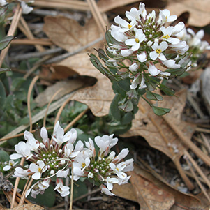
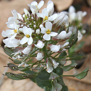
| Draba cuneifolia - Wedgeleaf Draba. [photos by Wendy] | |
|

|
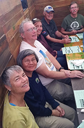
| At Lonesome Valley. [photos by Wendy] | |
|
We continued on trail 384 remembering to turn left off the ATV wide trail to follow the real trail northward to complete the 384 loop. Afterwards most of the hikers went to Lonesome Valley Brewpub in Prescott Valley for a late lunch. None of us had been there before, but the food and drinks were quite good. They squeezed all 18 of us into a little room that gave us nice cozy privacy. The hike was 7.5 miles long and the total elevation change was 1150 feet, hardly noticeable because the grades are gently rolling. The high and low elevations are 5556 to 6364 with the high point being near the trailhead and the low point at the falls. → video of the lower falls |
 This way. [photo by Wendy] |
 Top of Page
Arizona Trailblazers Hiking Club, Phoenix, Arizona
Comments? Send them to the AZHC .
updated April 10, 2017