Outdoor Links
Hike Arizona
Trip Planning Guide
Trip Report Index
Calendar of Events
Library
|
Alta-Bajada Loop South Mountain Park February 3, 2018 by David French |
|

|
| Randy, John, Tom, Ramona, Linda, Ken, Krista, Steve, Li, Kari, Sandy, Billie, Katarina, Dave |
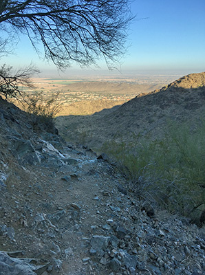 Looking westward. [photo by Randy] From the trailhead, we headed east on the Alta Trail and immediately began a climb that did not relent until we had gained 1000 feet in about 1.5 miles. We were on the north side of the Ma Ha Tuak Range with Maricopa Peak as the highest point. We did not get any direct sun until we reached the first summit and got good views to the west of the Sierra Estrella, Vi Quiva Casino, and parts of Lehi area. After a brief break in the welcome sunshine, we headed down and back into the shadow of the mountain. We continued eastward and eventually came to a second high point and back into the direct sunshine. From this viewpoint we could see across downtown Phoenix and Piestewa Peak and Camelback Mountain and more distant Four Peaks. The air was a bit hazy so the photos were not great. |
 Here we go up and up. [photo by John] |
 A short break. |
 The super moon is still there. [photo by Li] |
 Alta Trail. |
 Sierra Estrella and Via Quiva. [photo by Randy] |
 Finally we get a down grade. [photo by John] |
 Nearing the east summit. [photo by John] |
 View across Phoenix. [photo by Randy] |
 Ready to descend the Alta Trail. [photo by John] |
|
Again, after a brief break we headed down the Alta Trail with good views to the south and east across South Mountain Park. When we reached the bottom, we found a nice arroyo that provided some shade and rocks to sit on so we stopped for our snack break. We continued across San Juan Road to a small trailhead (this is where we started last year) and took the connecting trail east to the Bajada Trail and turned right to head west. The Bajada Trail is gently rolling and drops down into a few arroyos along the way. We reached the junction with the National Trail and crossed San Juan Road a second time. The last leg along the National Trail is fairly flat so the hikers really picked up the pace to reach the end and the cars. |
 Hikers all in a row. [photo by John] |
 Descending. [photo by Li] |
 Maricopa Peak from across San Juan Road. [photo by Randy] |
 Heading west on the Bajada Trail. |
 Truding back to trailhead on the National Trail. [photo by John] |
 Finally, the San Juan Lookout Trailhead. |
|
Seven of the hikers went to Los Dos Molinas Restaurant on South Central for eats and drinks. We got great service and everyone left happy. |
 Los Dos Molinas. |
|
There were 14 hikers. We had two drop out at the last minute due to illness and two no shows.
Here are the stats: |
 Top of Page
Arizona Trailblazers Hiking Club, Phoenix, Arizona
Comments? Send them to the AZHC .
updated February 6, 2018