Outdoor Links
Hike Arizona
Trip Planning Guide
Trip Report Index
Calendar of Events
Library
|
Cat Peaks Day Hike Goldfield Mountains February 17, 2018 by Ted Tenny |
|
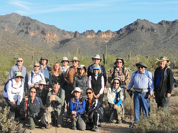 Hikers about to start from Meridian Trailhead. [photo by Dave] |
||||||||
|
||||||||
|
When I scouted this hike there were lots of spring flowers. But we’ve had such a dry winter in 2018 that most flowers weren’t there this time. The rocks are always lovely. Nineteen nifty Trailblazers started from Meridian Trailhead on a gorgeous winter morning. We crossed Sand Canyon on the trail, then turned left on the Pass Mountain Trail and walked west to the Cat Peaks junction. |
||||||||
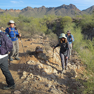
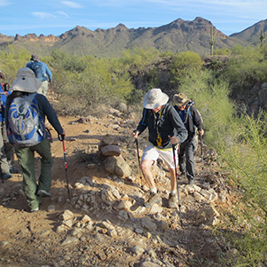
| Trailblazers climbing out of Sand Canyon: |

|
|
|

|
 Westward on the Pass Mountain Trail. |
|
“The only way you can do this figure-8 is to hike the same trail twice in the same direction,” I explained when we got to the Cat Pass Trail. So up we went. Most of the hikers took the side trail to a lookout. Then we re-convened at the bottom, went southeast on the Blevins Trail, east on the Meridian Trail, then north on the Cat Peaks Trail. |
 Look how far you can see from here! |
 Some of us climbed Peak 3127 on the Awards hike. |
|
When we got to the Cat Pass Trail a second time, we saw lichens on the boulders nearby. “Who knows the legend of the lichens,” I asked. Not everyone did, so I told them: Lichen is a symbiotic community of algae and fungus. |
 Temptation Peak and Bulldog Ridge from the Cat Peaks Trail. |
|
Amazingly, everyone was still together when we got back to the Cat Peaks junction. The folks who were doing the loop around Pass Mountain took off westward with Chuck Parsons as their leader. The others turned right and walked with me back to Meridian Trailhead.
|
 “Short” hikers Ted, Barb, Karen, Andy, Eileen, Joe. |
 Haze makes the Superstition Mountains a ghostly apparition. |
 “I don’t care about the drought. I’ll bloom anyway.” |
 Chuparosa in Sand Canyon must be getting water. |
|
There were lots of people out hiking and riding bikes in Usery Mountain Park on such a fine day. I’ve heard there is a proposal to enlarge the park to include all of Pass Mountain, and Lone Mountain. Thanks to Chuck for leading the loop around Pass Mountain! |
|
→ More pictures, by
Carl.
|
|
Supplemental Report by Chuck Parsons |
|
||||||||||||||
|
After completing Ted’s Cat Peaks Trail Figure-8 hike, the full group of 19 hikers returns to the Cat Peaks/Pass Mountain Trail junction at about 10:30. The 13 long-haul hikers bid Ted’s group goodbye and a safe passage back to Meridian Trailhead and then hang a hard left onto the main Pass Mountain Trail and begin our journey to complete the full 7.5-mile Pass Mountain loop. At this point we’re either the Fearless 13 or the Crazy 13, or perhaps even both. Hopefully, though, we won’t become the Unlucky 13. Only time will tell for sure.
Ted recommends hiking the Pass Mountain loop clockwise, so that’s our game plan for the day. From the junction, where we part with Ted’s group, the Motley 13 (our handle for the time being) head west for about a mile and then start hiking north for several miles along the western flanks of Pass Mountain to the far north end of the loop. At roughly the mid-way point at the north end we’ll stop for a lunch and rest break, before starting the return leg of the hike, heading south along the eastern side of Pass Mountain. As Ted mentions earlier, there’s a proposal underway to enlarge Usery Mountain Park to include all of Pass Mountain and Lone Mountain completely within park boundaries. Currently, only a quarter of the Pass Mountain Trail lies within Usery Mountain Park, while almost 75% of the trail runs through Tonto National Forest, which butts right up against the current park boundary. Although certainly no expert on this topic, I would hazard to guess that if this proposal does go through both Pass Mountain and Lone Mountain would receive better protection under the jurisdiction of Usery Mountain Park than they currently do under Tonto National Forest. But I could also be dead wrong about this. I’ve been wrong at least once before in my life.
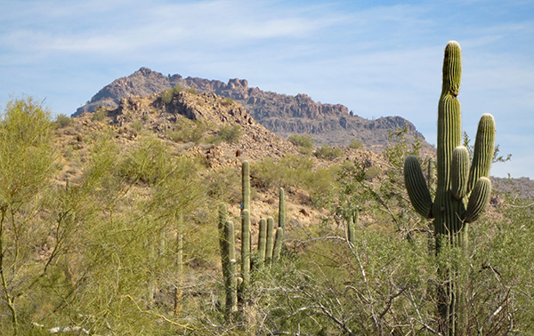
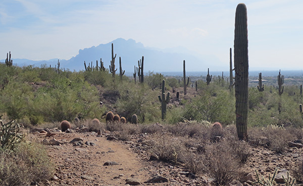
If you could use just one word to describe the Pass Mountain Trail, it would be rocky. A good two-word description would be really rocky. Then again, that description could also fit just about any hiking trail in the state of Arizona. At one point on the hike Joe mentions his son, who had considerable hiking experience while living in Arizona. After living and hiking in a couple of other states for several years and then returning to Arizona for a short vacation, which included some hiking, he suddenly remembered just how rocky Arizona trails are. But in addition to being rocky, the Pass Mountain Trail also offers some of the best overall desert scenery and breathtaking views to be found anywhere in southern Arizona, especially along the northern and eastern stretches of the loop trail. Outside of Saguaro National Park near Tucson, the west side of this loop trail offers sweeping vistas of some the largest and densest stands of giant Saguaros in Arizona’s vast Sonoran Desert. We also encounter sprawling staghorn cholla forests as we move further up the trail. A forest of chollas? Absolutely. As we steadily work our way north on the trail, along the western slope of Pass Mountain, we begin to encounter numerous switchbacks which carry us higher and higher on the trail. But we also encounter the increasingly louder reports of gunfire from the busy rifle range far below us and to the west. Thankfully, that slowly fades away as we continue moving northward. It’s just past noon when we reach the far north end of the loop and break for lunch. And it’s here where the finest views on the trail begin to come into play. From here and then later as we slowly make our way south down the east side of Pass Mountain, we take in sweeping views of the mighty Goldfields (Ted’s home away from home), the imposing and mysterious Superstitions, the sprawling Mazatzal Range, terminating at its southern end in the landmark Four Peaks, Stewart Mountain, Mt. Ord, and even farther out to the east the Sierra Anchas, overlooking the Tonto Basin. This stretch of the Pass Mountain Trail is truly an inspiring Arizona Highways moment.
From the east end of the loop and the pass, it’s almost all downhill. On the flip side, however, the trail becomes even more rocky and rugged as we continue descending along the eastern flanks of Pass Mountain. Short stretches of this trail are covered in loose gravel and we have to pick our way through very carefully to avoid a disastrous wipe-out and a potential search & rescue, in addition to a possibly embarrassing and unwelcome segment on the six-o’clock evening news. At one point on the descent we all take a much-deserved break on a long stretch of slickrock, nestled up against the base of soaring green and yellow lichen-covered cliffs this spectacular mountain is famous for. Here I confer with Michael, and we both agree that we have roughly two more miles of trail to complete before we can officially call it a day. That last mile or two of trail always seems to take the longest, and this is certainly going to be no exception. So we bravely soldier on and continue to carefully navigate the final home stretch of trail. At 2:00 PM the entire contingent of 13 Pass Mountain long-haulers is back safe and sound at the Meridian Trailhead, where our vehicles patiently await us.
Most of the group heads for the closest Red, White, and Brew for eats and libations, while a few hikers opt to head home. It’s been another great day for hiking the always amazing trails of Arizona. Is this state a hiker’s paradise, or what? Chuck |
|||||||||||||||


 Top of Page
Arizona Trailblazers Hiking Club, Phoenix, Arizona
Comments? Send them to the AZHC .
updated February 20, 2018