Outdoor Links
Hike Arizona
Trip Planning Guide
Trip Report Index
Calendar of Events
Library
|
Clover Creek Day Hike Mogollon Rim June 16, 2018 by Chuck Parsons |
|
 A small group of Trailblazers prepares for the Clover Creek Trail hike. [photo by Monika] |
 Monika, Jim, Jeanne, Heather, Chuck, and Wendy gather near the trailhead. [photo by Wendy] |
|
Today’s hike was originally scheduled to be the Col. Devin Trail, one of only a handful of trails ascending all the way to the top of the Mogollon Rim. But after the Col. Devin Trail was closed because of extreme fire danger, I had to change the hike to the Kelsey-Dorsey Trail. Then when we couldn’t line up any high-clearance vehicles to ferry all of us to the trailhead, I had to scrub the Kelsey-Dorsey hike and replace it with the Clover Creek Trail hike, last hiked by the club in June, 2010, and one of the few remaining Mogollon Rim trails still open. At one point I had 20 people signed up for this hike, but because of the change in hiking venue, not just once, but twice, as well as the questionable weather forecast for today, after all the fall-out we wind up with only six hikers this morning. This was the highest cancellation rate (70%) that I’ve ever experienced since leading hikes for the Motorola Hiking Club back in 1998 and may actually be an all-time record, although not necessarily an enviable one. But, at the same time, a smaller number of hikers is nice for a change, with a much more personal feel. On the drive up Highway 87, we start experiencing heavy rain showers well before we reach Payson. Windshield wipers are going full speed, as they struggle to keep up with the downpour, and we start to wonder if we should have slept in late this morning to stay dry and just skipped the hike today. |
 Cattle gate across the Clover Creek Trail. [photo by Wendy] |
 Arizona Trailblazers start hiking under a light mist. [photo by Wendy] |
 West Clear Creek Wilderness Sign. [photo by Wendy] |
 Remnants of the old bridge from a bygone era. [photo by Jeanne] |
|
But this is a very determined group of hikers, so we press onward, throwing all caution to the wind. At least we’re not seeing any bright flashes of lightning through the dark cloud cover—not yet, anyway. So we keep our fingers crossed and hope for the best. We reach the Clover Creek Trailhead and begin hiking at 9:40 AM, under solid overcast and a light mist, barely enough to warrant donning raingear. The temperature is a damp and refreshing 53 degrees this morning, nearly 60 degrees below the previous week’s high in the Phoenix area, which has also gone without measurable rainfall for over 100 days. What an unbelievable contrast in weather conditions! But we need to savor these cooler temperatures while we can, knowing full-well the stifling June heat that awaits us when we arrive back in Phoenix. It’s quite evident this area has received heavy rainfall during the night or perhaps earlier this morning, with droplets of rain clinging to virtually every surface and every blade of grass. The air is pure and intoxicating and cleansed of all dust and pollens. Both the Forest Service road to the trailhead, and the trail itself, were soaked enough by the rainfall to be compacted and free of the dust and dirt that has plagued us on all of our hikes over the past few months. |
 From their size, we suspect these are elk bones. [photo by Wendy] |
 Monika seems to be having a great time. [photo by Wendy] |
 “Raindrops Keep Falling on my Leaves.” [photo by Jim] |
 This Cliff rose and its leaves are highlighted by droplets of rain. [photo by Wendy] |
 This lone Golden Columbine adds a bit of color to the trail. [photo by Wendy] |
 Close-up picture of leaves and rain drops. [photo by Wendy] |
 The scenery keeps getting better and better. [photo by Jeanne] |
|
Has the long-awaited Arizona monsoon season finally arrived? We can only hope so, since Arizona’s distressed forests are dangerously parched and in desperate need of moisture to keep those pesky and highly destructive bark beetles at bay. But, most important of all, we need rain and lots of it to minimize chances of forest fires and reopen huge swaths of National Forests across the state that have been closed to all entry in recent weeks due to the extreme fire danger conditions. 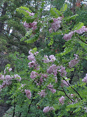 New Mexico Locust. [photo by Monika] The trail is an easy walk along Clover Creek, as it meanders back and forth across the creek and through a beautiful lush green meadow and gradually winds its way down toward West Clear Creek. Large stands of Ponderosa pine and Douglas fir, along with willows, alders, New Mexico locusts in full bloom, and numerous other tree species line both sides of the creek. Despite the earlier rainfall, the creek remains dry. We continue to hike in a light mist, with dull-gray overcast skies, and keep our fingers crossed that the heavens don’t suddenly open up on us. Fortunately, we all have raingear but still don’t wish to hike in a total downpour, or what Southerners sometimes refer to as “a good old-fashioned frog strangler.” Also, as we keep working our way up the canyon and the canyon walls start to narrow down a bit, the possibility of a sudden flash flood starts to become more of a concern for us. But, as Jim points out, there doesn’t seem to be too much evidence of previous flash flooding in this canyon, as we’ve seen on other canyon hikes like the West Fork of Oak Creek Canyon. |
 We enter the official West Clear Creek Wilderness area. [photo by Wendy] |
 This must be a very rare species of tree. [photo by Wendy] |
 Trailblazers continue to work their way up the trail. [photo by Wendy] |
 Time out for a quick discussion. [photo by Wendy] |
|
Nevertheless, we still need to be wary and stay alert of our surroundings. After roughly a mile and a half of hiking, the canyon starts to narrow down a little, with high cliffs of lichen and moss-covered Kaibab Limestone on both sides of the creek bed. And so far the serious rains are still holding off, with only an intermittent mist still coming down. The mist stops for a while and we remove our rain gear. Then it starts back up again, and we don our rain gear once again. |
 Mosses are thriving in this location. [photo by Wendy] |
|
This cycle continues to repeat itself throughout the hike. There’s only minimal elevation change along this trail, as we continue making our way up the canyon and cross back and forth across the creek from time to time. |
 Both lichen and mosses have taken up residence here. [photo by Wendy] |
 A stand of daisies gently nods in the breeze. [photo by Wendy] |
 The canyon walls become higher and higher. [photo by Wendy] |
 Chuck poses against the cliff for scale. [photo by Jeanne] |
|
A sudden rush of water down the creek bed would send up scampering for high ground immediately, but thankfully nothing so far. |
 New Mexico Locust growing against the Kaibab Limestone. [photo by Wendy] |
|
After about 90 minutes of hiking, we decide to stop for a snack and rest break in a heavily forested area of the canyon, where a large Ponderosa log provides the perfect seating area. It’s close to 11:00 AM, by the time we all sit down for a rest break. So far the scenery grows increasingly spectacular along the Clover Creek Trail, and there’s anticipation and excitement around every bend in the trail. After the break we continue hiking and exploring deeper into the canyon until the trail eventually becomes choked with overgrowth and disappears altogether. This will mark our turnaround point, and we decide to head back to the trailhead from here. It’s been completely overcast all day, with a light mist for most of the hike and not a single shaft of sunlight penetrating through the heavy cloud cover. Pretty amazing weather for mid-June, even in Rim Country, Arizona. |
 Close-up picture of the locust blooms. [photo by Jeanne] |
 The further we go, the more Kaibab Limestone we see in the canyon. [photo by Wendy] |
 The perfect location for a quick snack and rest break. [photo by Jeanne] |
|
We’re probably less than a half-mile from the trailhead when the mist gets a little more serious and changes into a light to moderate rain shower. We’re all suited up in full rain gear mode from here on. And we’re Hiking & Singing in the Rain. All of us arrive safely back at the trailhead without incident by about 12:45 in the afternoon. The skies are still overcast, and the temperature has climbed all the way from 53 degrees to 59 degrees. Priceless! We stow our wet gear away and head back down the road to Pine for a late lunch. The timing couldn’t have been more perfect, since the skies open up shortly after we depart from the trailhead, and once again windshield wipers are switched to high speed mode. The rain stops shortly before we pull into That Brewery & Pub on the south end of Pine. |
 Hmmm. There seems to be some serious concerns going on here. [photo by Wendy] |
 Six hungry Trailblazers break bread at That Brewery & Pub in Pine. [photo by Wendy] |
|
But it continues to rain hard while we’re eating lunch, and the rains stay with us on and off until we’re well south of Payson on the drive back home. What a great day this has been for hiking Arizona’s Mogollon Rim! And for those who missed the hike, well there’s always next time. The Clover Creek Trail and the Mogollon Rim will still be there, waiting for you to put boots to the ground and start hiking. We are, after all, the Arizona Trailblazers Hiking Club. |
 The Trailblazers’ Quartet: Monika, Heather, Jeanne, Jim [photo by Wendy] |
| → Monika, Heather, Jeanne, & Jim: “Hiking & Singing in the Rain ”, by Wendy. |
|
Supplemental Report by Jim Buyens |
|||||||||||||||||||||||||||||||||||||||||||||||||
|
Chuck, thanks for organizing and leading this hike despite the constantly-shifting forest closures and high probability of rain. And thanks to everyone else for persisting through the same obstacles. It was a treat hiking with you. Jim |
|||||||||||||||||||||||||||||||||||||||||||||||||
|

|
||||||||||||||||||||||||||||||||||||||||||||||||
 Top of Page
Arizona Trailblazers Hiking Club, Phoenix, Arizona
Comments? Send them to the AZHC .
updated June 21, 2018