Outdoor Links
Hike Arizona
Trip Planning Guide
Trip Report Index
Calendar of Events
Library
|
Rogers Lake Day Hike Flagstaff July 14, 2018 by Jim Buyens |
|
|
|
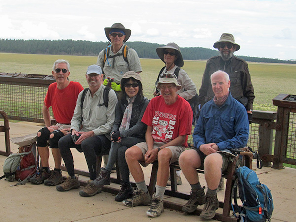
Tom, Ralph, Mark, Li, Heather, Bill, Terry, and Jim on the wildlife viewing deck near
the trailhead. The large grassy field in the background is Rogers Lake. [photo by Bill] |
|
With the Forest Service having closed so many hiking areas because of fire precautions, finding great places to hike had become a challenge. Then I noticed an article in the Arizona Republic, titled Flagstaff hike: Rogers Trail hike is a lovely walk in the woods, by Mare Czinar, describing a great new 5.4-mile trail southwest of Flagstaff. Voila! The Rogers Trail runs from the Loop Trail near Fort Tuthill County Park to the Gold Digger Trail in Rogers Lake Natural Area, which is another county park. The Gold Digger Trail appeared to be a 4-mile loop with one mile running along a lakeshore, and that seemed too good to miss, so I planned the hike to start the Gold Digger Trail, turn onto the Rogers Trail for three miles, and then return to the Gold Digger Trail and finish the loop. Because neither I nor the club had ever hiked either trail, the day was definitely exploratory. The weather forecast called for 80% chance of thundershowers, but for eight of us, at least, that was no deterrent. Reaching the trailhead required driving about five miles of gravel road but it was in good shape and passable by all cars. Ralph reconnoitered the route during the preceding week and provided an excellent set of directions. The trailhead serves not only a trail but also a wildlife viewing deck, with telescopes and overlooking the lake. Unfortunately, however, the lake was dry and the only wildlife we saw was a herd of cows grazing on the grass that’d grown on the exposed lake bed. |
 Jim, Mark, and Heather get organized before starting the hike. [photo by Li] |
|
The start of the trail is marked as the Two Spot Trail, a shorter loop, but the map showed that trail connecting to the Gold Digger after a short distance and so it did. The trails all day were wooded, rolling, not very rocky, and decidedly pleasant. About halfway out a fine rain came in, leading about half the group to don raingear. Then a half hour of that, the rain became an actual shower and the rest of us geared up. The shower cleared up after another half hour, though, and there was no significant rainfall the rest of the hike. |
 Li and Heather model the latest fashions in raingear. [photo by Tom] |
|
There’s a lookout point about a mile into the Gold Digger Trail, but it wasn’t very high and no one seemed interested so we bypassed it. Nevertheless, this might be something to add in future hikes. |
 We didn’t spot any wildlife during the hike but we did encounter these remains. [photo by Li] |
|
The junction with the Rogers trail had only a blank marking post but it was in the right place—about 2.2 miles into the hike—and it seemed to be heading in the right direction so we tried it. Later trail markers confirmed we were on track. |
 Jim and Bill cross-check navigation. If the map says “You are here,” that’s where we must be. [Tom] |
 Is it a picnic ramada or a rainfall-collector? No, wait, it’s Li! [photo by Tom] |
|
We passed two structures on our way out. The first looked like a covered picnic ramada but with no parking lot and no road nearby that didn’t seem right. Then we noticed rain gutters leading to a large tank and decided the idea was to catch the rain and store it, most likely for animals. If any animals were around, though, we certainly didn’t see them. |
 When the trail becomes a river everyone heads off-trail. [photo by Ralph] |
|
The second was a small group of buildings, not all of which seemed to be in use. There was a tall antenna tower but only one antenna, seemingly ruling out the idea of a relay station. There were large cabinets with, “Danger High Voltage” signs on them, but no humming sounds and no motors running nearby. Then we spotted a large steel tube that was about four feet in diameter, sticking out about three feet above the ground, and locked. It seemed that the tube probably continued underground, perhaps to service some pumping equipment, and so our final verdict was that the whole installation might be a pumping station. Or a UFO meeting place. Or a missile silo. But no, probably a pumping station. |
 Ralph keeps dry under his brolly. [photo by Tom] |
 Is it a relay station? Or a pump house? Or a secret government installation? [photo by Li] |
 Is it a table or the top of a vertical shaft? [photo by Tom] |
 If you know what WM-10 55-548-560 A-21-06-BCB means, please contact the hike leader for a low-voltage reward useful in emergencies. [photo by Tom] |
|
The Rogers trail runs south of Woody Mountain, which rises about 400 feet above the trail elevation. There’s no trail to the summit but there is an access road. The map shows no connecting trail from the Rogers Trail to the access road, but some on-line accounts refer to one. So that might be a point of interest to investigate next time. When we were five miles out I asked the group if they wanted to turn around, but there were no takers. Everyone was enjoying the trail so much they wanted to continue. We then discussed hiking to the Arboretum at Flagstaff, which has a one-mile nature trail that seemed interesting, but that would have increased the day’s distance to fifteen or sixteen miles. That seemed a bit much. So instead we turned around when we got to the Loop Trail, which marks the eastern end of the Rogers Trail. Returning on the Rogers Trail was pretty much the same as going out, except that the rain had stopped and everything was backwards. When finishing the Gold Digger Trail loop, however, it turned out that trail wasn’t a loop at all: it was more like a 270° arc straddling the smaller Two Spot Trail loop. So we picked up about a mile and a half of the Two Spot trail that we didn’t expect. But it was on the last part of the hike and it was flat and it wasn’t raining so nobody complained—much. |
 Here we are starting the lakeshore portion of the hike. [photo by Bill] |
 The San Francisco Peaks overlooking Rogers Lake. If you look closely you can see some cows grazing on the lake bed. [photo by Bill] |
 It might be time for some new boots, Bill, or at least new duct tape. [photo by Li] |
|
After the hike we drove into Flagstaff and had lunch at the Taverna Greek Grill, which seems to be becoming a cub favorites. As usual the food, the service, and the facilities were all great. |
 Bill, Heather, Terry, Jim, Mark, Tom, and Li enjoy a well-earned repast after the hike. [photo by the waitress using Tom’s camera] |
|
Overall, everyone really enjoyed the hike and urged me to schedule it again next year. There are, however, three point of interest that we missed: The Gold Digger lookout point, climbing Woody Mountain, and the Arboretum. Including all those in an out-and-back hike would run the distance up to 15-16 miles, though, so maybe we should stop at the arboretum on our way to the trailhead, or maybe the hike should be a one-way. I can hardly wait! |
|
|
|||||||||||||||||||||||||||||||||||||||||||||||||
 Top of Page
Arizona Trailblazers Hiking Club, Phoenix, Arizona
Comments? Send them to the AZHC .
updated July 18, 2018