Outdoor Links
Hike Arizona
Trip Planning Guide
Trip Report Index
Calendar of Events
Library
|
Saddle Mountain Day Hike Mazatzal Mountains December 1, 2018 by Michael Humphrey |
|
 Seventeen Trailblazers ready to roll. [photo by Quy] |
||||
|
||||
|
Seventeen Trailblazers have decided to hike the Saddle Mountain part of the Arizona Trail, Passage 22, today. We meet for the cars pools in the dark so we can get an early start, but Mother Nature has thrown us a curve ball, with today being one of the lower temperature days of the year with a possibility of rain. |
||||
 Clouds of the pre-dawn blue hour. |
||||
|
We have to wait a little while where we exit US-87 for the trailhead, as one of the cars decided to see more of the darkened US-87 than planned, so we get some extra photos. Cross F Trailhead is hard to find because the Forest Service decided to move the sign from beside the road to the top of the hill. But I have been here before. The trailhead is bountiful for pictures this time of year with the trees changing colors. |
||||
 Debbie, Li, Carolyn and Moé enjoy the autumn colors. |
||||
 Quy, amid the autumn leaves. |
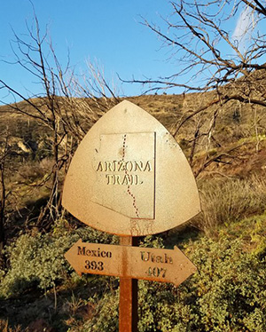 We’ve made it to the Arizona Trail. Here we can see that it is 393 miles to Mexico and 407 miles to Utah. The trail continues its upward journey to Saddle Mountain Pass, passing some interesting rock formations. After a while we get to parts that burned in the Sunflower fire of 2012. The area is covered in grass and low brush, but it will need a few more years to get the trees back. We get to the junction with the Saddle Mountain Trail, which is where the hikers for the short trail will turn back. The short trail is 8 miles and 1,000 feet of elevation gain. This junction also goes to the Mormon Trailhead, which is reachable over a bumpy dirt road. The long trail hikers will go for another 3 miles to up and over the Saddle Mountain Pass. The long hikers will also get to the halfway point of the Arizona trail, with 400 miles both to Mexico and Utah (or least in a past time). From Saddle Mountain Pass you get views of Mt. Ord, Mt. Peeley and Mazatzal Peak. |
 Rock formations along the way. |
 The colors in the rocks are amazing. |
 Aftermath of the Sunflower fire. |
 Mt. Ord is cloud-topped. |
|
This is the highest elevation we will be doing today, at 5,500 feet. Only Mt. Ord had snow that we could see. We continue down to the junction with the Sheep Trail, which winds its way down and into McFarland Canyon. This is our lunch spot and turnaround spot. Due to the threat of rain in the afternoon we will not go into McFarland on this trip. We find a sunny spot for lunch and have a quick lunch. The clouds are getting darker and we have 7 miles to walk to get back to our cars. The trail back to the cars is faster because it is mostly downhill. Everyone gets back to the cars before 4 PM, and Mother Nature has held off the rain until we are back in the cars and headed back to Phoenix. |
 Colorful rocks and trees. |
 We have a stream to cross. |
 All’s well that ends well. |
|
Due to re-alignment of the Arizona Trail, the halfway point of the Arizona Trail on this day is in Passage 23, but it may change back to Passage 22 with some of the planned changes. Who knows if and when they will change the mileage signs? We get back to Phoenix as the sun is setting on a great day of hiking. This is a very nice trail less than an hour from Phoenix, but we were the only persons on the trail this day. |
 Top of Page
Arizona Trailblazers Hiking Club, Phoenix, Arizona
Comments? Send them to the AZHC .
updated December 22, 2018