Outdoor Links
Hike Arizona
Trip Planning Guide
Trip Report Index
Calendar of Events
Library
|
Bassett Peak and Willcox Wine Weekend Galiuro Wilderness, near Willcox November 8-10, 2019 by Tamar Gottfried |
|
|
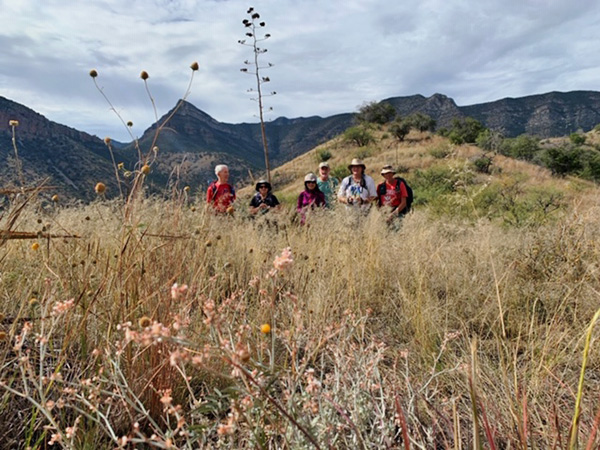
| Tom, Tamar, Li, Bud, Michael, Bill |
 On the trail. [photo by Bill] |
Six trailblazers started a wonderful Southern Arizona weekend by meeting at Kartchner Caverns State Park on a Friday morning. We went straight to the Guindani Trailhead and headed out on the trail. The weather was mellow, the sun was strong and we warmed up on the gentle hills, stopping for photos in a pretty little wash with a few ponds and again, up on a hill with views all the way to Mexico. We passed some camo-wearing hunters scoping on a hillside and made our way back to the parking lot. The trail was quiet, barely occupied, and a good introduction for a hiking weekend. After a quick Subway lunch stop in Benson, we got back on the road and headed to our destination in Willcox. Our first stop was a private wine tasting at the Pillsbury Winery, which is outside of town. |
 Tom, Li, Tamar, Michael, Bill, Bud. [photo by Bill] |
 Hmmm, that looks interesting. [photo by Bill] |
|
We met two more members of our group there, along with our hostess, Teri, and her friendly dog, Gus. She gave us a great history of the wine industry and wine making in Southern Arizona and we tasted a number of reds and whites. Several of us were impressed enough to purchase a few bottles. Afterwards, a few folks visited a second nearby vineyard, while the rest of us headed to hotels for a quick clean up before dinner. That evening, eight of us dined at the Double S Steakhouse in Willcox. The salad bar was a hit and the salmon was good too. |
 Taste it! [photo by Bill] |
 Our hostess, Teri. [photo by Bill] |
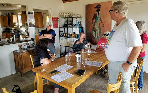 Wine tasting. [photo by Tom] |
|
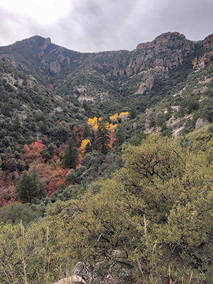
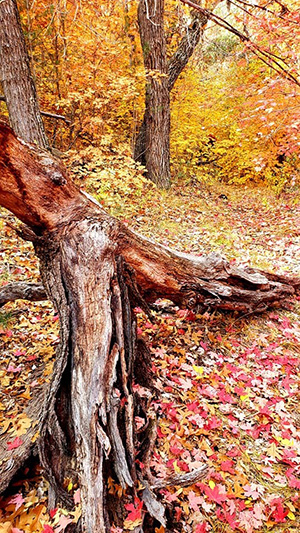
Saturday morning, nine of us convened before 6am at the local McDonald’s for a quick hot breakfast. We then headed toward the Galiuro Mountains in two trucks and a Jeep. The 14 miles of dirt road weren’t too bad, but then we set out on FR 660, which was a bumpy, rocky, car tipping ride. Along the way we met Ken and Scott, who hitched a ride in one of the big, sturdy trucks. After about 2.5 miles, we reached a wash that seemed like the end of the line. Although we found no official trail sign, the drivers agreed to park there and we started off on our adventure. A few steps in and we were greeted by an abundance of color, the typical oranges and yellows, but also joined by pink, red and magenta leaves, in the trees and carpeting the ground, more and more as we walked on the trail. Our pace really slowed as we couldn’t resist taking multiple photos of the autumn wonderland. Our quest to see the peak of Fall color in Southern Arizona was fulfilled. |
 Let’s get into the autumn color. [photo by Tamar] |

|

|
| The best and the brightest! [photos by Tamar] | |
 Bill is in the red leaves. [photo by Tamar] |
 Pure gold. [photo by Tamar] |
 The trail has twists and turns. [photo by Tamar] |
 Look before you leap. [photo by Tamar] |
 What a view! [photo by Tamar] |
 Let’s rest a while. [photo by Tamar] |
 The summit? Maybe next time. [photo by Tamar] |
 Best of the autumn color. [photo by Tamar] |
|
As we walked farther in on the trail, we had to do some route finding. Typically a thin black water piper accompanied the trail, but it seemed to split as it went down banks and across washes. Then, another obstacle in our path—increasingly narrow passages through the trees with unkempt branches of the maples and oaks, scratching arms and blocking our paths. In places we were truly blazing through bushes and some were manzanita, not friendly. |
 Trailblazers amid autumn color. [photo by Li] |

|
|
| Colorful leaves. [photos by Lin] | |

|

|
| Red leaves, everywhere. [photos by Lin] |
|
Eventually, after 3.5 miles and 2 hours (was 2.5 miles per the official trail description), we reached the famed Aspen grove, with tall Aspens (supposedly 30 of them) with yellow heads. This was a little oasis in a wash and we stopped to marvel how it had taken so long to get there. Two people turned back at or before that spot. The other nine hikers hiked out of the grove, leaving the fall color show and entering the high desert. The trail began to climb and was hard to follow in places, due to dense groupings of manzanita. We went up rocky switchbacks to a flatter area with an arch and were able to mark our progress by looking down on the orange aspen grove in a sea of green below. |
 I’m in my element. [photo by Tom] |
 We see the best of the fall color! [photo by Carl] |
|
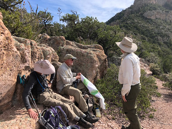
At approximately the 4.5 mile mark (5 on some people’s GPS, but less than 4 on the official signage), all but four hikers had decided to turn around. The first part of the hike did take a little longer than expected due to the overgrowth of plant life and other factors, and the drivers did not want to be on the rough part of the road at dusk or dark. A decision was made that everyone should be turned back by noon. Four of us reached the ridgeline of the divide trail—marked as 4 miles from the trailhead and 1.4 miles from Bassett Peak summit. We continued across the ridge and began a series of switchbacks on a narrow, scree-filled trail. We were able to spot the wreckage of the the WW2 plane that crashed in 1943 across the ridge. At noon, we reached the beginning of the last set of switchbacks. The two front hikers found the trail to be eroded and slippery and, per our agreement, we turned around about 200 feet of elevation and 4 miles from the summit. Maybe next time. The trail downhill went much faster and was easier to follow and we were all back at the cars by 3 PM. After some celebratory M and Ms, we were back on the road and back to pavement before 4 PM. |
 Bud is having a good time. [photo by Bill] |
 Nancy is fearless. [photo by Bill] |
 Let’s take some pictures. [photo by Bill] |
 How are you going to get around that log, Tamar and Michael? [photo by Bill] |
 Is there any liquid inside? [photo by Bill] |
 Merrily, merrily, down the trail we go. [photo by Bill] |
 Bill is on top of the world (well, maybe not quite). [photo by Bill] |
 Nancy amid the autumn leaves. [photo by Bill] |
 We’ve found the brightest red leaves. [photo by Bill] |
 Trailblazers enjoy dinner. [photo by Tom] |
 Bud tries a big glass. [photo by Tom] |
|
Ten Hungry hikers convened at La Unica Restaurant and Tortilleria in Willcox for a wonderful post hike dinner. The staff was ready for us and accommodating and the fresh food and homemade tortillas hit the spot. Most impressive was Bud’s Cadillac Margarita, which was almost as large as he was. We also enjoyed a selection of local wine. Sunday morning, eight of us met at the Sunset Inn and headed out toward Fort Bowie. After a 45 minute drive, some on a well maintained dirt road, we arrived at the parking for the site. You have to hike in to see this historical site. We learned a lot about the history of the area and the circumstances surrounding the founding of the Fort and its history with the soldiers and the Apaches, including Cochise and Geronimo, and the importance of the spring as we walked through time. We visited a cemetery, the spring, ruins of a miners cabin, the old fort, the newer fort with its hospital, various buildings and trading post. We took a break at the nice museum and bookstore and chatted with the rangers. We met some javelina as well. The hike back to the cars took us up a hill and back down again and, by the end of the morning, we had walked about 4.6 miles. |
 Only the walls of Ft. Bowie remain. [photo by Bill] |
 Tamar, Bud, Lin, Michael, Carl, Tom, Li, Bill. [photo by Bill] |
|
We hit Apple Annie’s store and purchased pies before parting ways. Some of us hit yet more wineries and some headed straight for home. A satisfying wine, food, fall colors and history weekend was had by all. → More pictures, by Lin.→ More pictures, by Tom. → More pictures, by Carl. → More pictures, by Li. → More pictures, by Li. → More pictures, by Li. |
 Top of Page
Arizona Trailblazers Hiking Club, Phoenix, Arizona
Comments? Send them to the AZHC .
updated November 16, 2019