Outdoor Links
Hike Arizona
Trip Planning Guide
Trip Report Index
Calendar of Events
Library
|
Desert Mountain Hiking Invitational Carefree April 7, 2019 by Tamar Gottfried |
|
 Trailblazers ready to hike. [photo by Quy] |
||||
|
||||
|
Four hikers met in Mesa and joined five more in north Scottsdale to begin our adventure. We travelled north a ways on Pima Road to Cave Creek, hung a left, and entered the enclave of Desert Mountain through a guarded gate. Friendly signs and folks and multi-million dollar homes awaited us along the 8 mile, 20 minute, and 2 guard gate path, until we were directed to park along a dirt road. We were welcomed with a friendly smiles and gifts, and a lovely trail restroom, complete with interactive map and Dyson hand driers. About 100 hikers from 9 different hiking clubs assembled in a nice tented area for an introduction to the special trails we were going to hike. We learned that this event was sponsored by the Desperados, a private hiking club within the Desert Mountain community, who had raised millions of dollars to build and maintain miles of hiking trails in 3000 acres of the development which was set aside as a nature preserve. We met the folks who design, build and maintain these trails. And then we got to hike. We divided into groups, with 6 options for group hiking. Six of us chose the Butte Summit hike, 1400+ ft elevation gain in 2 miles. |
||||
 Looking southwest. Plenty of trails. [photo by Tom] |
||||
 Trailblazers on the march. [photo by Quy] |
||||
 We have a pretty good climb on this trail. [photo by Quy] |
||||
 Let’s stop and take a breather. [photo by Tom] |
||||
 Trailblazers at the top. [photo by Quy] |
 Tamar on the peak. [photo by Tom] |
 Tom and Debbie. [photo by Tom] |
|
Mimi and Wendy went on the China Wall hike and Jim chose a third hike to experience. |
 China Wall. [photo by Wendy] |
 Mimi and Wendy at the summit. [photo by Wendy] |
Wildflowers were abundant: [photos by Wendy] 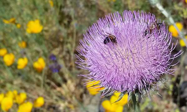
|
|
Those of us on the Butte hike had a lot of uphill, through wildflowers and some of the best groomed trails we had ever experienced. We were treated to views of the Four Peaks, Camelback, the Superstition Ridgeline and Weaver’s Needle, and miles of Tonto Forest on the north side. We reached the top, rested a minute, took photos, and started back down the mountain. |
Wildflowers were abundant: [photos by Quy]  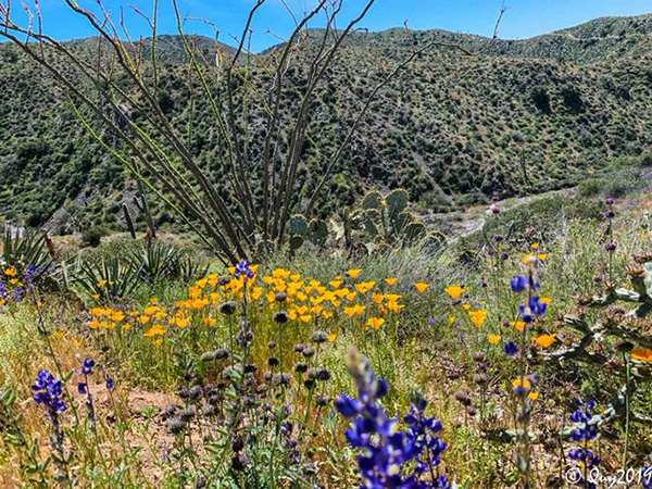
|
|
After a little over 2 hours of hiking, we were greeting at the trailhead with food trucks and a spread of salmon, chicken and angus sliders, salad, fries, corn cobs, and an assortment of macaroons. And, of course, a selection of beer and cold water. |
 Let’s celebrate! [photo by Wendy] |
 Enjoying our lunch after the hike. [photo by Quy] |
 Enjoying our lunch after the hike. [photo by Tom] |
|
We met other hikers, heard more about the facilities at the Ranch at Desert Mountain—a glamping site, mosaics, and horseback riding. We enjoyed our meal, met a few horses, and started back down to reality. The only way to hike these trails is by invitation by a member, so if anyone who lives in this beautiful community wants to be my friend ... → More pictures, by Quy.→ More pictures, by John. |
|
Supplemental Report by John Scruggs |
|
|
|
On Sunday, 4/7/2019, our hiking club, the Arizona Trailblazers, was invited to send up to ten hikers to participate in the 2nd Annual Desert Mountain Hiking Invitational. Once a year the Desert Mountain hiking club, the Desperados, invites other hiking clubs to have a go at their private hiking trail system in the mountains about six miles northeast of Carefree. This year they hosted seventeen “Outsider” hiking clubs. Hike five has the greatest elevation gain, 1,423 feet. We hiked about 2.2 miles up and then 2.2 miles down. Our highest elevation was 4,416 feet. John |
||
 Lots of flowers beside the trail. [photo by John] |
||
 We’re climbing to the top. [photo by John] |
||
 Don’t tread on me. [photo by John] |
||
 Top of Page
Arizona Trailblazers Hiking Club, Phoenix, Arizona
Comments? Send them to the AZHC .
updated April 10, 2019