Outdoor Links
Hike Arizona
Trip Planning Guide
Trip Report Index
Calendar of Events
Library
|
Hawes Trails Day Hike Usery Mountains March 30, 2019 by Michelle Jelsma |
|
 The Fabulous Five. [photo by Quy] |
| Bettye, Pete, Michelle, Mark, Quy |
|
After some cancellations, five hikers gather to explore the Usery Mountains. We get an early start with boots on the trail before 6:30. We start out going west on the Lone Mountain Trail. Our first couple of miles is all uphill with dips in and out of the washes. It is a beautiful morning with the temperatures in the low 50s. |
 The sun peeking out from behind the mountains. [photo by Quy] |
 Pete preparing for the sun. [photo by Michelle] |
 Michelle taking it all in. [photo by Quy] |
|
As we crest our first peak of the day we can see Fountain Hills, and the views of the valley below are vast and beautiful. |
 We can see for miles. [photo by Michelle] |
|
After stopping for a quick break to take in the views and catch our breath, we continue on. The trail goes down now with lots of scree and no rocks for stepping. Some of us decide to do some bottom scooting to get down the slippery slope. |
 Watch your step! [photo by Quy] |
 Bettye does the butt scoot. [photo by Quy] |
|
It isn’t long before we are climbing up again and into an area where none of us have been before. We enjoy the views as we hike along, in and out of the sun, eventually cresting another peak. Here the trail goes in two directions. We opt to go to the right, going in the direction of the Hawes Trails. We quickly come upon a sign that tells us we are on the Upper Gidro Pass Trail No. 65. |
 Up, Up we go. [photo by Michelle] |
 Find lower Gidro pass. [photo by Michelle] |
|
We meander along the ridge line for a ways before we start down the other side of this peak we have discovered. The west side of the mountain has a much rockier terrain with large boulders scattered throughout the mountainside, and the desert is yellow with blooms of the brittlebush and creosote. |
 Hole in the rock. [photo by Quy] |
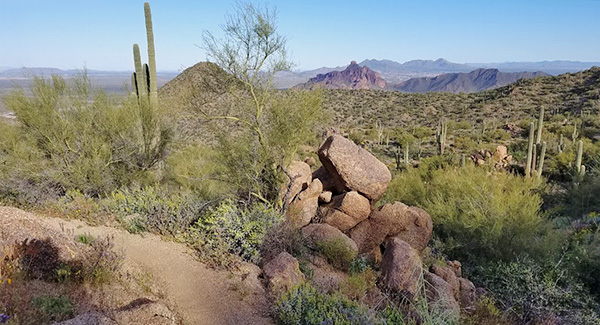 Rocks everywhere. [photo by Michelle] |
 This looks like a good spot for a picture. [photo by Michelle] |
|
We work our way down the mountain, switching back and forth, enjoying the many formations made by the rocks and boulders. We eventually come across the sign for the Lower Gidro Pass trail and figure we must be heading in the right direction. The trail descends into a wash area where we find enough shady spots for us to sit and take a snack break. |
 What a beautiful day for a hike! [photo by Quy] |
 Which way do we go? [photo by Michelle] |
 This saguaro looks confused. [photo by Michelle] |
|
After our snack break Mark gets started first, and before we know it he is calling for a camera. He has almost stepped on the rattler on the trail with the shade keeping him camouflaged in the sand. We keep our distance while trying to snap pictures and wait for the rattler to leave the trail, with a little coaxing. Just as we think we are in the clear, we hear the second one rattling. We check the desert below us and find a safe route around the trail where the rattlers are wont to lurk. |
 Glad he heard us coming. [photo by Michelle] |
 I want to be on that trail. [photo by Quy] |
|
With our adrenaline pumping we forged on. The last 2 to 3 miles consisted of lots of ups and downs. We made our way down another steep trail with nothing but scree from the many bikes that use these trails. A few spots had us but scooting again. We made our way to the Saguaro Trail, where we went east and made our way up to the junction with the Twisted Sister Trail. We continued on the Saguaro Trail and climbed up to the quartz mine, where we continued over the peak and back down to the Bush Highway where our car waited for us. We were all able to fit in Michelle’s car to get us back the starting point. |
 Slippery trails scattered with scree. [photo by Quy] |
 The Salt River flows. [photo by Quy] |
|
8.4 miles, 1482 AEG. → More pictures, by Michelle.→ More pictures, by Quy. |
 Top of Page
Arizona Trailblazers Hiking Club, Phoenix, Arizona
Comments? Send them to the AZHC .
updated May 27, 2019