Outdoor Links
Hike Arizona
Trip Planning Guide
Trip Report Index
Calendar of Events
Library
|
Massacre Grounds Day Hike Superstition Mountains February 23, 2019 by Tom Simonick |
|
 Superstitions, on a snowy afternoon. [photo by Tom] |
||||||
|
||||||
|
After watching the weather all week and experiencing two full days of rain and snow, fifteen hikers including two guests, were greeted by the snow-capped Superstitions, Mazatzal and Goldfields at the Crosscut trailhead. We were also greeted by a nearly full parking lot, as dozens of cars also lined First Water road and every small parking area between our trailhead and the Apache Trail turnoff. Once we got organized, we left the parking lot and started up the Massacre Grounds Trail. The temperature was around 45° but the sun was out, making for perfect hiking weather. We walked through backlit cholla and saguaro, set against the Superstitions. |
||||||
 It all began at Crosscut Trailhead. [photo by Kevin] |
||||||
 Start on the Massacre Grounds Trail. [photo by Lin] |
||||||
|
There were already many people on the trails, but spread out enough that we didn’t feel like we were constantly in traffic. Everyone was excited to be hiking towards the snow, while at the same time, we kept turning around to admire the snow covering Four Peaks and the Mazatzals. |
||||||
 Mighty chilly on the Four Peaks. [photo by Lin] |
||||||
 Fog hides the Goldfields. [photo by Kevin] |
 Cactus in the snow. [photo by Debbie] |
The trail was muddy and churned up in spots, but what was really noticeable was running water, often just a trickle, but more substantial in many normally dry stream beds. What also struck us was how green the desert was, with poppies and other wildflowers already evident. After a climb to a low saddle, we took three group pictures with different backgrounds: Superstitions, Mazatzals and no snow. An hour later as we approached the Massacre Grounds ridge, we were walking in snow, with occasional patches of ice. The snow was thin, but deep enough that you could scoop it up for snowballs. We took our first break on the ridge while Micheal told us the history of the conflict between Peralta miners and Apaches (the miners lost). |
 The streams were flowing. [photo by Carl] |
 Lupine. [photo by Lin] |
|
The ridge offered a view into the Superstitions including a snowy Weaver’s Needle. By this time clouds had formed, but they added to scene and contrasted with the blue sky and snow. |
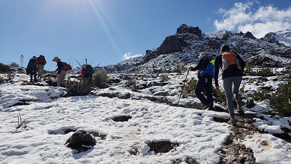 Trailblazers hiking in the snow. [photo by Lin] |
 Made it to the Massacre Grounds. [photo by Lin] |
 Chris and friends. [photo by Chris] |
|
After leaving the ridge, we continued up. At this point the Massacre Falls was easily visible because of the volume of water flowing over it. |
 Yes, we saw a waterfall. [photo by Tom] |
 There’s the waterfall. [photo by Chris] |
 Li is seemingly holding the water from the falls. [photo by Lin] |
|
We also had a beautiful view of the Praying Hands rock formation. There were plenty of other hikers heading up to the falls, packing down the snow and making the track a little slippery. After slipping a few times on ice and snow, I was really happy that we were not attempting to hike up Siphon Draw. Arriving at the falls, we proceeded to shoot many photographs. |
 Debbie and Neil at the Massacre Grounds. [photo by Li] |
|
Proceeding down the trail, we came across other Club hikers out on their own, including members of “Bill Z.’s Thursday Group.” It was nice to see Chris, Bruce and Gary, among others. |
 We met some friends on the trail. [photo by Tom] |
|
We continued to a point where Michael thought we could pick up a social trail that would take us to the Praying Hands. We said “goodbye” to Chris and her friends, as they headed back to the trailhead. After a short amount of time, we found several cairns heading in the right direction. While there were a few people on the trail, we had left the crowds behind and space opened up as we headed west. We stopped for lunch and then continued following the trail with Mark and Michelle in the lead to Slot Rock. |
 Heather climbs the Slot. [photo by Tom] |
 Praying Hands. [photo by Debbie] |
 Hiking the Saddle. [photo by Tom] |
|
Slot Rock has a large slot through which you can scramble up to a saddle and continue to another rock formation, before turning towards Praying Hands. Some of us choose the slot, others skipped it and headed for the saddle, but Michael and Carl started bushwhacking directly towards Praying Hands. In the end, we all made it to Praying Hands along with plenty of other hikers. |
 Lin at the Praying Hands. [photo by Li] |
|
Leaving that rock formation behind, we head down the trail towards Lost Dutchman State Park, before turning northeast via the Treasure Loop Trail and returning to where we began using the Jacob’s Crosscut trail. Arriving at the trailhead a little after 2 pm, we found the parking lot and road were still full of cars. The biggest surprise came when we headed towards lunch, westbound on the Apache Trail: the eastbound traffic was bumper to bumper! After hiking, eating lunch becomes a priority and everyone enjoyed the food at Uncle Bear’s Grill and Tap in east Mesa. Thanks to Michael for leading the hike, Debbie’s suggestion to use the Crosscut Trail, and to Michelle and Mark for leading us to Slot Rock. My statistics for this hike: 7.6 miles in 5h 40min, with an accumulated elevation gain of 2000 feet and an elevation change of 1174 feet. |
 Uncle Bear’s Grill and Tap. [photo by Lin] |
|
We had hundreds of great photos from this hike. Here are the links: → More pictures, by Tom.→ More pictures, by Kevin. → More pictures, by Debbie. → More pictures, by Li. → More pictures, by Lin. → More pictures, by Carl. |
 Top of Page
Arizona Trailblazers Hiking Club, Phoenix, Arizona
Comments? Send them to the AZHC .
updated February 27, 2019