Outdoor Links
Hike Arizona
Trip Planning Guide
Trip Report Index
Calendar of Events
Library
California
July 20-28, 2019
by Lin C, John S, Chuck P, Scott G, Carl L, and Jade Y
|
Photos by Carl L, Jade Y, John B, John S, Lin C, Mohammed,
Mary G, Ralph G, Scott G, Wayne, Yanis, Ann, John B, Chuck, Diva.
|
|
Saturday, July 20, 2019: Phoenix to Barstow by Carl Lunde |
 overview map of the southwest region  Route from PHX to Lodgepole Campground via Kingman AZ |
|
Thirty people in twelve vehicles departed from the Phoenix and Flagstaff areas today for a nine-day Arizona Trailblazers car camping trip. Two vehicles left from the I-17 and Bell Road Denny’s location at 9 AM, while the others left at various times from various places (PHX area and Flagstaff area). Our route took us up I-17 to Hwy 74 and over to Wickenburg and US 93 to I-40 and Kingman AZ. This was our first meetup point. Where we had lunch, many of us at Mr D’z Route 66 Diner, and a few others had lunch at a couple of other lunch spots nearby. The Diner is filled with a lot of Route 66 memorabilia. We then visited the Arizona Route 66 Museum and the Powerhouse Visitor Center. A lot of interesting facts about Route 66 (aka “The Mother Road”). There is also a movie about the history of Route 66. In addition, there is an electric car exhibit that shows electric cars that go way back. |
 Route 66 and train in Kingman |
 Lunch at Mr. D’s Route 66 Diner |
 Police car from the 1950s in Kingman |
 Chuck, Carl, and Jade are waiting for FOOD |
 Nicole, Gary, John, and Wayne are hungry |
|
Many of us filled up with gas here to avoid the extra buck or so that gas costs in California. At various times during the afternoon, people left the Kingman area to head to Barstow, where beds were waiting for us. The route to Barstow was all along I-40, which goes between Joshua Tree National Park and Mojave National Preserve. Our first night’s lodging was at the Ayre’s Hotel in Barstow, California. We got to Barstow at various times, but most were there around 5 PM. Then we had dinner at Chile’s that evening, most of us retiring early after a long day of driving and sightseeing. |
|
Sunday, July 21, 2019: Barstow to Sequoia National Park by Carl Lunde |
|
Sunday morning, about 7 AM, we had a great breakfast at the Ayre’s Hotel in Barstow and got underway for the final leg of the trip to the Lodgepole Campground in Sequoia National Park. |
 Chris and Joe enjoy their meal at the hotel. |
 Breakfast—most important meal of the day. |
 Breakfast. |
|
From Barstow to the Campground, most folk went the shorter but far more windy way. John, with his trailer, elected to come in from the North, through Kings Canyon National Park. |
 Sequoia and Kings Canyon National Parks—Regional Map |
|
Leaving Barstow, we took Hwy 58 through Kramer Junction and the north side of Edwards AFB and near China Lake Naval Air Weapons Station. We also went by Mojave, where a lot of private airplane and rocket testing has occurred. It is the home of Rutan Voyager, the first aircraft to fly around the world nonstop and unrefueled. We then drove on to the outskirts of Bakersfield. Buck Owens, Merle Haggard., and others were raised there. Bakersfield, by many, is considered the “birthplace of country music” which is interesting as the “Bakersfield Sound”, a twangy style of Fender Telecaster and pedal steel guitar music made popular by hometown country Buck Owns and Merle Haggard. Interestingly, Bakersfield is known for Doowop music dating back to the 1950s (The Paradons, The Colts, The Rev-Lons, etc.). |
|
We then took highway 65 up towards Visalia and into Three Rivers. We filled up with gas in Three Rivers. Several of us ate lunch at Sierra Subs & Salad, a very good little lunch place. The sandwiches were tasty. The place was crowded and very busy. Meanwhile John went north—because he was towing his trailer—leaving us at Exeter and heading on Hwy 245 and up to Grant Grove and into Kings Canyon NP and then down to the Lodgepole Campground. The drive after Three Rivers along Hwy 198 got very curvy, with many tight switchbacks. John and his Jeep crew stopped at the Indian Trading Post just outside of the park entrance. In addition to gas, some homemade tamales were on order. |
 Highway 198 (Generals Highway) in Sequoia NP |
 Jeep side trip to the Indian Trading Post, the tamale vendor who also sells crafts. |
 John’s Jeep and trailer. |
|
We arrived at the Lodgepole Campground in the early afternoon and set up our tents at the twelve campsites that we had booked six months in advance. Lodgepole Campground is quite large and a very busy place. There is a Lodgepole Visitor Center and a Lodgepole General Store and laundry and showers. There is a shuttle service available, which we used for some of our transportation to a couple of hikes at very crowded trailhead parking lots. |
 Lodgepole Campground Map. The yellow highlighted areas show (approximately) our campsite, the red area our campfires and potluck meals. |
|
Our campsites were all very nice and we had most of the campsites in one area, thus allowing for a great area to set up for our potlucks and our campfire evenings and guitar/singing entertainment. The photos below speak for the campsites and the campfire evenings. |
 Mary, giving orders to dudes moving the campground table. |
 A view of our campground from the hill. |
 Gary and Chuck relaxing at their campsite. |
 Preparing our campfire site. |
 Lin and Carl’s tent (background) and Jade’s tent (foreground). |
|
After setting up camp, we went for a hike to Moro Rock. See the following report section. In the evening, after the Moro Rock hike and dinner, we had a group campfire and singing session. Jade, Rudy, and John S, all provided great guitar and singing entertainment for our group. They are a very talented bunch. By 10 PM, everyone was tired and went to bed in preparation for our next day’s hiking. |
 Our first campfire evening. |
 Jade, playing the guitar and singing. |
 Rudy, singing and playing the guitar. |
|
Sunday, July 21, 2019: Moro Rock by John S. and Lin |
|
Moro Rock is a prominent granite dome located in the center of Sequoia National Park between Giant Forest and Crescent Meadow. A 400-step stairway, built in the 1930s by the Civilian Conservation Corps, enables park visitors to hike to the top. The stairway is listed on the National Register of Historic Places. |
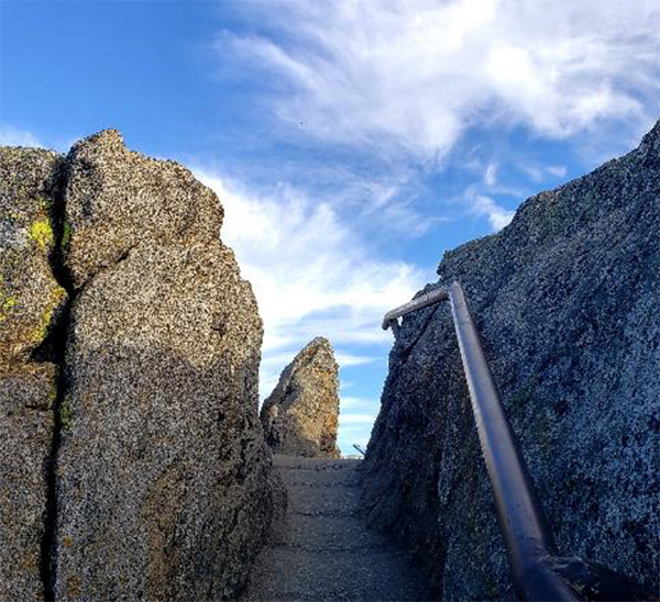 Top of the 400-step stairway. |
 Our first hike was to Moro Rock. |
 Here comes happy John S. [Yes, I made the ascent carrying only my camera and water bottle]. |
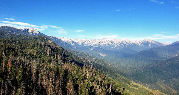 The view up into the mountains toward Sequoia NP reveals the ridge over Lodgepole Campground. |
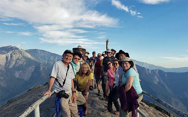 Everyone who made it to the top of Moro Rock before we took this photo. The precipice beyond the railing behind us is 1400 feet down. |
 A preview of coming attractions: The Trailblazers will return to Moro Rock for sunset soon. |
|
Look for the Moro Rock Sunset Hike report in five days ahead. |
|
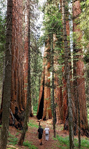
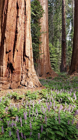
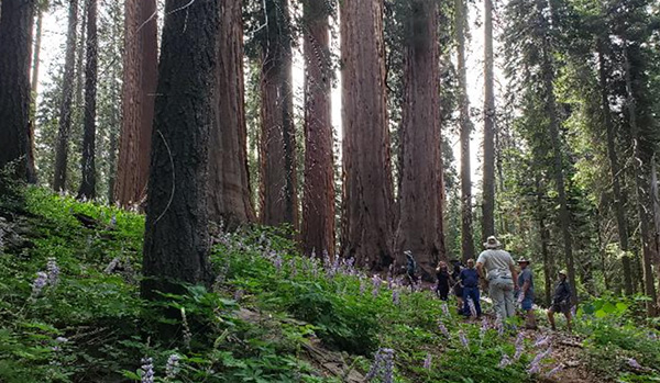
Monday, July 22, 2019: The Congress Trail by John S. |
|
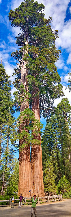
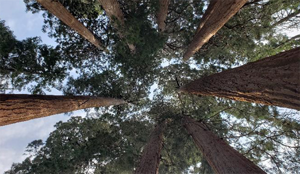
The Congress Trail starts at the General Sherman Tree, largest tree in the world, and goes about a mile south to an impressive collection of immense sequoias, a few of which look just as big as the Sherman Tree. Also, at the south end of the loop are two unusual groupings of somewhat smaller sequoias, the House and Senate groups. |
||||||
 Everyone is getting ready to do our first real hike (sorry, Moro Rock). We are going to see the largest living things on earth today! |
||||||
 We all wait at the Lodgepole Campground Shuttle Station. The sun begins to warm us up. |
||||||
 STOP! Our tall John is too tall to walk through this tunnel without a respectful bow. |
||||||
 Group picture at the world’s largest tree: General Sherman |
||||||
|
||||||
 Deirdre and Jim are enjoying this Congress Grove. |
||||||
 Hi, Jade ... |
||||||
 The President Tree. |
||||||
 Maria, Mimi, and Cheryl |
||||||
|
At this point, our leader, Lin, broke us up into smaller groups so we could wander about on our own. Remember, not all who wander are lost. |
 Karen is change of this group. |
 Mary is in charge of this group. |
 Ralph is lost in this group of Sequoia. Who’s in charge of Ralph? |
 Some trees bear the names of great people from the first nations. |
|
Chief Sequoyah (c. 1765-1843) is the Cherokee Native American who created an alphabet of 86 syllables for the Cherokee language in the early 19th century. Sequoyah is the only person known to have invented a whole alphabet, which he used to record the history of his tribe. The sequoia giant redwood trees of California are named after him. |
 One awesome group at one awesome & HUGE tree. |
 Jim is in charge of this group. |
 Time for break: Yanis, Deirdre, Jim, Mimi and Karen. |
 This looks like a perfect spot for lunch. Faith and Rudy take advantage of the shade of a giant. |
 Our hike ends at Crescent Meadow near the south end of the park and very near the lowest altitude in the park. |
|
As a child of eight, I rode with my parents in a 1954 Chevrolet through an arched tunnel cut through a living Sequoia tree. I knew that the park had put an end to driving through the tree and I seem to recall hearing that the old tunnel tree had died and fallen. As I planned for this trip I kept hearing that one could still drive through a tunnel in a giant tree. |
 John drives his Jeep through a tree the size of a house. |
 There are trees you can walk through. This one goes crosswise but some can be traversed lengthwise. |
 There are trees you can live in. Take for example, the Room Tree. |
 Is it the home of some fairy princess? The lair of a pixie or an elf? Yes! It’s Mimi! |
 The Room is quite roomy and the ceiling is beyond the reach of my camera flash. |
 Nature’s flower arrangement, with lodgepole pine and its fungi. |
 Speaking of fungi, what is this? An alien spacecraft the size of a tennis ball? |
 The Hand of God? Who knows what has transpired here the last 5,000 years or so? |
 They are stuck in the tunnel, waiting to be fed. |
|
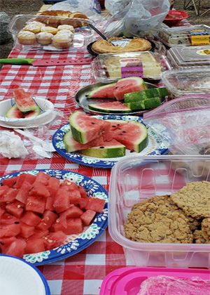
Monday, July 22, 2019: Potluck and Campfire by John S. |
|
The Camp Potluck is an Arizona Trailblazer tradition. Each camper brings his or her own specialty and everyone eats until they must quit and go to their tents to sleep. Then we start all over the next day with leftovers. Sometimes, if the mood is right and the moon arises, there is a bit of music to sooth the savage beast. |

|
|
| The food is ready. Yum! | |
 Everyone is enjoying the potluck. |
 Mary is checking out the food. |
 Big group, with 31 of us. |
 Ann, do you want to try this? |
 Mimi, Faith, Carol, Michael and Chuck are full. |
 Here comes our Rudy and Jade. |
 What a perfect pair [Delighted to have time for several sets with Jade. She can really harmonize!] |
|
Tuesday, July 23, 2019: Kings Canyon by John S. |
|
Our Trailblazers road trip adventure for the day began on the General’s Highway heading north, further up into the mountains of Sequoia National Park. After we left Sequoia NP at Big Stump, the northern park entrance, we merged on to the Kings Canyon Scenic Byway (highway 180) and headed into that National Park. Our instructions were to travel independently, each car stopping at will to see any of the amazing sights that are plentiful and beautiful. We all stopped to see the trees in the General Grant Grove. I had an idea about Hume Lake that I wanted to check out, so the Jeep crew took a side trip, which took us farther off the road than we expected. We did a drive-by visit at the Hume Lake shoreline. We did not drive into the village of Hume, but I heard from others who visited a few days later that it was worth the trip. We returned to the Kings Byway, after a stop for some flower photos, and caught up with the rest of the cars in time for our rendezvous at the King’s Canyon Lodge. As we continued down the canyon, the Scenic View signs came along more frequently until it seemed that every turn could be a great photo opportunity. We had to resist the urge to stop too often so we could keep on schedule. We ate lunch at the Cedar Grove Visitors Center. We took a short walk off the road to Knapp’s Cabin, which overlooks Kings River. We drove to the end of the road and climbed out for one last short hike around Zumwalt Meadow to have a look at the Roaring River Falls. It was a pleasant drive. The traffic was not bad at all, once we got past the intermittent road repairs on the General’s Highway. Leader Lin could not suppress a jump for joy. |
 Trailblazers group photo at General Grant Grove. The twin Sequoias on the right were the backdrop for the previous photo in this report . |
||||
|
||||
 Maria, Yanis, Cheryl, Karen and Mimi, at Panoramic Point with Hume Lake in the background and Kings Canyon in the distance. |
||||
 Yes, there is a cell phone signal here. |
||||
 We all put our phones down for a group picture. |
||||
|
||||
 From Panoramic Point, looking NE into upper Kings Canyon, with Hume Lake in the foreground. |
||||
 From Hume Lake with Panoramic Point in the upper right at the horizon. This shot was the inspiration for our side trip to the lake. |
||||
 Hume Lake Road. While John S. takes photos of flowers, Wayne gets the good shot into Kings Canyon. |
||||
 I decided to take the same shot, once I realized I could include some of the flowers that covered the hills where we stopped. |
||||
 Another view into Kings Canyon from a point on the Kings Byway aligned with Hume Lake. Hume Lake is drained by Ten Mile Creek, which flows into the South Fork of Kings River. |
||||
 A world of Cairns. Please walk softly, Mimi and Maria. |
 Maria and Mimi |
 waterfalls |
|
Sisters Maria and Mimi met at the park to bond. Now they are stumped. There’s a light at the end of the Tunnel Tree, Ladies. Waterfalls above the Kings Canyon Scenic Byway. Could this be Ten Mile Creek bringing water from Hume Lake? |
 Some of the mountains are rather stark, which suits this scene with the weather front moving in. |
 Rudy enjoys the view. |
|
Rudy is enjoying this moment at Junction View. Perhaps he is waiting for a break in the clouds for a few bars of cell service. The confluence of Ten Mile Creek into Kings River is visible below, as is the road we will take down into Kings Canyon. |
 Break time at the Cedar Grove Visitor Center. |
 Lunch looks good. Chris, Michael, Carol and Faith. |
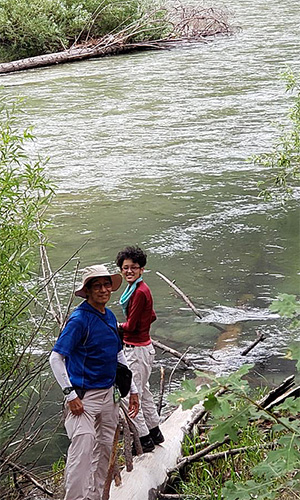
 Ann and John B, blue love birds on the bank of Kings River. |
 Knapp’s Cabin on a hilltop above the river. Carl and I wonder what Jade is thinking. |
 Yes, of course. Jade is a climb-anything Trailblazer, after all! |
 Knapp’s Cabin |
|
Carpenters and architects must admire the primitive but well-crafted nature of the cabin. It was constructed of local materials including lodgepole pine beams and framing with large, sturdy, sequoia shingles. “The one-room cabin was built in 1925 by George Owen Knapp, founder of Union Carbide. Knapp used the cabin for storage while camping in the area. After Knapp stopped camping in 1928, he no longer used the cabin.” [Wikipedia] |
 Kings River at Kings Canyon is navigable in sections. This would be at least class 4 rapids. |

|
|
| Deride, Karen and Mimi on a bridge over troubled waters, while below, kids have fun down by the river. | |

|
|
|
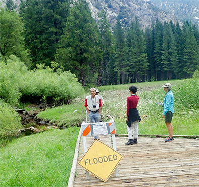
Here’s Capitan John, strollin’ through the ferns in the
riparian marsh around Zumwalt Meadow, parts of which are flooded. |
|
 Road’s End! Bears are coming! |
||||
|
|
Wednesday, July 24, 2019: The Lakes Trail by John S. |
|
Our hikes today take us up above the Lodgepole Campground to the top of the watershed for the stream that runs past our tents and soothes us to sleep each night. The Marble Fork of the Kaweah River drains numerous ice-carved pools at the top of the ridge surrounding this fan-shaped basin. The Lakes Trail, one of the most popular trails in the park, will take us almost 3,000 feet up the mountain to this lake district at around 10,000 feet elevation. We rendezvous at Heather Lake where we eat lunch and split up into two groups, a short hike group that will descend to complete the 7.6 mile loop, and a long hike group that will continue to hike on and visit three more lakes before returning to the shuttle stop via Heather lake and the Hump Trail to complete their 11.8 mile loop. |
 Satellite view, Lodgepole to Pearl Lake, showing the terrain and the elevation change for the Lakes Trail. |
|
The first hike group, the “Speedy Hikers”, set off a 7:00 AM in their cars to begin before the shuttle traffic brought a crowd that might clog up the trails. We could see signs of their passing, especially on the way down on the Hump Trail. Literally, signs, in the form of stick figure arrows made out of sticks and averaging three feet in length. I heard Chris say something about the early group leaving them, to show us the way up the Hump Trail. They did not realize our plan was to go the opposite direction around the loop. To the best of my recollection this was the first time I have defied the arrows and gone the wrong way on a one-way trail. Lin’s account of their long hike adventures appears at the end of this short hike section. The second group of not-so-speedy hikers set off from the Lodgepole Visitor Center on the first shuttle at eight. When we arrived at the Sherman Tree Trail shuttle stop, we found out that our next ride, the Wolverton shuttle, did not start service until 9:00 AM, so we had some time to kill. |
 Waiting for the Shuttle. Wayne, Ann, Ralph, Nicole, Michael, Lin, Diva and John S. |
 Long wait for the Shuttle. |
 The ladies have challenged the men to do yoga appropriate to our venue. Not Bad! Right? |
 Four Ladies leaping, looks a bit like the YMCA dance but they are spelling out YAHT as in, “Is the shuttle here yaht?” |
|
Finally the Wolverton shuttle arrived, right on time, and took us to the trailhead. We started up the almost continuous steep slope toward the Watchtower. |
 The Lakes Trail topographical view looking down on Pear Lake. |
 As it turned out, Nicole and I were the two short hikers, which suited us fine. |
 This wall and precipice is the Watchtower formation from which the trail takes its name. What a view! |
 The Watchtower formation as seen from the bottom of Marble Falls on the Tokopah Trail. |
 Here comes tall John again. [What? You never had a hippo rest his chin on your head?] |
 The Marble Fork of the Kaweah River is one continuous waterfall. |
 The Watchtower trail comes this close to the Marble Falls. Anyone thirsty? |
 Watch out everyone! There is some legitimate exposure along this stretch of trail. |
 March on, Ann. The air is getting thinner and the trail is still quite steep. |
 Ralph, Ann, and Wayne. Also, the trail is getting rockier. |
 Heather Lake |
Nicole and I waited at Heather Lake for a bit, awaiting the return of some of the other hikers who might turn back after a lake or two. We soon decided that the swarms of mosquitos and the sound of distant thunder were signs that we should start down the trail. We crossed over a high ridge above heather lake and descended back to the Wolverton shuttle stop along the Hump Trail. A good hike for a Wednesday. There were no more vistas like those we passed on the way up but there were some lovely flowers and a rare butterfly to catch our attention. The rain held off while we shuttled back to the Lodgepole Visitor Center shuttle stop. It hit with some fury the moment I stepped off the bus. By two steps I was soaked, and it started to hail. Too late to put on a poncho, I gritted my teeth against the chill and tromped off to my tent for some dry clothes. I never saw where Nicole wound up after the shuttle. |
 A rare white Western Tiger Swallowtail butterfly pales in comparison. |
 A Snow Flower emerges. |
 The Snow Flower blooms are quite radiant. |
|
Wednesday, July 24, 2019: The Lakes Trail Part II (Heather Lake to Pear Lake) by Lin |
|
After a quick lunch at Heather Lake; Ralph, Diva, Ann, Wayne and I continued to our next lake, Emerald Lake. From Heather Lake to Emerald is 1.2 miles with more than 300 ft elevation gain. We followed the trail as it climbed above the hillside on the east of Heather lake and then curved around the end of a ridge. At this open area you have great views of valley and up the Marble Fork Canyon. About at this time, we met the first few of our Fast and Earlier group hikers coming back from Pear Lake (they started their hike at 7 AM). It is funny how we react when we met other hikers on the trail. We gave each other hugs and high fives. It’s kind of like you have not seen each other for ages. That was exactly how we felt when we met Rudy on the trail. Rudy told us about the HUGE fearless Marmots at Pear Lake. We told him that the early group must check out the Watchtower Trail on their way down. They had planned to hike down the Hump Trail, the way they had ascended. After Ann, Rudy, and I hugged and took selfies we all went on our own separate ways. |
 Wildflowers at the hill that must be climbed to go beyond Heather Lake. |
|
Even though it is the end of July, we still see snow on the trail and along the trail. We walked on top of snow, watched melting water running beneath, listened to the sound of running water from the creek, and enjoyed the pink wildflowers on the hill. It is a great place to visit in middle of July. The air was getting thinner, the view of Alta Peak, 11,204', was getting better and closer. |
 Happy to see each other! Lin, Rudy, and Ann. |
|
Aster Lake, a granite bowl, is located north of Emerald Lake; to get there you need to hike a side trail (0.5 mile) at the 5.0-mile mark. We had very limited time today. Our focus was to stay on the main trail to get to the Emerald lake as soon as we can. Right before the trail turns to northeast, rounds the ridge, and begins moderate decent to Emerald Lake, we met rest of Fast and Earlier group of hikers. They were Scott, Ken, Chris, Yanis, and Mohammed. |
 Little Aster Lake |
|
At 1:20 PM we arrived at Emerald Lake. There were lot more people at Emerald Lake than Heather Lake. Some of them were kayaking, some of them were just sitting along the lakeshore, some of them were taking a break, and some of them were just lost in this wonderland. Wow, what a view! |
 Blue sky, white clouds, trees, and Emerald Lake. |
 One of the many waterfalls at Emerald Lake. |
 Diva is posing for a picture. |
 Is this a perfect place for kayaking? |
 A perfect view: white snow, pink flower.. |
 Melting snow on the hill. |
|
It is 1:30 PM, past our turnaround time. We had planned a 1 PM turnaround. The dark clouds were piling up in the distance. Pear Lake is about another 1.2 miles from Emerald lake. Should we continue to the Pear Lake or should we turn around to go back to trailhead? Ann, Diva, Wayne and I got together as group, we made decision we will stay together as group, and we will go to Pear Lake. As soon as we decided we were going to Pear Lake, we met Deirdre, who was on her way down from Pear Lake. After hearing her say how beautiful the lake is, we wasted no time starting our fast pace running on the trail. Just about 10 minutes into the run we met the park ranger. We asked the ranger, ”Is it safe for us to go to Pear Lake?” He looked at us and looked at the sky and said, “The lake is just around the corner. You guys will be there before the storm comes.” This section of trail was rocky and ascends on easy grades around the granite ridge running along the east side of the Emerald lake basin. If you turn and look at left, you can see the little Aster lake, which we did not visit. At the end of the ridge, the trail turned east and climbs a moderately steep hillside. The trail got rockier and the trees get thinner as we ascended into the Pear Lake basin. Since we were in such rush, I really did run on this section of trail. Later I remembered Ann said to me “Lin just took off and disappeared from our view.” And she was right. I pushed myself to the limit and went as fast as I could. All I remember was the granite slabs were everywhere, I really must watch each step to avoid tripping and falling. It was an awesome feeling when we reached Pear Lake. The view was breathtaking. We were so excited: happy, proud, tired and satisfied. Yes, Yes and YES to all above. The calm and quietness of cool air (the calmness before the storm), the crystal-clear lake, the snow-covered hill, the strong few trees around the lake, the high and fearless Alta Peak in the distance, and this perfect mirror reflection imaging from the lake. A priceless view. |
 “We made it!” Ann said. |
 What a perfect view! |
 “Yes, we did it!” |
 Can I jump into the lake? |
 Cold and fresh running creek. |
 Cross the creek to explore the other side of the lake. |
|
Wayne found a perfect location where we took a group picture at lake, we started our decent from the lake. Yes, the storm has moved in. We must leave now. Diva, Wayne, Ann and I would like to explore more of this lake, but we must wait to next time. |
 Fearless Wayne, Diva, Lin, and Ann. |
|
Right after we ran past the granite, a ridge, moderately steep hillside, it started to rain. The thunder was getting closer too. We were out of open rocky hillside, but it still faced danger from lighting. Diva ran the fastest. Ann and I were together. “Where is Wayne?” One of us asked, we did not see Wayne anywhere near us. We radioed Wayne “Wayne, where are you? are you OK?” “I am behind you guys, I had a leg cramp.” “Drink water, eat some salty food. We will wait for you.” So, Diva, Ann and I stayed out of open area, dodge near big tree and boulder wait for Wayne. After few minutes, Wayne appeared from the corner of hill on the trail. While we were waiting, Diva, Ann and I went through our backpack try to find some food has good source of potassium for relief cramp leg, and we found dried banana chip (has potassium, magnesium, and calcium), granola bar, Ritz cracker. Wayne looked OK, but three ladies still forced him to drink water, eat banana chips. Wayne is a strong hiker. I have been hiking with him for many years, he never had leg cramp or fatigue. Later we found out, Wayne forgot his mustard which he always carries with him while he hikes. Sequoia NP is bear country, they have very strict rule at campsite, you must store all your food into animal-resistant food storage container at night. We follow the rule very well, right, but sometimes we forgot to put the necessary food or snacks back to our backpack, just like Wayne did this morning. After few minutes of resting, he was feeling better and we were all ready to run again. |
 Moss grows on the trees. |
|
At the trail junction we had a choice of turning right and following the Watchtower, or turning left and following Hump Trail. The Hump Trail is lot steeper and half mile shorter than the Watchtower Trail. It also less exposure because more tree on this section. We all decided we were going down on Hump Trail. The thunder and lightning were rolling away from us, but the rain was getting harder and harder. Knowing people at campsite may worry about us, we need to let them know we are doing fine and will be out of danger soon. Diva is an ironman, the strongest of all, so we decided sent Diva go back to campground first and let other know that we were fine. We gave Diva a Walkie-Talkie and sent her away on the trail. She started to run. In the meantime, Ann, Wayne and I were hiking together. No, we were trail runner together. This section of trail, trees was tall and dense, after few minutes, Wayne was behind us again. We radioed him again “Are you ok Wayne?”; “I am fine, you guys keep going, do not wait for me”. “No, we will stay together”. For next half hour so, we keep press on and keep running, we keep radio each other every few minutes. We were tired but our spirit was high. 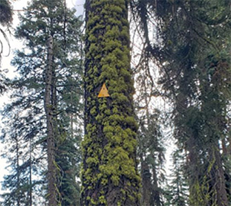 Green moss and yellow arrows. At 5:43 PM we were back at the trailhead. We were wet, tired, but very happy and grateful. The last shuttle is 6 PM. We waste no time, walk very quick back to the shuttle station and wait. Today is a funny day. We get up early but have to wait for the shuttle. We run all the way back to trailhead, but we have to wait for the shuttle. And it was the same driver who drop us off and pick us up. And he remembers us as soon as we got on the shuttle – “What happen to your group? I picked up one guy first, then two, then one and now your three? What happen to other one?” Wow, he remembers exactly how many of us? We told him, everyone is safe and one of hiker get ride from another hike (Diva got a ride from Deidre). Then he told us, how happy he was when he saw the rain came today, he said it has been very dry for last few months, and this was the first real rain for this area. Wow, what can I say? This is going to be one of most memorable day in my life. The beautiful trail, the breathtaking view of Watchtower, the crystal-clear lakes, the snow, the pink flower, the Fat marmots, the thunders, the run and laugh and that wait in the morning and afternoon. Thanks for the wonderful day. So grateful that everyone was safe and happy. |
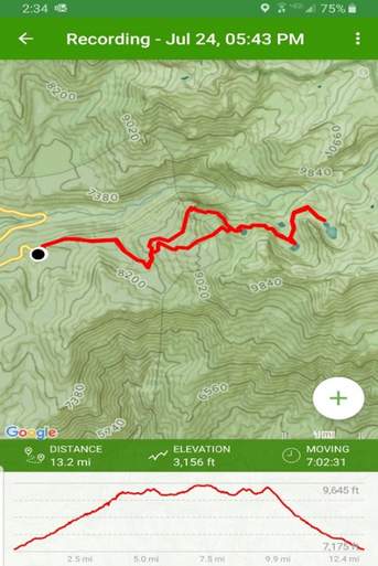
 GPS Map |
 Elevation Profile |
|
ALLTrail Record |
|
Wednesday, July 24, 2019: The Lakes Trail (Earlier Group) by Scott G. |
 Group Picture at the trailhead. |
| Yanis, Mary, Ken, Chris, Rudy, Mohammed, Scott |
|
The club’s hike to Pear Lake was organized into two groups. The named “fast” group of seven was misnamed. The seven actually represented those who normally woke up early and who were not keen on hiking any more than necessary during the warmer afternoon time period; we were not necessarily faster than the later club group. |
 Mary is crossing the creek while Scott waits. |
 Chris and Ken at the creek. |
|
Us seven, looking giddy in our trailhead picture, were ready to meet any challenge for the day. The trail was to take us up, up to Pear Lake with many sites in between. After a couple of miles we came to our first decision point: left to the Watchtower or right to what is referred to as the Hump. After a discussion, to the right we went. Whereas the trail to the Watchtower was a route to go around the tall hill, the trail to the right was rightly named, as it was indeed a hiking climb and steady trod up the dirt path. The end of the Hump though popped us out of the trees and presented our first of many wow views! It was our first view of Marble Fork of Kaweah Canyon. The view was to be representative of what we saw the remainder of the day: gray granite, melting snow fields, water streams and rivers, and the personal feeling of nature’s wonder. |
 First view of Marble Fork of the Kaweah Canyon (Mary, Rudy, Chris, Mohammed). |
 A grouse at the trail. |
 Emerald Lake |
|
Continuing on, we saw a bird unfamiliar to most of use which we decided was a grouse. This was just one example of animal sightings which are not found or easily seen during our normal hikes in Arizona. Approaching Emerald Lake, we were able to see Aster Lake toward our left but the trail took us directly to Emerald Lake. Emerald is the first opportunity for overnight stays and the campground area was lightly populated with tents and campers within an area of tall trees. Chris went into the campground to investigate, while the rest of us took a sharp left turn to continue up across a gray, sparse mountainside, which allowed us to see behind Chris continuing along the trail as we headed to Pear Lake. |
 Pink flowers greet us along the trail. |
|
Pear Lake was exceptional with mini icebergs, granite peaks surrounding half of its circumference with a zone of snow between the peaks and water. The opposite half was an open, flat granite area for tents, and a view of Kaweah Canyon with its tall sierra mountains and peaks. |
 Always full of energy, Ken is marching down the trail. |
 Yanis enjoys his time at Pear Lake. |
 “Watch out, Mary!” |
 Welcomed by local residents, marmots. |
|
We saw two resident Marmots who obviously kept the area clean of anything eatable. We also met a lady born in Germany and now working in London who spent overnight. We asked which route she was planning to return on, either the Hump or the Watchtower? She said the Hump because the Watchtower Trail was too narrow and had precarious drop-offs. From this description and the slight chance of rain as we had experienced on previous afternoons, the plan was to return the way we came via the Hump. |
 Group Picture at Pear Lake. |
| Mary, Rudy, Scott, Mohammed, Chris, Ken, Yanis |
|
On our way back we again stopped at Emerald Lake but took more time to investigate the lake and granite shoreline. Yanis found a perfectly round hole which had the depth and familiarity of an Indian grinding hole, substantiated by these articles: Grinding holes in the Sierra Foothills and Indian Grinding Rock State Historic Park. After leaving Emerald Lake, we again retraced our steps and fortunately met up with the club members who had started later in the morning. When they started, they bypassed the Hump Trail by taking the Watchtower route. They each exclaimed in concurrence that our group absolutely needed to return via the Watchtower route due to its magnificence. With blue sky and the insistence of the others, we took the right fork in the trail toward Watchtower. The trail paralleled Kaweah River but from thousands of feet above. The trail was indeed narrow but we have hiked without injury more perilous trails. We passed other hikers with fishing equipment and kept our sense of awareness traveling slightly downhill. Once to the Watchtower area, we met others and had our picture taken as we enjoyed our time while some in the group contemplated the successfulness of walking out on a rock fin hanging over the canyon. That fin is the Watchtower formation. |
 Grant view of the waterfalls. |
 White snow, blue sky, and yellow flowers. |
 Group Picture at the Watchtower. |
| Ken, Chris, Mary, Rudy, Mohammed, Scott, Yanis |
|
We said our goodbyes and continued on the trail, now downhill, back to the parking lot. The trail was shady with moist ground which was welcoming given the now warming afternoon. Rudy even decided that a steam was too cool to pass up an opportunity for a little personal self-cleaning. As we continued down we started to string out as some enjoyed the quicker downhill while others wanted to enjoy the time longer. Once in the parking lot, some collected firewood while others chickened out and left sooner for a shower and relaxation at camp. |
 Rudy is totally enjoying himself at the creek. |
 Map of the Lakes Trail. |
 Elevation Profile of the Lake Trail. |
|
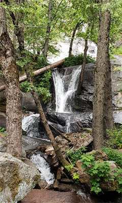
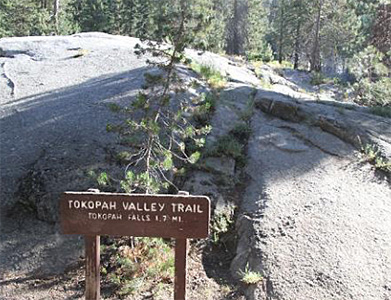
Wednesday, July 24, 2019: Tokopah Falls by Chuck P. |
|
On Wednesday, July 24, while most of the group is doing the more aggressive Lakes Trail, Lin asks me to lead the easier Tokopah Falls hike. At 8:30 AM, ten of us Lodgepole Campground hikers (Chuck, Gary, Joe, Carl, Jade, Karen, Mimi, Maria, John B, and Cheryl) reach the Tokopah Falls Trailhead just before the bridge spanning the Marble Fork of the Kaweah River and only minutes from the campground. It’s a bright and sunny day with the temperature in the comfortable mid-70s as we start the hike. The river is flowing fast and furious as it cascades and swirls over and around large rocks and boulders, so we expect to see a pretty spectacular waterfall at the end of the trail. The trailhead sign indicates 1.7 miles to the waterfall. We begin hiking upstream on a relatively level trail that runs parallel to the Marble Fork with great river views along the way. We stop from time to time to take pictures of the river along the trail. |
 Hike leader, Chuck. |
 Tokopah Falls Trailhead. |
 What are those hikers looking at? |
|
Since the river water is crystal clear and well-oxygenated as it swiftly flows over boulders and large expanses of slickrock lining its bed, we can’t help but wonder if it would be safe to drink. But none of us is willing to take that risk today since it could still be contaminated with Giardia, Cryptosporidium, or some other nasty parasites that are notorious for causing major gastrointestinal distress in hikers and others who may inadvertently drink the water. It’s always better to be safe than sorry in these situations. As we carefully make our way up the trail, stretches of the river remind us of Slide Rock in northern Arizona’s Oak Creek Canyon, north of Sedona. But almost all these stretches of the river would be more accurately described as Slide Rock for the Suicidal. As tempting as it looks, it would be both foolhardy and insane to attempt to slide down these stretches of slickrock since the water swiftly flows over and around series of large boulders lining the riverbed. Maybe later when the river level drops, but not now. |
 Lush, green bracken ferns. |
 John and Joe, like a couple of big kids. |
 We desert dwellers like to play in the water. |
|
The trail to Tokopah Falls heads mostly east along the north bank of the Marble Fork of the Kaweah River, as it meanders beneath towering pines and passes several lush green alpine meadows along the way. This would be the perfect location for wildlife viewing earlier in the morning or during the late afternoon hours. And in fact, another larger group of our hikers doing this trail later in the week spots a bear in the meadow. With our relatively early start time, we pretty much have the trail to ourselves for now, as we continue to move upstream and steadily gain elevation along the way. There are no real steep climbs, but more of a steady and gradual change. And we continue to break up the hike with short side trips down to the river’s edge at particularly scenic stretches of the river. As Lin points out several times on this trip, we are in no big hurry on these hikes and essentially have most of the day to take our time and enjoy the scenery. |
 On an early morning hike, Diva caught the Tokopah Valley Bear snacking on insects in a fallen log. |
 Tokopah Falls hikers enjoy a cool break by the river. |
 Slide rocks for the suicidal. |
|
It’s virtually impossible to get lost on this trail since there are no trail junctions along the way, and the trail eventually comes to a dead end at the base of the falls. From time to time we cross several small creeks and streams that empty into the river. Small wooden foot bridges span the more challenging crossings where the water is deeper and faster, but one can easily boulder hop across the smaller crossings. We just need to be aware of wet rocks and small boulders at the crossings and watch our footing more carefully. |
 Watchtower rising 1600 feet above the canyon floor. |
 Trailblazers carefully make their way. |
 Waterfall, dead ahead! |
|
As we move up the trail and gain more elevation, the forest cover gradually begins to diminish and give way to high canyon walls of granite. The Watchtower, rising 1,600 above the canyon floor, is probably the most impressive of the many peaks and cliff faces in this area. The last half-mile of the trail becomes more rugged and challenging, as it maneuvers over, around and between huge granite boulders. This stretch of trail passes through a rugged moraine, carved during the last Ice Age by a massive glacier slowly grinding its way down through what would come to be known as Tokopah Valley. This is where we catch our first clear glimpse of Tokopah Falls, as it tumbles downward from high above in a cliff face in a long series of steep and picturesque cascades and terminates in a thunderous roar of churning and foaming white water crashing into and over the rocks and boulders at the base of the falls. An impressive 1,200 feet from top to bottom, Tokopah Falls is the highest waterfall in Sequoia National Park. At this point we can just start to hear the waterfall, which becomes increasingly louder as we slowly work our way up and through the last quarter-mile stretch of increasingly rugged trail. And this stretch of trail is where we gradually become aware that we are actually trekking through the iconic high Sierras of California, with a rushing river and thundering waterfall, all surrounded by the towering granite walls of Tokopah Valley as they almost seem to reach out and caress the deep blue skies high overhead. |
 Lower Tokopah Falls. |
 Tokopah Falls, 1200 feet from top to bottom. |
|
With one final push, the trail at long last deposits us at the very base of Tokopah Falls. From this vantage point the upper part of the falls completely disappears from view, but the thunderous noise and spray of the lower falls more than makes up for that. Here we take a well-deserved rest break, as we soak in the views and take lots of pictures, including one last group picture of everyone gathered right at the base of the waterfall. |
 Be careful, Chuck! |
 Jade and Joe pause for a break. |
 Group picture at the falls. |
| Jade, Joe, Gary, Karen, Maria, Mimi, Chuck, Carl, John B. |
|
As tempting as it is to spend the rest of the day here, or at least a few more hours, we decide to start the long trek back to the trailhead and then the campground for lunch. For many of us this hike will undoubtedly become one of the highlights of our July, 2019, trip to Sequoia and Kings Canyon National Parks. It already is for this hiker. |
|
Thursday, July 25, 2019: Muir Grove Trail by John S. |
|
This 4-mile round trip trail offers mixed conifer forest, sequoias, and Sierra Nevada scenery. John Muir’s famous quotation “The mountains call, and I must go.” appears on many of the park’s cultural items and is on the minds of most of us as we ponder this stand of giant ancients that bear his name. “Thousands of tired, nerve-shaken, over-civilized people are beginning to find out that going to the mountains is going home; that wildness is a necessity; and that mountain parks and reservations are useful not only as fountains of timber and irrigating rivers, but as fountains of life.” John Muir At the halfway point, a granite dome at the trail’s edge offers views of Big Baldy and Chimney Rocks. |
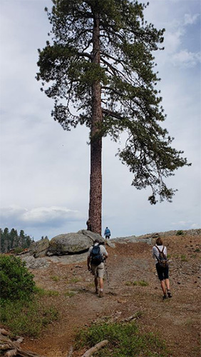
 Trailblazers pose for their Muir Grove Trail group shot. |
 The trail passes through beautiful glades and groves as we follow the contour of the mountain. |
 Look over Gary’s head for the characteristic rounded tops of giant sequoias. |
Muir Grove also becomes visible in the distance. |
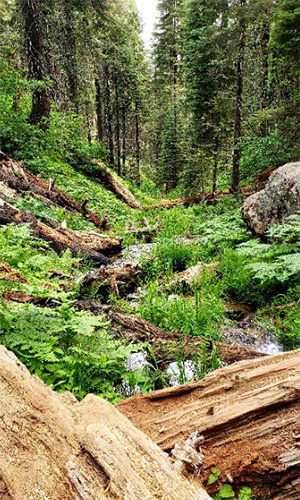
 This stream crossing depends on a bridge made of logs that look every bit of 5,000 years old! |
 The exposure is not all that great, but it is a victory to have crossed twice and still have dry boots |
|
|
| The streambed is rough below the bridge. From there on the path is clear to Muir Grove. | |
 In mid-summer lupines bloom here, contrasting their bright blue against the cinnamon-red sequoia bark. |
|

|
 The maintained trail ends among the sequoias in Muir Grove, named for celebrated naturalist John Muir. |
|
|
|
With one last look up from the center of Muir Grove, the Trailblazers leave with their memories and the peace this special place has brought to our spirits. |
|
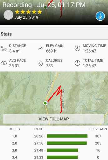
Thursday, July 25, 2019: Little Baldy Trail by Lin |
|
After we hiked Muir Grove trail, six of us still had a bundle of energy and wanted to do more hiking, so we decided to hike the Little Baldy trail. Our hikers were Ann, John B, Chris, Lin, Yanis, and Deirdre. Little Baldy Trail is a 3.3 mile, moderately trafficked, out and back trail located on the General Highway. The summit on this hike offers an amazing view of the Silliman Crest and Great Western Divide. The trailhead is located 1.5 miles south of Dorst Campground. We parked our cars at west side of the General Highway; walked across the highway to our trailhead, took a group picture and hit the trail. |
 Two playful marmots. |
 Chris, Ann, Yanis, John B, Deidre, with Lin taking the picture. |
|
This 3.3-mile trail is known for the wildflowers and wonderful views. Not long into our hike, we encounter two marmots in the middle of trail. They were big and FAT. We stopped try to take some pictures, waiting for those two playful marmots to get out of our way, but they just totally ignored us. They were playing Hide and seek—in this rock, out on other hole—they were on right side of road, then there were on left side of road. They just had a ball playing with each other. Obviously, we were not as strange to them as we think we are. This is their backyard, we had entered their territory, and today it was they play day! Soon, we had all the photos we needed and left them behind to continue our hike. The trail to the top is only 1.7 miles one-way, but it ascends almost 800 feet. After two switchbacks, we were guided into quiet forest. The hills were covered with lush of green and beautiful wildflowers. There are white, yellow and pink. |
 What kind of plant is this? |
 Is this a plant or a flower? |
 White flowers. |
 Bee at work. |
 I am purple, and I am pretty. |
 Yellow wildflowers. |
|
After the forest, we enter a flat area with tall and dense ferns. By then I noticed I was all alone. I know Yanis and Chris were ahead of me, and Ann and John were behind me, I was with Deirdre, but she was nowhere to be seen. This is bear country! Suddenly I got scared. The ferns were so high that I really cannot see anything if bears were hidden there. What would happen if a bear jumped out those ferns? What would happen if the bear comes up behind me? So naturally, I started to cough. While we were at Great Teton National Park last year, we took ranger-led program: How to Protect yourself in Bear Country. Teton and Yellowstone National Parks are designated as bear county. If you want to hike at Teton and Yellowstone National Park, you are required to carry bear spray. At the program, the ranger told us that the bear is afraid of humans, they really do not want to have anything to do with you. So, when you hike on the trail, keep talking, try to make noise, laugh, cough, just let the bear know, you (a human) are coming. Here on this trail today, I remember those words from that ranger. For next few minutes, while I was picking up my speed, I began to cough and say in a loud clear voice “hello, bear.” Soon, my loud fake coughing got Yanis’ and Chris’ attention They stopped ahead of me and asked me if I was okay. I said I was fine, with huge sigh of relief. |
 The trail gets lost in this ocean of flowers. |
|
After I told my fake cough story to Yanis and Chris, the rest of our group caught up. We were at top of an expose granite dome. What a view! The dark clouds hung low. The air was hazy with the smell of burn controlled burns in the forest. It was not a perfect view, but the grand outlines of Silliman Crest and Great Western Divide is there for all to see. |
 The top of Mt. Baldy’s granite dome. |
|
From a distance, we heard the thunder clearly and we could see the dark clouds were moving towards us quickly. We knew we needed to move away from this open dome. But we are Arizona Trailblazers, we need to celebrate, we need to do group JUMP before we leave. Haha! So we did jump. You are the judge, who you think jumped the highest? |
 Let’s try it: 1, 2, 3, jump! |
 Try again: 1, 2, 3, jump! |

|
The return hike to the trailhead is easy because it is all downhill from here. I heard Deirdre said “STOP, I think I see something”. We both stopped and looked to the left about 10 feet away from our spot. There was this little guy. He was smaller than wild turkey, but bigger than chicken. It is a grouse! We were both were so happy because this was the first time we ever saw them in the wild. The grouse shyly walked out the bushes to strike a pose, then he quickly ran cross the trail and disappeared into the wilderness. Ha! that was the bonus for this hike! There were colorful wildflowers, the was the awesome view, and those two fat Marmots, now here is the little follow: grouse! What a great short and fun hike! |
|
From my AllTrails record: |
|
Thursday, July 25, 2019: Crystal Cave Tour by John S. |
|
After several alternative hikes or some down-time Thursday morning, the Arizona Trailblazers rendezvoused at Crystal Cave for our 4:30 PM Discovery Tour. The cave is located at the end of a winding 7-mile road off the Generals Highway near the Giant Forest. We came to see wondrous underground works of marble and water and were not disappointed. We got an in-depth experience of the cave’s geology and learned about the interesting plants and animals living in and around the cave. We met our naturalist guide at the beginning of the trail, hiked down the steep half mile trail to the cave entrance, and after passing through the spider web gate, we spent an hour and a half doing our ecosystem exploration inside the cave. The cave portion of the tour was led by flashlight. Flashlights were provided. We saw beautiful formations, impressively large rooms and ornate marble polished by a subterranean stream. At one point we turned all the lights off so we could experience the eeriness of total “I can’t see my hand in front of my face” darkness. After our tour we had dinner at the Peak Restaurant, the Wuksachi Lodge’s premier dining venue with a focus on fresh, local, sustainable, and organic ingredients. |
 Our tour was the last one for the day. |
 We had to wait until all the people from the previous tours got back to the parking lot. |
 “You see, it’s like this.” |
|
Our naturalist guide was very informative and raised our concerns about the white nose disease, now beginning to threaten extinction for the bats in the Sierra Nevada Mountains. Crystal Cave is an excellent example of a marble cavern. A half mile loop trail leads through the cave, and there’s also a steep half-mile walk to and from the cave parking area to the entrance. Because of fragile formations, the only way to visit the cave is on a guided tour. Our tour guide told us that there are over 200 caves in the park. We also learned about White-nose Syndrome, a fungal disease killing bats in North America. It has had the most impact in the eastern half of the United States and in Canada, killing millions of bats. The disease has now been detected in some caves in California. The trail to the cave follows this stream down the steep inclines of the valley. |
 Gary wore the correct gear to blend in with his surroundings. |
 The stream was quite wild, and the falls were roaring. |
 The cave entrance is also the source of the only cool air in this humid rain forest environment. |
 Group shot at the entrance to Crystal Cave. |
 The notorious Spider Web gate through which we must pass. |
 Great crystal stalactites hang like icicles over the flowing stream below. |
 The curtains are parted. Who goes there? |
 The Grand Pipe Organ formation. |
 The Crystal Waterfall formation. |
 The fleeting shadow of one of the ancient ones passes across the cave wall before us. |
 It was getting dark when we made our way back up the canyon to the parking lot. |
 We felt we deserved an elegant evening meal at the Lodge. |
 It was good food and cool drinks all around. |
|
If we thought the cave was dark, getting out of the lodge parking lot with only starlight to guide us gave a whole new meaning to “stumbling around in the darkness.” Eventually we all made it back to our tents by bedtime. |
|
Friday, July 26, 2019: Sunset at Moro Rock by Lin |
|
Watching the sunset at Moro Rock was on our bucket list. Wayne kept asking, “Lin, are you going to the Moro Rock for Sunset?” In addition, Mimi, Ann, and John had not yet been to Moro Rock. So on Friday, our last evening in Sequoia NP, eight of us decided we would go catch sunset from this monumental vantage point. Our crew were Mohammed, Yanis, Ann, John B, Wayne, Mimi, Lin, and Chris. Sunset is at 8:05 PM. We left campground at 7:10 PM and, after 20 minutes-lish drive, we arrived the Moro Rock parking lot. The parking lot was quite full, so we were not the only group who wanted to see the sunset at this special place. From the parking lot to the top of Moro Rock is 0.6 miles, but it is steep, narrow passage with 400 steps to climb. Time is limited, so we all worked hard and tried to get to the top before sunset. WOW, we arrived at the top just in time to enjoy this perfect moment! |
 Golden light reflected on the puffy clouds. |
 Sunset, hiking boots, and me. |
 Sunset approaches. |
 The color of the sky, is it orange, yellow, or golden? |
 Mimi is enjoying her hike. |
It was very peaceful—colors of Red and Orange covered the sky in the west, layers of mountains in the distance range from light gray to dark brown. The air was hazy, but the cool breeze was refreshing. Some of people were laughing with big smiles on their faces. A few couples were hugging and holding each other close; some of people were sitting on the rock with closed eyes letting the golden light cover them from toe to head. Confess or pray? Some of the photographers might get lost in this moment, but there’s no time to waste if you want to catch the best photo. Others of us just listen sound of our heartbeats and let the warm sunlight dance between our breaths and thoughts. What a view, what a moment! It is sunset at Moro Rock and it is magical! |
 The layers of the mountains stand still. |
 Wayne is setting up his camera for group pictures. |
 Beautiful sunset and smiling faces! |
| John B, Chris, Yanis, Wayne, Lin, Ann, Mimi, Mohammed |
|
Friday, July 26, 2019: Tokopah Falls Hike (2nd time) by Carl L. |
 Tokopah Valley Trail to Tokopah Falls Several of us had done the hike a couple of days before. It is a very pretty hike through the valley. For much of the time the trail is just above, but near, the river. It is just a short hop to various places where you can reach in and touch the very cold water. This is a very gently sloped trail. We do cross a couple of side rivulets, but nothing over two-or-three inches deep. We encounter a bear foraging for food (grub worms, etc.), tearing apart a decaying fallen tree. He is just a cub. The worry, of course, is that the mama bear will be somewhere nearby, and if she felt the cub were threatened, well! Made it up to the waterfalls and got some nice group photos. We then headed back down and encountered a deer. It was a fun hike, just right in terms of length and time. A very contemplative trail, great for just being at one with nature, touching the cold water, encountering wildlife, and marveling at the complexity of the world we live in. Enjoy the photos, and think about the beauty and awe and wonder of things. |
 The river. |
 Rapids. |
 Young bear cub foraging for grub worms. |
 Same bear looking around. |
 Same bear cub running off. |
 The group, enjoying the falls. |
 A relaxed group. |
 Smiling faces. |
 Stairway to Heaven. |
 A deer checks things out. |
 The deer is still checking things out. |
 Downed tree, one day producing food for the bear. |
 Family time at the creek. |
|
Saturday, July 27, 2019: Wuksachi Trail by Jade |
|
On a bright Saturday morning, nine alert hikers and one groggy trip report writer woke up bright and early (7AM) to make what would be the last hike of the camping trip. We drove, after a couple missed communications and stops, to the last parking lot at the end of the road that Wuksachi Lodge resides on, to the Wuksachi Trailhead. The sun hadn’t spilled over the mountain and into the valley yet. The forest was still quiet, not yet ready to awaken and start its day. The morning was cool, crisp, and filled with potential. |
 Ten intrepid hikers in the early morning. |
|
A perfect start to the hike and a perfect end to the trip. The Wuksachi Trail from the Lodge to the Lodgepole Campground is a 3-mile hike that starts on the last parking lot at the end of the road leading to the Wuksachi Lodge. It’s a mostly a downhill hike that takes you over creeks and around hills and under bright morning skies, with plenty of opportunities to enjoy nature and spot wildlife. Now I was told that this was an “all downhill trail straight from the Lodge to the campsite, you should join us, Jade!” by a very certain trip leader. I am here to tell you that this is blatantly untrue, there is a section where you go uphill, and I hold this as a reminder to all to make sure your trip leader isn’t goofing with you to make you get up early to go on a hike. The hike itself was a quiet, empty, and overall extremely beautiful one. We started off from the parking lot heading downhill through trees and forest, with only our nine compatriots, the flora, the misty morning air, and one extremely confused deer to keep us company. It is great fun encountering wildlife on the trails. |
 An inquisitive deer. |
 Who is the more startled? |
 Carl is busy taking a picture of the deer. |
 Walking across an interesting bridge. |
 The bridge doesn’t go straight across. |
 Deer. Where? There! |
 The group (Lin is taking the photo). |
 A happy couple. |
 Lin made us do this! |
 Walking the line. |
 Another “walking the line”. |
 Checking out the fish. |
The trail wound its way down, then up, then down again as we brave hikers battled treacherous terrain, uphill trails, and perilous water monsters. Two well-made bridges suspended over creeks and a couple non-bridged creek crossings, another slightly less confused deer who disappeared into the brush once it saw us, and a severe lack of theatricality a very well-maintained and beautiful trail. The hike ended with sunlight peeking over the mountains, warming the forest below, and a group of hikers marching in order back into the campground, to the surprise of a couple Arizona Trailblazers camping at a nearby site. The Wuksachi Trail is a beautiful trail, with perfect weather and wonderful scenery and fantastic company. I would recommend it to all future Sequoia travelers. Thank you to all the hikers who participated in this hike and provided pictures! |
|
Sunday, July 28, 2019: Barstow to Phoenix by Lin [with a few comments from John S] |
|
Today is last day of our car camping trip. I am sure most people were sleeping in and enjoying the nice, soft comfortable bed. We did. We got up at 7:30 AM and took our time to enjoy our breakfast. Wow, it tasted so good. We left the hotel at various times. Some of us picked the shortest distance, directly back to Phoenix. Some of us did a little detour to check another place. By 8 PM, I’d received almost everyone’s text messages or email informing me they were safely home. WOW, A year-long planning, the nine days of camping trip was official over and successfully done. It was a fun trip. The weather was almost perfect, the scenery was beautiful and breathtaking, the air was cool and almost clean (with some controlled burn smoke), the food was yummy, the song of birds every morning was music in the air. The bear visited almost every night, which was both exciting and scary. The sequoia tree and the Trailblazers for company were AWESOME and AWESOME. So many things we need to be thankful and let me start with my list here and now: [You are welcome to show us your list, Lin. Please allow me to insert a few items into your list, starting with this one: John S.] [Thank you, Lin for undertaking this monumental journey and for shepherding your huge flock hither and yon as we each, in our own way, answered the call of the Mountains.] Thanks to everyone who joined me for this week-long camping trip. Thanks to Mimi, Joe, Ralph. Ken, Deirdre, Gary, Jim, Chuck, John S, Yanis, Rudy, Carl, Mary, who made the reservations for our sites and let us to use their senior passes to save costs. Thanks for the almost perfect weather. Thanks to you, Jim, for taking care of the attendance every day while you were there. Thanks to you, Wayne, for taking a group picture every day and every trail for this trip. Thanks to you, Rudy, for keeping the campfire going every night. Thanks to you, Joe, for marching into the forest to find firewood. I have pictures to show your mighty strength. Thanks to Rudy, John S, and Jade, for your calming songs and your guitars every night at campfire. [Thanks to everyone who sang along with us or encouraged us to continue. Rudy probably is known far and wide for his performances, but Jade and I only play and sing together by camp firelight. John S]. Thanks to everyone for bringing your favorite food and drinks for the potlucks. Thanks to all the potluck helpers (Carol, Jade, Faith, Mimi, Maria, Diva, June, Michelle, Ann, Karen, Nicole, Mary and Karen), the food was so much yummier because you made it all work. Thanks to you Maria, Michelle, and Faith (our new hikers) for joining us on this wonderful trip! Thanks to you, Chuck and Scott, for helping me to lead hikes. You took lots of the pressure off my shoulders (it is a big group after all). Thanks for all the safe drivers, knowing you will bring everyone safely to the campground, the trailheads, and back home on this long driving trip. I am so grateful. Thank you all photographers, too many to name, for your submissions. No, seriously! I lost track of who submitted which photos. Especially with all the hands these documents have passed through. Who’s to say if this General Sherman Tree photo is yours or mine? Thanks to you, Arizona Trailblazers Hiking Club, because we who are all outdoors and nature lovers, are able to share our days, nights, and joys together in this beautiful scenery of Sequoia / Kings Canyon National Parks. Thanks to the people who helped to write this multi-day trip report: Carl, Chuck, Jade, John S, and Scott. A special and big thanks to John S, my friend, my personal editor to read, corrected and edited my not-so-good English report. Very grateful for all your help, John. You are the best. John Muir once said: “The mountains are calling, and I must go.” See you soon, my friends! → Slide Show, by Wayne. |
 Top of Page
Arizona Trailblazers Hiking Club, Phoenix, Arizona
Comments? Send them to the AZHC .
updated November 17, 2019