Outdoor Links
Hike Arizona
Trip Planning Guide
Trip Report Index
Calendar of Events
Library
|
Mt. Wrightson Trip Santa Rita Mountains July 3-5, 2019 by Tamar Gottfried |
|
|
Eight trailblazers started the 4th of July holiday early by meeting south of Tucson in the Green Valley/ Sahurarita area on the 3rd. Most of us enjoyed a delicious meal at Manuel’s, complete with mariachis and margaritas and a tear inducing salsa. We then settled in for an early night. The next day at 5:30 AM, shortly after sunrise, we assembled at the Old Baldy/Super Trailhead and got ready for a long, warm day. The drive on the Old Nogales Highway and then Continental Road into Madera Canyon took 30 minutes from Green Valley, 40 from Sahuarita and was quite pleasant. Two deer ignored us on the slope above the road as they ate their breakfasts. The hike began on the Old Baldy Trail with a 1700 foot climb in 2.3 miles. We had decided to get the shorter, steeper and older trail out of the way first. We were rewarded with shade and breathtaking views of the mine and Green Valley and even Tucson below. |
|
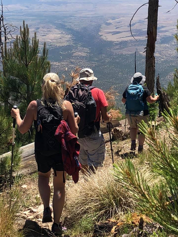
 Up, Up and away! |
|
 Michelle, Mark, Tamar, Bill, Li, Tom, Kelly, Janet We then passed turn offs for the Super Trail as well as a trail to Patagonia (16 miles) and began the steeper and seemingly never-ending climb to the Baldy Saddle. Switchback after switchback awaited us and as we climbed above 8000 ft. Lungs were heaving and heart rates rising. Finally, the saddle was in view and we rested in the brisk winds before making the final 0.9 mile, 1000' push to the summit. |
|
 What a view! [photo by Tom] |
|
|
A more gradual ascent through a fire-damaged hillside awaited us. Although that fire happened in 2005, the trees had not yet recovered from the damage. Soon after, more switchbacks through the rocky area above the tree line started. Finally, we reached the rocky summit, with 360 degree views, even into Mexico. We had snacks, took a few photos, and even found Trailblazer Carolyn, who had started later than us, ran up the longer trail, and was there with a smile and lots of energy to hike down with us. |
|
 Carolyn and Li on the trail. [photo by Tom] |
|
 Trailblazers on the way up. [photo by Tom] |
|
| Janet, Carolyn, Tamar, Kelly, Mark, Michelle, Li | |
 Let’s take a breather. [photo by Tom] |
|
 Made it to the top! [photo by Tom] |
|
 Looks like an observatory up there. [photo by Tom] |
 Let’s go for it. [photo by Tom] |
 Trees grow at an angle on this trail. [photo by Tom] |
 Trailblazers atop Mt. Wrightson. [photo by Li] |
| Li, Tom, Janet, Carolyn, Kelly, Michelle, Mark, Bill, Tamar |
 Heading down from the mountain. [photo by Janet] |
 Finally, a flat stretch of trail! [photo by Janet] |
 Trees march up to the peak. [photo by Janet] |
|
We hiked down almost to the Baldy Saddle and found the unmarked start of the Super Trail. This trail is more gradual, less rocky and spends time on the south face of the mountain. A few hours and 3.7 miles later, we reconvened at the Josephine Saddle. We met some other hikers who thought we were training for something, since our packs were so large. We laughed and explained that we like to be prepared, carrying over 3 litres of water, sufficient snacks and layers for an unexpected night on the mountain, first aid gear, etc. Two hikers veered onto the shorter and steeper route down, wanting to expedite the time to the trailhead. The rest of us masochists, took the longer Super Trail down to complete the figure of 8 loop. Temperatures were now in the 80s and the Super Trail lacks the shade of the Old Baldy. This final 4 miles seemed super long, super tedious and super endless. We were overjoyed to see our cars and shed our boots and find cold beer and soda in our ice chests. As sweaty as we were after 9 hours, 4000 ft of elevation gain and 14.5 miles of hiking, we decided to go back to our hotel/ rental house and shower before getting a meal together. |
 4th of July dinner. [photo by Tom] |
|
The remaining 6 of us relaxed a bit, and then avoided the area of Sahuarita that was preparing for a Fourth of July fireworks celebration by dining at the nearby casino. Food was mostly tasty and satisfying at our early dinner, we saw an Uncle Sam on stilts and then fireworks from our front lawn and none of us had trouble falling asleep that night. The next morning we slept in a little and, although our muscles were achy and tired, decided to have a bit of “hair of the dog” and hike again. We met at 6:45 at the Bog Springs Campground, across from the Santa Rita Lodge in Madera Canyon, a mile before and 400 feet of elevation less than the trailhead of the day before. We easily found the trail across from campsite 13 and began our Bog Springs/ Kent Springs balloon loop hike. After a quick down through a wash, we began our up to the junction of the two trails. We went clockwise onto the Bog Springs Trail with a steady climb up until we reached a small spur trail to Bog Springs. Unlike the springs on Mt. Wrightson, there was actual water here in an oasis of lush trees. We posed for a couple photos and then rejoined the trail for more climbing. We were mostly shaded and a cool breeze welcomed us as we completed the 1600 ft of elevation gain over 2.5 miles After a flatter segment of trail in the trees, we found Kent Spring, which had even more water with a stream flowing down. Here we rested and snacked. |
 Trailblazers at Bog Springs. [photo by Li] |
| Tom, Li, Tamar, Bill, Michelle, Mark |
 Let’s get off to a good start. [photo by Li] |
 We have a fine view from this trail. [photo by Li] |
 This looks like a good place for a break. [photo by Li] |
 Bill and Li enjoy the shade. [photo by Tom] |
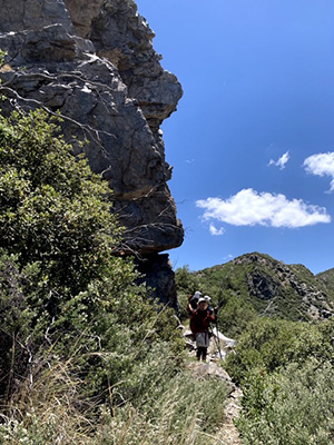 Some of the cliffs have an overhang. [photo by Tom] |
 The woods are lovely, dark and deep. [photo by Li] |
 This trail isn’t bad. [photo by Li] |
|
We found the Kent Spring Trail along the stream and began a steep descent past Sylvester Spring and back to the trail junction. The last mile was warm and rocky and dusty, a change from the greenery of the early morning. After 3 hours and 5 miles, we reached the campground again. From here, Mark and Michelle continued their Southern Arizona adventure, getting ready to explore the Arizona Trail and more, and the rest of us headed for showers, grub, and then back to the valley. It was an exhausting and exhilarating few days of hiking in Madera Canyon and a great way to celebrate the birthday of America. → More Wrightson Summit pictures, by Tom.→ More Bog/Kent Springs pictures, by Tom. → More pictures, by Li. |
 Top of Page
Arizona Trailblazers Hiking Club, Phoenix, Arizona
Comments? Send them to the AZHC .
updated July 8, 2019