
Outdoor Links
Hike Arizona
Trip Planning Guide
Trip Report Index
Calendar of Events
Library
|
Turpentine Loop Day Hike McDowell Sonoran Preserve, Scottsdale February 23, 2020 by Chuck Parsons |
|
 Seven Arizona Trailblazers gather at the Turpentine Trailhead. [photo by Dave] |
| Dave, Alina, Gail, Terry, Vicki, Neil, Chuck |
|
On a chilly (48 degrees) and partly cloudy Sunday morning in late February, seven Arizona Trailblazers gather around the trailhead sign for the Turpentine Trail near the Granite Mountain Trailhead in the McDowell Sonoran Preserve. This is a 7.5-mile loop trail, apparently never before hiked by the Trailblazers according to our vast trip reports and hike descriptions archives. This hike was originally planned for the day before, but due to a very wet weather forecast calling for steady rainfall throughout the morning and possible thunderstorm activity after 11:00 AM, I finally decided to postpone the hike until today which looked to be a much better and drier day for hiking. Unfortunately, as a result we lost a full 2/3 of the group, shrinking in numbers from 21 hikers down to 7. What a difference a single day can make! |
 Gail, Alina, and Dave on the trail. [photo by Terry] |
 Partly cloudy skies begin to form over the desert. [photo by Vicki] |
 Chuparosa are beginning to bloom. [photo by Terry] |
|
At 8:15 AM we strike out on the Turpentine Trail, the first of seven different trails we’ll be hiking today in a large clockwise loop. We’ll finish the loop on the Bootlegger Trail back to the Granite Mountain Trailhead. In between, we’ll be hiking the Whiskey Bottle Trail, the Chuck Wagon Trail, the Balanced Rock Trail, the Granite Mountain Loop Trail, and the Saddlehorn Trail. |
|
|
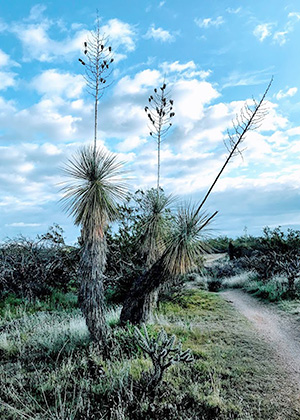
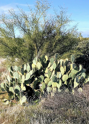
| Yucca and prickly pears grace the trail. [photos by Vicki] | |
 Are we having a good time? [photo by Vicki] |
 Check the map, then let’s go. [photo by Vicki] |
|
Trail dust will definitely not be an issue for hikers today, since the entire trail is soaking wet from yesterday’s heavy rainfall. We encounter muddy sections of trail and even standing pools of water from time to time, but manage to carefully work our way around them. Tramping through heavy mud is never a good practice on relatively fragile desert trails and even worse for off-trail hiking. Not to mention weighing down your boots and pant legs with thick, heavy mud. Definitely not a pleasant experience. |
 Beautiful desert setting in the McDowell Sonoran Preserve. [photo by Vicki] |
 Trailblazers take a short break along the trail. [photo by Vicki] |
|
Even though the weather experts have assured us the previous day’s rain has moved out of most the state by today, from the changing skies overhead you would never know it. As the morning progresses from partly cloudy skies to mostly sunny, with lots of clear blue sky, before we realize it we find ourselves hiking under nearly solid overcast, with dark bands of rain-bearing clouds. Does everyone have raingear with them this morning? From the latest forecast, we certainly didn’t expect to see any rain today. We’ll just have to keep our fingers crossed. |
 Multi-armed giant saguaros reach for the darkening skies. [photo by Terry] |
 We must be getting close to Balanced Rock. [photo by Vicki] |
 Sure enough, here’s the official trail sign. [photo by Vicki] |
 Trailblazers start climbing toward the base of Balanced Rock. [photo by Vicki] |
 Life will find a way. [photo by Vicki] |
|
After two miles of hiking we finally come to the junction with the Whiskey Bottle Trail and from here continue heading west and then northwest in a clockwise loop. Although we begin to warm up under sunny skies, with some of us shedding a layer or two, increasingly overcast conditions keep the temperature hovering in the low 50s. Perhaps a little cool for some hikers, but Terry and I are certainly not complaining. Another 1.3 miles of hiking and we link up with the Chuck Wagon Trail junction. From here we continue in a north and then northeast direction. As we continue hiking the second half of the Turpentine Loop, we begin to encounter increasing numbers of desert wildflowers. Not by any means an Arizona Highways mega-bloom event, but nevertheless more and more color along the trail in the form of California gold poppies, blue lupines, brittlebush, and chuparosa, commonly called the hummingbird bush because of the large numbers of these tiny feathered jewels that are attracted to it. A chuparosa in full bloom, with dozens of hummers darting in and out among its blooms, is quite a sight to behold. After crossing the Powerline Road and hiking for another mile on the Chuck Wagon Trail, we arrive at the junction with the Balanced Rock Trail (at 2,873 feet, the highest point on the loop) and start heading southeast toward Balanced Rock. |
 The precariously balanced Balanced Rock. [photo by Vicki] |
 Gail appears to be supporting Balanced Rock. [photo by Terry] |
 While Vicki is doing her share as well. [photo by Vicki] |
|
After another half mile of hiking, we finally reach the big rock and decide to take a well-deserved rest and snack break here. We work our way up an expanse of granite slickrock and reach the base of Balanced Rock, where we spread out and break out snacks and drinks. Did anyone happen to bring an extra cold beer with them? |
 Trailblazers take a break by the Balanced Rock. [photo by Terry] |
|
This fluffy little bird follows us down to the break site and stays with us the entire time, scurrying and hopping about as it searches for crumbs and morsels tossed its way by hikers taking a break from the trail, including some of us. It shows no fear whatsoever of humans, but will hopefully take flight at the sight of an approaching animal. And, judging from its rather plump appearance, it certainly doesn’t seem to be suffering from any lack of food. The quality of its diet, however, is another matter entirely. |
 This little brown bird keeps up company during lunch. [photo by Terry] |
|
After the break, we rejoin the Balanced Rock Trail and continue hiking for a short distance to the junction with the Granite Mountain Loop Trail. We continue hiking that, in a southeasterly direction for another mile before reaching the Saddlehorn Trail. This short stretch of trail finally links us to the Bootlegger Trail, the last trail in today’s loop hike. A final 0.7 mile push on the Bootlegger Trail returns us back to the Granite Mountain Trailhead. |
 We work our way back down to the main trail. [photo by Vicki] |
 Gail and Alina are on the move. [photo by Vicki] |
 This would not be an ideal location during an earthquake. [photo by Vicki] |
|
We’re all back to our vehicles by 11:30 AM. The temperature remains in the mid-50s, still under solid overcast. Fortunately, not a drop of rain hit us on the trail today. We’ve just completed another brand new loop trail to add to the Arizona Trailblazers’ ever-growing inventory of trails successfully hiked. With that, we decide to call it a day and head our separate ways. This has been yet another great day for hiking Arizona’s Sonoran Desert, or more specifically, the McDowell Sonoran Preserve portion of it. Stats on today’s hike: Total hike mileage 7.3 miles. Total elevation change +-560 feet. → More pictures, by Vicki. |
 Top of Page
Arizona Trailblazers Hiking Club, Phoenix, Arizona
Comments? Send them to the AZHC .
updated March 1, 2020