Outdoor Links
Hike Arizona
Trip Planning Guide
Trip Report Index
Calendar of Events
Library
|
Stewart Pocket Loop Payson June 17, 2022 by Robbi Fowler |
|
|
Five hikers (hike leader—Robbi Fowler, Rodney, Melissa, Donna, Rebecca) met at the cul-de-sac at the end of Phoenix Street in Payson. It was 69° at 6:32 AM when we started out and 89° when we finished. The group hiked 7.6 miles in 4 hours 21 minutes (3 hours 16 minutes moving time – we took lots of social, photo, scenery viewing and hydration stops), +-722' elevation gain. Stewart Pocket is an undeveloped recreation and hiking area in the Tonto National Forest, abutting southeast of the Cypress Boulders Trail in PATS (Payson Area Trail System.) There are two main entrances to the area, the cul-de-sac at the end of East Phoenix Street that runs east of Highway 87 or the entrance off East Granite Dells Road. |
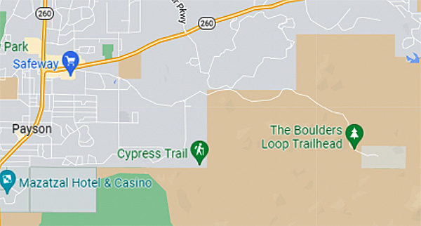 How to get there. |
|
As the name implies, it is a scenic basin (pocket) surrounded by granite towers, boulders, domes and ridges. Average elevation within the pocket is 6,400 feet. It’s substantially forested, and lies within the Tonto National Forest and an elevational belt or biotic community called a life zone. Stewart Pocket is nestled in what is called the Pinyon pine/Juniper Woodland, a life zone existing between 4,000'-7,300' in the state of Arizona. We began our hike from the Cypress Trailhead on E. Phoenix St. in Payson to the Boulders Loop, turned right on South Boulder trail. This portion of the Stewart Pocket Loop is also the Cypress Boulders Hike, which the club has done previously. This was a nicely shaded hike with some sunny sections, and a steady pace of undulating path. |
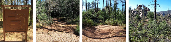 After the sign, we’re out in the woods. [photos by Robbi] |
|
Stewart's Pocket area Pink Rocks may very well rival Sedona’s Red Rocks for their beauty and are much less populated. Flanked by Stewart Ridge on the south and the Mogollon Rim on the north it not only contains the amazing boulder formations of Granite Dells, but numerous peaks or knolls, many topped by pink rocks. Add a mostly year-round stream (Stewart) and various springs, the hiking (and possible camping) is spectacular. This loop goes by car-sized balancing rocks and a truck-size boulder that is almost perfectly round (perhaps they used it in the Indy Jones scene in the tunnel.) If you are so inclined, there are small tangents or alternate social trail routes that cross massive rock faces, circumvent boulder groupings to explore, and dip into washes or stream beds before returning less than 100 yards along the main trail. |
 This is the life! [photos by Robbi] |
 Striped Whip-snake. [photos by Melissa] |
|
We did encounter a snake. One the lead 3 of our group missed and walked most likely right over! Donna, last on the trail, called out “Snake” and I managed to jump as not to step any nearer to it than necessary. Thank goodness it was not a venomous variety. Possibly a striped whip-snake we all convened on the trail to watch it ascend the nearest tree trunk to sniff the air as we took pictures. As planned, we did not continue the Boulders lollipop but turned right in the meadow after gazing in wonder at the huge wash across from Fox Farm. A few hundred feet and lots of Mountain bike banks and tracks later we entered a gentler crossing area of the wash and went directly over to the other side and up the hill beyond. We soon were paralleling a fence separating us from private property, and what gorgeous property it is! Entering the next dell after much ups and downs we left the fence turning southwest into the pocket itself. Every direction was another fascinating rock formation. The trail is well marked, except when you are at a social trail intersection. There are also lots of cairns and ribbons that have long since lost directional help. We stuck to my previous AllTrails tracings and only managed to go a tad off trail once or twice before getting an audible warning from my app. Stewart Pocket Trail has got wonderful marking signs, informing you just how far you have traveled, not on the loop but just the Pocket Trail along the ridge. |
 The trail is well marked. [photos by Robbi] |
|
The ridge is sporadically a shaded hike with some sunny sections, and a good number of ups and downs. It travels through rocky sections, boulders, moonscapes and then pine scented forest pockets with long vistas to the Mogollon Rim, Mountain Peak, Gibson Peak and at times possibly the Hellgate Wilderness. There are lots of rough plank bridges in various states of sun rot. Some still sturdy and some tossed aside to be replaced after disintegration and everything in between. |
 A bridge, and some colorful rock formations. [photos by Melissa] |
|
We took numerous (A) hydration, (B) catch your breath, (C) admire the scenery, or (D) all of the above breaks in the shade of a boulder or clump of trees as the day heated up and the elevation got higher. |
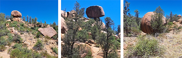 What boulders! [photos by Robbi] |
|
After passing the round boulder, and several intersecting trails (there are two main trail extensions of the Loop that will add mileage and elevation) that we determinedly avoided on this particular day. We turned on Cypress to return the 0.3 miles to the TH. From there the hikers decided on lunch in town at Macky’s Grill and went home.
Getting there: North on AZ-87 - 60.7 miles to Payson When you are parked in the cul-de-sac enter the trailhead by skirting to the left of the concrete water company structure and left of a residential driveway. There’s a small up and down through a usually dry streambed and then a metal walk thru gate and the Cypress Boulder Trail sign. Admission: No fees. |
 Top of Page
Arizona Trailblazers Hiking Club, Phoenix, Arizona
Comments? Send them to the AZHC .
updated June 20, 2022