Outdoor Links
Hike Arizona
Trip Planning Guide
Trip Report Index
Calendar of Events
Library
|
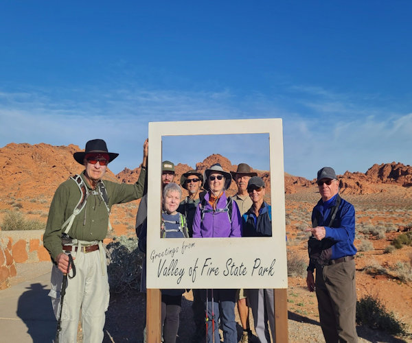
Valley of Fire and Red Rock Canyon Car Camping Trip Valley of Fire, NV Feb 19 – 24, 2023 by Felix Puskaritz |
 Trailblazers in the Valley of Fire. [photo by Lin] |
| Lin, Anna, Keith, Pattie, Ethan, Karen, Felix and William. |
 Rainbow Vista. [photo by Lin] |
| Anna, Karen, Patti, Ethan, Keith, Felix, Lin, William, and Ron. |
Feb 19, 2023 - Arrival at the Valley of Fire:
On Sunday morning, February 19th, three members of the Arizona Trailblazers - Lin, Ron and
Felix met at the Bass Pro parking lot in Mesa to begin the trip north to the Valley of Fire
located about 50 miles northeast of Las Vegas and much closer still to the small town of
Overton, Nevada. Other members including William, Keith, Karen, Ethan, Anna and Patti would
meet us either at the campground that evening or the following morning for the scheduled hikes.
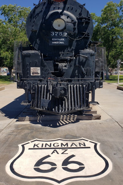 Route 66 in Kingman [photo by Lin] |
Our route began on 202 west connecting with I-10 west until we transitioned to the 303 north and then highway 60 and highway 93 north through Wickenburg and onto Interstate 40 where we then headed west for Kingman and a lunch stop at Mr Dz Route 66 diner. Mr Dzs is a 60s (some might say 50s) theme diner with numerous pictures of cars, Elvis Presley and Marilyn Monroe adorning the walls. The food was good and the staff friendly. Apparently, homemade root beer is considered a special treat. The three of us also took the time to refill our gas tanks in Kingman before making the final drive to the Valley of Fire.
 Enjoy the lunch at Mr. Dz Route 66 Diner. [photo by Lin] |
From interstate 40, we headed north again on highway 93 toward Hoover Dam and then shortly thereafter on highway 169 which parallels somewhat the Old Spanish National Historic Trail on a scenic route along the Lake Mead National Recreation Area. There are numerous scenic opportunities along this drive, but we were anxious to complete our arrival at the Valley of Fire. Arriving at the Valley of Fire State Park, Lin and Felix proceeded to drive to the Atlatl Rock Campground whereas Ron had accommodations at a place in Las Vegas. Driving around the Atlatl Rock Campground, something seemed amiss. There appeared mostly RV's and nothing in the way of large group campsites. Lin stopped and inquired with a ranger and realized that our reservations were at the Beehives Group-Use Campground, just down the road from the junction to the Atlatl Campground. Lin then quickly notified the other trip members.
 Here is our home for next few days (left to Right), our tents - Karen, Felix, Anna, William and Keith. [photo by Lin] |
We proceeded to the Beehives Group Campground to join the other trip participants and make preparations for our evening dinner. There is a bar crossing the road that enters the campground which is intended to ensure that non-campers or daytime visitors are not driving down into the group campsites. However, that did not prevent a number of individuals from crossing over on trails and walking through the Beehives Group Campsites to view the colorful buttes existent in the area. A nearby camper frustrated with the invasion of her campsite inquired as to whether I had a campsite permit and subsequently warned me of the trespassers. The bathrooms at the group campsites were also marked with signs that indicated they were only for use by those with camping reservations. Rangers did arrive a couple of times to check that cars parked at the campsite did have the registration tag hanging from their vehicle rear view mirror and that the fees were properly deposited in the nearby metal receptacles.
 Sun set at our campsite. [photo by Lin] |
William, Keith, Karen, Ethan and Anna subsequently joined Lin and Felix at the Beehives Group Campsite. Introductions were made and after dinner, we proceeded to set up our sleeping accommodations. Everyone would be ensconced comfortably in their tents with the exception of Ethan who was sleeping in his car and Lin who had forgotten her tent poles and also had to sleep in her car. That mishap would prove to be fortuitous a couple evenings later.
 What is the name for our campsite? Beehives? [photo by Lin] |
The sky that evening was to be the most brilliant of the trip completely devoid of any clouds and a stargazers delight. As a result, some in the camp spent some time staring up at the brilliant night sky and commenting on the various constellations. Eventually everyone entered their tent or car, looking forward to the following morning and the hikes in the Valley of Fire.
 It is one of most pretty campsites we ever have. [photo by Lin] |
 Plenty of parking for our vehicles. [photo by Lin] |
 Balenced Rock or mushroom? [photo by Lin] |
 Spring is almost here in this Valley of Fire. [photo by Lin] |
 Stargazing at our campsite. [photo by Lin] |
Feb 20, 2023 -Fire Wave, White Domes Loop, Rainbow Vista and Mouse's Tank
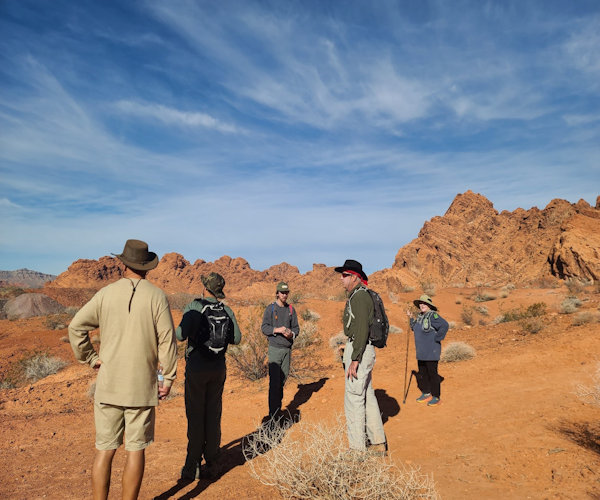
On Monday. February 20th, nine Arizona Trailblazers - Lin, Ron, William, Keith, Karen, Ethan,
Anna, Patti and Felix began hiking the Valley of Fire trails.
 WHY?! we are lost? on the wrong trail? [photo by Ron] |
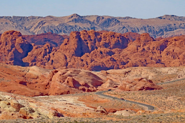
Valley of Fire was first dedicated by locals on Easter Sunday 1934 and although established in
conjunction with three other state parks through concurrent legislation in March 1935, it has
been recognized as the first Nevada state park. During the ensuing years, Valley of Fire became
a popular location for various films and music videos.
 Team of AZTHC is exploring the Five Wave. [photo by Lin] |
Fire Wave and Seven Wonders Loop (Pink Canyon)/White Domes Loop: Our first stop was the parking lot across the road from the Fire Wave Trailhead (which we only became aware after a short hike in the opposite direction). Hiking west and upward, we soon found ourselves overlooking the terminus of the White Domes Road at the White Domes Loop parking area. This overlook together with the park map provided the necessary orientation to identify the Fire Wave Trail as East and across the road from our parking area. Hiking back down and across the road, we began the Fire Wave Trail. The Fire Wave Trail is the most popular hike in the Valley of Fire. The colorful and swirling sandstone waves in Fire Wave have drawn some comparison to the more preeminent and extensive formations found in The Wave located in the Coyote Buttes of the Utah Arizona border. The actual Fire Wave Trail is very short extending only 1.5 miles out and back. However, taking advantage of the numerous photo opportunities, we spent some time marveling at the swirling and colorful formations. We continued hiking past the end of the Fire Wave and on through the Seven Wonders Loop which included the Pink or Patel Canyon.
 Keith, Lin and William are enjoying this hike at Fire Wave. [photo by Felix] |
 Group picture at Top of Fire Wave - Karen, Ron, Patti, Lin, Keith, William, Ethan. [photo by Felix] |
Water in the Pink Canyon caused a temporary detour from the trail that found us hiking south along higher cliffs. We backtracked down to where the Pink Canyon ended near the White Domes Road. Crossing the road, we continued along the Seven Wonders Loop trail that would eventually lead back to the parking area. Somewhere along the trail, we conversed with hikers from the opposite direction and realized it was possible to hike the adjacent White Dome Loop. We continued west through short but unique and narrow passages. Eventually, we arrived at the White Domes parking area where we had lunch before continuing back East on the White Domes Loop. The end of the White Domes Loop began with a descent toward a setting noting the various movies filmed in the Valley of Fire. Hal Roach began filming westerns in the park beginning in the 1920s. Other movies with commercial photo shoots included One Million B.C. (the 1940 version, not the 1966 version), Electric Horseman and Star Trek Generations. The wooden shack at the site was from the Western - The Professionals. The popularity of movie productions in the Valley of Fire was said to be responsible in part for the creation of the park road. We proceeded back on a connecting trail from the White Domes Loop to The Fire Wave/Seven Wonders Loop and headed north back to the parking lot. The White Domes Loop is 1.1 miles and the Fire Wave/Seven Wonders Loop is 1.8 miles. There is minimal mileage connecting the two loops.
 Anna is enjoying the view. [photo by Lin] |
 Anna, Lin, Ethan is waving to William. [photo by William] |
 Ethan, Karen and Lin at Fire Wave. [photo by William] |
 Happy hikers with beautiful smile - Karen, Keith, Patti, and William. [photo by Lin] |
 Pink Canyon with deep water. [photo by Lin] |
 Karen, Keith, William and Lin are having great conversations on the trail. [photo by Ron] |
 Felix is leading a way at Pink Canyon. [photo by Ron] |
 Happy hiker, happy soul and happy feet. [photo by Ron] |
 Pink Canyon and Felix. [photo by Ron] |
After completing the two northern loops, we proceeded back down the White Domes Road and drove out to the end of the Fire Canyon Road for an impressive view. The display at the parking area explained that geological forces were responsible for folding, separating and protracting thousands of feet of surface rock. Subsequent erosion created myriad small canyons.
 Return back to parking lot. [photo by Ron] |
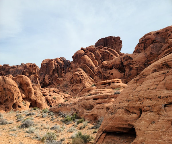
Rainbow Vista:
Our next stop was a 1 mile in and out hike out to the Rainbow Vista viewpoint. Rainbow Vista
gave a view to canyons, domes, ridges and ravines covering 150 million years of time sculpted
from sand deposits that existed in the time of the dinosaurs.
 Overlook of Five Canyon. [photo by Felix] |
Mouse's Tank:
We then drove back to the visitor center to view various exhibits. We discussed whether to hike
the very short Balancing Rock Trail that started at the visitor center. Instead, we decided
wisely to drive back up the White Domes Road and to the Mouse's Tank Trail, a .75 mile out and
back hike. Mouse's Tank was named after a Southern Paiute Indian (Little Mouse), who hid there
from locals who accused Little Mouse of killing two prospectors. Little Mouse was later found
and killed.
|
Overlook of Five Canyon. [photo by Felix] |
The Mouses Tank trail provided an extensive and varied display of petroglyphs, most on the left side of the sandy trail some high above on the black patina. One internet site stated the petroglyphs were arranged in a hierarchy. Water and normal daily activities were depicted closer to the bottom. Higher up were petroglyphs dedicated to hunting with the highest petroglyphs depicting religious rituals. Before the trail ends, the mouse tanks are visible to the left through a narrow gap in the sandstone. The trail itself ended at a massive rockfall.
 Mouses Tank, one of most famous scenery in NV. [photo by Lin] |
However, after climbing up to the left and over, it was possible to descend down to another wash that ended on the other side of the rockfall. Descending into this wash, I encountered a family of four who informed me they had arrived through a different route unknown to most hikers in the Valley of Fire.
 Beginning of at Mouses Tank hike. [photo by Lin] |
 Petroglyphs - Big men holding little people's hand. [photo by Lin] |
 Wall of Petroglyphs. [photo by Lin] |
 A beautiful view of the park. [photo by Ron] |
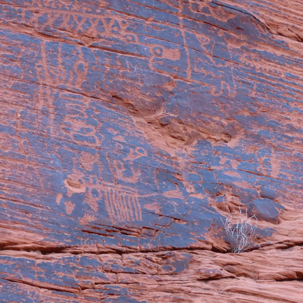 Beautiful Petroglyphs. [photo by Ron] |
 There are so many of Petroglyphs. [photo by Lin] |
 The End of Mouse's Tank trail. [photo by Lin] |
Completing the Mouse's Tanks Trail, we returned to the Beehives Campground and then headed for
showers at the nearby Atlatl Rock Campground. Afterwards two of us climbed the steps to view
the petroglyphs at Atlatl Rock. From there, driving back to our campground, we had the
opportunity to witness Bighorn Sheep up close as they wandered on the various buttes.
Feb 21, 2023 - Elephant Rock Loop and Prospect Trail Hikes
Elephant Rock Loop:
On Tuesday, February 21st, nine Arizona Trailblazers including Lin, Ron, William, Keith, Karen,
Ethan, Anna, Patti and Felix hiked the Elephant Rock Loop in the Valley of Fire State Park.
The Elephant Rock Loop hike including a short scramble up to Elephant rock is approximately
1.5 miles. There is a relatively small parking area just after the East entrance to the park.
 Group picture II - Felix, Ethan, Patti, William, Karen, Keith, Anna and Ron. [photo by Lin] |
Hiking the loop clockwise, you'll arrive shortly at Elephant Rock itself and it remains one of the more famous rock features in the park because of its strong resemblance to an elephant. Signs posted warn hikers to stay off the fragile formation to preserve its presence for future generations. After this short excursion, the trail follows the park road a short distance before circling to the right and into the interior.
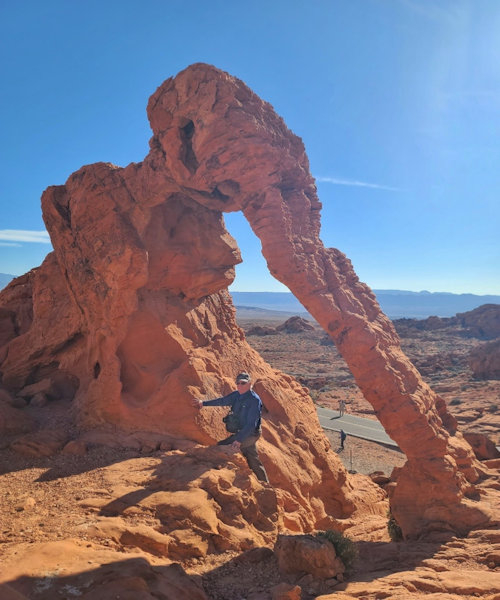 Ron and Elephant Rock. [photo by Lin] |
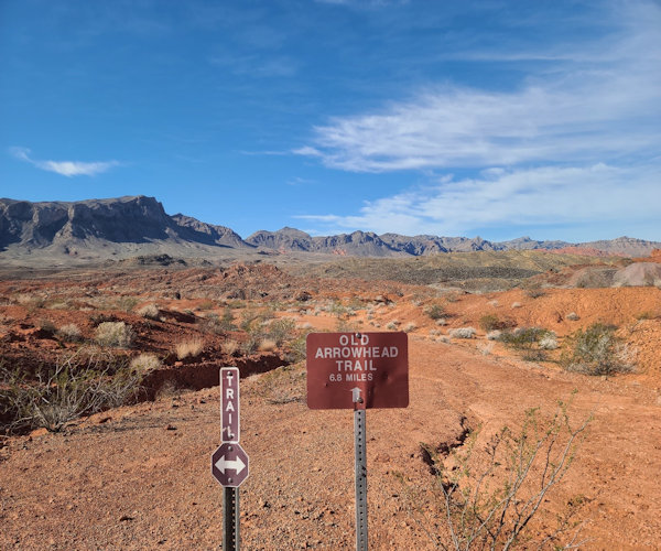
Before leaving the hiking trail adjacent to the road, there is a historical sign referencing the Arrowhead Trail. The Arrowhead Trail or Arrowhead Highway was part of a 1915 era road and the first all-weather road that connected Los Angeles to Salt Lake City. Continuing along the Elephant Rock loop trail, we encountered additional striking rock formations and a stunning contrast of the red rock hills against a deep blue sky.
 Beautiful Rock formation - Elephant Rock. [photo by Ron] |
 Felix is leading the way to hike at Elephant Rock Loop. [photo by Ron] |
 Vacation house? [photo by Ron] |
 A sign of old trail from here. [photo by Lin] |
 Just enjoy the moment, Keith, William, Ethan, Felix and Patti. [photo by Lin] |
 Turtle or Alien? [photo by Lin] |
 Many elephants. [photo by Lin] |
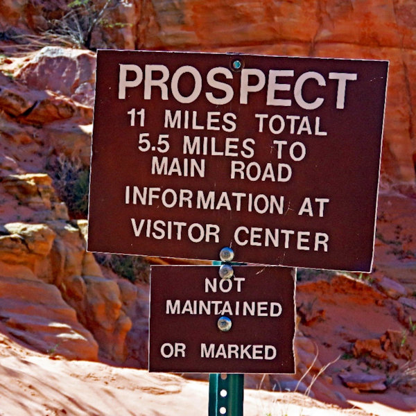
Prospect Trail:
After completing the Elephant Rock Loop, we proceeded on the road back toward the campgrounds.
Just prior to the junction that leads to the Atlatl Campground and before the Petrified Logs Trail,
there is a pullout on the north side of the Valley of Fire Road. This is the southern entrance to
the Prospect Trail. The Prospect Trail runs from this southern terminus all the way up to the
White Domes Loop and is the longest hike in the Valley of Fire. It also includes some of the
most varied geological formations and colors in the park. Along the trail are the red Aztec
sandstone formations along with the white sandstone formations common to the White Domes area.
The sign at the southern terminus references 4.6 miles one way to White Domes whereas the sign near
the White Domes loop at the northern terminus references 5.5 miles back to the main road where our
hike originated. The hike can be done as a car shuttle, but Lin had heard another hiker could not
complete the hike because of a rock fall on the trail so we decided to do an out and back hike.
 Most Challenge trail in Valley of Fire. [photo by Ron] |
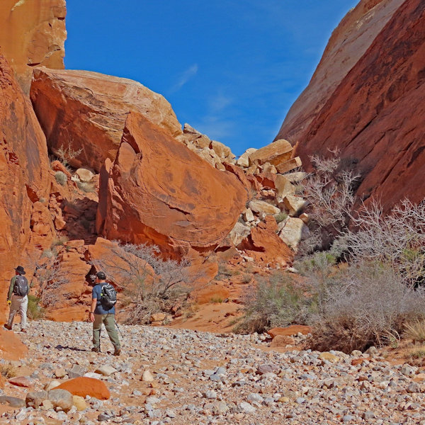
Patti and Karen decided to hike a shorter distance on this trail before turning around and returning back to the Beehives Group Campground. The remaining hikers Lin, Ron, William, Keith, Ethan, Anna and Felix attempted to hike as far as possible before the arrival of a strong wind associated with a winter storm warning. The winds were forecasted to begin approximately at 1 PM.
 A beautiful view on the trail. [photo by Lin] |
The beginning of the Prospect Trail follows a graded dirt road for a short distance until the dirt road turns right. At this point continue hiking straight through an open expanse which rises slightly in elevation as you approach the colorful hills toward the north. The trail is marked in various locations by white poles and eventually descends into a wash. Where the trail descends into the wash, the trail is marked with 3 white poles closely spaced apart directing you to turn downward and sharply to the right into the streambed.
 Prospect trail is this way. [photo by Felix] |
Lin, who had been busy photographing the colorful rock formations and Keith were trailing behind the rest of the group. After a missed turn on the trail, they had fallen behind even more and decided to turn around and head back to the group campground. If you miss this turnoff, you may become temporarily lost but it should not be difficult to retrace your steps and find the trail. The trail follows the wash or gravel streambed for several miles. At one point there are large boulders that appear to block further progress. Perhaps the aforementioned hiker turned around at this point. However, when heading north in the wash, you pivot to the right and up circumventing the large boulders on a fairly well tread trail and then descend back down into the wash.
 Falling Rocks. [photo by Felix] |
As we hiked north toward the White Domes,
there were several side canyons that opened to the right of the wash beckoning us to explore.
However, with the wind warning in mind, we proceeded to hike at a brisk pace hoping to cover as
much ground as possible before turning around. Soon the White Domes came into view, and we
encountered a sole hiker who had hiked south on the Prospect Trail after completing the White Domes
Loop. He had been hiking for about an hour. Factoring his time to complete the White Domes Loop,
completing the entire trail became a strong possibility. Thus, we continued hiking northward.
William who had been tracking the elapse of time, provided an estimate for when to turn around.
However, with the northern terminus of the Prospect Trail looming, we continued to hike past the
turnaround time but perhaps only for 15 or 20 minutes before arriving at the White Domes Loop Trail.
Satisfied to complete the end of the trail, we stopped for 20 to 25 minutes for a lunch break
before hiking south on the Prospect Trail back to the Valley of Fire Road.
As we hiked back south, the sky behind us began turning gray and we realized the winter storm
was quickly moving in. With occasional glances backward and some concern for the eminent
winter storm, we did not stop hiking on the way back until we reached the cars. Along the
way back, we encountered the sole hiker making his way north to the White Domes and another
hiker who was turning around after hiking north from the Valley of Fire Road.
 Felix Stand Still before the wind. [photo by Lin] |
Returning to the Beehives Campground, we discussed whether to stay in camp and weather the storm or seek shelter in nearby hotels. We made the decision to stay in camp which proved to be somewhat daunting later that evening and during the very early morning hours. As the sun was setting, we were treated to a spectacular sunset. The sky appeared to be on fire, a gorgeous contrast to the conical layered sandstone buttes prominent in the Beehives area. After dinner, we made our different preparations for sheltering through the night. Patti and Ron did not camp during the trip. Karen and Ethan left for a stay in a hotel. Lin who had forgot her tent poles slept in her car all three nights. William decided to take down his tent and sleep in his car for the final evening. Keith, Anna and Felix decided to sleep in their tents.
 Sky is on Fire. [photo by Felix] |
Later that evening, the winds came with a vengeance. Blowing so hard, the sides of my tent came
within inches of my face. I watched as the poles of my tent bent and twisted, wondering whether
my tent rain fly would stay in place. I used stronger tent stakes purchased online in lieu of
the cheap stakes that came with my tent. I had also placed large rocks over all the stakes and on
the sides of the tent fly. William and Keith helped Anna re-stake her tent after the sides began
to lift in the strong winds. Keith, whose tent had filled with sand and was sagging badly sought
shelter in Felix's car. During the night and into the early morning hours, the wind continued to
howl. At times, the wind died down but only momentarily. Soon, a whistling sound reverberated
over the patio roof of the dining area signaling that the next powerful gusts were soon arriving.
Those sleeping in the cars noticed a subtle rocking and those in their tents were kept awake through
most of the night by the howling wind and the constant noise from the flapping of the tent fly.
Finally, the wind subsided and those in tents could sleep for a few hours. Taking down my tent
in the morning, I noticed the tent poles had split from the fierce winds. However, I was more
than happy that the morning had finally arrived, and my tent had held during the long night.
We broke camp and headed for Red Rock Canyon, surviving a night we would not soon forget.
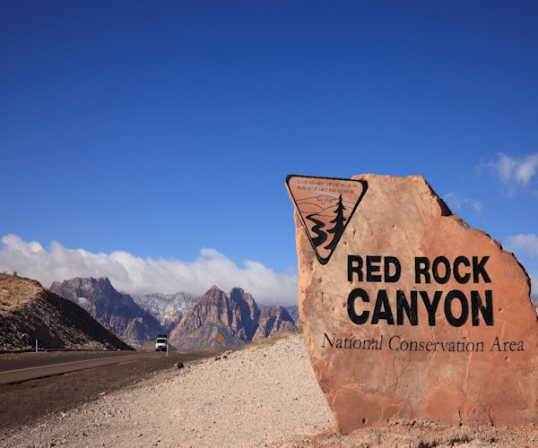
Feb 22, 2023 - Scenic Drive Through Red Rock Canyon
On Wednesday, February 22nd, several Arizona Trailblazers - Lin, Ron, William, Karen, Ethan and
Felix decided to continue the Valley of Fire trip and made our way to Red Rock Canyon. After the
Tuesday night and early Wednesday morning windstorm, it was good to look forward to a couple nights
stay in a hotel room.
 Red Rock Canyon, here we are coming. [photo by Lin] |
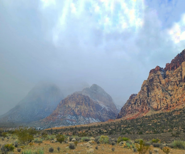
The travel to Red Rock Canyon was uneventful but elsewhere the winter storm would have a significant impact. The Arizona Department of Transportation and the Department of Safety took the rare step of preemptively closing select highways. For a time, I-40 was closed from Gallup, New Mexico all the way to Kingman, AZ. There was snow on the surrounding mountains as we traveled south toward Red Rock Canyon. However, when we arrived the sky above was blue and like Valley of Fire, Red Rock Canyon was also very crowded. Somewhat surprising because of the weather forecast.
 Trailhead to Turtlehead Peak. [photo by Felix] |
The scenic drive through Red Rock Canyon is 13 miles and one way. It opens at 6 AM but closes at different times during the year. The visitor center opens later than the scenic drive. There is an entrance fee but the America the Beautiful Lifetime Pass is accepted. A reservation is also required from Oct - May and available online at recreation.gov.
 William is enjoying the view. [photo by Lin] |
Unlike Valley of Fire, which as a state park is under the jurisdiction of state and local officials, Red Rock Canyon is a national conservation area administered by the BLM encompassing 196,000 acres. Conservation areas are designated by Congress to conserve, protect, enhance and manage public lands for current and future generations. The formation of Red Rock Canyon extends back 540 to 250 million years ago when southern Nevada was part of a tropical sea. The Aztec Sandstone encompassing the colors of red, orange, white and sometimes yellow was the result of geological processes from approximately 200 million years ago. The red color is a result of the iron rich mineral hematite. Red Rock Canyon is famous for the Keystone Thrust, a geologic fracture or fault in the earth's crust where the Pacific plate began to move under the North American plate. As a result, sedimentary limestone and dolomite rock from over 500 million years ago has been thrust above the colorful Aztec Sandstone that was created hundreds of millions of years later. The earliest presence of human habitation in the area extends back to over 9,000 B.C.
 Winter Storm is here. [photo by Lin] |
We gathered together at the visitor center between 10 AM and 11 AM, the time we had reserved online.
It was decided that we would forgo any hiking on this day and instead enjoy the scenic drive while
stopping at the numerous viewpoints throughout the park.
We were not able to car pool together because our cars were crowded from all the camping gear and
supplies necessitated by our stay at Valley of Fire.
Included in the places that I stopped to view were:
Calico Tanks, a wondrous display of multi-colored rock formations.
The trailhead to Turtlehead Peak. The hike up Turtlehead Peak provides one of the most stunning
views of the Red Rock Canyon landscape.
High Point Overlook - a dramatic overview looking south at surrounding terrain and the highest
point on the scenic drive.
Ice Box Canyon - which we had planned to hike the next day.
Red Rock Wash Overlook - providing splendid views looking East of the entire valley.
As the day progressed on the scenic drive, the blue sky gave way to a gray overcast, an
ominous sign of the weather to come.
There were numerous other places to stop but the scenic drive provided a nice overview of the
natural beauty and extensive hiking opportunities available in Red Rock Canyon. After concluding
our scenic drive, we convened back at the visitor center before driving to our respective hotels
for the evening.
 Rain is here. [photo by Lin] |
Feb 23, 2023 Ice Box Canyon
On Thursday, February 23rd, the Arizona Trailblazers remaining from this trip namely Lin, Ron,
William, Karen, Ethan and myself Felix were originally scheduled to arrive at the Red Rock Canyon
Visitor Center between 8 and 9 AM. On Wednesday evening, Lin texted a new meeting time for 9:30.
I did not read the text correctly and arrived slightly before 8 AM. Lin arrived later sometime
after 9 AM with William, Karen and Ethan. With snow falling, we decided to leave the visitor
center shortly before 10:30 to attempt some hikes before the weather turned for the worse.
Lin, Ron and Karen decided not to hike. Prior to that, we spent some time in the visitor
center perusing the various exhibits and discussing potential hikes with a ranger. The ranger
advised against hiking Ice Box Canyon and suggested the Lost Creek Trail to observe a frozen
waterfall, the Petroglyph Wall Trail and the hike out to La Madre Spring. These three trailheads
were all located within a short distance of one another.
William, Karen and Ethan in one car and I in another arrived at the Lost Creek trailhead and
proceeded on the .75-mile hike to the frozen waterfall. Along the way we encountered several
hikers who could not locate the waterfall. After arriving at the waterfall, we were somewhat
disappointed relative to the picture the ranger had shown us earlier at the visitor center.
Perhaps it was too late in the morning because what we did view was a shrub encased in ice and a
rather large gap between the frozen top and frozen bottom of the waterfall. We spent some time
crawling behind the waterfall before leaving for the next hike.
 Waterfall at Ice Box Canyon by Tom Moulin. [photo by Felix] |
I hiked by myself the very short .15-mile Petroglyph Wall Trail and took in a very quick view of
the small panel of petroglyphs. The petroglyphs we viewed on the Mouse's Tank trail in the
Valley of Fire State Park were much more extensive and impressive. However, per the guidebook
referenced below, there are pictographs (painted hands) on the Willow Springs Loop in Red Rock
Canyon. I met William and Ethan and we drove a little farther up the road to the La Madre Spring
trailhead but based on the wind, falling snow and low visibility, we decided against hiking this
trail and instead return to the visitor center. On the one-way scenic drive, Ice Box Canyon is the
next stop after Lost Creek. Although the ranger had recommended against this hike, I could not
resist driving into the parking area. In my mind, Ice Box Canyon would provide at least a sliver
of a hiking experience before leaving for home tomorrow and there was plenty of time left in the day,
winter storm warning or not. William, Ethan and Karen pulled in behind me.
The previous day, I had purchased the Red Rock Canyon Visitor Guide by Tom Moulin. I highly
recommend this book for anyone interested in visiting Red Rock Canyon in the future. The guide
is a great compendium of the hikes, history, flora, fauna, geology and other fascinating
information concerning Red Rock Canyon including beautiful color photos. Unfortunately, I did
not have time to review the guide until several days after returning home.
In the guidebook, Tom identifies a geological process that began 65 million years ago as storm
waters cut through the Aztec Sandstone rock creating the striking Red Rock Canyon that exists today.
Ice Box Canyon is home to bighorn sheep and birds including red-tailed hawks, peregrine falcons,
white-throated swifts and at times, the golden eagle. There was an impressive taxidermy display
of a golden eagle in the visitor center identifying their presence in Red Rock Canyon.
Snow was falling and the wind was blowing but William, Ethan and I decided to start hiking the
trail while Karen stayed behind in the car. Ice Box Canyon is anywhere from a 2.2 mile to a 2.6 mile
in and out hike depending on whether you use the park map or other sources. The first part of the
trail crosses the relatively flat Red Rock Wash before descending to the canyon entrance.
Several hikers in front of us decided to turn around before the very short descent. Hiking up the
canyon consisted of boulder hopping and with snow shrouding the rocky canyon streambed, it added
an additional difficult dimension to the hike. In places, the snow would conceal ice covering
pools of water which inevitably did result in a wet boot. In other places, large boulders needed
to be circumvented to proceed upstream.
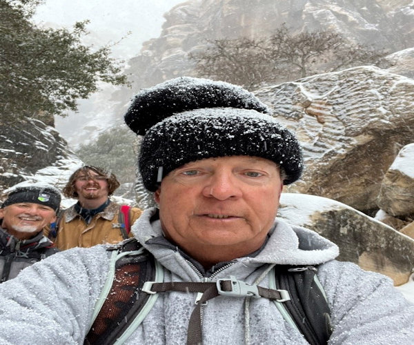 Fearless Leader Felix, and William and Ethan. [photo by Felix] |
The hike up the canyon streambed ends at a waterfall. After hiking up the canyon, we eventually arrived at a place where large boulders hindered any further progress. There was a large plank placed up on one of the boulders that appeared to present a means of climbing up and over but the snow made any attempt ill advised. At this point, I did take several pictures and after reviewing a picture of the waterfall in the guide book, I believe we were very close to the end of the trail. After returning home, I did further research on hiking Ice Box Canyon. One writer identified a Hiking Guy.com You Tube video. The video covers three hikes in Red Rock Canyon - Calico Tanks, Turtlehead Peak and Ice Box Canyon. The narrator in Hiking Guy does identify a higher route at the beginning of the canyon but eventually you descend back into the stream bed. At the 33:29 mark of this video is a tree pressed between two rocks to the left of the plank we had identified. This was the route to reach the very end of Ice Box Canyon. Another video from "That Adventure Life" also describes the route through Ice Box Canyon. Again, the narrator identifies the tree pressed between two rocks as the easiest route to get to the back of the canyon. From there, you work your way across a narrow ledge. There is another slab that will take you up even closer to the waterfall but caution is advised especially if it is raining.
 Time to exit back tp Phoenix. |
Hiking back out was easier since we were able to trace our tracks through the snow.
On the way back out, we heard the voices of two other hikers above the streambed so we scrambled
up higher but were not able to identify any trail. I believe we scrambled up the wrong side of the
canyon. We later encountered the two hikers whose voices we heard while hiking through
Red Rock Wash back to the parking area. They were climbers who based on the weather decided to hike
the canyon instead. In good weather, the canyon is a favorite spot for canyoneering.
Ice Box Canyon derived its name from the cool air descending into the canyon. On a warm day it
provides a welcome respite and a definite contrast to the Calico Tanks area of the park. Although
the name during warmer days may be somewhat of a misnomer, for this hike, it more than lived up to
its name. And that made for a very beautiful and exhilarating experience.
Later that Thursday afternoon, the five of us had an early dinner at the Olive Garden located a
short distance from Red Rock Canyon. All of us were hungry and the all you can eat breadsticks and
soup or salad along with the main course provided a satisfying conclusion to a wintry day.
William generously surprised everyone by paying for the dinner.
The Valley of Fire and Red Rock Canyon trip organized by Lin was scenic, adventurous and eventful.
The winter storm provided an additional element that made the trip even more memorable and one
we would not soon forget.
Feb 24, 2023 - Departure From Red Rock Canyon:
Friday morning, February 24th, the remaining Arizona Trailblazers departed from their various
lodgings and made the journey back to the Valley of the Sun. Several others had already left for
home after our exodus from the Valley of Fire. After checking the road conditions, the best route
back home was the same route taken when we arrived the previous Sunday. There were no issues with
road conditions on this route even in the aftermath of a bad winter storm. Traffic was heavy on
the way to Wickenburg more than likely because of more hazardous conditions on I-40 and I-17 in
and around the Flagstaff area.
Driving separately, we were left to ruminate about our individual memories of the trip.
There was some disappointment that we were not able to hike more trails in Red Rock Canyon,
but the wintry weather did provide a different perspective then what would be encountered during
warmer days. However, we had completed all the trails that we intended to hike in the Valley of Fire.
Hiking Red Rock Canyon would have to be a destination on a future trip.
Thank you to Lin for organizing the trip and to all the Arizona Trailblazers who participated
in this adventure.
Note: these links are temporary. Look at the pictures while you can.
→ More pictures, by Ron.
→ More pictures, by Ron.
→ More pictures, by Ron.
→ More pictures, by Ron.
 Top of Page
Arizona Trailblazers Hiking Club, Phoenix, Arizona updated March 30, 2023
Comments? Send them to the AZHC .