Outdoor Links
Hike Arizona
Trip Planning Guide
Trip Report Index
Calendar of Events
Library
|
North Rim Hike/ Campout Grand Canyon June 15–19, 2025 by Lin Chao |
|
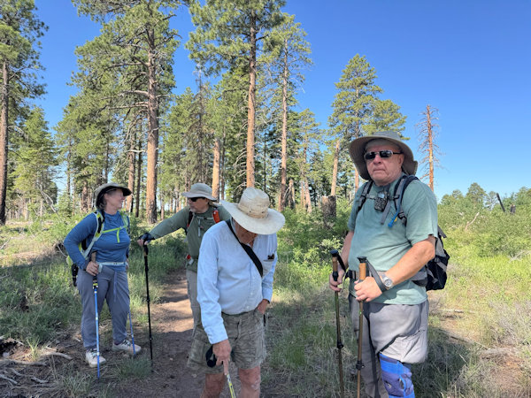
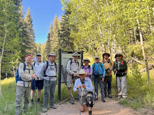 Trailblazers are ready to brave the North Rim. [photo by Robert] |
| Carl, Scott, Kevin, Chris, rudy, anna, Ron, Chuck, Barry. |
• Day 1 - Drive to North Rim (Lin)
This camp out occured before the North Rim fire, so some of these picture are of things no longer there.
Twelve of us from the Arizona Trailblazers Hiking Club embarked on a memorable trip to the North Rim of the Grand Canyon
from June 15 to 19. Although the weather was a bit warm, the cooler temperatures at the rim were a welcome relief after
our long drive from the Valley.
Four of us caravanned from the McDonald's at Carefree Highway and I-17, beginning the journey early in the day. Our first
scenic stop was at Navajo Bridge, where we paused to take photos and scan the cliffs for California Condors—though we didn’t
spot any this time. We continued north and stopped at Jacob Lake for lunch and to fuel up. The food was just okay, but the
break was much needed.
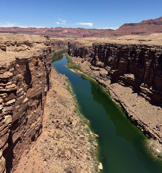 At Navajo Bridge, the Colorado river. |
 Sandwish at Jacob Lake. |
As we approached the park entrance, we were greeted by a stunning sight—herds of bison grazing just beyond the gate. The view was absolutely beautiful and set the tone for the rest of the trip. When we arrived at Group Campsite C, most of our group had already arrived, set up their tents, and were enjoying the cool mountain air. While other are relaxing at campsite, Chuck, Barry, and Kevin, who worked hard to setup their tents and to make sure everyone had a good spot. The group site was impressively spacious, offering plenty of room for all our tents and gear.
 Nap time for those bison. |
 Nap time for those bison. |
It was a great start to an adventure-filled weekend!
 Tents are secured, ready for any wind. |
 Small or large, they are home for the next few days. |
 Prepare dinner? |
• Day 1 - Cape Royal Drive and Sunset at Cape Royal (Carl)
Th Arizona Trailblazers Hiking Club campers at the Grand Canyon North Rim Campground arrived and had camp tents set up –
for the most part – by 2 or 3 PM on Sunday, 15 June. A bunch of us decided to take the drive to Cape Royal for sunset.
We set off about 5 PM from the Group Campsite and drove the 23-mile road – arriving about 6PM and walked around to the
various nearby viewpoints – including Angels Window and the Cape Royal Vistas.
The NPS map shows the drive – Highlighted in yellow is the Campground and Cape Royal
and Angels Window – you can see the road and the various vista points (we did not stop at the vistas – as we would do this
drive with vista stops and short hikes in a couple of days.
 The Cape Royal point. [photo by Chuck] |
 Angel Window. [photo by Scott] |
The sunset period provided for an ever-changing kaleidoscope or Kodak colors – with a light of shades of purple on the Grand Canyon cliffs. After sunset, we drove back to camp and made where a fire was now blazing, and we enjoyed socializing.
 Beautiful color after sunset |
 The colors |
 Rudy play guitar into the night |
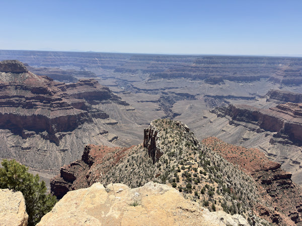
• Day 2—The Widforss Trail (Chuck)
The Widforss Trail is the first scheduled hike on this trip and the longest for some of our hikers. We’ll split into
two groups of five hikers each today. The first group and the fastest hikers will hike the full ten-mile round trip hike
from the trailhead out to Widforss Point and back, while the second group of slower hikers will hike 2.5-miles on the trail
and then turn back, for a total of five miles. With Lin behind the camera lens, nine Arizona Trailblazers, anxious to hit
the trail, gather around the trailhead sign for our first group picture of the trip. It’s almost 7:30 AM on a beautiful
Monday morning in mid-June on the North Rim of the Grand Canyon, as we begin hiking under clear blue skies and a temperature
of about 70 degrees.
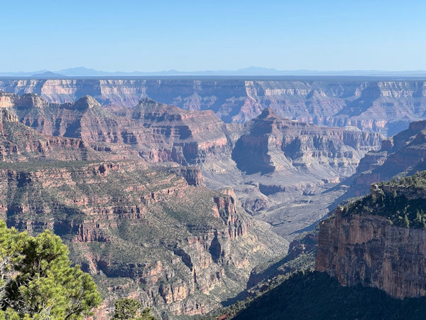
 San Fransico Peaks in the distance, this is Grand Canyon. |
 Uphill from here, Ron and Anna. |
 Happy Ron. [photo by Ron] |
 Walk to the edge of cliff. [photo by Ron] |
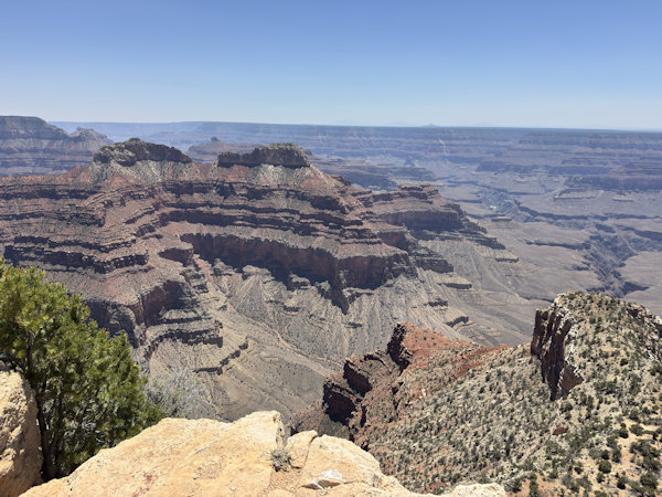
The Widforss Trailhead is located about a mile north of the campground and just beyond the turnoff for the North Kaibab Trailhead on Highway 67. It’s just off Point Sublime Road about a quarter of a mile west of Highway 67. The trail is named after Swedish-born artist Gunnar Widforss, famous for his paintings of numerous national parks including Yosemite, Yellowstone, Bryce, Zion, and Grand Canyon which was his home base from the early 1920s until his death in 1934. The trail begins climbing in earnest shortly beyond the trailhead and continues gaining elevation for the first 3/4 of a mile or more, before gradually leveling off and beginning a long series of gentle ascents and descents. It continues to wind its way through a mixed forest of ponderosa pine, Douglas fir, aspen, and blue spruce in a short series of switchbacks, all the time skirting the rim of Transept Canyon, sometimes referred to simply as The Transept, and offering intermittent and enticing glimpses deep into the canyon along the way, altogether some of the most scenic views on the North Rim.
 Lonely tree. [photo by Ron] |
 It is green and this is our trail. [photo by Ron] |
 Colorful flowers. [photo by Ron] |
Transept Canyon is a major tributary gorge for Bright Angel Canyon, which runs from Roaring Springs Canyon and Roaring Springs
all the way down to the Colorado River, almost 6,000 feet below the North Rim. The Widforss Trail runs for five miles, almost
all the way out to Widforss Point which overlooks Haunted Canyon. Many first-time hikers on the North Rim may mistakenly
believe they’re looking directly into the Grand Canyon at this point, but Transept Canyon is only one of many side canyons
that all form a complex network that drains into the main canyon. There are well over 200 individual tributary canyons carved
and chiseled throughout the primary canyon’s great cliffs and terraces along most of its 277-mile length, all emptying their
runoff into the Colorado River.
Every time we think the trail is finally leveling off, and we’re in for some easy hiking on flat terrain, we’re faced with yet
another long rocky hill to climb or a long stretch of descending trail that we’ll have to climb on the hike back out. Drat!
For some reason, I don’t remember this trail being quite so challenging when we last did it nine years ago in 2016. Could it
possibly be because we’re also nine years older now? Regardless, after 2.5 miles of slow, steady plodding the Ponderous Five
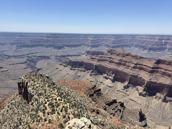
finally reach the head of Transept Canyon and one of the best views on the entire Widforss Trail.
 Beautiful view. |
 At The Widforss Point, Anna, Ron and Kevin. |
We stop to admire the view, take lots of pictures and then take a short rest break before turning around and heading back to
the trailhead. I radio Lin on my TalkAbout to let her know the five of us are heading back. Taking the liberty of borrowing
from my 2016 North Rim trip report when all of us hiked the full ten miles of the Widforss Trail, the trail continues running
along the rim of Transept Canyon for almost another mile, before beginning to veer completely away from the canyon and heading
due south through heavy forest as it heads directly for Widforss Point. But from time to time, we’re still able to walk out
to several additional viewing points for different views into the canyon. After about 3.5 miles though, the trail veers far
away from the rim.
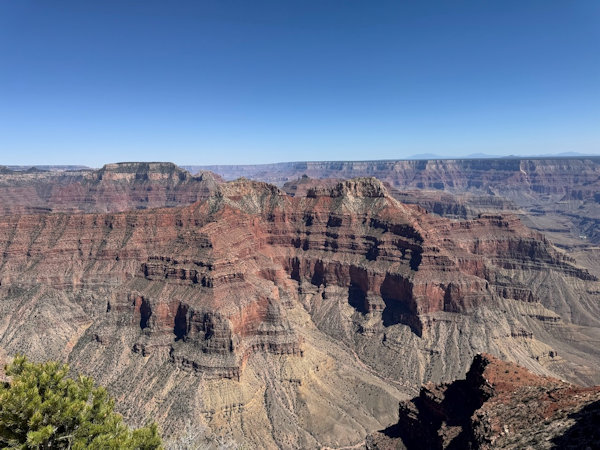
After another mile and a half of hiking under heavy forest cover, the trail finally breaks out into a clearing up ahead,
where most of our hikers are enjoying the view and a lunch break. We can see Widforss Point from here, but the trail doesn’t
actually go there since it’s another 0.5 miles to the southeast as the crow flies. Even though we can’t get to the point
itself, the views from here are absolutely spectacular, looking down into Haunted Canyon and Phantom Creek off in the distance
and taking in sweeping canyon views of Osiris Temple, Isis Temple, Cheops Pyramid, and Buddha Temple. This is truly an Arizona
Highways moment. After lunch, we pack up and start the long five-mile trek back to the trailhead.
 Kevin and Lin are enjoy the view. [photo by Ron] |
 I can see you. [photo by Ron] |
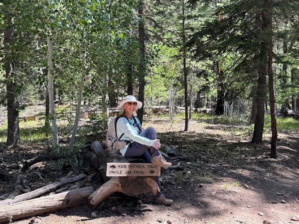
• Day 3—The Uncle Jim Loop Trail. (Chuck)
Lin’s original trip itinerary showed Roaring Springs as today’s primary hike, with the Uncle Jim Loop Trail as an
optional hike for those who didn’t want to do Roaring Springs. But trip itineraries are never set in stone and frequently
subjected to change, usually by the whims of the weather. And this year the unusually warm weather on the North Rim changes
those plans. Instead of daytime highs in the 70s that we normally experience in June, we’re now seeing highs in the mid-80s,
a little too toasty for that 3,050-foot climb from the springs back up to the North Kaibab Trailhead, much of it in full sun.
So, we’ll save Roaring Springs for another hopefully cooler trip, and all eleven of us will be hiking the Uncle Jim Loop Trail
today instead.
 Group picture: Anna, Kevin, Brit, Robyn, Rudy, Ron, Chris, Barry, Chuck. |
 Some small talk. [photo by Robyn] |
Once we reach the trailhead at about 7:30 in several vehicles, we take a quick group picture and split into two groups once again—an advance group of faster hikers and a smaller group of slower hikers. Before long, the faster hikers completely disappear from view, and we won’t see them again until we meet up later on the loop portion of the trail. They start the loop in a counterclockwise direction, while we slower hikers start out clockwise. That wasn’t decided in advance either. It just happened that way.
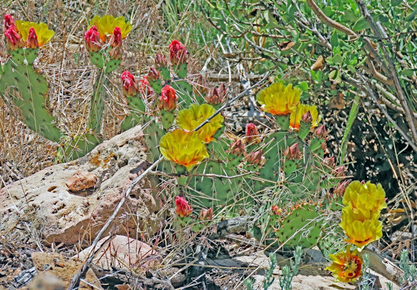
 Beautiful flowers. |
 Full of energy. [photo by Robyn] |
 Happy Mom and daughter. |
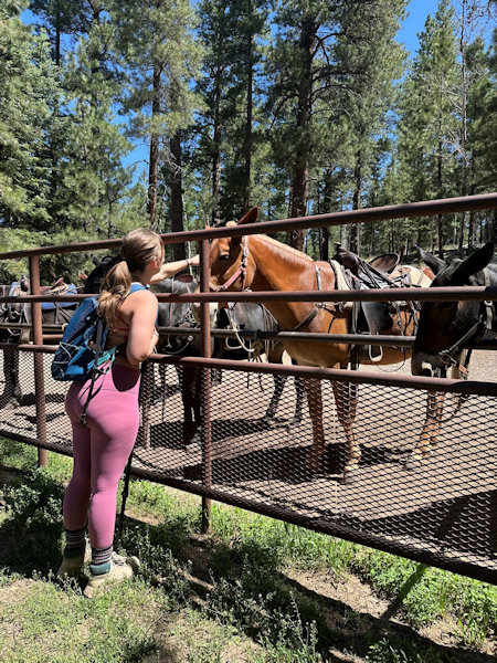
The North Kaibab Trailhead and the Ken Patrick Trailhead both share a common parking lot adjacent to the North Rim Mule Corral, where dozens of mules are patiently waiting to carry riders out to Uncle Jim Point or down the North Kaibab Trail to Supai Tunnel. Today we’ll hike the Ken Patrick Trail northeast for almost a mile, before finally linking up with the Uncle Jim Loop Trail. The Ken Patrick Trail continues in a northeasterly direction for another 9 miles all the way out to Point Imperial, at 8,803 feet in elevation, the highest point on the North Rim. The Uncle Jim Loop Trail was named in honor of James T. “Uncle Jim” Owens who served for 12 years, from 1906 to 1918, as head game warden on the Kaibab Plateau’s Grand Canyon Game Reserve.
 Is it beautiful trail? Kevin, Brit and Robyn. |
 Such a sweet moment - Mother and daughter. |
During that time game management practices called for the complete elimination of predatory species such as wolves and mountain lions, primarily to increase the herd sizes of both deer and elk for the hunters. In this context, game management is actually more of an oxymoron, since “game management” for predators like wolves and mountain lions during that period was simply a euphemism for extermination. Unfortunately, despite everything we’ve learned about these apex predators over the decades and the critical roles they play in maintaining a healthy and diverse ecosystem, that perverse way of thinking still prevails today among a surprising number of people.
 It was a fun day. [photo by Robyn] |
 The team - Robyn, Brit, Anna, Ron, Chris, Kevin. |
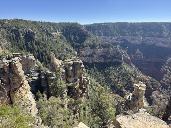
The Ken Patrick Trail winds its way up and down through a thick forest of ponderosa pine, Douglas fir, blue spruce, and
aspen for a quarter-mile or more before we finally catch our first views of Roaring Springs Canyon, a major tributary
canyon of the much larger Bright Angel Canyon that descends all the way down to the Colorado River. After hiking for 0.9 miles,
we finally reached the stem of the Uncle Jim lollipop loop trail. The stem connects the Ken Patrick Trail with the
Uncle Jim Loop Trail itself.
We then hike east on the stem for another half-mile before reaching the actual loop trail, where the views of both canyons
become even more expansive and spectacular. This view of the head of Roaring Springs Canyon clearly shows the steeply
descending multiple switchbacks of the North Kaibab Trail, which drops almost 6,000 vertical feet in 14.2 miles from the
trailhead all the way down to the Colorado River, firmly establishing its reputation as one of the premier hiking trails
in all of Arizona.
 Three Amigos - Barry, Rudy and Chuck. |
 Robyn and Barry are talking, Rudy and Chuck are waiting. |
The Uncle Jim Loop Trail is relatively flat as it skirts the rim of the canyon over much of its course all the way out to
its apex at the southernmost point, with Roaring Springs Canyon to the west and Bright Angel Canyon to the east. The views
are even more spectacular as we continue making our way south, eventually culminating in this magnificent scene from
Uncle Jim Point. From our 8,300-foot vantage point on the edge of the North Rim we are treated to unparalleled views of the
confluence of Roaring Springs Canyon and Bright Angel Canyon, Brahma and Zoroaster temples, the South Rim, and on a clear day
even beyond to the snowcapped San Francisco Peaks, Kendrick Peak, and Bill Williams Mountain just visible on the far horizon.
After finally crossing paths with the faster group of hikers somewhere along the loop trail, we continue hiking in opposite
directions to complete the loop and link back up with the Ken Patrick Trail for the return hike back to the trailhead.
As it usually does, the return hike goes a little faster, and although the faster group is long gone by the time we reach
the trailhead and parking lot, we’re all back safe and sound at the campground in plenty of time for a long, leisurely lunch
and rest break in the shade. And those trail mules? They’re still patiently waiting to carry riders to the Uncle Jim Point or
the Supai Tunnel.
 Stay at Shade when the temperature is warm. |
 Does Chuck say, he cannot find the sign? Well, Anna found it. |
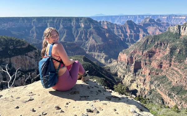
• Day 3—Cape Royal Drive and Viewpoints / Point Imperial Viewpoint (Carl)
The Arizona Trailblazers Hiking Club in the morning hiked the Uncle Jim Trail and, in the afternoon, we did a drive from the
campground to Cape Royal – stopping at a number of Vista points – some of which we did short hikes:
Grassland Lake and Log Cabin – we did a short hike to get to the little “lake” and a little further on was this old
Log Cabin that was used as a Salt Lick Storehouse starting in the 1890s.
Vista Encantada
Roosevelt Point and Trail – we did a short hike along a portion of the trail
Walhalla Overlook – where you can look down at the “Walhalla” Pueblo where Native Americans cultivated crops
alongside the Colorado River
Angels Window – a natural arch/window thru which can be viewed the Colorado river – framed in the window
Cape Royal and Angels Window – where you can do a short walk to walk over the top of Angels Window and look over
the precipice into the vastness of the Grand Canyon – the Colorado River looks to be just a short hop, skip, and jump away!
After spending some time at Angels Window and Cape Royal we jumped back in the cars and made our way over to
Point Imperial – seeing more grand vistas and the vastness of the Grand Canyon and all of the inner canyons within
it – leaving everyone in awe.
 Highlighted in yellow the Campground, Cape Royal, Angels Window and other viewpoints. |
We made our way back to the campground – to the blazing fire and music by Rudy – socializing and enjoying a pleasant evening on the Grand Canyon North Rim.
 Point Imperial. [photo by Scott] |
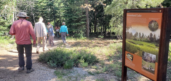 Hike to the Green Land, [photo by Scott] |
 Group picture at AZTH cabin- Chuck, Ron, Barry, Bria, Robyn, Carl, Scott, Chris, Anna. |
 Such sweet moment. |
 The view, the nature, the love. |
 A perfect photo. |
 Jump. |
 The Grand Canyon. |
• Day 4—Point Sublime (Carl)
Wow! Sublime! Wrap-around Vistas! Fun four-wheeling! Ponderosa Pines! Spruce! Douglas Firs! Quaking Aspens! Meadows!
Did I mention Panoramic Vistas! Adventure! Challenge! Fun! Sheer Drop-offs! Sublime Vistas are the payoff!
Those are the words and phrases that come to mind on the adventure- and fun-filled drive and walking around Point Sublime.
The Arizona Trailblazers were last here in 2021 – and the road was very easy and not at all so off-camber, rocky, with big
holes, and miles of deep ruts that sure made having a 4x4 high-clearance vehicle a necessity.
From OnX: This trail is single vehicle width, mild exposure, off-camber, and steep, with lots of sharp rocks, and deep silt
at some spots. Deadfall blocking the trail is common. The Technical rating is 4 (Moderate, 4x4, high clearance).
The Grand Canyon National Park and Forest Service recommend carrying a good tree saw – as there can be deadfall on the trail.
The Arizona Trailblazers adventured to Point Sublime, on Wednesday, 18 June 2025. We had two vehicles: Rudy drove one and
Lin drove the other – both were high-clearance 4x4s. Lin, Carl, and Chris were in a Jeep Grand Cherokee Trailhawk 4x4 and
Rudy, Chuck, Barry and Scott, were in a high-clearance Nissan 4x4 Pickup. I think those in the backseats were “all shook
up” by the end of the day!
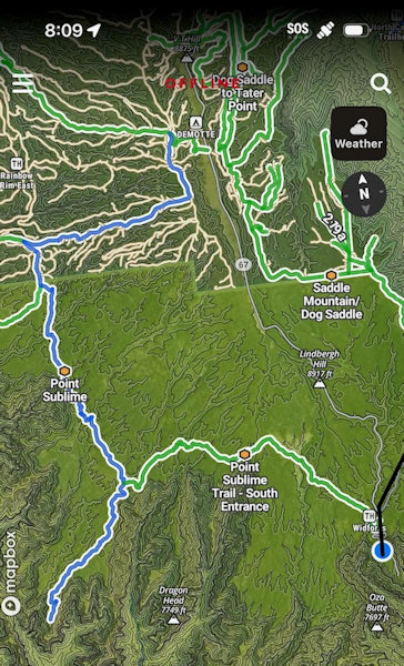
The 3-D map below is from OnX. I have highlighted with a red circle and yellow highlight on the left Point Sublime, and on
the far right, the Widforss Trailhead area which is where the adventure begins.
 3-D map below is from OnX |
I have highlighted in pink the trail to Point Sublime. In, roughly the middle, I have highlighted with a red circle the trail that we took out – going north.
 Map from Benchmark Maps Arizona Road & Recreation Atlas. |
We were lucky in that one of the AZ Trailblazers decided to drive this trail the day before – and he provided us a report –
he went in from the south entrence (Widforss) and drove out though the North FR 22 is where he ended up intersecting highway 67.
So, we decided to go in from FR22. However, while it is easy to find FR22, it is not so easy to figure out – none of the roads
had any discernible trail or road markers or signs – how to get to the road we needed. In the end, we went back to Widforss
trail area and drove to Point Sublime Road from the South. It is clear – as noted above – that this way in requires not only
high clearance but 4x4 and – as the rangers said, you should carry a good tree saw – we saw lots of freshly cut deadfall
(this is all done – it appears – by the users of this trail.
As noted above, there are no adequate superlatives to describe the fun-filled, adventuresome drive and the thrill of seeing the
views at Point Sublime.
 Garmin Map . |
We took the northerly route out, as we got far enough north you could see on the Garmin the mess of trails (we took the highlighted trail which became FR22, and joined (see the highlighted road in the Map snapshot above) SR 67.
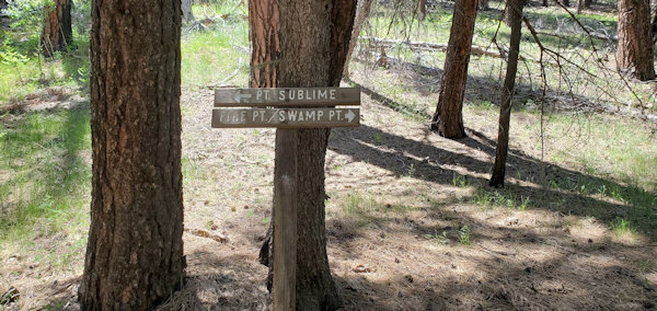 Make left to go to Point Sublime, make right to Fire Point, Swamp pt and Bass North trailhead. [photo by Scott] |
 Point of Sublime. |
 The 360 view of Point of Sublime. |
 Point of sublime. |
 Chuck taking a picture of the beautiful view. |
• Day 3—Point Sublime Adventure (Kevin)
From the North Rim Campground, I took the South road to Point Sublime Trail by Widforss Trailhead. The OnXOffroad
app provides a clear off-road route to Point Sublime. This road is rated between 3 and 4 out of 10 in technical difficulty.
However, there were a couple sections of the trail that were difficult to navigate. But I was able to get through without
incident on the 4-wheel drive SUV. Once at Point Sublime, I met a couple overnight campers who won the lottery to camp at
Point Sublime. They mentioned how amazing it was to watch the storm clouds rolling into the canyon and dumping rain before
dissipating and creating spectacular rainbows. Unfortunately, I didn't see the rain but the view from Point Sublime was
indeed sublime. On the return route, I took Point Sublime road north back to the North Rim entry gate. It was less treacherous
and easier to navigate than the South road.
 Phots from Point Sublime |
 Point Sublime. |
 OnXOffRoad map from Point Sublime Trail, South Entrance to Point Sublime.. |
• Day 4—Kabab Trail, North Rim and Roaring Spring Adventure (Kevin)
Due to the summer heat, I got up at 4:00 am and got on the Kabab Trailhead by 4:35 am.
It was still dark and there were multiple vehicles dropping hikers off for the rim-to-rim hikes. The wind was
blustery and cold such that I wore my portable down vest and light rain jacket for the initial descent. It didn't
take long before it started to heat up and I promptly shed the outer layers. Going down the views from the North Rim
were much better than the South Rim. By the time I got to Roaring Springs, the sun had crested the upper rim and was
starting to heat up. The pit toilets were all boarded up and everything was shut down. Everything has been moved to the
ranger station
about 0.5 mile farther down the trail.
I took a quick break and started
the long trek back up in full sunlight. About 2/3 of the way up I got some nice shade from the soaring cliffs by the trail.
I could feel the combination of physical exertion and heat effect taking a toll on my body. So I took another break and
popped up a couple salt tablets to rehydrate my body. Not long after that I completed the hike and took a break by the
visitor's center and soaked in the views. The 10-mile hike with 3,579' of elevation took 5 hr and 5 min moving time and
5 hr and 40 total time with breaks.
 Starting from the top of Kabab Trail. |
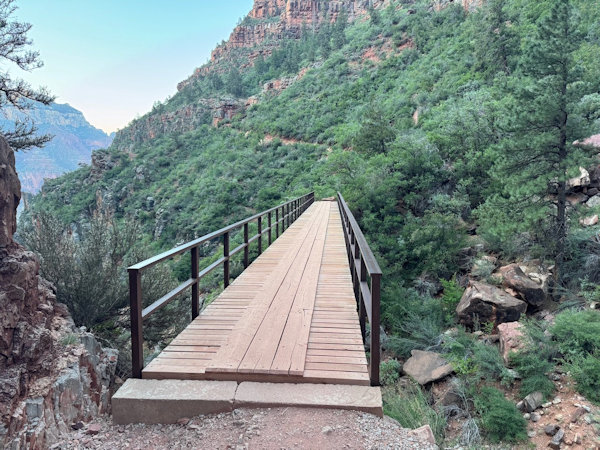 Crossing the Kabab Trail bridge. |
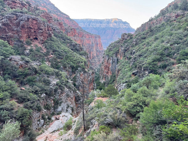 Some amazing views going down Kabab Trail. |
 Some of the cliffs that provided some shade on the return hike. |
 Photo of a Roaring Springs falls just before descending into Roaring Springs rest area |
 Top of Page
Arizona Trailblazers Hiking Club, Phoenix, Arizona updated August 10, 2025
Comments? Send them to the AZHC .