Outdoor Links
Hike Arizona
Trip Planning Guide
Trip Report Index
Calendar of Events
Library
|
Mazatzal Foothills Day Hike Sunflower May 14, 2011 by Bill Zimmermann |
|
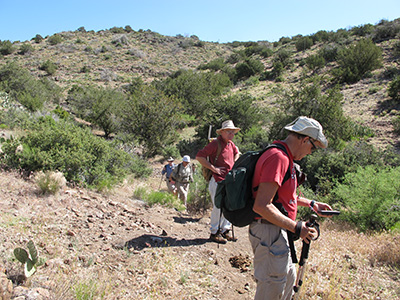
 Trailblazers gather at the gateway to adventure. |
|
Eleven hikers met at Target on Shea in Fountain Hills. After potty and coffee stops at the Shea “K” station we were on our way. We stopped at the Bushnell Tank exit, where Bill left his jeep. Becky and Andy drove us all to the trailhead. We parked the vehicles in the shade next to the creek and started the hike about 8:15. |
 We’re almost to the junction with the Arizona Trail. |
|
The first portion was uphill with a fair amount of cover. We posed for group picture at the first fence crossing ”FX1” At “TX244-344” we picked up the AZ trail and headed south. The trail had small ups and downs with some tree cover. The sight of jack and pinion pine offered a sense of cool. All the small creek crossings were dry. |
 Bill records the latest GPS waypoint. |
 Diamond Mountain dominates the southern skyline from passage 22 of the Arizona Trail. |
 Trailblazers straighten a trail sign that blew down. |
From “FX2” the trail opened up. On the rolling hills we were greeted with gentle breezes. Some of the hikers left the trail to check out a spring. A fence line stopped us short. Ed seemed suggested we stop for lunch break a hilltop with a scenic views. “LB” was the place. However, some of us forfeited the views for shade under juniper tree. |
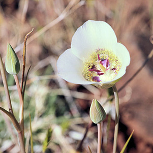 Calochortus ambiguus - Doubting Mariposa Lily |
 Aster frikartii Monch - Frikart’s Aster |
 Eschscholzia mexicana - Mexican Gold Poppy |
 Glandularia bipinnatifida - Dakota Mock Vervain |
 Eriastrum diffusum - Miniature Woollystar |
 Argemone pleiacantha - Southwestern Pricklypoppy |
 We passed through a tunnel under the Beeline Highway. 
|
Two more fence crossings and the “Tunnel” was in sight. After pictures, we crossed under SR87. The trail was now bushy and getting hotter. At “AZT” we left the Arizona trail and headed for the vehicles. The trail to the vehicles soon disappeared as we entered sycamore creek. Tree cover was welcomed. We passed our last fence gate only to later to crawl under the fence on our way to FR22. The hikers enjoyed ice water and cold beer while Bill took Andy and Becky to retrieve their vehicles. Bill’s GPS recorded 7.2 miles, 1050 feet |
| This hike is described in Footloose from Phoenix, by Ted Tenny, pages 85-91. | |
 Top of Page
Comments? Send them to the AZHC .
updated January 6, 2019