Outdoor Links
Hike Arizona
Trip Planning Guide
Trip Report Index
Calendar of Events
Library
|
Bulldog Wash Ridge Goldfield Mountains January 14, 2012 by Ted Tenny |
|
 Monika, Quy, Jim, Lil, Glenn, Jan |
 Blue Ridge glistens in the early morning light.  Volcanic plugs of Bulldog Ridge, from the slope. |
The real treasure of the Goldfield Mountains isn’t what they dug up out of the mines: it’s the fantastic rock formations made by volcanism during the Miocene epoch some 18½ million years ago. Since then, the lava flows and tuff deposits have eroded into intricate shapes which inspire hikers, photographers and naturalists. One of the most scenic regions is inside the triangle formed by Dome Mountain, Peak 3269, and Peak 3134. Getting there involves a major-league bushwhack. It was the destination of our hike. Mark Fogelson reported the Discovery Arch in this area on February 14, 2010, kind of in the middle of the triangle formed by the three peaks. So the Trailblazers set out to find it, carrying Mark’s picture of the arch so we could try to match the background scenery. |
 Trailblazers on the high road to adventure! |
|
Seven savvy Trailblazers start out from Dome Mountain Trailhead northeast of Apache Junction. The morning is sunny, breezy, and decidedly cool, but soon the walking warms us up as climb the Blue Ridge Trail for a bird’s eye view of the Goldfield mining district. The mines are quiet now, but there’s a network of dirt roads including the one that serves as our trail on the top of the ridge. Lithic tuff gives way to basalt at the end of the road. Our trail continues along the ridge to a saddle, then turns northeast and drops down to Triple Trail Junction, where we meet the Orohai Trail and turn northwest. |
 Glenn, Jim, Monika, Ted, Lil, Quy [photo by Jan] Instead of walking the road we go off trail, northwest across the gentle foothills of the southern Goldfields. Horses have been on these slopes, and many deer. After crossing several washes we see an unmarked dirt road going north. The road gives us a distant view of the Echo Arch and then the Trumpet Arch, as we wind our way around a hill and up to the approach of Peak 3134. The route, which Roger Warren helped Ted scout in 2003, is now marked with a cairn. The road ends. A steep, gravely trail takes us down toward a brush-strewn wash. Let the bushwhacking begin! |
 Fantastic formations of Tertiary rhyolite and tuff grace the Goldfields. |
|
We aren’t anywhere close to matching the scenery in Mark’s picture, but neither are we close to the middle of the triangle formed by the three peaks. Onward and upward. Ted is pretty sure the arch is on the east side of a major wash flowing down from Dome Mountain, so we keep to the right of the wash as we make our way northwest around buttes and across the rocks. Monika looks at the picture Mark took through the arch, and she identifies two boulders the slopes of Peak 3269 and a rock ledge. But the arch is clearly above the ledge, and we’re too low. Onward and upward. We’ve got to be getting close, because the scenery is almost lined up with the picture. By this time our group has scattered, with some staying low and others going high, but all within hearing range. Then we find the arch! |
| Discovery Arch: | |
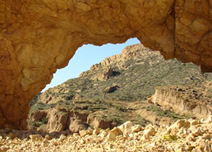 Mark Fogelson, February 14, 2010 |
 Ted and Monika find the arch. [by Lil] |
 Lil Cross, January 14, 2012 |
 Ted Tenny, January 14, 2012 |
 Jan Irvin, January 14, 2012 |
 Jan Irvin, January 14, 2012 |
|
This is a great place for a picnic, though the rock benches aren’t as comfortable as we wish for. As everyone is taking pictures and enjoying lunch, it becomes evident that one of the hikers isn’t with us and is nowhere in sight. No panic, yet. Both Ted and Quy blow whistles. Soon all seven of us are together again. “All of the washes flow into Bulldog Canyon,” Ted advises us as we start back down. It’s a steep, rocky, gravely descent which finally eases up only to become choked with catclaw. After fighting our way through boulders and prickly Sonoran vegetation we climb out of the major wash and head diagonally southeast around a hill. We can’t see the road. “The road is right behind you,” Ted assures Glenn. And so it is. |
 Nodding saguaro overlooks Bulldog Gunsight Pass.  Superstitions catch filtered sunlight beyond Blue Ridge. |
|
Tired feet persuade a majority of the hikers to skip Bulldog Wash Ridge and just walk back on the road. So everyone goes that way. We found the Discovery Arch, enjoying glorious sunshine on the way up with cool, refreshing clouds on the way back. More congenial hiking companions couldn’t exist. Thank you all for going with me! Ted |
|
| → More pictures and commentary, by Jim Buyens. | |
 Top of Page
Arizona Trailblazers Hiking Club, Phoenix, Arizona
Comments? Send them to the AZHC .
updated April 29, 2018