Outdoor Links
Hike Arizona
Trip Planning Guide
Trip Report Index
Calendar of Events
Library
|
Goldfield Oven Day Hike Tonto National Forest December 1, 2012 by Ted Tenny |
|
 Bruce, Gabrielle, Eileen, Don, Quy, Arturo, Rudy, Linda, George, Laurie, Lori [photo by Ted] |
|
A dozen daring Trailblazers set out from Blue Point Recreation Area on an exploratory hike to find the Goldfield Oven and enjoy the Stewart Mountain and Salt River scenery. |
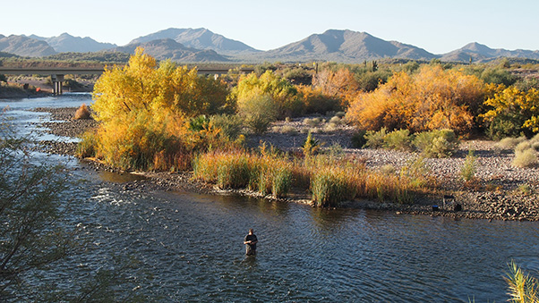 Fisherman tries his luck in the Salt River. [photo by Quy] |
 There! Rudy and Arturo spot some fish. [photo by Quy] |
|
After leaving the recreation area on the north side, the trail hugs the base of the Blue Point cliffs with several ups and downs over rockslides. The morning air is cool so we walk briskly, enjoying the autumn colors along the river. The trail dips down into an unnamed wash which will be our route for the next 2 1/2 miles. The wash is full of sand, firm in a few places but mostly loose. Our leader has never been here before, but has read and re-read an online description of this hike. The first landmark – a big saguaro with many arms – is right where it’s supposed to be. But where are those ovens? Both Bruce and Ted are carefully watching on the right side of the wash as the second landmark comes into view, golden cliffs on the left. Onward and upward, although the entire climb is very gradual. |
 Now that is some saguaro. [photo by Eileen] |

|
|
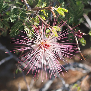
| Chuparosa and Fairy Duster brighten our path. [photos by Quy] | |

|

|
| The Goldfield Oven, from below and above. [photos by Ted] | |
|
Then we see one Goldfield Oven. It’s on the right side of the wash, close by, obviously intended to get something very hot. But why was it built here? This wash is part of the Heber-Reno Sheep Driveway, where sheep were driven up north to their summer pastures. But none of us can figure out why an oven would be needed on the Heber-Reno Sheep Driveway. The wash has taken us generally north. Stewart Mountain briefly comes into view, then disappears again behind some dense vegetation. The streambed is sandy all the way up, sometimes wide, sometimes narrow. The write-up says to stay in the main wash, but there are places where more than one wash looks like it could be the main one. |
 Trailblazers’ inspection of the Goldfield Oven. |

We can see Stewart Mountain. Which way from here? [Ted]
But what we get instead is a very gradual drift to the east, with a lot of turns. The changing appearance of Stewart Mountain on the left and other buttes on the right gives us some sense of progress. In several places it looks like we can leave the wash to get better footing, but then catclaw and other prickly vegetation send us back into the wash. Finally there’s a trail. The trail is completely unmarked, but it leaves the wash on the right side. Bruce puts up a cairn. This trail soon dead-ends at another trail. Here we turn right again, to a ridgeline with panoramic views in every direction. We find a good lunch spot on the ridge. |
 Four Peaks and Saguaro Lake from the ridge. [photo by Quy] |
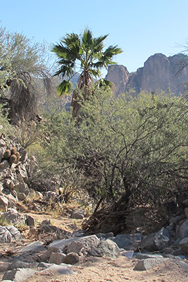 Palm tree in Horsethief Wash. [Ted] |
The trail winds around from one side of the ridge to the other, giving us views of Four Peaks and Saguaro Lake on the left, the McDowell Mountains and Fountain Hills in the distance on the right. Nearby on the right are hills covered with granite boulders, with Teddy Bear chollas and other desert plants growing on their slopes. Granite gives mountains a smoother appearance, since it doesn’t have a preferred direction for breaking. So when you see a mountain with sharp, jagged edges, you can be sure it’s made of other minerals. When the trail finishes its descent into Horsethief Wash we have more sand to walk through. The wash itself has quite a variety of rocks and vegetation, including an unexpected palm tree. It ends after two large drainpipes which carry flood waters underneath the Bush Highway. |

|

|
| Trailblazers enter the dark tunnels, then emerge victorious. [photos by Eileen] | |
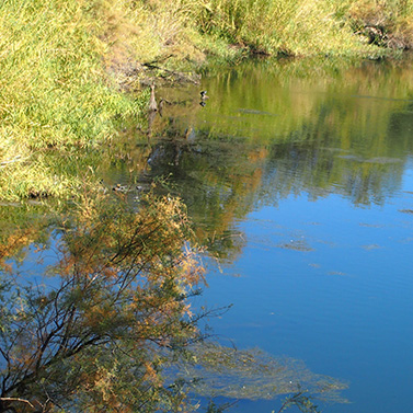
The Salt River is a wildlife sanctuary. [photo by Quy]
A climb on the old highway gets us up to the Salt River Tubing area, and then Water Users’ Trailhead, both of which have been closed for the season [hike leaders, take notice]. But we can walk out to the railing and enjoy colorful views of the autumn leaves and wildlife along the river. Ted points out the Sunrise Arch, halfway up in the Goldfield Mountains on the other side of the river. The arch is visible from this side, but usually overlooked because you can’t see the sky through it from this direction. A trail goes up to the arch, rather steeply. |
 Wild horses take a drink from the river. [photo by Ted] |
|
A gap in the fence at the west end of the parking lot shows us where to cross the highway and pick up a trail on the north side. Three hikers choose to walk the highway back to their cars, while the rest of us walk westward on the trail which parallels the highway. It’s a fairly distinct trail in some places, but hard to find in others. Finally we see the Blue Point Bridge ahead. The trail enters a scrub forest, and we soon arrive back the the Blue Point Recreation Area. This hike is described in Footloose from Phoenix, by Ted Tenny, pages 109-115. |
 Top of Page
Comments? Send them to the AZHC .
updated November 13, 2019