Outdoor Links
Hike Arizona
Trip Planning Guide
Trip Report Index
Calendar of Events
Library
|
Gardner Canyon Day Hike Santa Rita Mountains December 21-22, 2013 by Scott Green |
|
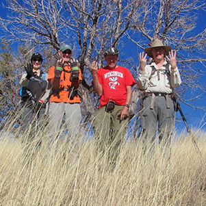
 On top of the world [almost]: Scott, Tom, Bill, Lil. |
|
As Dr Seuss might have said, “This was that and that was this.” Or for this past weekend, Saturday was Sunday and Sunday was Saturday. |
 Those ominous clouds won’t dampen our spirits. The hike was a combo-club hike with the Trailblazers and AzOTC on Saturday completing AZT Passage #5 from Gardner Canyon to FR4072 leading us to highway AZ 83. Sunday was to be a non-club hike also along the AZT further north on Passage #8. |
 Better plan our route carefully this time. |
 ... but the trailhead looks awfully wet to me. |
|
Anticipating what we might find on Passage #5, like snow, it was an easy decision Saturday morning to postpone the Saturday hike one day and tackle the lower elevation hike first. After leaving from the East Valley through Florence, Coolidge, Picacho Peak and then east of Tucson, we headed to a spot just north/east of I-10 and AZ 83. Passage #8 begins at Gabe Zimmerman TH going north to La Posta Quemada Ranch and Colossal Cave Mountain Park. We completed about three-fourths, 11 miles, to Pistol Hill Road. During a future club hike, the passage can be completed with a four mile in/out from Pistol Hill Road to Hope Camp and back. |
 No tussle with this trestle. |
 Ranch country of southern Arizona. |
 Sure, passage 8 has its ups and downs. |
|
Sunday morning while driving to the trailhead and gaining elevation, we eagerly awaited our scheduled Saturday hike. At least we were eager until we noticed the external temperature dropping into the high 20s. As we rode along highway AZ83 and then onto a low-clearance dirt road, we were hoping the day would be different than the day before, of clouds and cold wind. As we exited the truck, we were greeted with ice cold air but without any wind and plenty of sunshine! After a brisk uphill climb, we were toasty for the remainder of the day. |
 Scott, Bill, Tom and Lil celebrate a perfect day for a wintery hike! |
 The Santa Rita Mountains are dusted with snow. |
 This portion of the Arizona Trail is a two-track. |
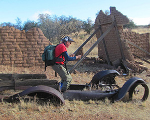
 Bill finds an antique wooden pitchfork on the trail. Once to the top of the first of many soon-to-arrive ridges and hills, we came across an old 8 inch iron pipe constructed with circular bent sheets of metal connected by rivets. Nearby was an interpretive sign explaining that the pipe was a remnant of when mining was very active in the area. The water originated ~10 miles away looping over hills and through ravens on its way toward Kentucky Camp. While mostly underground, the pipe rose near the surface due to hard granite and the impossibility of placing the pipe deeper. |
|
Some 3.7 miles into the hike we entered Kentucky Camp. A very interesting article about the camp is available here: http://kentuckycamp.org/. |
 Kentucky Camp began as a mining camp, built in 1904. |
 Some of their mining equipment is still here. |
 Ride ’em, Bill! |
|
Fortunately the common buildings were open so we were able to peer around and gain an appreciation for what efforts took place in the surrounding area. From there we passed through the main gate, removed the last of our extra layers of clothes and trekked on into the pattern of tall hills and valleys. The grass in this area was impressive due to its height averaging between just above a below our waists. After leaving a saddle we traversed down and found an abandoned mine complete with an old, tall corrugated metal sided building and its own diagonal shaft reaching into the hillside as far as we could see. Not much remained since we were now following a 4X4 road which allowed others to visit the site at will. |
 Onward and upward. |
 Leave each livestock gate as you found it. |
After a few more “over hill, over dale“ experiences, we crossed a road near Wisconsin Mine. Usually this wouldn’t be a big event but with Bill Z. joining us, it was the highlight of the day, at least for Bill wearing his traditional Wisconsin t-shirt. We temporarily left the AZT and traversed along a black tube which lead us to a large elevated water tank like you would see at a construction site for water trucks. According to Bill’s GPS we were close, within a quarter mile, but even after a little cross country/wash bushwhacking, it wasn’t to be seen and any further investigation would require a uphill climb. |
|
With disappointment, we retreated back to the AZT and continued on. |
|
 This part of the trail is well marked. |
 We top out, at last. |
 Scott walks by a candelabra on the trail. |
 The AZT sign needs propping up. |
|
Following on, we passed a 5 foot tall, square, rock and mortar containment room. Those who peered into its depths reported fanciful tales to those who choose not to risk lowering their delicate body through the horizontal strands of barbwire. |
 Better look this one over, Tom. |

|

|
| Cholla and tall grasses characterize the plant community. | |
 We approach our journey’s end — and it’s still daylight. |
|
Eventually we came upon more cattle watering devices and equipment and our passage destination FR4072. From there it was a short 0.8 miles to the road where a previously left vehicle awaited. Wait, you ask, what was the trail’s elevation peak? It was 5,837 feet. Photos by Bill Zimmermann. |
 Top of Page
Arizona Trailblazers Hiking Club, Phoenix, Arizona
Comments? Send them to the AZHC .
updated March 22, 2020