Outdoor Links
Hike Arizona
Trip Planning Guide
Trip Report Index
Calendar of Events
Library
|
North Wilson Mountain Day Hike Sedona April 6, 2013 by Chuck Parsons |
|
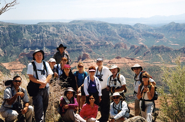
 With Dave behind the lens, 15 Trailblazers gather around the North Wilson Mountain trailhead sign. |
||||
|
||||
|
Under clear blue skies with a cool temperature of 68 degrees, 16 Arizona Trailblazers gather at the north end of the Encinoso Picnic Area on the west side of Highway 89A in Oak Creek Canyon. The trailhead for Wilson Mountain North Trail # 123 is located just beyond here. This is shaping up to be a perfect day for hiking the spectacular Red Rock Country around Sedona. Since this is one of the most scenic hikes in the area, with terrific overlooks at and near the top of Wilson Mountain, it’s hard for me to believe that the last posted trip report for this hike was over ten years ago in November, 2002. Needless to say, we won’t wait another ten years to do this hike again. |
 Stark reminders of the 2006 Brins Fire. [photos by Chuck]  A few green and healthy pine trees stand amid a charred landscape. |
Just minutes from the trailhead we come across this scene of destruction. Hundreds of blackened and sun-bleached tree trunks, some still standing but many long since fallen, are sobering reminders of the devastating Brins Fire that swept through here in the summer of 2006. A campfire left unattended by careless campers quickly got out of control in windy conditions, starting a conflagration that raced across the top of Brins Mesa and then up the south slope of Wilson Mountain all the way to the peak, leaving a charred wasteland in its wake and torching thousands of trees and almost 5,000 acres of prime timber before it was all over eleven days later. It was stopped just short of Slide Rock State Park on its northern boundary and thankfully held in check on the west side of Oak Creek. |
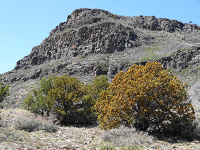
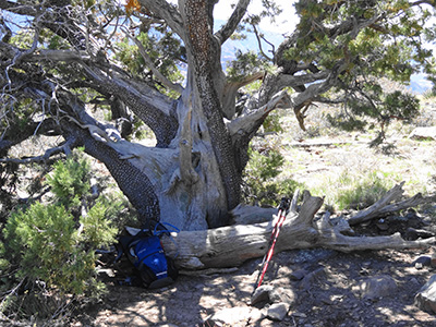 This huge old juniper appears to be holding its own. [photo by Dave] Although we do see some burned out junipers, most are still living and appear to be healthy like this gnarled old juniper which has managed to survive many fires over its two centuries or more of living on this mountain. Scattered pine trees survived the Brins Fire as well and continue to thrive on Wilson Mountain, although the vast majority were incinerated in the 2006 inferno. We will continue to see evidence of this fire all the way to the top of Wilson Mountain and out to the overlooks. |
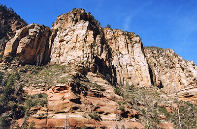 Towering cliffs of Coconino sandstone stand guard over the trail. [photo by Chuck] |
Contrary to the trail information I got from my Sedona Hikes guidebook, the North Wilson Trail starts climbing immediately out of the starting gate, gaining over 1,500 feet of elevation in the first mile or so as it relentlessly switchbacks up the steep northeast slope of Wilson Mountain in search of the summit. If one thing can be said of the Wilson Mountain North Trail, to describe it as a terrific cardio workout would do it justice. |
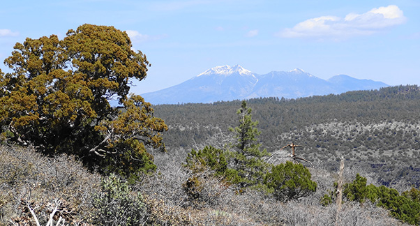 The snow-capped San Francisco Peaks rise in the distance. [photo by Dave] |
|
Less than a mile from the trailhead we’re treated to broad vistas taking in great views of the majestic and snow-covered San Francisco Peaks, rising from their base in the vast Colorado Plateau to over 12,000 feet as they pierce the blue skies over Arizona. This scene also provides an excellent example of timeliness when it comes to photography because any given scene can change dramatically in just a matter of minutes, yes even a mighty mountain range that’s been sitting in the same location for millennia. I was planning on shooting this exact same scene that Dave did in this picture, but foolishly decided to wait until I reached the overlook at the top of the mountain, knowing the view there would be even better. Unfortunately, by the time we finally reached the overview on top of Wilson, the blue skies behind the mountain which provided great contrast for the snow-capped peaks had changed to a milky white and the peaks were virtually obscured in a sea of white. Lesson learned: take the picture right away even if it isn’t optimal so you at least have something to show for your efforts. |
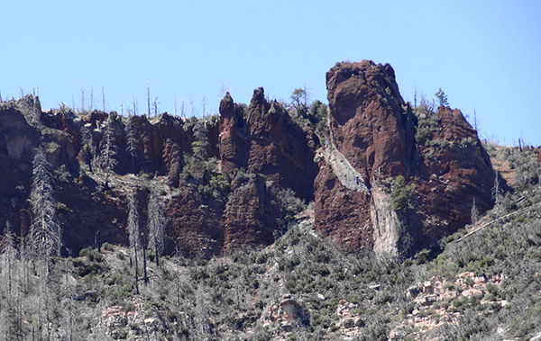 Interesting rock formations loom over the trail as we approach First Bench. [photo by Dave] |
|
This colorful basalt formation comes into view a mile or so into the trail as we continue to make our way up the increasingly steeper switchbacks in quest of the summit. There are so many interesting sights and photo opportunities along the Wilson Mountain North Trail that it’s easy to get distracted by the scenery and forget to concentrate on your hiking and watch where you’re going. But that’s also true of hiking almost anywhere in Red Rock Country. So a good rule of thumb whenever hiking anywhere in the Sedona area is to concentrate on the trail first and then admire the scenery second. |
 Taking a breather in the shade on First Bench. [photo by Ajay] |
|
Under the shade of a sprawling alligator juniper Patricia, Edith, Anikó, Gary, and Ned take a well-deserved rest break after hiking 1.5 miles and finally reaching First Bench. First Bench is a broad plateau covered by ancient basalt flows and marks the first real level stretch of trail since leaving the trailhead. We all gather here and take a break before pushing onward and upward to the top of Wilson Mountain. |
 Massive cliffs of basalt rise high above First Bench. [photo by Dave] |
|
Wilson Mountain is named after a bear hunter who was killed by a grizzly bear in a strange twist of fate while stalking his quarry in Oak Creek Canyon in the mid-1880s. Grizzlies once roamed throughout northern Arizona, until the last known bear was killed in the 1930s. |
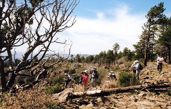
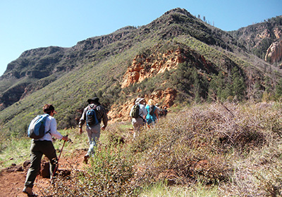 The first wave of Trailblazers leaves First Bench as they head for the summit. [photo by Ajay] |
With the most aggressive part of the trail and the biggest part of the elevation gain now behind us, we strike out from First Bench and continue to make our way to the top of Wilson Mountain. From here it’s another 2.5 miles to the summit but only a bit over 700 feet of elevation gain, so the going will be much easier from here on. The temperature is still holding at a comfortable 70 degrees with light winds out of the southwest to cool us. We couldn’t ask for a more perfect day of hiking. |
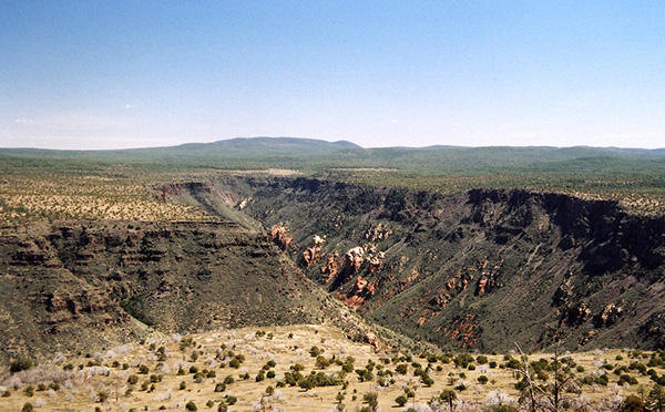 View of First Bench and Munds Canyon from the trail. [photo by Chuck] |
|
After several more switchbacks up the trail, the views open up to show First Bench spread out beneath us as its rim drops off sharply into Munds Canyon, one of the major tributaries of Oak Creek Canyon. |
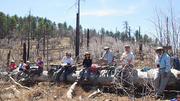 We gather for lunch near the top of Wilson Mountain. [photo by Quy] |
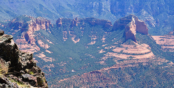
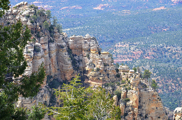
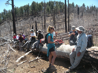 A mighty ponderosa log provides the perfect lunch spot. [Ajay] Unfortunately, both our log bench and much of the surrounding terrain near the mountain top fell victim to the Brins Fire. Somehow, though, the large stand of pines directly behind us was spared and in the coming years will help replenish the devastated forest on this mountain. After lunch we make the short 3/4 mile hike out to what most hikers will probably agree is the best view from Wilson Mountain – the Sedona Overlook, providing sweeping and breathtaking views of what geologists refer to as the Schnebly Hill Formation, with the town of Sedona nestled at its base to the south. The Schnebly Hill Formation consists of an eclectic collection of colorful Coconino sandstone pinnacles, buttes, columns, and spires that together form what is arguably the greatest collection of the signature red rocks that define the very essence of Sedona. |
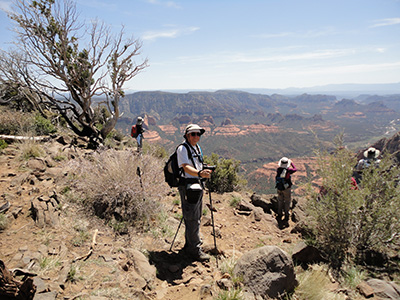
 Trailblazers gather near the scenic Sedona Overlook. [photo by Chuck] |
|
Farther to the south lie the Bradshaw Mountains near Prescott, while still further away to the southeast on a clear day you can make out the rugged and imposing Mazatzal Mountain Range. |
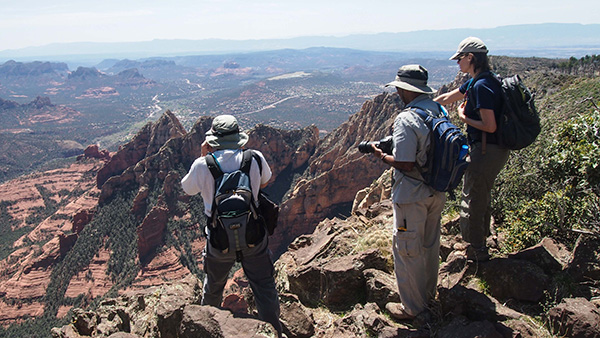
 Photographers try to capture the moment. [photo by George] |
We take another long rest break here as hundreds of pictures are snapped in an effort to capture the magic of the moment on top of Wilson Mountain. We’ll let the following pictures speak for themselves. Because in this cathedral-like setting, perhaps more than anywhere else in Arizona with the exception of the Grand Canyon to the far north of us, the old adage of a single picture being worth a thousand words rings true. |
 Chuck, Ajay, and Anikó savor the moment. [photo by Quy] |
 Fifteen Arizona Trailblazers gather at the edge of Sedona Overlook. [photo by Chuck] |
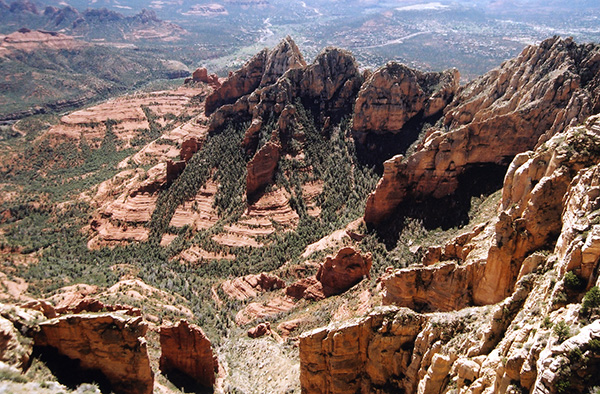 The Big View from Sedona Overlook. [photo by Chuck] |
 Close-up from Sedona Overlook. [photo by Chuck] |
 The Red Rocks of Sedona as you’ve never seen them before! [photo by Ajay] |
 Yet another inspiring view from Sedona Overlook. [photo by Ajay] |
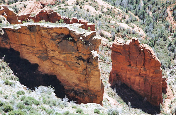
 Massive columns of white Coconino sandstone stand guard over the canyon far below. [photo by Ajay] |
 Midgley Bridge lies 2,300 feet below and to the south of Sedona Overlook. [photo by Ajay] |
|
The parking area just off the north end of the bridge marks the trailhead for both the Huckaby Trail and the Wilson Mountain South Trail #10. |
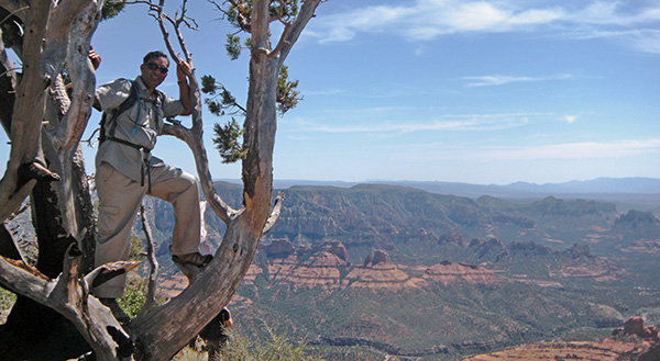 Well, what can we say here? [photo by Ajay] |
 Ajay stands next to a massive burned-out juniper. [photo by Ajay] |
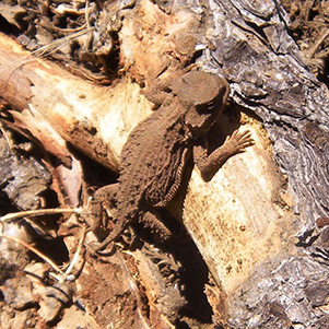 Mr. Horny Toad patiently poses for Mr. Ajay. [photo by Ajay] |
|
Through a strange twist of nature, two ancient junipers have somehow managed to grow together as one. The larger juniper next to Ajay is now nothing but a burned-out hulk of its former self, totally charred on the inside but relatively unscathed on the outside, while its smaller cousin to the rear mysteriously remains healthy and green. Yet another example of how life in the natural world can hang on and even thrive in the face of seemingly insurmountable odds. |
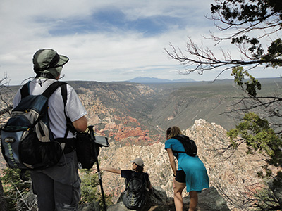 Chuck, Anikó, and Lori enjoy the view from the North Rim Overlook. [photo by George] We certainly aren’t disappointed, with sweeping views from the North Rim of Oak Creek Canyon meandering away into infinity and the snow-capped San Francisco Peaks rising on the distant horizon. |
 Parting view from the North Rim Overlook. [photo by Chuck] |
|
All too soon, we have to start heading back ourselves and become the second wave of Trailblazers making our way back down the trail to the Wilson Mountain North Trailhead, 4.3 miles down the mountain. I take one last look at my thermometer and find that it’s still sitting on 70 degrees where it’s been for most of the day. What a perfect day for hiking! After we all arrive safely back at the trailhead, Gary tells us that we have hiked a total of 10.8 miles today according to his GPS readings – that is, those of us who did the hike out to the North Rim Overlook. After the hike most of us stop off at the Hideaway in Sedona for a light dinner before making the long drive back to our home in the desert. |
 Top of Page
Arizona Trailblazers Hiking Club, Phoenix, Arizona
Comments? Send them to the AZHC .
updated November 4, 2019