Outdoor Links
Hike Arizona
Trip Planning Guide
Trip Report Index
Calendar of Events
Library
|
Perl Charles PLUS Day Hike Dreamy Draw Recreation January 5, 2013 by Wendy Rennert |
|

|
||||
|
||||
|
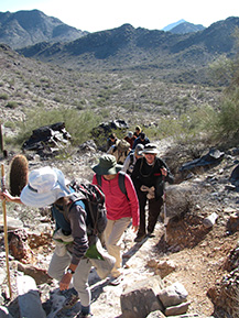
Brrr!! We were a bit chilly waiting for everyone to gather at the Dreamy Draw Recreation Area trailhead, but 13 Trailblazers looked forward to the first hike of 2013. Due to the large amount of unmarked trails that we would be passing along the way, we handed out a number of walkie talkies and asked everyone to not get ahead of the lead or behind the sweep. |
|
The first leg of the journey was up the widest part of the trail, which was actually part of Trail 100 (Charles Christiansen), with washes on either side of us. We passed 2 signs saying 1A (The Perl Charles Trail) along the way before reaching a 3rd sign for 1A, just past the 1st saddle. Not long after that junction, we reached the Irregular Link, also known as Trail 1C, and as we ascended on 1C we started getting good views of the valley we just traversed and all of the unmarked trails in the area. |
 Leaving the oddly named “Irregular Link” to become “Regular” again. |
|
After reaching a second saddle, we continued down the other side, welcoming a little bit of sunshine, and met up with another part of the 1A trail, which was also the junction of the 302 Circumference/Freedom trail. “We’ll see this intersection again later in the hike,” Wendy pointed out, as our route was not a simple loop, but included 2 crosscut trails (the aforementioned “Irregular Link” and the upcoming VOAZ trail), which I think are 2 of the most scenic parts of the route, not to be missed. We could see the switchbacks laid out above us, which led to our 3rd saddle. There were many nice stone benches all along our route, and this particular saddle had two benches, which enabled us to set up the mini tripod and timer so we could all get in the group photo. We paused here long enough to soak in some welcome sunshine and were finally starting to warm up enough to take off our first layer of clothing. Down we go again until we reach the VOAZ trail, at which point we take a left, and soon come to another bench just off of the trail. This area also had a lot of nice flat, smooth rocks for our large group to sit and have a quick snack break. We walked all the way out to the edge to check out the views from the cliff. We couldn’t help nicknaming it the Fiscal Cliff (don’t jump off the Fiscal Cliff!), since that’s all you hear about lately, which led to another nickname of the Physical Cliff. |

|

|
| Oh, so that’s where that darned Fiscal Cliff is! | |
 A probable impostor, but made you look! At the bottom, we reached the 1A again, and continued southeast around the base of the mountain in a nice flat, mellow part of the trail, perfect for getting a second wind for the second half of the trip. Another short uphill brought us to our 5th saddle (mini-saddle, really) and another bench. At this point the trail forked and we took the upper fork, past a nice quartz outcropping and looking down at the valley below, with intermittent teddy bear cholla fields. At the next junction, we took a right turn for a short jaunt on part of the 304 Nature Trail, before joining up again with the 302 Circumference/Freedom Trail. |
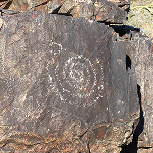
 Geologic art |
 Feeling the burn – a good workout! |
|
Up we go again, passing the VOAZ trail that we had taken earlier, so it was déjà vu going back up to that saddle with the 2 benches. Saddle #6. This time we went past the Irregular Link Junction and continued on the 302 / 1A. |
 Decisions, decisions — So many possibilities! |
 A jagged descent down the 302 Circumference/Freedom Trail |
When we made it to the second bench on this trail, this was where the 1A and 302 split, and we took the 1A down and across a wash. With many trail choices at this point, we opted to take a left turn and continued on the 1A now heading towards the 51 freeway. On the way to our 7th saddle, we saw a shell of a small stone building that may have been part of what was left from the mining operations. No one seems to know for sure though. At this point we could see the houses that back up to the Preserve area. |
 Mystery building |
|
As luck would have it, at the 8th and final saddle we came across a woman hiker who had a beautiful Macaw on her shoulder – no leash or anything preventing it from flying away. I have seen many odd things on the trails over the years (including 2 unicyclists and a barefoot hiker), but this was a fun little encounter. She let us take turns holding the bird and taking our photos. Very tame and gentle. The last stretch of our route parallels the 51 freeway, and brought us back to the trailhead. |
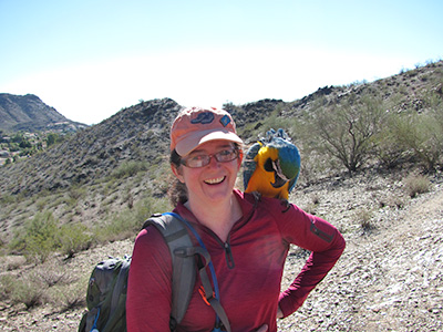 Wendy’s new friend. |

|

|
| Our new pal brightens our day. | |
|
Once I got home from the hike I found out that the origin of the Dreamy Draw name comes from Phoenix’s Territorial days. The former Rico Mercury Mining and Processing Site used to be located on the western flank of the Dreamy Draw area. The story goes that after a long day deep in the mines, the men emerged appearing somewhat inebriated and dreamy-eyed from inhaling the mercury fumes. As they walked down the dusty road to the general store, people were heard to remark, “The men are back from The Dreamy Draw.” |
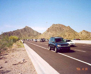
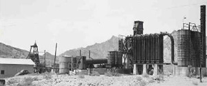 Above: Former “Rico” Mercury Mining and Processing Site. Head frame on left of Rico Shaft, Hartman Condenser apparatus on right. (Photo courtesy of AZ Dept of Mines & Mineral Resources) Right: the site as it appears today. Northbound SR 51 at the approach to the Northern Avenue Overpass |
|
|
Mexican Restaurant Aunt Chilada’s North Room was built on the foundation of that general store, which was the only general store serving the laborers of this mine. Coincidentally, just like those early miners, some of our group went to the same location after our hike for a relaxing lunch out on the patio. Thank you Michael for being our sweep – you did a great job of keeping track of everyone! |
 Top of Page
Arizona Trailblazers Hiking Club, Phoenix, Arizona
Comments? Send them to the AZHC .
updated May 28, 2020