Outdoor Links
Hike Arizona
Trip Planning Guide
Trip Report Index
Calendar of Events
Library
|
South Rim Camping Trip Grand Canyon National Park May 9-11, 2014 by John Richa |
|

Turn here for high adventure!
These mountains are the tallest in Arizona. They are a volcanic mountain range located in north central Arizona, just north of Flagstaff. The highest summit in the range, Humphreys Peak, is the highest point in the state of Arizona at 12,633 feet (3,851 m) in elevation. The San Francisco Peaks are the remains of an eroded stratovolcano located within the Coconino National Forest. |
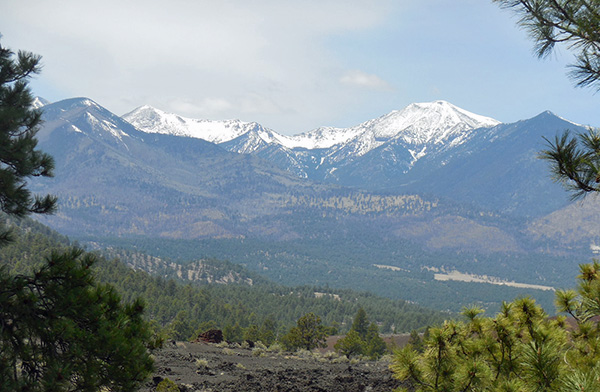 The San Francisco Peaks are snow-capped in mid-May. |
|
This group of trailblazers did not drive up to the GC in a caravan, as sometimes is the practice, but rather each carpool started out at different times and some took the non-direct route to the GC. Our destination though was Mather Campground at the GC by 4:00 PM. Arizona is full of contrasting phenomenal geography, geology and history and one is amiss if you drive by these places of such interest and not visit them. Dottie and John followed their heart and took 89 east of Flagstaff in order to visit a couple of points of interest. |
 Where do you think the next eruption might occur? |
 This was all liquid when the volcano erupted. |
 Dottie enjoys the volcanic view. |
|
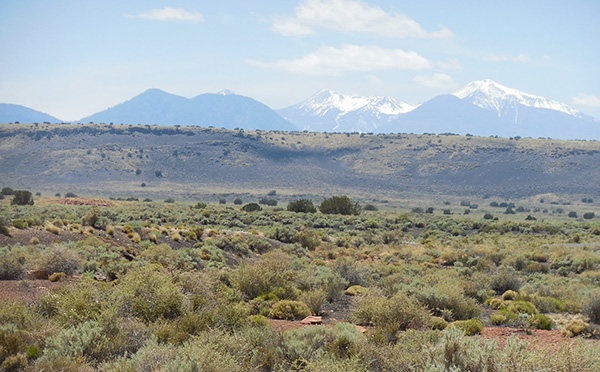
We first came upon the Sunset Crater Volcano National Monument where 1,100 years ago there was a volcanic eruption during which a 2.5 miles lava flow oozed from the crater. Down in the valley, the lava flow got cold and the liquid magma turned into black and porous hard rock called “basalt” rock. The surrounding mountains were covered with volcanic ash or cinder. Centuries later, new vegetation started to rejuvenate the volcanos’ slopes. |
 The Anasazi didn’t need a sign ... |
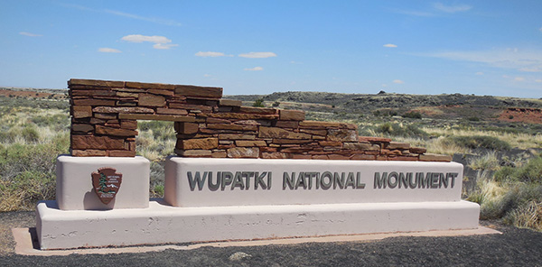 Native stones were used to construct the National Monument marker. |
|
Farther to the northeast, native Indians built their pueblos in the shadow of the volcanos. Two such are the Wukoki Pueblo and the Wupatki in the Wupatki National Monument. The descendants of these original Indians still live nearby on the Colorado Plateau, including the Hopi, Zuni and Navajo people. |
 Sightseers on the road to ruins. |
 Do you know the meaning of “Wukoki”? |
 Dottie explores the ancient dwelling. |
 This is what the native Indians would see from their pueblos. |
|
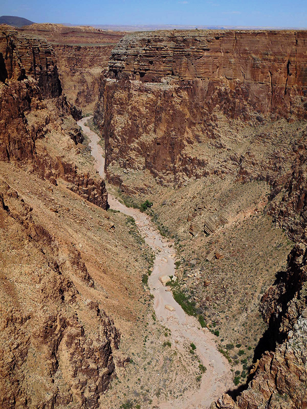
From here we quickly rejoined Highway 89 northbound towards Cameron Trading Post, where, at the intersection with Rt. 64, we turned westward towards the GC National Park entrance – but not before stopping at the Little Colorado River Gorge. Once upon the time the river was powerful enough to create this gorge. Today, it is totally dry. |
 Do you suppose there’s something to see over there? |
 Wow! |
|
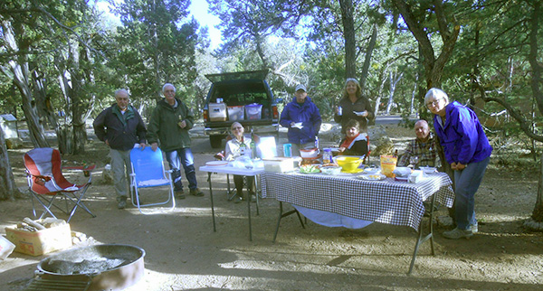
The river is the principal drainage from the Painted Desert region. Together with its major tributary, the Puerco River, it drains an area of about 26,500 square miles in eastern Arizona and western New Mexico. This Colorado River tributary is over 315 miles long, but being a transient desert river, its average discharge is typically less than 400 cubic feet per second and can vary greatly throughout the year. The drive form the river level to the GC village at the South Rim was a constant climb from a low of 4200 feet at the gorge to about 7,200 ft. at the campgrounds. There were many scenic overviews. The drive through the coniferous forest was beautiful. We arrived at the campgrounds at about 4:30 and met our Trailblazers’ campers. Chuck and Monika had already pitched their tents and were relaxing by drinking a cold beer and munching on peanuts-in-the-shell. Susan and Roger were in a nearby site and they came over to meet us. Doug and Corinne were also in a nearby site and came over to meet everyone. Housing chores accomplished with the tents pitched up and the bedding organized, it was approaching 6 o’clock and it was time to think about dinner. |
|
|
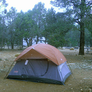
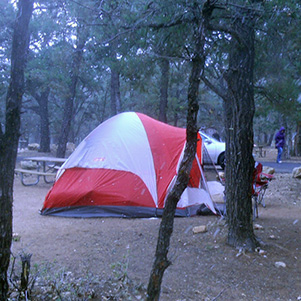
| Good places to pitch a tent at Mather Campground. | |
 Doug’s Marriott Hotel on wheels! |
|
Our pot luck dinner was scheduled for Saturday. After a few minutes of discussing our dinner options we decided to dine at the Maswick Lodge where several menu options were available at this quasi food court. We shared our dinner hour at the pizza parlor. Back at the campsite we huddled around the fire pit. |
 Roger, John, Doug, Corinne, Chuck, Monika, Dottie, Susan. |

John, Corinne, Dottie, Monika, Susan, Roger.
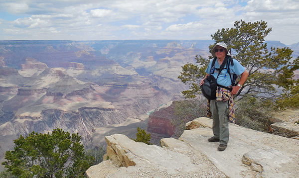
We discussed the following day’s itinerary. The plan was to hike the Rim Trail westward of the GC Village South Rim all the way to Hermit’s Rest. For most of us it would be the first time reaching Hermit’s Rest. Back in October of 2010, the club undertook a similar camping trip and on one of its day hikes, was to hike to Hermit’s Rest along the Rim. However, 1.5 miles before reaching Hermit’s Rest, a thunderstorm with lightning and thundering blew over the Rim and the hike was cut short by taking the shuttle bus back to campgrounds. This time, though, and especially for Chuck, reaching Hermit’s Rest is a must. The weather was ideal: no precipitation, high intermittent clouds, breezy with wind gust of 15-20 mph. with temperature in the upper 60s and low 70s. A cold front was moving in from the northwest, but not until Sunday night would the temperature drop into the upper 20s with no precipitation. That remains to be seen. |
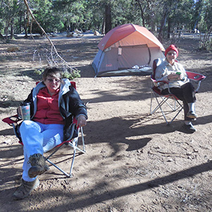 This is the life! |
 A wilderness chef’s delight. |
|
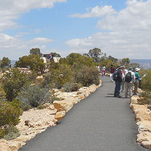
Saturday morning around 7:00 o’clock we started to stir. The sun was out with a light breeze. It was cold. We set up our “mess hall” and ate a warm breakfast and drank hot coffee. By 9:30 AM we were all saddled up and proceeded towards the bus stop, a half-mile trek down the campgrounds. We were shuttled to the Hermit’s Rest Trailhead, where at 10:00 AM, we began our long trek of nine miles to Hermit’s Rest. Along the way there were several overlooks points. The trail was blacktopped for a good portion of it, then it became a dirt trail but well maintained and the last 2.7 miles it became paved again. All along the trail the bus route shadowed the trail where visitors could get on and off the bus at any of the nine overlooks. The first overlook was “Trailview Overlook” at 0.7 miles from the starting line. The view from this vantage point was superb, because not only you could see the “village” profile to the East but also 4.5 miles down the Bright Angel Trail, an “A” trail, meaning very difficult trail to hike. All along the first 1.5 miles of the Rim Trail there were geological markers implanted in the black top with incrementally increasing number of years indicating various geological eras where 1 meter in elevation equal 100 million years and each 1,000 million years is one billion years in geological terms. This is the “trail of time”, where the Grand Canyon Village rock formation is 2,000 million years old, i.e. 2 billion years old. At this trail view spot, the rock formation is 2,930 million years old and the Grand Canyon itself is 4,560 million years old. |
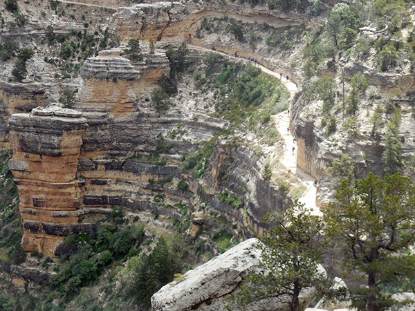 Starting point of Bright Angel trail. [photo by Chuck] |
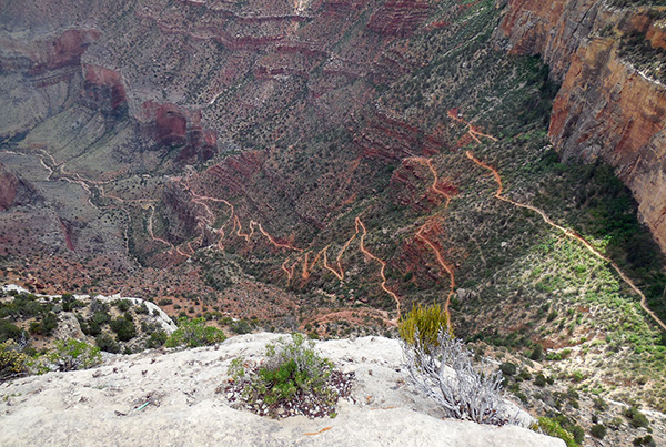 Bright Angel Trail snaking its way down 4.5 miles to the Indian Garden “oasis”. [photo by John] |

It is maybe not so old in terms of the “Big Bang” and the beginning of the Universe. The following marker is just one of many along the trail of time and simply indicates the geological time to be about 2,950 million years. These pictures show the various strata of rock formation of the GC: white is lime rocks, and is characteristic of the Kaibab Formation which is the top layer of the GC. The following picture is a complete list of the various strata of the GC. This is your geology course in a nutshell. |

|
 Wotan’s Throne can be seen on the northeast horizon. [photo by Chuck] |
 Erosion did this, over the ages. [photo by Corinne] |
|
The next overlook was Maricopa Point then came Powell Point in honor of the Grand Canyon explorer John Wesley Powell, a “one arm” explorer (he lost his right arm during the Civil War), who explored the GC and its many smaller canyons. He descended the River with his party of row boats traversing the Gorge beneath this point on 8/17/1869 and again on 9/18/1872. |
 Approach walkway to Powell Point. Trailblazers read historical poster sign. [photo by John] |
 Approach to Powell Point Monument. Monika comes down the stairs. [photo by John] |
 Trailblazers rest and pose for group picture at Powell Point. [photo by John] Doug, Susan, Chuck, Monika, Corinne, Dottie, John, Roger. |
 “The Girls” at Powell Point. [photo by John] Corinne, Dottie, Monika, Susan. |
|
At about 12:30 we decided that we had built up enough of an appetite and hence stopped along the trail for a lunch break. We continued forward our trek. While Chuck is looking westward, determined to reach the once before elusive Hermit’s Rest. |
 Hermit’s Rest, here I come! [photo by John] |
|
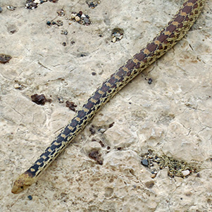
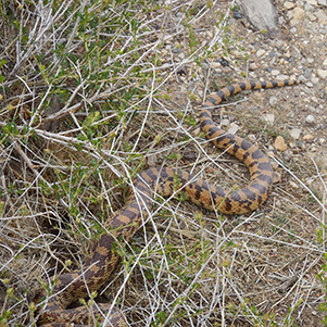
The flora of the south rim is primarily of dwarf forest of pinyon pine and juniper while the fauna although limited, yet quite diversified. Some of the fauna on the South Rim are the swallows, ravens, candors, pinyon jays, Steller’s jays, hairy woodpeckers and wild turkeys. One will also find the cliff chipmunk, mule deer, Albert’s and Kaibab squirrels, mountain lions, desert bighorn sheep, beavers and Grand Canyon rattlesnakes. Along the trail to Hermit’s Rest our group came upon a snake. It was a harmless snake, a 5-6 feet long gopher, sunning itself and absorbing heat energy for its hunting forage. As we congregated around it snapping pictures, it started to scurry around and entered a hole at the base of a retaining wall. Our country boy Doug knew right away that this was a gopher and hence not poisonous, and suggested to try to pull it out of the wall by its tail so that we could further admire it. |
|
|
| Snakes alive! Now stay there while I take your picture. [photos by Monika] | |
|
At The Abyss bus stop, Susan, Roger and Monika decided to catch the bus and return to campgrounds. We bid them good-bye and proceeded westward towards Hermit’s Rest, some 4 miles away. I can sense Chuck’s determination to make it to the end this time. At the next bus stop, Monument Creek Vista, Dottie and Corinne decided to head back to campgrounds and save some energy for next day’s hike. From that point on there were only 2.7 miles left to reach Hermit’s Rest. We were down to three determined hikers: Chuck, Doug and John and we were determined to make it to the end. We kept on trekking and as the posted “distance markers” to Hermit’s Rest kept shrinking on us, the more we savored victory at hand. And finally we reached mile marker 0.0. |
 This is it. [photo by John] |
 Chuck and Doug at Pima Point. [photo by John] |
 The view from Pima Point. [photo by John] |
 The crowning of our effort: Chuck, Doug and John under the “arch of triumph”. [photo by John] |
 Chuck and Doug in front of the gift/coffee shop at Hermit’s Rest. [photo by John] |
|
Note the “victory bell” over our heads and the inscription in the rock. While making our way to our destination, all three of us talked about celebrating our victory by buying three beers at the coffee shop and having someone take our picture while toasting ourselves. When Doug inquired from the coffee shop clerk about beer sale, he was told that the store did not sell any alcoholic beverages. It was disappointing. This hard-earned beer would have tasted the best ever! At 4:20 we boarded the return shuttle bus and headed back to the campgrounds. It is now 5:30 and we were all very hungry and in full anticipation of a scrumptious pot luck dinner. Our menu included 3 beans salad by Chuck, shrimp, dip and chips by Dottie, Chili by Susan and Roger, crab salad by Doug and Corinne, cut up veggies and barbecued chicken drumsticks by John, wine, beer, cream cheese and cracker, peanuts-in-the-shell, potato salad etc. It was all very delicious and we helped ourselves to multiple servings. All these burned calories had to be replaced for next day’s hike. After dinner, we built our pit fire and sipped on wine and drank beer. It was a cold night and windy. |
 The hike’s over. Let’s enjoy our put-luck! [photo by John] John, Doug, Dottie, Roger, Corinne, Monika, Chuck, Susan. |
 Chuck and Dottie. |
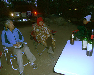 Corinne, Dottie, and Monika. |
| The perfect ending to a perfect day. [photos by John] | |
|
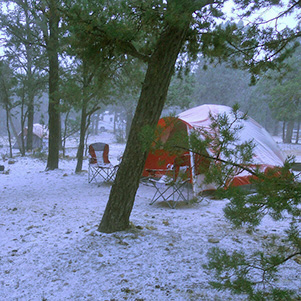
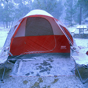
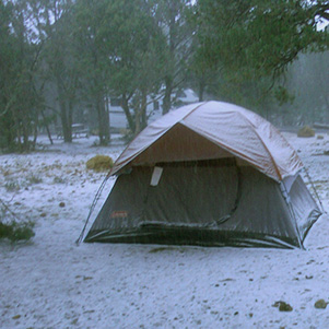
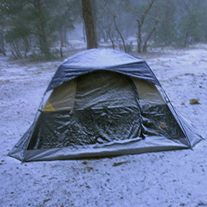
Looking up at the dark and threatening clouds, Corinne kept reassuring us that she read the weather forecast on her iPhone. It was going to be cold tonight and tomorrow but zero chance of rain. Well, we woke up early in the morning hearing the sound of freezing rain coming down on our tents. Soon thereafter, snow started to come down and the wind was howling. Snow started to accumulate and things were getting wet and the campgrounds a little muddy. Chuck, Monika, Dottie and John huddled together to discuss what were our options for breakfast and for the rest of the day. It was too wet to prepare our breakfast at the campgrounds. So the alternate decision was to go to the Yavapai Lodge cafeteria and have breakfast there. So, Chuck and John drove down to the campgrounds office to read today’s weather report that is usually posted daily on a bulletin board. The office was still closed and the information posted was a day old but not reassuring. We then drove up to the Yavapai Lodge to check out the menu. It was rather very good, with many options. We get back to camp and inform the rest of the group. |
| We thought we were going to be snowed, but like this? [photos by John] | |
|
|
|
|
 I know what to do. [photo by Monika] |
|
At the cafeteria we linked up with Susan and Roger and had a nice social hour. Susan and Roger were going to return to Phoenix one day earlier regardless of the weather anyway. Doug and Corinne were cozily still asleep in their Marriott Hotel on wheels. We never saw them at breakfast but we did call them and tell of our unanimous decision to return to Phoenix because the weather was threatening and that we did not want to get caught in a rain storm in the open. Doug and Corinne itinerary was to continue on with their private trip to California after their Grand Canyon camping trip. After breakfast, we took a farewell drive to the El Tovar Hotel to admire the Grand Canyon during a snow storm. While the snow has not stuck to the ground of the Canyon, the clouds were ominous, dark and threatening, the wind was blowing hard and it was cold. |
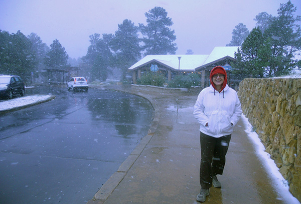 Dottie at Yavapai Lodge. [photo by John] |
 Storm clouds a’brewing ... [photo by John] |
 Glad we’re up here instead of down there. [photo by John] |
 Parting shot, before we start for home. [photo by John] Susan, Roger, Dottie, John, Chuck, Monika. |
|
At the campgrounds, we quickly took down our tents and packed everything in our cars. Snow was still coming down. We said our good byes and proceeded to drive back home to Phoenix. At a refueling stop in Flagstaff, the news report at the station said that the temperature was 30 degrees but it felt much colder because it was very windy. In the meantime, Doug and Corinne waited out the weather and later on in the day the weather became fair enough that they ventured out and down to Cedar Ridge, which is a 1.5 miles down the South Kaibab Trail. We missed this hike but vicariously hiked it through Doug and Corinne. |
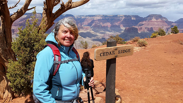 I made it to Cedar Ridge, so there. [photo by Corinne] |
 Dottie and Corinne made it to Hermit’s Rest. [photo by Corinne] |
|
Oops! Wow! What’s that? We thought that only the three “guys” made it to Hermit’s Rest and we had the proof of it! How did these two girls get there? It must have been a “Biblical Transfiguration”! No comment. We’ll just leave it at that. It was an exciting camping trip with a weather event surprise. But that what makes it even the more exciting – unpredictability! We had good company and shared good food and a chance to get out of town, hiked a beautiful trail and saw the Grand Canyon Vistas along with the majestic Colorado River. These GC views never get old but always remain mesmerizing. One never has enough of the GC. We promised ourselves that we will be back and soon! |
 Top of Page
Arizona Trailblazers Hiking Club, Phoenix, Arizona
Comments? Send them to the AZHC .
updated April 28, 2020