Outdoor Links
Hike Arizona
Trip Planning Guide
Trip Report Index
Calendar of Events
Library
Cave Creek Regional Park
February 22, 2014
by Jim Buyens
|
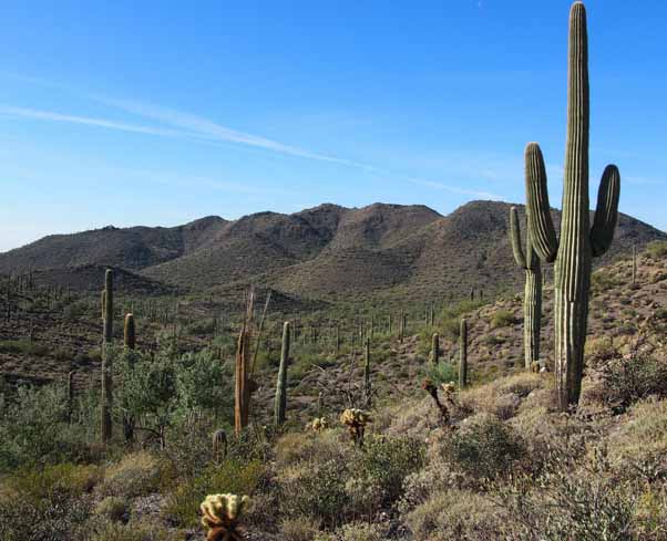
The Go John Trail in Cave Creek Regional Park is one of the most popular and best-maintained in the Valley. It's part of the Maricopa County park system which seems to have its own stream of revenue, shielding it from financial ups and downs, and from politics. The northern border of the park adjoins a large expanse of state trust land that provides wonderful scenery without urban distractions. The trail was named after one G. O. John, a miner from around 1900. Not much is known about him except that a gold mine, a mountain, a canyon, and the current-day trail all carry his name. The current-day Go John Trail is a well-groomed loop of 5.8 miles with a total elevation of about 800 feet. I wanted a longer hike, though, and so I picked a route through the Slate and Quartz trails, which cut wide on the east, and the Overton trail, which cuts wide on the west. Between those two we hiked the north side of the Go John, which is arguably the most interesting part anyway. It's certainly the most natural and most scenic. The final distance was 7.9 miles.
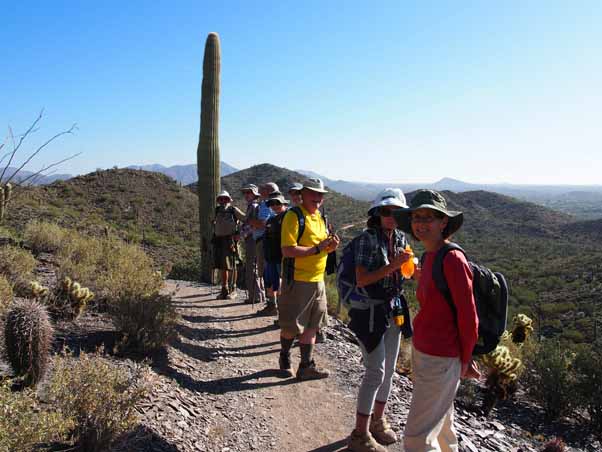
Thirteen trailblazers came out for the hike, including two from Edmonton, Alberta, Canada. The Canadians had gone on a hike with Wendy Rennert about two years earlier and had such pleasant memories that they wanted to hike with us again. Go Wendy! The park charges $6 a carload, so most of us met at the McDonalds at I-17 and Carefree Highway to consolidate vehicles. Four others joined us at the trailhead. We arrived around 8:30 and to our surprise found the place choking with cars! A group called Aravaipa Running was staging a trail running event that attracted hundreds (if not thousands) of participants! The event was called Elephant Mountain Trail Runs and it offered distances of 12, 22, 35, and 50 km! Now, 50 km is 31 miles! We were looking at eight miles of hiking being a good workout and these folks were running nearly four times that distance! How's that for intimidating?
I was afraid that parking at the Go John trailhead was going to be used up, forcing us to scramble for a spot and then valiantly search for each other in the teeming masses. Fortunately, though, the trailhead was some distance from the trail run start/finish point and had enough spaces. So without further ado we booted up, packed up, snapped a group photo and headed out.
For starters we hiked about three quarters of a mile on the Slate trail which, for the most part, was gently undulating. Next, however, was the Quartz trail, which involved 1.4 miles of mild but continual elevation gain.
We then joined the Go John trail, the first mile of which was noticeably rockier and steeper than the first two. We took frequent breaks to catch up and make sure everyone felt OK to continue. The trail runners, meanwhile, kept sprinting past us in the opposite direction.
We reached the top of the climb at about 10:15 and then stopped at a flat outcropping for a snack break and a chance for everyone to get their wind. Some people were huffing and puffing pretty good but they all said they were OK.
After the break we continued around the Go John trail, which at that point was mostly downhill and quite scenic. A few spots were a bit rocky and steep but everyone managed OK.
At the bottom of the Go John descent we stopped for another snack and rest break, and then we continued south (and once again up) as the trail looped around. This was a gentler ascent than the steeper sections of the Go John trail, and had a nice smooth surface. Then, about a half-mile from the saddle at the top, we veered east onto the Overton trail. From here it was almost all downhill to the trailhead, and with a fairly smooth surface. That's not a bad way to finish a hike. Plus, all the trail runners stayed on the Go John trail, leaving the Overton much less crowded. After the hike most of us reassembled at El Encanto Dos, a pleasant stop along the way back to our initial meeting place. The food was fresh, well-prepared, and tasty, and the refreshments were welcome. Good hike!
|


| Hike Statistics | ||
| Total Distance: | 7.91 miles |
|
| Moving Time: | 2:44 hours | |
| Stopped Time: | 1:19 hours | |
| Moving Average Speed: | 2.9 mph | |
| Total Average Speed: | 1.9 mph | |
| Starting Elevation: | 2120 feet | |
| Maximum Elevation: | 2528 feet | |
| Total Elevation: | 930 feet | |
| Starting Time: | 8:51 AM | |
| Finishing Time: | 12:54 PM | |
| Starting Temperature: | 52° | |
| Finishing Temperature | 70° | |
 Top of Page
Arizona Trailblazers Hiking Club, Phoenix, Arizona
Comments? Send them to the AZHC .
updated December 31, 2019