Outdoor Links
Hike Arizona
Trip Planning Guide
Trip Report Index
Calendar of Events
Library
|
Dripping Springs Day Hike Superstition Wilderness January 24, 2015 by Dave French |
|
 Wayne, Chuck, Eileen, Jim, Christina, Sana, Florence, Quy, John, Susan, Denise, Michael, Rudy, Andy, Mark, Tamar, Sandy, Dave, Barry |
|
Some trips start out great and end with a thud and others start out rough and end great. This trip falls in the latter category. Nineteen AZ Trailblazers and guests met in the Home Depot parking lot just before 7:00 AM on a cool, crisp, clear day. We promptly got everyone signed in and managed to get all 19 into four vehicles. Thanks to Michael, Andy, John and the trip leader for driving. |
 Double barrel saguaro. |
 Irish green grass. |
 Sycamore Tree. |
 Rudy and the newspaper. |
|
We drove east on US 60 for about 25 miles, just past Florence Junction to Queen Creek Road. Then we headed up the road and turned onto FR 357 which is not paved but graded. After 3 miles we turned onto FR 172 to go 11 miles to the trailhead. This road is also unpaved and quite rough in some spots. A high clearance vehicle is required but 4-wheel drive was not needed. After bumping and jiggling for 45 minutes or so we reached the parking area. Then the fun began. |
|
We stepped out of the cars into a 50 mph wind from the east. The wind was so strong that it was difficult to open the doors on the east side of the vehicles. It was about 50 degrees and the wind made it feel colder and made it difficult to get our gear on, communicate, and get started. We knew we would be heading down into a canyon and hoped for calmer conditions, so we postponed the introductions and initial instructions and literally flew down the road with the wind at our back. We reached the trailhead gate on FR 172B, climbed the gate as instructed by the hiking book, and headed down the road that leads to the JF Ranch*. |

|
|
About a quarter mile down the road, we realized that we were missing one hiker. Given the strong easterly wind, no one bothered to look behind them at the parking area. |
 Eileen explores the dripping springs area. |
 The caves viewed from dripping springs. |
 top row: Barry, Sana, Sandy, Florence, Jim, Denise (hidden), Mark, Chuck, Andy, Susan, Tamar, Eileen bottom row: Dave, Christina, Wayne, John, Quy, Rudy, Michael. |
|
Some hikers went back to the gate, from which you could see the parking area, but no sign of the missing hiker. Two of the hikers climbed back over the gate and walked against the strong wind back to the cars, where they found the hiker huddled down out of the wind. Apparently he had taken an unannounced pit stop, lost sight of the rest of us, and decided to stay put. We were all relieved that there were no medical issues and all 19 hikers reconvened and proceeded to the JF Ranch. The corral is still very much in use. The gates are open for the cattle to come in to water at the trough. The trail goes around the corral and people need to go through the wire gate. We decided not to spend time around the ranch due to wind and the lost time we had already incurred, so we proceeded down the 108 Coffee Flat Trail into Frazer Canyon and got out of the wind. We stopped for a group picture and then moved on. The wind no longer was a factor. The sun was bright and warmed us up quickly, and all was well. |
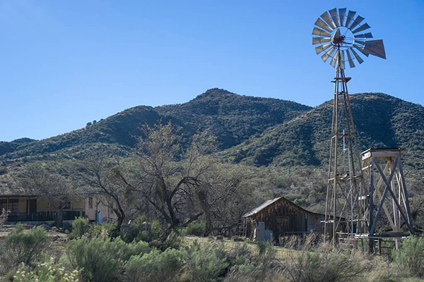 JF Ranch. [photo by Wayne] |
 Dripping Springs, here we come! [photo by Wayne] |
 Reflective pool along the trail. [photo by Wayne] |
 Quy and Wayne explore the caves. [photo by Eileen] |
 Overhang looks out to Dripping Spring and a lush green valley. [photo by Eileen] |
|
We proceed down the trail, which is fairly easy to follow except for a few wash crossings where some of us missed the trail but eventually got back on it. The trail sometimes follows the wash and sometimes deviates quite a ways away. About 2/3 of the way in, the trail goes quite high on the northern side of the canyon and follows the old freight wagon route that was used to haul supplies and ore between Mesa and Superior in the 1800s. Some rock retaining walls were still evident. |
 Wayne. “On this rock I stand.” [photo by Quy] |
 Dairy Queen saguaro. [Eileen] |
 Quiet water reflects on life. [photo by Quy] |
|
The scenery in the canyon is quite spectacular, with hoodoos and rock formations particularly on the north rim, great stands of saguaros on the south facing slope, and dense trees, bushes and brush in the canyon bottom. The rock coloring in the stream bottom was particularly noteworthy, with colors that varied from steel grey to maroon to highly speckled. The trail is often used by horses, so is narrow and reasonably well traveled; however, brush overhangs the trail in many places. There were catclaw and other thorny bushes as well as plenty of cacti, so long sleeve shirts and pants are highly advisable. One hiker brushed up against a cactus and others helped remove the thorns. Eileen says a baking soda paste works well to remove those tiny thorns that are almost impossible to see. |
 Finger Rock. |
 Junction of Frazer and Randolph canyons. |
 Arch viewed from trailhead parking. |
|
We reached the junction of Frazer Canyon and Randolph Canyon at 12:30 PM. Dripping Springs is the rock wall along the south side of the canyon and extends westward for several hundred feet. There were no drips today but there were pools of water and some small trickles of running water in Randolph Canyon. The large, smooth red rocks in the canyon bottom made a great place to sit for lunch and rest. Some of the hikers climbed up to the caves on the north wall of the canyon, but most of us just rested. After lunch we took another group picture and then headed back the way we came — well, almost. As noted in the GPS track, we did depart from the path in some places but never too far and not with any great difficulty. |
 Relaxing at Old Chicago restaurant. |
|
We travelled quickly back up Frazer Canyon to the JF Ranch and then started the climb up FR 172B to the trailhead. The climb up is long and unrelenting, challenging some of the hikers, but everyone made it. One vehicle loaded and left quickly because the driver had an evening engagement. The other three drivers took our time, and then moved up to the gate area to pick up the last of the hikers. We returned on the 11 miles of bumpy road without incident and reached the Home Depot parking area about 5:30 PM. Eight of the hikers went to Old Chicago across the street and had well deserved cold drinks and supper. All’s well that ends well. JF Ranch is still a working cattle ranch just outside the Superstition Wilderness. The buildings are owned by the National Forest Service, but the ranch is operated by permit by a private rancher. That is why the gate at the start of FR 172B is locked and we have to climb over. A windmill provides water. There are some historic shoeing equipment and other artifacts available for viewing. Source: Hiker’s Guide to the Superstition Wilderness by Jack Carlson and Elizabeth Stewart, 2002, pages 283-288. |
 Top of Page
Arizona Trailblazers Hiking Club, Phoenix, Arizona
Comments? Send them to the AZHC .
updated July 15, 2018