Outdoor Links
Hike Arizona
Trip Planning Guide
Trip Report Index
Calendar of Events
Library
|
Pass Mountain Loop Day Hike Goldfield Mountains March 7, 2015 by Andy Zaharchuk |
|

|
| Sana, Laurie, Monika, Debbie, Michael, Gary [photo by Andy] |
|
Shortly after gathering at Red Mountain Park on East Brown Road, we drove to our trek starting point at the Meridian Trailhead. Meridian Road dead-ends at the trailhead parking area. Parking there is free, and park entry fees are not required, as the trail here is not part of Usery Park proper. Our group consisted of Sana, Michael, Laurie, Gary, Monika, and myself. Our plan would be to do the hike in a clockwise loop, and meet Debbie at the location where the Wind Cave and Pass Mountain Trails intersect, perhaps a mile or so from our starting point. Debbie would accompany us for a portion of the trek, up to the viewpoint on the north side, then return unaccompanied to where she had parked her car in the Usery lot. We soon headed out from the trailhead at Meridian. Before long, it was clear that we were not getting ourselves over onto the actual Pass Mountain Trail, which was located across Sand Canyon, a deep wash having steep sides covered with thick vegetation. There were several intersecting trails there, adding to the confusion. We first headed south, then north, to no avail, even though we knew where the desired trail was located, only a few dozen yards away. Michael finally found the right trail which headed northward and down into the wash, then up the bed of the wash for several yards, and then after a sharp left turn, up the far side. Once on the Pass Mountain Trail, we all carefully noted where this side trail met the Pass Mountain Trail, so we would be sure to find it after completing the loop. |
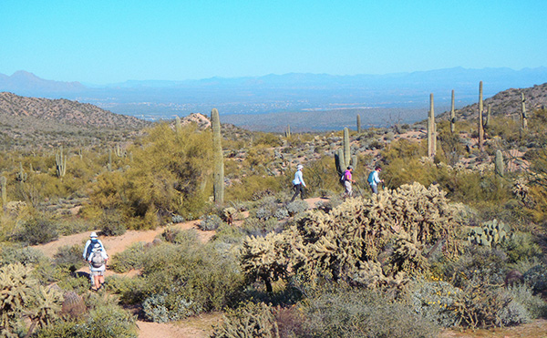 We’ve traversed the bajada section, now let’s head for the pass. [photo by Gary] |

|

|
| A medley of flowers livens our passage. [photos by Gary] | |
|
Now, finally on our way, we made good time and after a mile or so on the right trail, we met Debbie. We soon took off again, and began to see wildflowers. As we proceeded further northward, the wildflowers became more plentiful. |
 Mexican gold poppies brighten the trail. [photo by Andy] |
 Lone Mountain, from the north side of Pass Mountain. [photo by Gary] |
 Saguaro points the way to Stewart Mountain and the Mazatzals. [photo by Gary] |
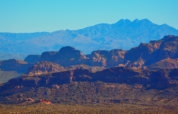 Four Peaks rise in the distance, beyond Bulldog Ridge. [photo by Gary] |
 Meridian Road and Apache Junction, from the pass. [photo by Gary] |
|
While continuing on the northwest portion of the loop, we had an unusual encounter, which none of us had ever come across while hiking. A man riding a small Bobcat backhoe was on the trail, performing trail maintenance. |
 Right on! We’re getting some trail maintenance. [photo by Andy] |
|
After some of us chatted briefly with the man on the Bobcat, we continued on our way and soon reached the viewpoint. There were quite a few other hikers at this place. We stopped there and took some time to enjoy the fine views before us, of places such as Four Peaks, Mount Ord, Stewart Mountain, and Blue Point. Here, Debbie left us and returned to Usery, as planned. We continued on our way along the north side and soon we reached the saddle. There, we again took a short break, and soon thereafter headed south down the trail. It is there that the steepest section of the trail occurs. The trail quickly drops in elevation, and most of the elevation loss on the entire hike loop takes place there. From the saddle southward, flowers were less plentiful, as this section of the trail is more exposed to the sun’s rays. |
 Poppies populate the trail as we head toward Peak 3205. [photo by Gary] |
 Closer to Peak 3205, we can see its bright colors. [photo by Gary] |
|
The east side of the loop is more distant from the Usery Park main facilities, and therefore fewer hikers were seen there. Before long, we reached the place where we would leave the Pass Mountain Trail, and cross over the wash to the trailhead parking area. It warmed up some while we completed the last couple of miles of the hike. We all did well. There were no injuries and we all made it back safely to the starting point. My thanks to the participants for their comradeship! It was a good hike, with good friends. |
 Top of Page
Arizona Trailblazers Hiking Club, Phoenix, Arizona
Comments? Send them to the AZHC .
updated May 28, 2020