Outdoor Links
Hike Arizona
Trip Planning Guide
Trip Report Index
Calendar of Events
Library
|
Inner Basin Day Hike Flagstaff September 20, 2008 by Chuck Parsons |
|
 Arizona Trailblazers pose for a group picture near the Inner Basin Trailhead. [photo by Ted] |
||||
|
 A group of hikers pauses beneath the soaring aspen bordering the Inner Basin Trail. |
Evidently the prolonged summer heat of the desert has prompted many people to get out of Dodge for the day and head for the cool and inviting San Francisco Peaks of northern Arizona. With master lensman Ted Tenny working his digital magic behind the camera, twenty Arizona Trailblazers and guests gather near the Inner Basin Trailhead for a group picture to record this historic moment. Starting at 8,600 feet from Lockett Meadow Campground high up in the Coconino National Forest of northern Arizona, the Inner Basin Trail climbs steadily but gently up a moderate grade through thick alpine forests of aspen, pine, Douglas fir, and blue spruce. At 2.1 miles, the trail finally emerges onto the eastern edge of the vast Inner Basin of the San Francisco Peaks. |
|
Near the first major trail junction at 1.5 miles we encounter the first of two large pumping stations that provide the city of Flagstaff with much of its drinking water supply. A powerful generator and large electric motor inside the pump house pulls ice-cold water from deep beneath the Inner Basin, supplied by the massive winter snows that blanket this area and the surrounding mountain peaks throughout the cold winter months. |
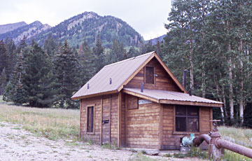 Pump House #1 |
|
Debbie pauses for a rest break along trail’s edge on an ancient tree trunk that provides a perfect place to sit. Now above the 9,000-foot level, the increasingly thinner mountain air is beginning to take its toll on us desert dwellers who are more used to the higher oxygen levels of our home in the Sonoran Desert at about 1,200 feet. |
 There’s never been a log that can throw Debbie! [photo by Ted] |
 Cloud cover over the Inner Basin A pristine and expansive montane landscape surrounded by the towering San Francisco Peaks, the Inner Basin is actually the inside of an ancient collapsed volcano that met its fiery and explosive end many millions of years ago when Arizona was a seething cauldron of volcanic activity. |
 Majestic Fremont Peak rises in the distance to meet the Arizona sky.  Alpine landscape in the Inner Basin. |
The base of a weathered and sun-bleached tree trunk serves as nature’s viewfinder, framing 11,969-foot Fremont Peak. One of the four major peaks surrounding the Inner Basin, Fremont is joined by its sister peaks of Humphreys, Agassiz, and Doyle. Arizona’s four highest mountain peaks are all within view in the Inner Basin, comprising the San Francisco Peaks that serve as a major landmark seen for hundreds of square miles. Lush meadows, tall trees, and soaring alpine mountain peaks form a picture-perfect setting worthy of Arizona Highways best cadre of professional photographers. Arizona’s highest peak at 12,633 feet, Mt. Humphreys thrusts heavenward in the background as it stands watch over all of northern Arizona and beyond. |
|
Hiking uphill in thin mountain air burns lots of calories, which eventually equates to gnawing hunger pangs and growling stomachs. |
 Lunch time at last! |
After finally reaching the Inner Basin, the first thing on everyone’s mind is food. We find the perfect location to sit, relax, and fulfill our appetites and slake our thirsts in a beautiful natural amphitheater of large logs and boulders with the perfect mix of sunshine and shade. Does it get any better than this? |
|
Interesting backlighting softly highlights scattered golden leaves on several young aspen trees, signaling the beginning of the fall season in Arizona’s high country. A few weeks from now as the chill night air begins to plunge below the freezing mark, a blazing splash of golden aspen will begin in the higher mountain slopes and slowly spread to the lower elevations as the temperature continues to drop. The Inner Basin Trail is one of northern Arizona’s premier fall hikes. If nothing else, the year 2008 will certainly go down as one of the best years for wildflower displays in the state of Arizona. From spectacular spring displays in the lower deserts to a riot of summer colors in the high country, this has been a banner year for Arizona wildflowers. |
 Aspens are beginning to take on fall colors. |
 Fields of sunflowers nodding on a gentle breeze. |
Abundant spring and summer rainfalls have helped put a serious dent in Arizona’s prolonged drought and bring life to millions of seeds that have lain dormant in the parched soil for years. This large field of sunflowers was photographed from the west side of Interstate 17 about ten miles south of Flagstaff. |
|
Supplemental Report by Ted Tenny |
|
|
Chuck Parsons led a neat hike to the Inner Basin north of Flagstaff. The trail is uphill every step of the way, then downhill as we walked back. Some of the hikers had bought my book and read it, but had never met me. “I’ll be glad to sign it for you,” I told them. Ted |
 A patch of blue. [photo by Ted] |
 Some roots are exposed. [photo by Ted] |
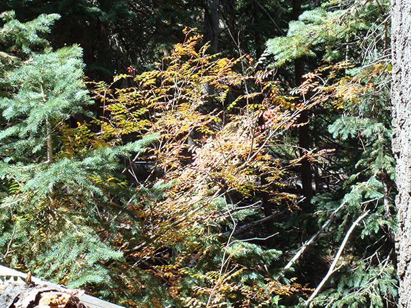 Autumn color. [photo by Ted] |

|

|
| Quaking aspens. [photos by Ted] | |
 Hikers take a break. [photo by Ted] |
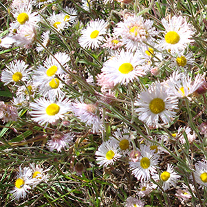 Fleabane. [photo by Ted] |
 Autumn color. [photo by Ted] |
 Autumn color. [photo by Ted] |
 Top of Page
Arizona Trailblazers Hiking Club, Phoenix, Arizona
Comments? Send them to the AZHC .
updated April 19, 2020