Outdoor Links
Hike Arizona
Trip Planning Guide
Trip Report Index
Calendar of Events
Library
Sedona
October 10-12, 2008
by Chuck Parsons
|
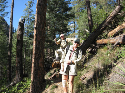
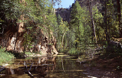
From our rocky vantage point high atop the East Rim of Oak Creek Canyon we have a commanding view looking up and down the canyon, in addition to a bird’s eye view of the West Rim of the canyon. The view comes at a price, however, with a steep 800-foot climb in less than a mile up rough and rocky Cookstove Trail as it claws its way up the rim in a tight series of narrow switchbacks. |
 Oak Creek Canyon from the East Rim [photo by Bill] |
|
From the 5,500-foot trailhead at the north end of Pine Flat East Campground, we top out on the rim at 6,300 feet with a cooling wind blasting across the canyon. |
|
About a quarter-mile up the trail we hear the unmistakable and sharp cracking sound of either a falling tree or a very large tree branch somewhere on the slope above us, followed minutes later by the same and all-too-familiar sound once again. We spot numerous dead standing and fallen trees along the trail, most probably victim of the infamous pine bark beetles ravaging their way across Arizona’s drought-stricken forests. |
 Pine Bark Beetles strike again! [photo by Bill] |
|
The large diagonal pine tree on the right side of this picture, now completely blocking the trail, was definitely not there earlier. Bill, Linda, Debbie, Karen, and I all agree to that and realize that it came crashing down just minutes after we went through here on our way up the trail. Bill and Linda have already made their way around the fallen giant as Chuck makes his way over the base of the tree lying across the trail. |
|
East-facing cliffs on the West Rim of Oak Creek Canyon high above our campground blaze with gold from the early morning rays of the rising sun. A somber gray sky above the rim looks like the precursor to a large storm system sweeping across the canyon on this cool fall morning in mid-October. We awaken to a brisk temperature of 40 degrees on our first morning at Pine Flat West Campground. |
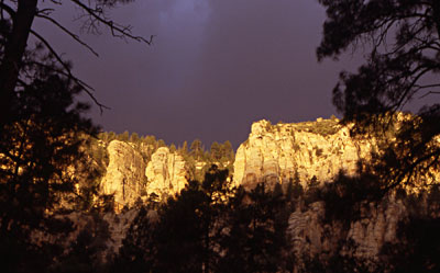 Sunrise over Oak Creek Canyon |
|
Sleep eluded most of us during the night as ferocious winds roared through the tree tops and upper canyon throughout most of the night. Occasional wind gusts also found their way down to the canyon floor during the night, shaking and flapping our tents as if to make sure that we didn’t sleep through the shrieking winds high overhead. |
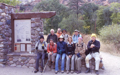 Hardy Trailblazers gather at the West Fork Trailhead |
Bundled against the chilly morning air, ten Arizona Trailblazers gather for a group picture next to the West Fork Trailhead sign. Seated, from left to right: Barry, Jenni, Debbie, Karen, Linda, and trip leader Chuck. Standing at back: Doug, Glenn, Ray, and Bill. Doug’s daughter, Michelle, will join us later in the day. |
|
Although still pretty cloudy, the threat of rain seems to have diminished for now. We have a six-mile round trip hike ahead of us, with a lot of things to see and do and we’re burning serious daylight. Let’s move ’em out, Barry! |
 Chuck and Bill hit the trail running [photo by Jenni]. |
Chuck and Bill check out something interesting in the distance. Most likely a deer or perhaps even Big Foot making a rare Arizona appearance. Brown and brittle bracken ferns in the foreground are testimony to the frigid nights that are now settling in the canyon. Just weeks earlier, they were lush green like the trees looming over them. But they start to brown out quickly with near-freezing temperatures. |
|
We hope those same cold temperatures are doing their magic to some of the trees deeper inside the canyon, particularly the colorful big-tooth maples. If the timing is right, the fall colors along the West Fork Trail are some of the most breathtaking to be found anywhere in Arizona. |
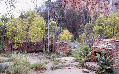 Ruins of the old Mayhew Lodge |
A few brick walls and part of the main fireplace are almost all that remains of the rustic old Mayhew Lodge that once stood steadfast watch over this part of the canyon. Farther up the trail is a shallow cave once used as a root cellar and an ancient chicken coop built into a second shallow cave. We also spot the crumbling concrete remnants of a long-abandoned swimming pool built right up against the canyon wall. |
|
Celebrities, from actor Clark Gable to novelist Zane Grey, were once frequent guests of the lodge during its heyday from the 1920s through the 1940s. Grey penned the words to his novel, The Call of the Canyon, here on the original cabin site that predated the lodge. Purchased by the U.S. Forest Service in 1969 as an historic landmark, the lodge later burned to the ground in 1980. “The red walls seemed to dream and wait under the blaze of sun; the heat lay like a blanket over the still foliage; the birds were quiet; only the murmuring stream broke the silence of the canyon. Never had Carley felt more the isolation and solitude of Oak Creek Canyon.” |
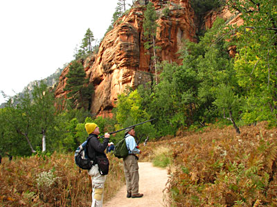
 Fly-casting for trout along the West Fork. 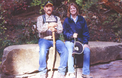 Ray and Debbie take a break from hiking. On any day during the summer and fall months, both professional photographers and wannabe professionals can be seen peering intently through the viewfinders of their expensive tripod-mounted cameras at any number of scenes straight out of Arizona Highways Magazine. Mother Nature provides the perfect place to take a load off in the form of a massive rock slab ideally suited for sitting. Ray and Debbie take advantage of the cool stone couch and pause for a short rest break along the West Fork Trail. This marks roughly the half-way point on our three-mile journey to the end of the trail, where its terra-firma segment terminates and the aquatic segment begins. |
|
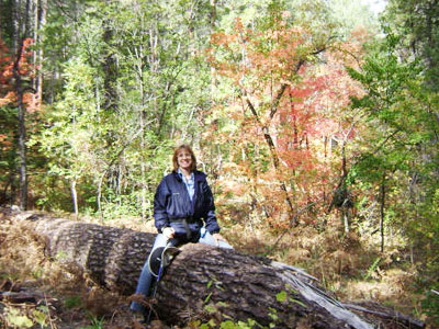
The old adage “it’s not the destination that matters nearly so much as the journey that takes us there” is certainly an accurate and fitting tribute to the West Fork Trail. And that can only be fully understood and appreciated by actually taking the time to hike the full length of this magnificent trail through the Red Rock Secret Mountain Wilderness. Timing the exact peak for fall colors is almost as difficult as trying to time the stock market. In the event of a heavy windstorm or a downpour, one day on either side of the peak can make all the difference between spectacular and so-so. As it turns out, we are about two weeks away from the peak fall colors along the West Fork Trail. However, we’re still fortunate enough to see more than a few of these bigtooth maples that are certainly colorful enough, although still not quite at the peak of their bright crimson red fall colors. |
 Bigtooth Maple nearing its prime |
 Ride ’em Cowgirl! [photo by Ray S] |
Alas, our resident cowgirl, Debbie, is still in search of a real flesh and blood horse that she can ride like the wind. Unfortunately, saddles and horseflesh seem to be in short supply along the trail today, so she happily settles for the nearest big log to ride instead. Not quite the same thing, but I guess it will have to do in a pinch. On the plus side, you don’t need to feed a log or find a vet for a sick log, and logs don’t leave large deposits along the trail. |
|
So there really are a few advantages to riding a log. Don’t you agree, Debbie? Hello?? |
 E.T.?? Are you there?? [photo by Debbie] |
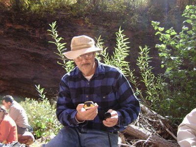
Glenn takes a reading with his trusty GPS to get his bearings and determine our exact position in the canyon. When hiking in deep canyons with a limited view of the sky, acquiring the necessary number of overhead satellites for the most accurate coordinates can sometimes be a challenge. Satisfied that we are not lost after all, Glenn gives a quick thumbs-up and we are off and running once again. |
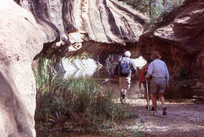
 Fording the West Fork |
The West Fork Trail traverses the West Fork of Oak Creek numerous times along its three-mile length, and each crossing seems to be more spectacular than the last. When the water surface is calm and perfectly still like this crossing, the resulting reflections from the surrounding canyon walls and trees can transform an ordinary scene into an extraordinary scene. |
|
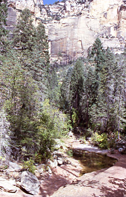
Towering canyon walls of cream-colored Coconino Sandstone reach out to caress blue Arizona skies as we approach trail’s end. As we penetrate deeper into the canyon, the canyon walls and cliffs seem to soar even higher and the canyon itself appears to slowly recede into infinity. At several points along the last mile or so of trail hikers are deceived into believing they are about to hit a dead-end box canyon with no way out but straight up, only to find that the trail continues on and on and on. But rest assured that it does eventually come to a stopping point, as seen in the following picture. |
 Nearing the end of the line. |
|
After three miles of steady hiking, we round one last bend and the West Fork Trail comes to an abrupt halt, literally dissolving into the creek bed. From here, hikers must resort to wading and even swimming across some of the deeper pools to proceed any farther. The waters of the West Fork are now forced to flow within the narrow confines of the upper canyon, which continues on for another ten miles from here. This spot marks the turn-around point for the vast majority of hikers and is a great place to stop, admire the views, and enjoy lunch among the boulders and trees. And that is precisely our plan as we stake out a place to sit down and enjoy a well-deserved lunch break before starting back. |
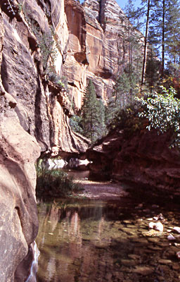 Where land ends and water begins |
 Open-air E.R. [photo by Jenni] |
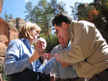
Just how many engineers does it take to remove a splinter? On a previous Oak Creek Canyon trip we had to ask the same question in regard to installing a rain shelter at the campground. The answer in both cases seems to be quite a few. At some point along the trail Debbie has picked up a small splinter in the palm of her left hand. We had attempted to remove it earlier with a pair of tweezers, but were not successful. This time a skilled trio of engineer/surgeons finally manages to extract the nasty little devil from her hand. |
|
Great job, Docs, and the patient even survived the operation! |
|
 Aquatic Hiking 101 |
Apparently, Doug, Jenni, and Karen have had just about enough hiking on dry land and decide to try their luck at walking on water. I don’t know, guys, the water seems awfully cold to me. I wonder if you can get frostbite from ice-cold water? Probably not, but you could start turning blue from the cold. Several other hikers had returned from hiking in the water earlier and reported that it was too cold to continue. |
|
Nevertheless, our intrepid trio decides to give it a shot anyway. Actually, I would have joined them myself had I brought along a pair of sandals. We didn’t have to wait too long for them to return and acknowledge that the other hikers weren’t exaggerating after all. |
|
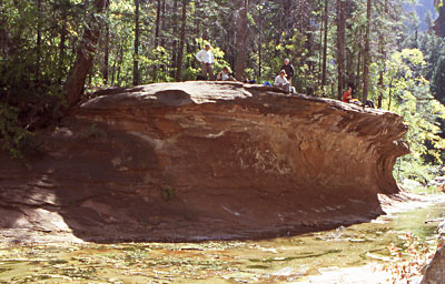 Surveying the scene from high atop the West Fork |
This high rock shelf serves as one of the best places in the canyon to take a leisurely break, watch the West Fork flowing lazily by below, catch a cooling breeze, or just enjoy the terrific scenery all around. The eroded and under-cut face of this rock shelf is stark evidence of the occasional flash floods that blast through the canyon after heavy spring runoffs or torrential up-stream summer monsoon rains. |
|
A creek that you can normally wade across with ease can quickly morph into a raging torrent of muddy water up to ten or fifteen feet deep. |
|
Doug points to Karen’s upended tent, which we discover on our return from the West Fork Trail hike on Saturday afternoon. Although we did not encounter any strong winds on the hike, apparently there were some wind gusts in the campground strong enough to knock over this tent. Fortunately, none of our other tents suffered the same consequences. With a little help, Karen manages to put her tent in the upright position, where it remained for the rest of the trip. |
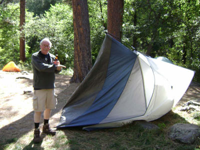 Houston, we have a problem [photo by Debbie] |
|
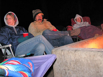
Ray, Glenn, and Chuck sit around the campfire after Saturday’s hike, trying to keep warm with the persistent cold winds blowing through the canyon and our campground. The colorful blanket and thick socks belong to Barry, unseen in the foreground. On previous Oak Creek Canyon camping trips we’re usually trying to cool off after the day’s hike, changing out of sweat-soaked T-shirts and splashing cold water on our sweaty and dirt-streaked faces. |
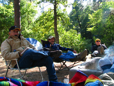 Post-hike warmup [photo by Jenni] |
|
This trip seems to have something entirely different in store for us. |
|
|
Barry is taking no chances as the sun all-too-quickly descends toward the western rim of Oak Creek Canyon and the wind-chill continues to be a serious factor in the comfort equation. When the sun dips below the rim this time of year, the temperature in the canyon starts to drop quickly and additional layers of clothing and another log or two on the fire are needed to stay warm. We are curious, though, about the blue insulating jacket wrapped around Barry’s bottle of beer. |
 Barry bundles against the oncoming blizzard [photo by Jenni] |
|
Is it there to keep the beverage cold, or is it there to keep Barry’s drinking hand from getting any colder? Just one of life’s many unexplained mysteries, I suppose. |
 Campfire Camaraderie. [photo by Jenni]  The perfect campfire! [photo by Jenni] When Debbie broke up the ice in the container and poured out some water into a small glass to brush her teeth, the water in her glass froze over within seconds and she had instant ice crystals on her toothbrush. Only the very dry air kept the campground and our vehicles from being draped with a heavy layer of frost. B’rrrr!! Double b’rrrr!! Now, the unseasonably warm mid-90s back in the Phoenix area doesn’t seem so bad after all. |
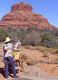 Photographer meets Artist |
 Second view of Bell Rock |
|
In a sort of meeting of the mediums, the camera and the canvas both attempt to capture the essence and the timeless beauty of Bell Rock, probably the most famous and recognizable of the Sedona area’s many spectacular and colorful rock formations. Bell Rock stands silent and eternal watch over the Village of Oak Creek, the south gateway to Sedona’s famous Red Rock Country. |
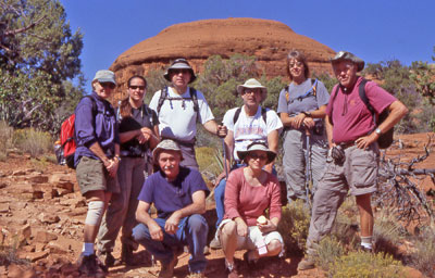 On the Bell Rock/Courthouse Butte Loop Trail |
With hike leader Chuck behind the camera lens, Linda, Jenni, Barry, Glenn, Karen, and Bill, with Doug and Michelle kneeling in the foreground, pause in front of Spaceship Rock. At least that’s what we jokingly call this large dome-shaped formation that looks as if it could lift off from its rocky base and head out into space at any moment. |
|
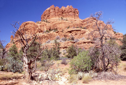
At this point, we are roughly a third of our way through the 4.3-mile circumference trail that goes around the base of Bell Rock and Courthouse Butte (still often referred to as Cathedral Rock). With towering red rock cliffs serving as an imposing backdrop, Arizona Trailblazers descend a dry rocky trail as we continue making our way around mammoth Courthouse Butte, unseen to the left of the picture. |
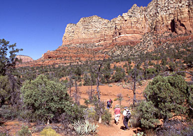 Trailblazers blaze their way down the trail. |
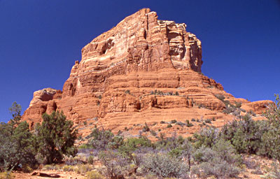 East side of Courthouse Butte 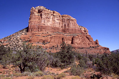 Parting Shot |
Courthouse Butte takes up such a large chunk of real estate that it takes a bit of time and effort to hike your way all the way around the base. After finally making our way past the long south side on our counter-clockwise hike around the loop trail, we are greeted with this magnificent view of the east end of the butte. The Red Rock Country surrounding Sedona and the Village of Oak Creek is a true photographer’s paradise with an infinite number of photo opportunities. For an avid landscape photographer, it is always a challenge trying to find the best vantage point, the overall best prospective, a natural setting free of people, and finally to do it all under the most dramatic lighting conditions possible. |
|
The typical day hiker-photographer, especially when hiking with a large group of people and under time constraints, often has to compromise and settle for less than optimum conditions and make the best of the situation at hand. |
 Top of Page
Arizona Trailblazers Hiking Club, Phoenix, Arizona
Comments? Send them to the AZHC .
updated March 15, 2018