Outdoor Links
Hike Arizona
Trip Planning Guide
Trip Report Index
Calendar of Events
Library
Sedona
April 18, 2009
by Chuck Parsons
 Aftermath of the Brins Fire |
|
Hundreds of blackened trees along the Vultee Arch Trail, many still standing, remind us of the constant danger and threat of forest fires throughout Arizona. |
 Ponderosa pine burned to charcoal. |
The Brins Fire of June, 2006, torched over 5,000 acres of prime forest in the Red Rock Country around Sedona, including the Vultee Arch and Devil’s Bridge areas, Brins Mesa, and North Wilson Mountain. An unattended campfire and a gust of wind is all it took to start a major conflagration. The charred remains of this huge ponderosa pine are testimony to the extreme intensity of the Brins Fire. There’s a lot of wood in a tree this size, and virtually every fiber of it all the way down to the tree’s center core was burned completely to charcoal. With all of its mass consumed, this tree won’t be returning any of its nutrients to the forest floor. Hundreds of the towering pine trees that once provided abundant shade for hikers along the Vultee Arch Trail are now gone — victims of human carelessness. |
|
After hiking for 1.6 miles along the floor of Sterling Canyon through a mix of burned and untouched areas, the trail breaks out into a clearing and climbs up onto a massive red rock ledge, or bench in geological terms. |
|
Vultee Arch lies about a 100 yards away at the north end of this box canyon. It would require some serious bushwhacking to reach the base of the arch, so we settle on the great views from our grandstand bench seat. Glenn, Kathy, her canine companion Butch, and I stop here for a rest and lunch break before returning on the same trail. |
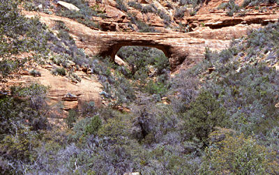 Vultee Arch at last! |
 Dedication Plaque |
Caught up in an unexpected snow storm on a freezing January night in 1938, aviation pioneer and head of Vultee Aircraft Corporation, Gerard Vultee, along with his wife, Sylvia, lost control of his personal Stinson aircraft and crashed in an area known as East Pocket, about one mile north of this bare redrock bench that now bears a large bronze plaque commemorating the two. |
|
Named after the Vultees, who were both killed instantly in the 1938 crash, Vultee Arch stands like a massive lone sentinel against the far north wall of Sterling Canyon, as if guarding the crash site against all intruders. |
|
This spectacular formation sits high atop the massive rock bench we're using as our lunch and rest stop. Looking somewhat like its larger cousin, Bell Rock, this unnamed formation overlooks Vultee Arch, Sterling Canyon, and surrounding red rock country. |
 Red rock formation overlooking Vultee Arch |
 Honanki Ruins |
Anywhere else in the USA, the area surrounding Sedona would be preserved and enshrined as a National Park. But due to a variety of circumstances, we can only grant it State Park or National Forest classification in Arizona. With luck and good planning, it will still be preserved for future generations to enjoy. After completing the Vultee Arch hike, Glenn and I decide to head over to the Honanki Ruins area. Kathy and Butch have left for Phoenix. Generally regarded as the most well-preserved Indian ruins in the Sedona area, Honanki Heritage Site occupies a large cave at the base of Loy Butte. An easy quarter-mile trail provides close access to the ruins. |
|
The Sinagua Indians, ancestors of modern-day Hopis, occupied this area for about 200 years from 1100 AD to 1300 AD before vanishing from the site. The many petroglyphs, or rock art drawings, they left behind on the walls and ceilings of the rooms here serve as a record of their time in the area. |
 Parting view of Honanki Ruins |
 Top of Page
Arizona Trailblazers Hiking Club, Phoenix, Arizona
Comments? Send them to the AZHC .
updated July 29, 2020