Outdoor Links
Hike Arizona
Trip Planning Guide
Trip Report Index
Calendar of Events
Library
|
First Water to Canyon Lake Day Hike Superstition Wilderness March 13, 2010 by Bill Zimmermann |
|
 Eighteen enlightened Trailblazers at Boulder Canyon [Photo by Bill] |
|
We had great weather as 18 Trailblazers assembled in east Mesa and traded cars for this one-way key exchange hike. Ten went south from Canyon Lake led by Bill, while the other eight started from the First Water horse staging area with Ted leading. The southbound hike begins with a 625' climb to the top of hill 2351. Our first view of Weaver’s Needle is less than a mile from the trailhead. |
 Trailblazers visit the Indian Paint Mine. [Photo by Bill] |
|
“Wet feet are possible,” the hike description said. No one doubted that as we crossed LaBarge Creek on our way to the Indian Paint Mine. The mine is near a saddle between LaBarge Creek and Boulder Creek. Hikers take time to explore it and enjoy the bright, colorful rock formations. Another creek crossing gets us on our way to the junction where Second Water Canyon flows into Boulder Canyon. |
 Can you get across Boulder Creek with shoes dry? [Photo by Bill] |
 Champaign, Bill, or just Bubble_Up? [photo by Wendy] |
Here we find an outstanding picnic area with great views of Geronimo Head and nearby Battleship Mountain. Jenni is the first to arrive from the northbound group. Soon everyone is relaxing on the rocks and enjoying a picnic lunch on a beautiful day. Ajay crosses the creek to take pictures of the group, while Bill has everyone line up by the water’s edge. After lunch the groups divide and we start upstream along Second Water Creek toward Garden Valley. |
|
After the recent rains, Second Water Canyon looks more like an oasis than a desert. Pools of water are teeming with algae. Green vegetation contrasts the boulders that washed down from Black Mesa millions of years ago. Our 480' climb to Garden Valley is stretched out over two miles as we pass the Cholla Tank Trail and the place where we joined the Second Water Trail on last year’s Black Mesa hike. Rocks and dirt on the trail give way to irregular black cobblestones as we walk by Hackberry Mesa. Finally we enter the east side of Garden Valley near a livestock watering tank left over from ranching days. The tank, which was dry and cracked last time, is full of brown water. |
 Second Water Canyon. [photo by Wendy] |

|

|
| Fiddleheads on prickly pear, and a blaze of glory. [photos by Wendy] | |
 The horse trail in Garden Valley is full of mud. [Photo by Bill] |
We decide to bypass Hackberry Spring based on the advice of the northbound group. So, just before the junction with the Black Mesa Trail, we turn right and follow an unmapped but well-worn trail to the north end of Garden Valley and beyond. The dashed contours on the map of Garden Valley are depression contours. |
 Guess who. [Photo by Bill] |
Water can’t drain out of Garden Valley, which usually doesn’t matter because it’s in the Sonoran Desert. But today it does. How big a detour do we have to make to keep from sinking in the mud? A wide semi-circle around the depression might have saved us, but not quite. We leave Garden Valley and contour a scenic canyon to a junction where three trails meet. |
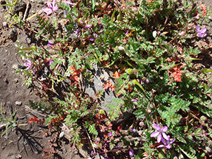
 Erodium cicutarium – Redstem Stork’s Bill. [photo by Wendy] |
We turn left. From the junction it’s an easy walk down to the windmill and over to the First Water horse staging area, where our cars are waiting. Thanks to all, and hope you had a fun hike! Bill’s GPS said 9.01 miles, +1967'-1566'. |
|
Supplemental Report by Ted Tenny |
|
|
Eight northbound hikers start from the First Water Horse Staging Area. There’s a trail that goes down to First Water Creek, where we hoped to find the water low enough to make the seven crossings on the Hackberry Spring route. Well, maybe next time. After looking at the rushing water we decide to head upstream to join the Second Water Trail to Garden Valley. Our streamside trail isn’t on the map. It takes us by the windmill, along First Water Creek and then across, where we join the Second Water Trail near the site of the ranch. After having the wilderness to ourselves we start meeting many hikers and campers. |
 Northbound hikers on the Second Water Trail  Splash! We made it over most of those rocks. [Photo by Wendy] |
|
|
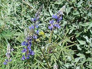
| Lupine and Redstem brighten the Second Water Trail. [photos by Ted] | |
 Perfect Picnic spot! Now let’s do a group picture. [photo by Ajay] |
|
We join the southbound hikers at Boulder Canyon for lunch and the all-important car key exchange. Just as we’re starting up the Boulder Canyon Trail we hear the buzz of a rattlesnake. It’s right beside the trail, and not about to give an inch. So everyone takes a detour around the snake while snapping away with cameras. |
 The Boulder Canyon Trail belongs to me! [Photo by Ajay] |
|
Splash! Ted’s flying leap almost gets him over the wet cobblestones in Boulder Creek. He’s all right but his camera got dunked. [It was later restored to health by a treatment with his wife’s hair dryer.] By the time we get to LaBarge Creek everyone has given up the idea of keeping their feet dry. But the day is warm and this will be our last water crossing. |
 Who cares if we get our feet wet? [Photo by Wendy] |
|
There’s a big climb ahead. “Take it at your own pace,” Ted advises as we begin our ascent to a famous Weaver’s Needle overlook. Geronimo Head, Battleship Mountain, Black Mesa, Hackberry Mesa, and LaBarge Canyon round out our panorama of the Superstition Wilderness. To the north is our first view of Canyon Lake. |
 Bright colors of Paint Mine Saddle cheer us. [Photo by Wendy] |
 Civilization at last! We made it to Canyon Lake. [Photo by Ajay] |
From here the Boulder Canyon Trail takes us to the top of hill 2351. Along the way we enjoy spring flowers and rocks frosted with a thin layer of quartz. At the top of the hill the trail splits into a direct descent to Boulder Canyon Trailhead or a winding route to one last Weaver’s Needle view. We take the direct route to finish a lovely day’s hike. |
 Top of Page
Arizona Trailblazers Hiking Club, Phoenix, Arizona
Comments? Send them to the AZHC .
updated November 18, 2019