Outdoor Links
Hike Arizona
Trip Planning Guide
Trip Report Index
Calendar of Events
Library
|
North Goldfield Skyline Day Hike Goldfield Mountains November 20, 2010 by Ted Tenny |
|
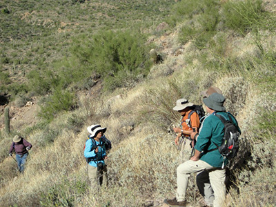
 Trailblazers explore the high country of the Goldfields. |
| Ajay, Chip, George, Quy, Gary, Steve, Ted |
|
What might have been an ordinary hike turned into a wild and wooly adventure when we decided to start from Water Users’ Trailhead instead of Blue Point. |
 O.K., Ted, now take one more step. [photo by Ajay]  George and Gary complete the river crossing. [photo by Chip] Nice try. When we got down to the river, it was full of moss that slickened the stepping stones and hid the river bottom on the south side, so you couldn’t see how deep the water was or what may have been under the moss. Somebody had to be the first one across. So after I stepped ever so carefully to the last cobblestone, I took took one more step into the moss. Splash! The water was almost knee-deep. By then my boots and socks were soaked, so I figured, why not go ahead and wade the rest of the way across. This left a wet-footed hike leader on the south side of the river, with everyone else on the north side trying to figure out how to get over. Worse, I had the keys to the only car at the trailhead, so they couldn’t drive back to Blue Point unless we somehow got my keys over to the north side of the river. I’m not throwing them! Eventually they each decided to wade, some taking their shoes and socks off and others just splashing in. |
 Bajadas look smooth – until you hike across. [photo by Chip] There are many horse trails. The main one going east and west gave us a fine view of the Sunrise Arch, so called because the sun shines through it briefly on early summer mornings. It’s all shaded the rest of the year, and easy to overlook because you can’t see the sky through it from the river. The Sunrise Arch is a natural bridge, evident from the vegetation growing where water flows beneath it. Now where’s that horse trail going south? We found one, very faint but with horses there recently – hold your nose. It took us south above a steep wash, then faded out, then re-appeared mysteriously. Thus began a mile of mostly bushwhacking with a few game trails thrown in. There were numerous rocky washes to either cross or go around. |
 Fantastic rock formations decorate the Gateway Canyon Trail. |
|
Finally we re-convened on the Gateway Canyon Trail, well above the junction with Rhyodacite Canyon. Everyone breathed a sigh of relief that we were on a real trail, at last. The trail is very steep and rocky, marked with cairns, always on the north side of the canyon and high above it in places. We persevered and found ourselves in the high country of the Goldfields, most of us for the first time. From the top we visited some scenic overlooks and stopped for lunch at a panoramic view of Gateway Canyon, the Salt River, various peaks of the western Goldfields, and the Valley of the Sun. |
 Ocotillo and Teddy Bear cholla accentuate the Four Peaks. |
 Conglomerates tell of Miocene volcanism. |
 Each color of lichen is a different species. |
 Glad we weren’t there when those rocks tumbled.  Gateway Canyon stays rough below the junction.  Autumn color graces the Salt River. [photo by Ajay] |
By this time it was clouding up. We exchanged stories about getting caught in the rain on hikes, then realized that we wouldn’t want to be up here if a storm blew in. So we started down. “Re-convene when you get to the big rockfall,” I advised them. The rocks, many of them as big as trucks or houses, evidently broke off the cliff all at once and went crashing down into the valley below. The rockfall is clearly visible in satellite photos of the northern Goldfields. No one knows when it happened but it looks like only yesterday – geologically speaking. By Rhyodacite Canyon the routes divide, with one trail going north to the Salt River and the other going west. No one wants to wade the river again, so we decide to walk to Blue Point Trailhead, where most of the cars are parked. We continue westward on the lower half of the Gateway Canyon Trail. The trail is a pure delight! It follows a smooth ridge with lower Gateway Canyon on the left and a friendly wash on the right. Although faint in places, the trail now continues all the way down into the wash, which gives us a smooth, sandy walk to the river country. A short walk through the woods brings us to a Jeep trail lined with cobblestones. |
|
From here to Bulldog Canyon there are various Jeep trails, horse trails, and walks along the river bank. The key to success is to stay close to the river, even when you are tempted to turn south. A lawman on horseback greets us as we cross 3192 Canyon and proceed westward to Bulldog Canyon. From here there are many ways to get to Blue Point Trailhead, with a confusing maze of trails and roads. The group divides. Quy and I must have found the shortest way, because we are the first to arrive even though the others walk faster. Everyone agrees it was a "B" hike. Steve left some equipment in my car, so he gives me a ride back to Water Users’ Trailhead. |
 Top of Page
Arizona Trailblazers Hiking Club, Phoenix, Arizona
Comments? Send them to the AZHC .
updated December 21, 2019