Outdoor Links
Hike Arizona
Trip Planning Guide
Trip Report Index
Calendar of Events
Library
Picacho Peak State Park
May 16, 1998
by Jeff Cook
|
Despite its rather uninteresting location beside I-10 just South of Casa Grande, the Hunter Trail leading to the highest point on Picacho Peak is easily the most interesting – and most fun – trail I have yet hiked. This is attributable to two things. First is the fact that the peak is visually striking; it is a steep-sloped, solitary ridge, nearly two miles long altogether, capped by a pair of 600-foot- high wedges of basalt with sheer cliffs on all sides. The second thing that makes it such a great hike is that it is not a trail for sissies; it covers a wider variety of terrain than most, including some short but impressive cable-assisted pitches up nearly vertical rock faces. |
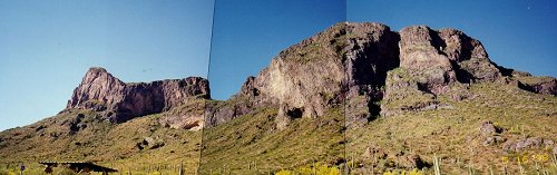 Picacho Peak, from the trailhead. |
|
The trail begins in the park’s Barrett Loop, at an elevation of about 2000 feet. Its official length is 2.0 miles one way, though the sign near the trailhead says 2.1. The trail ends atop the highest point on the formation, at 3370 feet, but the total vertical climb is much greater than 1370 feet due to a substantial down- slope segment on the far side of the ridge. Our group was just four in number, but that did simplify the transportation arrangements considerably. We arrived at the trailhead at about a quarter past eight in the morning, with bright sun, a light breeze, and temperatures approaching a refreshing 70°. There were a few other cars in the lot, unfortunately including several suburbans packed with about 30 high-school teens. They were kind enough to let us pass, though, and we soon left them far enough behind that we could neither see nor hear them. The trail switchbacks up the 40° flanks of the ridge for the first 3/4-mile or so. There is some slippery debris and gravel on the moderately steep trail, but for the most part it is well packed. There are also a number of places where the trail seems to split into two trails, but generally, unless otherwise marked, one of these is just a trail of use or shortcut, which soon joins back with the real trail. Along the way we shared the trail with countless busy black beetles, about an inch long with bright red head and thorax, and which seemed just barely able to hold themselves in the air when they saw fit to leave the warmth of the ground. For a while, the switchbacks lie on one side of what appears to be an old elevated roadbed, most likely from an old mine car track, climbing straight up the side of the ridge for several hundred yards before disappearing into the chaparral. After about a 600-foot gain in elevation, the trail reaches the bottom of a vertical rock face. It skirts around it to the southeast, then climbs up onto it and onto one end of the saddle (2980 feet) between the two main sheer-walled peaks. There is a bench here on which to rest; we did just that, though thanks to the slow, steady pace we set, not much of a break was needed. Continuing on the other side of the saddle, the trail immediately plunges 200 feet down the vertical side of the larger and taller southeast peak at about a 45° angle. There are cables on one or both sides the whole way, and at one point, the trail is so steeply tilted that only the most hardheaded scrambler could squeeze by without using the cables. Where there are two cables, they are well situated for quick descent by the slide-and-hop technique, sliding the hands forward a few feet and then hopping down the slope six feet at a time. There is really no exposure here, except for the imposing descent straight ahead. The total descent on this leg is about 460 feet. After a brief level section with excellent views of the plain and mountains to the south, the trail turns sharply upsweep, and the real fun begins. The trail climbs up a series of short (10 to 30 foot) rock pitches, some approaching 80° in slope, and some smooth enough to make footing a bit tricky. All of them are equipped with thick cables on both sides, with multiple cables or wire fencing where appropriate to absolutely minimize the risk of falling. As a result, the exposure was not nearly what I had gathered from descriptions of the hike, and in fact I’d say exposure is not at all a concern anywhere unless you have a particularly severe aversion to heights. Nevertheless, negotiating the steep climbs requires a fair amount of hand and upper body strength, and great care must be taken in both ascending and descending. The views on this part of the peak are tremendous – not so much the surroundings, but the heights, angles, and textures of the weathered cliff faces themselves. At about the 1-1/2 mile point, the trail again levels out at about 2900 feet in a spectacular half-bowl shaped amphitheater, about 200 feet across and roughly as deep, and opening out into the cliff on the south side of the peak. The trail circles about 3/4 of the way around the feature, then climbs up the east side in the most difficult pitch of the hike, a 25-foot scramble up a smooth, nearly vertical crack in the basalt. The trail then winds briefly along a narrow ledge, which is slanted so severely at one point that a narrow, 15-foot metal-framed wood plank bridge was installed to make the route passable. No choice but to put all your confidence in the wobbly-framed cables here! |
 The view from the top. |
|
Finally the trail is up on the sloped top of the peak, and except for a couple of steep spots, the last 200 vertical feet are an easy uphill walk. The trail passes through a narrow band of conglomerate, a curious streak of sedimentary rock in the otherwise monolithic basalt. The summit is relatively flat, and about ten by twenty yards in size. The view is an almost unobstructed 360°, since it’s a 600-foot drop straight down on most sides, with yet another remarkable angle of the northwestern peak and the ridge below. We made ourselves comfortable, had lunch and those of us who had ‘em changed to a fresh pair of socks. The temperature was still comfortable at around 80°; it had taken two hours to go two miles. The insects up top were pretty fierce, but they generally left us alone except for the houseflies. After 15 minutes, the now rather strung-out group of high-schoolers began arriving on top en masse; as passing is difficult at best on the upper mile, we waited until they had all arrived, then began our descent. We took a quick detour over to the western edge of the peak (3210 feet) along the way; a light but obvious path the whole 300 yards made it an irresistible detour. It was worth the view, but as a result we also wound up behind the same group of teens again. We therefore had to wait in line at the first few steep spots, but once the trail leveled out again, the energetic youngsters were off like a shot, and we didn’t see them again the whole way down. The last 3/4-mile was somewhat warm, as we were back on the 40° incline of the lower north slope, and no longer enjoyed the copious shade cast by the vertical walls and overhanging masses of the peak. The temperature had risen to the upper 80s, as well. But we all had plenty of water and energy left, and the rest of the descent was easy and uneventful. Total time for descent was about an hour and a half. We got back into the car, and headed under the I-10 overpass to visit the Dairy Queen someone had thoughtfully built there for our indulgence. I was surprised to find this hike very physical, yet almost easy, despite the total vertical climb (including the 460-foot climb over the saddle on the descent) of 2300 feet. In part, I attribute this to the slow pace we kept. On Quartz Peak, I had pushed myself to keep up with a fast group going both up and down, and wound up absolutely wasted. On this occasion, I was able to keep my heart beat in the aerobic 120-140 range the whole way, and it made a huge difference. This was a valuable lesson for future hikes: never push to keep up. If the group won’t wait then let them go and enjoy the hike in solitude at your own pace. The cool temperatures and ample shade were also a great help, as was the fact that the trail includes a wide variety of terrain and is well-mixed, allowing the use of alternating muscle groups while resting the others for the next section. I strongly recommend this hike to everyone who can handle a moderate upper body workout. It’s an hour and a half’s drive, but I hope to return as soon as the opportunity presents itself. |
 Top of Page
Arizona Trailblazers Hiking Club, Phoenix, Arizona
Comments? Send them to the AZHC .
updated August 3, 2019