Outdoor Links
Hike Arizona
Trip Planning Guide
Trip Report Index
Calendar of Events
Library
|
Grand Canyon Day Hike Grand Canyon National Park October 5, 2000 by Mike Wargel |
|
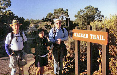
 Chuck, Tom, Angie, Mike |
Tom and Jeannie Van Lew, their son Jason and his girlfriend Holly, Chuck Parsons, Angie Lien, and I headed up to Mather Campground on Friday afternoon. Upon arriving at the Campground, we noticed a rather slow moving check in line (Tip for future travelers, get there early!). Slow enough to allow the Van Lews (who left nearly an hour after us) to catch up!! Being in the lead vehicle, we were able to have them waived through and quickly get to our campsites. The weather was spectacular to say the least. Nice and cool with clear skies and fresh air. The forecast called for warmer than usual temps with highs in the 70s on the rim, 90s at the river. Tom and Jeannie were anxious to test out all the features of their new cab-over camper. |

Our route would take us down the Kaibab trail, past Cedar Ridge, to the Tip Off point. From there, we would take the Tonto trail 4.6 miles to the Bright Angel trail. After a rest stop at Indian Garden, we’d head out to Plateau Point (3 mi RT), then out the Bright Angel trail. Total distance of 17 miles. Yes, in one day. We headed back to our campsites for a potluck BBQ and early bed for the upcoming hike, later named "Death March 2000" on Saturday. Saturday morning at 7am, Jeannie shuttled Tom, Chuck, Angie, and me to the road leading to Yaki Point. From there, we walked the short distance to the trail head. Despite the barricades and signs, people were still driving through and out to the lookout point and the trailhead!! (And they wonder why the park wants a shuttle service!) A quick picture at the trailhead, shuffling of clothing layers, allowing a couple of larger, faster groups to pass ahead, and off we were at 7:30. The Kaibab trail is the most popular way to go IN to the Canyon as it drops very quickly down in. The elevation at the South Rim is 7262ft. Within an hour, we had made it to our first stop, Cedar Ridge. Down 1100 ft from the rim, Cedar Ridge is named for the red colored rock, similar to what you find in Sedona. Above, we could easily see the limestone layer composing the top layer of rock. After a brief stop and shedding of first layer (hat and sweatshirt), off we went down further to O’Neill Butte. |
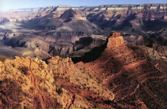 O’Neill Butte glistens in the morning sun. |
|
This portion of the trail is easily viewed from the lookout at Yaki Point. The trail heads out to O’Neill Butte, then along it’s eastern face before dropping down several steep switchbacks, out of view of Yaki Point. Just as we started down the switchbacks at Skeleton Point, we caught our first glimpse (albeit a narrow one) of the Colorado River, down 2040 ft from the Rim. From here, we could also see the next leg of our trip, the Tonto Trail. |
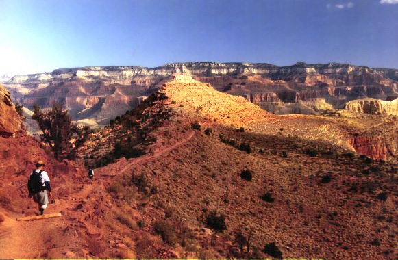 This part of the South Kaibab Trail slopes gently. |
|
Along the way, we conversed with a pair of ladies who appeared to be unsure as to how far down, or where they were going. Their friends were going to the river and back out. One in tennis shoes. We had also spoken with a solo lady backpacker who had hiked only to Cedar Ridge in the past and wanted to follow our route to Indian Garden. After hiking down the switchbacks, we ran into two groups of mule riders on their way out. Some people just have to take the easy way eh? 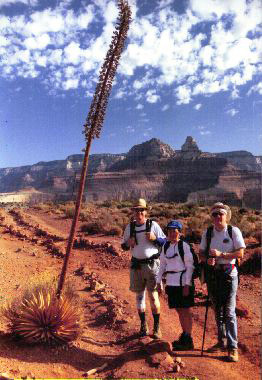
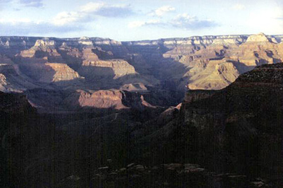
The trail goes down very quickly again. So much so that we are practically running down the trail. Tom’s map indicated the window in the rock, and sure enough, there it was above to our left!! The trail goes around the eastern and northern sides of O’Neill Butte before heading out to the Tip Off and the intersection of the Tonto Trail. A brief stop at the rest rooms, snack, and visiting with a German couple that had been camping and backpacking along the Tonto Trail to the east near Lipan Point we collected at the trail junction for a photo op, courtesy of our friendly pair of hikers. Chuck and I, being avid photogs, stopped shortly after the junction to admire the view and reload film. A few moments later, we were greeted with our first view of the Inner Gorge of the Grand Canyon. From here, we could easily see Vishnu Temple, Wotans Throne, and on the north side, the Bright Angel Canyon. Looking down, we could easily see the Phantom Ranch area. Using binoculars, Chuck and I could see the individual buildings and paths around Phantom Ranch. 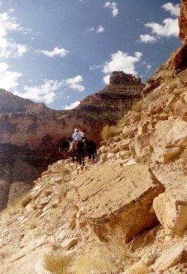
We continued along, snapping pictures, as Tom and Angie continued ahead. A short time later, Tom radioed that we’d better get along as we had a lot more trail to cover. The trail continued west for only a short distance before turning south into a side canyon. Tom’s topo map came in quite handy as we crossed Burro Spring and eventually to a perennial spring, Pipe Spring. We stopped to cool off in the terrific shade and cool springs. From here we could see wind caves, ferns, and many other items one would not expect to see in a desert canyon. As we headed out, we ran into our first encounter with other humans on this trail (the first two of only 3!!). A couple that were heading towards the Kaibab trail, and possibly on their way out. We continued north, noticing how the Inner Gorge canyon really juts into the South Rim area. Had the side canyon not been there, and the Tonto Trail run due east to west, we would have saved nearly 2 miles! From the rim, this level (at 3200 ft down from the Rim) looks as though the ground slopes down to the Tonto Plateau. Those slopes are really upwards of 100ft tall and the trail goes up and over several of them. At some points, the trail narrows to a mere foot path and the ground slopes down, with the Inner Gorge (and a 500ft drop) within inches! Not for the timid or height weary! 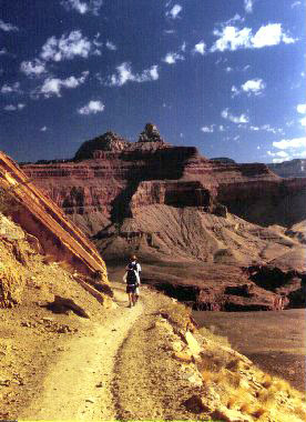
It’s now around 11am. Temps seem quite hot with lots of sunshine with only a few clouds overhead. A quick check of Chuck’s thermometer reads 105F!! So much for an accurate forecast!! The trail continues on a NW course before heading west, around to the eastern side of Bright Angel canyon. The trail maintains its pattern of up and down over large hills, narrow foot path, and intimidating slopes into the Inner Gorge. Still, I can’t imagine how, with this incredible view of Nature’s beauty and awesome power, we encounter only one other person on this leg of the trail! Very quiet as we hear the first and only plane flying overhead. The trail continues west, under the power lines running down to Phantom Ranch before heading SW to the junction with the Bright Angel trail. As we approach, we can see the trail out to Plateau Point on the other side and the Bright Angel trail sloping up to meet us, both seemingly bustling with activity. I encountered a pair of ladies, part of a larger group, heading up the Bright Angel trail, into Indian Garden. As the one accidentally dropped her walkman, I asked if they had hiked up from the river. She said “farther”. “The north rim? ? ”, I asked. She nodded yes. |
 Indian Garden can’t be far from here. |
|
A few minutes later, we pulled into Indian Garden with its mule stables, water, toilets, campground, all in the heart of the Bright Angel canyon. Time for lunch!! We rested for about 45 minutes, filling our nearly empty water packs, cooling off with the refreshing water. We encountered a group of hikers that had gone down the Kaibab to the River, dipped their feet, and headed up to Indian Garden on the Bright Angel trail, in the same time we had gone our route! We also saw others coming in from the North Rim. I’m thinking, “...and I thought I was in good shape”, not! 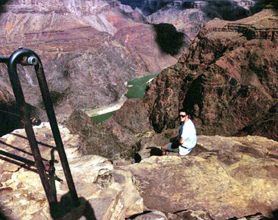
The heat had gotten to us. With temps in the 100 range, Tom, Angie and I headed out to Plateau Point, 1.5 miles out. This is the trail you can see from the rim that appears to go out to the Inner Gorge and stop. The sun was glaring down at this point. I was pretty tired from the heat and drenched in sweat, despite the amount of water I had already downed. We made it out to Plateau Point with it’s incredible views of the river, 2 sets of rapids, and the lower part of the Bright Angel trail some 1500 ft below, straight down! I asked Tom to take a quick pic of me with my feet over the edge (another one of my goals for the trip), snapped a few of the River, Inner Gorge, the rapids, and the North side of the Canyon before heading back to Indian Garden. |
 Cheops Pyramid and Isis Temple from Plateau Point. |
|
Chuck had started heading up, taking his time, as were the rest of us. The temp on the BIG thermometer at Indian Garden read 100F!! We filled up with water and headed up the trail. Knowing sunset was a scant 4 hours away and the Rim, our destination was 3100 ft up and 4.6 miles away I hadn’t realized how much the heat had gotten to me. I’ve hiked in 90+ weather before, but not like this. As we passed the campground, I could hardly see as the sweat came down in buckets. I could not drink enough water and it wasn’t coming out. Tom graciously offered some Gatorade and the approaching shade helped quite a bit. Next time, I’m bringing CytoMax along to mix on the trail!! |
 Yes, the panorama was worth the extra miles. |
|
As we started up the switchbacks, the sun had gone down over the rim enough to shade most of the Bright Angel canyon. We noticed all types of hikers along the way. One was even smoking a cigarette on his way down!! Some with very little water, others in jeans and tennis shoes, and the obvious tourists not acknowledging the demands of hiking in the canyon. I guess all the stronger hikers had already made it out or were camped out below. 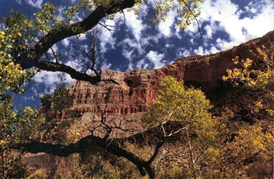
Needless to say, the trail is slow going at this point. Take several slow steps, stop. Repeat. Again, again. Again. We pass through the layers of rock, similar to what we saw on the Kaibab trail. We reach Chuck on the radio as he reached the 3 mile resthouse. Tom reached it a short time later, then Angie, then me. At this point, we managed to reach Jeannie (up on the rim at the Trail Overlook on the West Rim drive). She was surprised at how far we had yet to go. The rest of the way up, the TalkAbout radios allowed us to talk to Jeannie on the rim, with clear line of sight. Tom headed out with Angie, Chuck and I rested a bit longer as the heat’s effects had settled in. 
We knew the 1.5 mile resthouse was coming up but it still took almost two hours to reach. Taking several steps, rest, admire the view. Repeat. Again. Again. We could see the resthouse but after several more switchbacks only discovered we were still some distance away. Looking out into the Canyon, we could see sunset was approaching. Tom had made it to the top after running into some friends near the top. Angie was not too far behind as she also ran into some of her co-workers that had done a two day Rim-to-Rim-to-Rim trip. Chuck and I were moving along, albeit slowly as darkness descended upon the Canyon. I remembered what Tom had said about not looking up, it only gets you more depressed as the switchbacks take you back and forth across the canyon. Chuck had a flashlight, but its batteries were running low. We managed along with me a step ahead and Chuck shining his flashlight just ahead. The half moon rose above the rim and cast an awesome, but eerie glow over the limestone layer. Looking out into the dark abyss of the canyon, we could see a light at Indian Garden and the North Rim Lodge. Everything else was nearly black with only the brightest stars overhead. 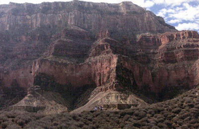
Even at this hour, we see people hiking DOWN into the canyon! We ran into a trio that had gone out along a deer trail to Battleship Rock, taking their time out. Jeannie had returned from the campground after dropping off Tom and Angie. By 8pm, Chuck and I made it out, tired, sore and glad to have made it out. After being driven back to the campground, a quick shower at the rest area, bandaging up the feet (Thanks Chuck for the First Aid kit!!), we were ready for dinner! Jeannie had made a wonderful pot of chili for everyone!! Tom, Angie, Jason, and Holly had retired for the evening by the time we got back from the showers. Chuck and I drank our favorite after-hike beverages and enjoyed some of Jeannie’s terrific chili before the rest of us retired. I think we had earned a good night’s rest. |
|
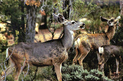
We awoke shortly after sunrise on Sunday. Enjoyed a relaxing and hearty breakfast. Tom had come over from his site followed shortly after by Jeannie, Jason, and Holly. We talked of the hike, the rather warm weather, the people we met along the way. We also shared injury and soreness stories. As on Friday, several deer made their way into the campground. |
|
The Van Lews then headed down to Flag to visit their daughter, Adrienne, in college at NAU. Chuck, Angie and I headed out on the shuttle to the West Rim. We saw the trail we ascended in the dark the night before, remarking “that’s where we were!” We took in tremendous views along several points before heading back to Angie’s truck for lunch and the drive back home. Being the great time of year, we stopped in Flag for shots of the Aspens changing colors too! |
|
This was the most challenging hike I had ever done, but still enjoyed every moment. It was a route I wanted to do for some time and I’m thankful for having been able to complete and even more so to have enjoyed with friends from the Hiking Club. I’m looking forward to 2001 when we can do a trip from the North Rim down and up to the South Rim, stay tuned! |
|
| For pictures, you’ll want to come to the November Hiking Club meeting!! | |
 Top of Page
Arizona Trailblazers Hiking Club, Phoenix, Arizona
Comments? Send them to the AZHC .
updated April 27, 2020