Outdoor Links
Hike Arizona
Trip Planning Guide
Trip Report Index
Calendar of Events
Library
|
Bright Angel Trail Day Hike Grand Canyon National Park October 18, 2003 by Beth Baumert |
|
| Hikers: | Rudy, Marge, Bruce, Sam, Jenni, Jenni’s friend Ryan, Eileen, Joe, Bill, Priscilla, Chuck, Sharon |
| Leaders: | Beth Baumert, Kathy Robertson, Tim McAlpin |
| Length: | 9 miles round trip to Indian Garden; 12 miles round trip to Plateau Point. |
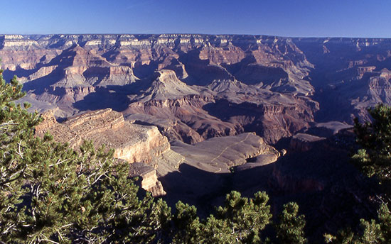 Plateau Point from Bright Angel Trailhead. |
|
We started down the Bright Angel trail on a clear, crisp, sunny morning and wound slowly down the switchbacks, plunging into the Bright Angel Canyon. We passed some mountain goats right by the first arch, then continued down the trail through 2 billion years’ worth of rock layers. |
 Redwall Limestone on the approach to Indian Garden. |
 Canyon view from about a mile below the trailhead. 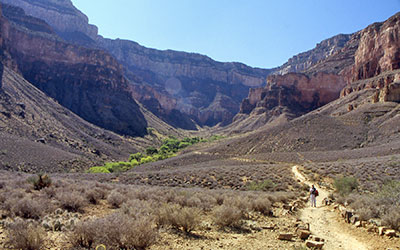 Sharon stops along the trail for the view of Indian Garden. |
Sam was kind enough to wait for me as I proceeded slowly down the switchbacks, eventually resorting to using my knee brace. I was busy snapping pictures and was totally impressed by the straight horizontal seams separating the rock layers. The nicest thing about the trail was that it was in maintenance mode so that there were no mule trains, as well as the conveniences of bathrooms and fresh water every 1.5 miles. In addition, most of the trail was in the shade, both on the way down and back up. I kept taking the same pictures over and over again, but at different elevations, because the view was so spectacular. It is a humbling and breathtaking experience to be a part of such grandeur, and I was thrilled to have the opportunity to hike the canyon for the first time. |
|
We descended down through layers of Kaibab Limestone, the Toroweap Formation, and Coconino Sandstone, all light in color, then down into the red rock layers of Hermit Shale, the Supai Group, and Redwall Limestone. We were in the side canyon the whole way down, with rock walls towering above us on three sides, with a crescent moon on top. We plunged further into the Muav Limestone and Bright Angel Shale formations. All of a sudden, the trail became flatter and there were a lot of cottonwood trees. A group of us rested in the cool shade at Indian Garden and consumed snacks before proceeding out to Plateau Point in the 90-degree sunshine. We were rewarded there by a view of the Colorado River roaring over rapids below. |
 The Colorado River from Plateau Point. 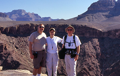 Joe, Sharon, and Chuck at Plateau Point. |
|
I had goosebumps on the way back to Indian Garden, overwhelmed by the magnificence of the rock layers before me. Upon my return there, I met Joe Michalides, and we both refreshed ourselves by dipping our feet in the creek. We then began the long ascent to the top. It was rather discouraging when Ryan went running past me and Tim went speeding past, but the rest of us just kept up our steady pace and met at the rest stops. After a while, I stopped looking up because the rock walls were still so far above me. Eventually, everyone made it out in one piece. |
 Sharon at the point, with the Colorado River below. |
 Powell Memorial, at Powell Point along the West Rim Trail. |
Photos by Chuck Parsons. |
 Top of Page
Arizona Trailblazers Hiking Club, Phoenix, Arizona
Comments? Send them to the AZHC .
updated August 27, 2018