Outdoor Links
Hike Arizona
Trip Planning Guide
Trip Report Index
Calendar of Events
Library
|
Journey into the Canyon Grand Canyon National Park October 18-21, 1997 by Jeannie Van Lew |
|
|
Saturday, October 18, 1997
I wake early and cold. At first light everyone begins to stir. We discuss the merits of taking tents, while thinking about a warm breakfast. We worry about Lynn and her truck. Soon we find out that she has decided to call for a tow truck. It will take her truck to Flagstaff for repair. Now she can join us on the hike. By 9:00 the tow truck arrives. We pack up the cars and head over to Yaqui Point after a short stop at the general store. After arriving at the trailhead, we stretch and adjust our packs for the seven mile (and heaven knows how many hours) hike that is ahead of us. The Park Service constructed the South Kaibab Trail to provide tourists with a free access path to the river. At the time, a toll was charged to use the Bright Angel Trail. Ah! We step onto the trail! We are actually IN the Grand Canyon! Down, down, down we go. Past a mule train. Walking over and around mule dung. The pack begins to feel as if it’s cutting into my neck and shoulders. Jon and Adrienne are ahead of Tom and me and the distance between us grows and grows. Soon they are out of sight. I am comforted with the knowledge that they each have their own water, however, I am carrying everyone’s lunch. The miles pass slowly. The South Kaibab Trail is one of the few trails in the park that follows the ridgelines and therefore is VERY steep. We have walked past the Kaibab Limestone, Toroweap Foundation and Coconino Sandstone to Hermit Shale. We push on, back and forth, back and forth, switchback after switchback. We wait for another mule train to pass by us. We exchange greetings. |

|
We finally catch sight of the kids, resting at Cedar Ridge. A whistle brings waves from them. A long final downhill slope covered with loose gravel and dirt and we’re there. We’ve only gone 1.5 miles and back in time 286 million years. When we catch up to the group, we take off our packs and our boots for a much-appreciated break and enjoy a spectacular view of O’Neil Butte. I wiggle my toes and check the moleskin on my bunions. |
|
We have a quick lunch of meat and cheese on a tortilla, a hard-boiled egg and wash
it all down with some Gatorade.
We are back on the trail, moving on, awestruck at the indescribable scenery. We all hike together for the time being. We are now on the east side of Cedar Ridge where it “flattens out” a bit. Jon is having a problem with his pack and shorts – funny thing about clothes that don’t really fit. As we start rounding O’Neil Butte, Surprise! We can see the most incredibly steep set of switchbacks before us. We have passed through the Supai Formation (286 to 320 million years old) and the switchbacks take us down through the Redwall Limestone (320 to 360 million years old). I am growing tired of going downhill. I use my hiking stick continuously. The restroom at the Tipoff comes into view and we watch Jon jog down the hill towards it. Machell and Debby are already there resting. Soon they radio that Jon arrived O.K. We pass the Tonto Trail on the Tonto Plateau ... we are there. Off go the boots again and we replenish fluids with Gatorade. Lynn catches up to us as we all have a short rest. Back on the trail, we’ve gone 4.4 miles. We (Tom, Jon, Adrienne, Lynn, Machell, Debby and me) stop one more time, at Panorama Point. From the “point” we are about two miles or so from Bright Angel Campground and we catch a great view of the Colorado River and the inner gorge. It is AWESOME! |
| Switchbacks again are before us. I am REALLY getting tired of going down now. I try the “speed walker” walk and swish the hips, locking the knees, but only during relatively flat areas. It seems to help some. We sing and tell jokes. We are walking through the Tonto Group (505 to 570 million years old), the Tapeats Sandstone and the Vishnu Schist, which dates back two billion years. (Is that how long we have been walking???) |

|
|
I have heard of hikers growing so tired of hiking downhill that they turn and
walk backwards. I wonder if that will really work?
We hear from Scott and Sylvia who are behind us yet. They have just encountered a big horn sheep. A streak of envy shoots through me. We then hear from Dawn and Angela who are almost to the Black Bridge. The rangers say that the mules will not cross over the Silver Bridge. They don’t care to look down through the grates, so they cross over on the Black Bridge. Rubber matting covers the Black Bridge blocking the view of the rushing water from the mules as they cross it. |
|
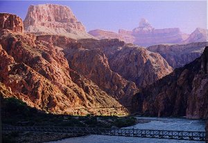
Jon and Adrienne forge ahead of us and before we know it we see them on the Black Bridge waving up to us. We come to a fork to the left leading to the River Trail. It runs along this side of the river and leads to the Silver Bridge. We go through the tunnel and across the bridge and begin our final leg of the journey. We pass by an Anasazi Ruin. Only the foundation of some buildings and some old stone tools remain. The Anasazi were the ancestors of the Hopi and other modern Pueblo Indians. |
|
We have heard from Dawn and Angie, they are at camp. We pass the camp on
one side of the creek, Adrienne and Jon yell across the creek that the bridge
is just up the trail a bit. When we arrive at camp, the kids have laid claim
to our “space” and are setting up their sleeping bags. The campsite
consists of a spacious dirt floor, picnic tables, a 6' high packbar from
which to hang our packs to keep them from critters, plus trees and a river
and a canyon and a creek named Bright Angel.
I crank up the cookstove and make dinner of Ramen noodles and homemade dehydrated hamburger. Not bad. After cleaning up the dishes and rinsing at the outside sink, we return to camp where we spot a ring tail scampering across the bar where we had hung our packs. So much for keeping them away from the animals. Scott and Sylvia arrive at camp. They are going up to the canteen for a beer and invite Tom and me to join them. We decline, the thought of walking another 0.3 miles did not sound like something we wanted to do, Tom’s knee is really hurting him. Here we are spending our first night in the canyon. I lie there all snugly warm looking up the awesome stars. A shooting star flashed across the night sky. Now I can sleep. Morning seems to come early. Wait – it’s only 3 AM, the bright light in my face is the moon, not the sun! The light floods the area and casts a whitish glow and shadows everywhere. Bright Angel Creek rushes by our site with a rumble. My legs are stiff as I make a 3 AM run to the restroom. I have the famous “Kaibab Shuffle,” but surprisingly my knee is not as swollen and sore as I expected. Sunday, October 19, 1997 We rose to a beautiful morning. The sky was clear, the air had a hint of coolness, the stream continued to babble nearby and the birds were singing in the trees. Breakfast consisted of instant oatmeal and Tang. There was some discussion about the 13-mile hike to Ribbon Falls. Tom and I decide we are unwilling to hike that far, and to our surprise, no one else is either. So, Tom, Adrienne, Jon, Sylvia and I walk (or shuffle) down to the Phantom Ranch Canteen. There we purchase our keepsakes and the best ice-cold lemonade in the Canyon! We sent post cards that were postmarked “mailed by mule from Phantom Ranch”. We sat outside, enjoying our lemonade and a cool breeze. 
|
| Once on the bridge, however, Tom’s knee was really bothering him. We decide not to continue since the River Trail ended going down the same switchbacks to the Black Bridge we had done the day before. Jon, however, took off to catch up to Dawn and Angie. Tom, Adrienne, Debby and I go down by the river and wiggle our toes in the Colorado River. That is one COLD, fast moving river. |

|
|
Back at camp we lunch on tuna and bagels. Adrienne and Tom crash on their
beds. Jon tries to talk me into doing the River Trail with him again.
I felt it was a good idea to keep my legs moving, no matter how tired or
stiff I was, but I was not ready to do anymore down hill walks. I persuade
him to go up the North Kaibab Trail instead. The North Kaibab Trail, after
passing Phantom Ranch, follows the creek almost to the top of the North
Rim and is relatively flat. We return in time for the 4:00 Ranger
presentation on the Canyon flora and fauna.
After the presentation we returned to camp to begin dinner preparations. Nightfall comes quickly at the bottom of the canyon and I didn’t want to be cleaning up in the dark again. We returned to Phantom Ranch for the 7:30 Ranger presentation, which included two interpretations of the forming of the Grand Canyon. The first was the geologic story and involved audience participation. The second was the Hopi legend of two lovers and the story of good versus evil. Afterwards we stopped in to the canteen for a glass of wine, beer and a couple of lemonades for the kids. The wine should help me sleep tonight. Monday, October 20, 1997 We left the Bright Angel Campground around 8:30, in small separate groups. Scott had everyone switch the batteries on their radios. After crossing the Silver Bridge we head west for another mile or so and are actually hiking along the River Trail. The trail remained level, more or less, and at first, we spent a lot of time walking through sand. Finally, Bright Angel Trail broke off to the left (south). The Bright Angel Trail was originally an Indian trail used by the Havasupai Indians to commute between the rim and Indian Gardens. Prospectors improved the trail in the late 1800s. One of the miners, Ralph Cameron, realized that the tourist trade was more profitable than the mining trade so he bought out his partners and took control of the trail. He extended the trail from Indian Gardens to the river and began to charge a toll of $1 for its use. Once we started UP the trail, we entered a whole new world! The trail follows Garden Creek that flows from the South Rim, running through its own little “mini” canyon within the Grand Canyon – Garden Creek Canyon. We lost sight of the Colorado River pretty quickly and also of Adrienne. Bright Angel Trail was so green, the canyon was filled with Cottonwood and Sycamore trees for miles of the trail, which crosses over Garden Creek several times. We then came to the little falls that is just before the Devil’s Corkscrew. This section is named for its resemblance to a corkscrew when viewed from above. The reference to the Devil is because of the terrible heat that can be encountered along this stretch of trail during the middle parts of the day. In the summertime it is not uncommon for the temperature to reach or exceed 130 degrees F. I’m glad we’re here in October, we couldn’t have asked for better weather! There are some nice little falls and cascades along Garden Creek right at the top of the corkscrew section. Right after which the creek makes a nose-dive to the falls that we had passed below. |

|
We hear Jon is already at camp, it is 11:00. We caught up to Adrienne who
was with Debby and Machell at a shady spot along the creek. We took off
our boots and cooled our feet in the stream. Dawn and Angela got to camp
about 12:00. We got there around 2:00. Upon entering the campground we
spotted a deer feeding on the hedge beside the trail. We made camp, which
consisted of laying out our ground cloths, pads and sleeping bags.
Jon entertained everyone while he played hackysack.
That evening, we hiked out to see the sunset at Plateau Point. After which we enjoyed dinner in the dark followed by Jiffy Pop and lively conversation around the – umm – flashlights. Lights out came quickly. I did waken once during the night to the sounds of a deer feeding on the other side of the hedge from us. |
|
I looked at him, he looked at me while our eyes locked for a long moment.
Then he went back to feeding and I went back to sleep.
Tuesday, October 21, 1997 I wake early. We have 3200 ft elevation change to look forward to today. We get underway around 8:30. The trail starts out relatively flat for a half mile or so. We begin meeting people coming down from the top who are fresh and clean smelling. We then start up a tiring series of switchbacks known as Jacob’s Ladder. We meet others going up and we pass and re-pass one another. At three mile rest house we stop and take off our packs. The sensation of almost floating overcomes me. I wander behind the rest house where I get a grand view of the canyon below. I find the remains of the old cable car system that used to bring supplies down to Indian Gardens. At mile and a half rest house we stop for another snack We’ve only gone a mile and a half??? We need to fix Jon’s backpack. The strap attaching the hip belt to the frame broke and he has been carrying the weight of the pack on his shoulders. Once he is fixed he takes off to catch up to Adrienne who is now a steady hiking partner with Machell and Debby. We talk to a nice couple from Wales ... Time to go! We pass 2 mile corner and find the petroglyphs left in blood by the Indians. I welcome the rest. I am beginning to feel I have less spring in my step. It wouldn’t be so bad if I weren’t lugging this pack and if I weren’t going uphill. There’s only two miles left to go, I walk that every morning, piece of cake!! 
Sometimes I wondered how we were going to get over that “blankety blank” cliff that was overhanging us. But then I would look at where we had come from. We could see the trail descend do Indian Gardens below us. What a view. We saw many people, some of whom only carried their cameras and 32 oz water bottles and had the audacity to think that I, a backpacker going uphill with a 35 pound pack, should stand to the side while he or she, the tourist going downhill, RAN down! We hear again from Adrienne and Jon, they are at the top. It’s not much farther now. We meet a family from Turkey with a small child. They are not carrying any water. The boy is already shivering from the cold breeze. They take our advice and turn around and return to the top. We stop at the second tunnel (no one told me there were TWO tunnels, after the first I thought we were almost home!) to view the petroglyphs thought to be left by the ancient Anasazi. We overhear someone talking about sheep over the edge. There they are – a ram, a momma and a baby big horned sheep. I stop to watch and take a few photos. Just one more corner ... just a few more steps ... there’s the sign marking the trailhead. After five hours and 30 minutes, we have reached the rim! Jon and Adrienne, already rested, want to go to the store and get T-shirts and ice cream. Tom has made a beeline to the porta-john. I just want to get this pack off my back. I found Debby and we hiked the 1/2 mile to our truck so I drive her to her car. Once we finally reached the truck parked at the Maswick Transportation Center, I see “the Club” locked on the steering wheel. You should have seen the look on our faces when we realized I didn’t have the key! We scramble to find money and the phone number to the bar where Dawn was last known to be. She arrives and after a lengthy search I locate my purse and the blessed keys! Debby and I get her car and return to the group that has assembled near Tom. Finally we are packed up and heading home. The Canyon is an awesome place, and one of the very special experiences in life is to experience it by hiking through it! Hiking the Grand Canyon was an amazing experience. One cannot see what the Grand Canyon looking at it just from the top. |
 Top of Page
Arizona Trailblazers Hiking Club, Phoenix, Arizona
Comments? Send them to the AZHC .
updated June 21, 2020