Outdoor Links
Hike Arizona
Trip Planning Guide
Trip Report Index
Calendar of Events
Library
Hiking in the Spectacular Wilderness of Rocks
September 20-22, 2002
by Chuck Parsons
|
Angie Lien and I were the first of eight MHC campers to arrive at Rose Canyon Campground, situated at 7,200 feet in the tall pines of the Santa Catalina Mountains north of Tucson. We set up camp and cut wood for the night’s fire (fire restrictions lifted at last!) and were in the process of getting ready for dinner, when Joe Michalides and Michael Humphrey arrived. |
 The serpentine Catalina Highway snakes its way up the Santa Catalinas. |
|
It was almost dark by the time Rudy Arredondo and Jo Macias arrived, and the temperature was dropping fast as the night chill of the Catalinas started to set in. It actually felt pretty darned good to be this cool for a change to us heat-weary desert dwellers, by now sick of seeing daily triple digits in the forecast. Time to break out the long-sleeve shirts and sweatshirts. Our resident fire tender, Angie, was now busy getting the evening’s campfire going. This gal really knows her stuff when it comes to preparing a campfire, and in no time at all we had a nice crackling fire going, as we all gathered around to warm up a bit after dinner. The night skies begin to fill with twinkling stars (where are you, Joe Orman?) over the Catalinas, and before long the almost full (that would come the following night) harvest moon began to crest over the ridge behind our campsite. Within a few minutes the moon revealed its full bright sphere through the jagged tree line on the ridge. What a fantastic sight this was. We knew Richard DeSouza and his wife Rochelle Mascarenhas were not expecting to arrive until around 9:00 PM and were beginning to become concerned when they still had not arrived by 9:30. It would be almost 10:00 before they finally rolled into camp. All were at last present and accounted for, as the evening wore on. We had a long day ahead of us tomorrow, as we slowly begin to turn in for the night. Saturday morning greeted us with crystal clear, pale blue skies and a crisp, cool 45 degrees. It is hard to believe that the hot, burning deserts of Tucson lie just 25 short miles below us, down the winding Catalina Highway. We begin to prepare hearty breakfasts of bacon, eggs, bagels, and pancakes that would fuel the day’s hike. |
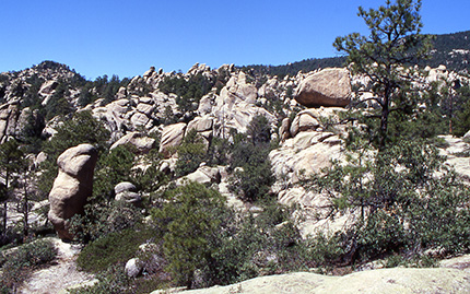
 Wilderness of Rocks — a geological wonderland. |
|
Our destination today would be the Wilderness of Rocks, a geological wonderland of rugged and weathered granite formations standing as massive sentinels watching over the southern slopes of Mt. Lemmon. Breakfast finished and the camp secured, we pile into two vehicles and head for the summit of Mt. Lemmon and our trailhead for today’s hike. Just before the picturesque village of Summerhaven, we make a right turn at the signed turn off to Ski Valley and continue winding up the narrow paved road until it comes to a dead end by a large fenced communication towers complex near the top of the mountain. Studying the official trailhead sign, we soon realize this hike is going to be a bit longer than originally planned, since the full loop is actually exactly nine miles, instead of eight, as shown in my reference book. It is just past 9:30 AM, as we start our descent to the Wilderness of Rocks on the Lemmon Rock Lookout Trail just below the 9,157-foot summit of Mt. Lemmon. |
 Rochelle, Richard, Michael, Rudy (kneeling), Joe, Angie, and Jo gather at the Lemmon Rock Lookout Trailhead. |
|
We start hiking in a forest of towering Ponderosa pine and Douglas fir, some up to four feet in diameter and sixty feet tall. Colorful Indian paintbrush, lupine, and fleabane dot the trailside from time to time. Despite the 18 inches of rainfall these mountain slopes have seen since early July and the start of the Arizona monsoon season, it is still not sufficient to overcome Arizona’s prolonged drought and populate the forest and meadows with the normal profusion of wildflowers seen throughout the summer months. |
|
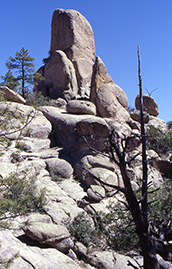
We soon come to a short spur trail that takes us up to Lemmon Rock, a craggy granite outcropping with a small white building perched on its very edge. We use this opportunity to take in the spectacular surroundings and get a few more pictures, including another group shot. We next encounter a series of short switchbacks, as the trail snakes its way down Mt. Lemmon to the junction with the Wilderness of Rocks Trail. Parts of this trail literally sparkle in the diffused sunlight filtering down through the overhead canopy, as light reflects from ground up bits of mica and feldspar. Pieces of broken quartz also start to litter the trail, before becoming fairly common as we drop in altitude. We traverse through the last of the switchbacks, before making a couple of dry creek crossings and decide to take a short rest break among some large granite boulders scattered on the forest floor. Checking our watches, we realize that we are not making very good time to this point, and are going to have to start moving faster if we hope to complete the nine-mile loop before sunset. We hit the trail again, determined to make better time. |
 Great view of the Santa Catalinas from the upper trail. |
|
Another half mile of so and we come to the Wilderness of Rocks Trail junction, which will now take us in a southwesterly direction. We have dropped over a thousand feet to this point, and our forest cover of pines and firs has gradually given way to Arizona white oak, silverleaf oak, Arizona madrone, and even a few alligator juniper. Our more open trail and southern exposure even allow for the occasional prickly pear cactus and yucca, despite our still relatively high elevation. |
 One of many horny toads we meet along the trail. |
|
We spot the first of several baby horny toads scurrying across the trail. These little guys (about one inch long) blend in so well with the trail you cannot see them until they start moving, so we carefully step around them, as they go about their business. |
|
Before we even realize it, we have already entered the fantasyland maze of giant rock formations known as the Wilderness of Rocks. Carved and sculpted over the millennium by the ongoing and relentless forces of wind and water, the eroded and weathered granite monoliths become more and more spectacular as we penetrate deeper and deeper into this rock wilderness. As far as the eye can see, domes, pinnacles, pillars, columns, hoodoos, and balanced rocks rise out of the forested slopes of Mt. Lemmon and reach for the brilliantly clear blue Arizona sky. The contrast of forest, rock, and deep blue sky is nothing short of breathtaking. It is easy to lose track of time here, as I start wondering off the trail in search of that perfect picture to capture the unique essence of this rocky wonderland. It is almost noon, as we take a lunch break near the junction with the Mt. Lemmon Trail that will return us to the summit and our trailhead. |
 You’ll have to use your imagination here. |
|
|
| Interesting rock formations along the Wilderness of Rocks Trail. | |
|
At this mid-point in our loop trail, we have dropped over 2,000 feet in elevation and face a long and rigorous 4.5-mile climb back to the top of Mt. Lemmon. The full Mt. Lemmon Trail actually descends 3,450 feet from the summit to Romero Pass, a total distance of 6.3 miles. Compared to that, our 2,000-foot climb doesn’t seem so bad after all. To the southwest and southeast lie the numerous canyons that form the drainage network for Mt. Lemmon, including Romero, Lemmon, Sabino, Box Camp, Spencer, and Pine. In the distance we can see the faint outline of the Mt. Lemmon Trail, as it follows a jagged ridgeline back to the summit. We start a steady ascent through the rocks and boulders that form the southwestern end of the Wilderness of Rocks. Live oak and manzanita grow in profusion from any fissure they can take root in. |
 Small pools of water remain after recent rains in the Catalinas. |
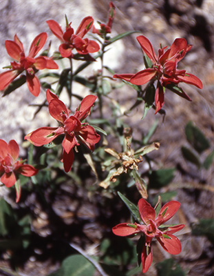 Indian Paintbrush Steadily ascending the ridgeline, we are refreshed by the cooling breezes blowing in from the west, as our path takes us through a lush undergrowth of waist-high ferns, growing in abundance from the monsoon rains. At the Sutherland Trail junction, 1.5 miles from the summit, the trail transitions to an old abandoned road bed, which, despite being wider, proves to be no easier a hike as it relentlessly claws its way to the top through a dense forest of pine, fir, and scattered aspen groves. The temperature drops steadily as we near the summit. By 5:30 we are all back at the trailhead and ready to head back to camp and dinner. Rudy and Jo have already left by the time we return to spend some time with her folks in Oracle. After washing off the trail dust of the day, we settle down to a great potluck dinner of salad, chili, burgers and hot dogs, chips and salsa, and cantaloupe, all washed down by cold soda and beer. Angie has a nice roaring campfire going for us once again, as we gather in a circle around its welcoming warmth and watch the full harvest moon rise over the ridgeline behind our camp. We have just enough mulberry wood left to fuel the fire for a couple of hours, until we all begin to tire from the long day’s hike and start to retire to our tents for the night. |
 Hopeful anglers try their luck at Rose Canyon Lake. |
|
We wake early Sunday morning to the raucous call of the Raven, as it cawed and flew on noisily beating wings from tree to tree around our camp. After breakfast, we break up camp and head over for a quick look at Rose Canyon Lake at the end of the campground road, just in time to see several fishermen reeling in fat, squirming rainbow trout. A few of us decide to take a tour of Summerhaven and stop for refreshments and a look at one of the gift shops, where I purchase some home-made maple/walnut fudge. We then stop at Lookout Point, where Angie and I finish off our last rolls of film on the unique granite formations and scenic overlooks, capturing a couple of rock climbers descending a sheer cliff face. With that, we all head back down the winding Catalina Highway into Tucson and back to the Phoenix area, hopefully to return once again next year to hike and camp in this beautiful Sky Island, known as the Santa Catalinas. |
 Angie, rock climbing. |
 Top of Page
Arizona Trailblazers Hiking Club, Phoenix, Arizona
Comments? Send them to the AZHC .
updated June 24, 2020