Outdoor Links
Hike Arizona
Trip Planning Guide
Trip Report Index
Calendar of Events
Library
Sedona
May 1, 2004
by Chuck Parsons
 Rudy, Michael, Joe, Barry, Shari, Misti, Joyce, Joe, Kathleen, and Dave at the trailhead. |
|
If you drive Interstate 17 even on an irregular basis, it is inevitable that you are going to be involved in a major traffic backup sooner or later. Sooner or later comes on the morning of Saturday, May 1, as our four vehicle caravan gets bogged down in a five-mile backup on I-17 near Cordes Junction. Two lanes of northbound traffic are slowed to a snail’s pace for as far as the eye can see, while the southbound traffic flows at its normal pace of 75+ MPH. Southbound drivers are no doubt feeling very fortunate they are not going in the opposite direction this morning. We Trailblazers (Chuck Parsons, Joe Orman, Kathleen Green, Rudy Arredondo, Joyce Parrish, Shari Kay, Joe Michalides, Barry Altschuler, Michael Humphrey, Dave Self, and Misti Mobley) keep in touch via our Motorola TalkAbout radios, as we assess the traffic progress. After about a 45-minute delay, we finally approach the accident scene and see the flashing lights of Highway Patrol vehicles, ambulances, and fire trucks on the scene. A large travel trailer lays on its side off the side of the highway, with its aluminum siding shredded and tattered, exposed to the elements. Once past the accident scene, traffic slowly resumes its normal pace, and we finally make it to the Highway 179 turnoff to Sedona. We soon arrive at the South Gateway Visitor Center in Tequa Plaza on the west side of 179 and re-group there to purchase our Red Rock Passes. From the “Y” intersection of 179 and 89A in Sedona we head west for three miles on 89A to Dry Creek Road. We then head north and proceed for a couple more miles to Vultee Arch Road, where we make a right turn and head northeast for another 1.3 miles to the Devil’s Bridge Trailhead. It soon becomes obvious that this stretch of forest road has not been graded in some time, as we bounce along on deep ruts and major washboard to the trailhead. Because it is already so late in the morning (almost 10:30 AM) the limited trailhead parking is already filled up, and some of us are forced to drive ahead and park off the side of the road wherever we can find space. We assemble for our customary group picture at the 4,600' trailhead and begin hiking under clear blue skies, with a refreshingly cool breeze and a perfect temperature of 75 degrees. We are getting a rather late start, but only have 0.8 miles of hiking to reach our destination, so we are in pretty good shape time wise. The first half-mile of the trail is fairly wide and level, as it follows an abandoned jeep trail through the high desert forests of pine, juniper, oak, and beautiful flowering manzanita, typical of the Red Rock Secret Mountain Wilderness area north of Sedona. After the half-mile point, the trail begins to gradually climb and gets progressively steeper, as we near the bridge – or shall we say arch. Since it does not actually span a streambed and was not created by the carving action of water, Devil’s Bridge is not a true natural bridge, but in reality an arch. About three-quarters of a mile in, we come to a fork in the trail and must make a decision to approach the bridge from either the left side or the right side. |
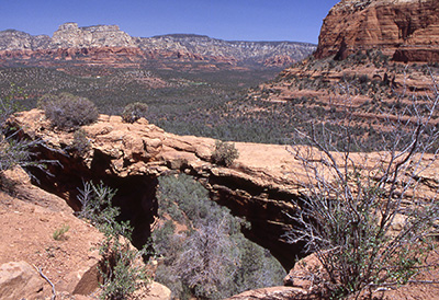 Devil’s Bridge |
Our group actually decides to split up at this point, with about half approaching from each side. I join the group making the approach from the left side, as we hike through a wash area and some brush, then along a narrow rock ledge, before emerging directly under the bridge about fifty feet overhead. |
|
We then have to scramble up a loose rocky slope and pull ourselves up with the aid of hand holds in the rock and tree roots, before finally coming to a path that will lead us to the very top of the bridge. The second group takes a bit easier route up a steep, natural rock staircase that the Forest Service has improved with the generous use of large sandstone slabs. We all regroup near the top of the bridge, where we take turns walking across the bridge and taking pictures of one another. This 4,900' vantage point from the top of Devil’s Bridge also provides outstanding panoramic views of salmon and cream colored cliffs and buttes overlooking the surrounding emerald green forests of the Secret Mountain Wilderness area. Some of us hike above the bridge for one last picture of the bridge and surrounding area. We all opt for the natural rock staircase, as we begin our descent and head back to the trailhead. Once back at the trailhead, we make a group decision to drive to the Vultee Arch Trailhead, before we stop for a lunch and rest break. Although only another three miles north on Vultee Arch Road, the drive takes us longer than expected, since this stretch of forest road is the roughest yet, with major washboard sections, large ruts and potholes, and the occasional large rock to avoid. Joe Orman and I are having a tough enough time rocking along in my Dodge Dakota pickup, so we can only imagine what the smaller passenger cars are going through. Kidneys and bladders now going into overtime, we bump and bang along over the washboard until we finally come to the end of the road at the Vultee Arch Trailhead, where we park under the ample shade of large sycamore and juniper trees. The time is now 12:45 PM, as we dig out lunches and snacks and sit in the shade, most of us using a large fallen ponderosa pine as a long bench seat. Kathleen lies back on her own private log for a short nap. Between the deep shade and the cooling breeze that has stayed with us most of the day so far, we quickly cool off to the point of almost needing another layer for at least a while. Lunch over with, it is time to hit the trail once again to get the blood circulating and warm up a bit. Starting from an elevation of 4,800', the Vultee Arch Trail gradually gains 400' of elevation in 1.7 miles, as it moves in an eastward direction, before reaching its destination. We enter the Red Rock Secret Mountain Wilderness Area after about 100 yards of hiking, as the trail traverses along the gently sloping floor of Sterling Canyon. Although it is not that warm today, we still welcome the cover of shade provided by thick stands of alligator juniper, Arizona cypress, and Gambel oak. We cross a normally dry wash with deep-rooted and sprawling sycamore and cottonwood trees that are testimony to the large volumes of water that can flow through here during spring runoff and after heavy summer monsoon rains. The shadier south side of Sterling Canyon, as opposed to the sunnier and more arid north side, supports heavy stands of Douglas fir and ponderosa pine, providing an even greater cover of shade as we move further east. We cross the dry wash a few more times, as we notice occasional clusters of large sweet-smelling yellow-orange flowers, known as Western Wallflowers (thanks to Kathleen for the botanical ID), swaying in the cooling breeze on impressive two to three-foot tall stalks. At 1.5 miles from the trailhead, we come to a signed junction with the Sterling Pass Trail, which forks to the right and takes the hiker all the way to the head of Sterling Canyon and then Sterling Pass, before finally terminating at the rushing waters of Oak Creek. We continue going straight at the junction for another 0.2 of a mile, as we follow the rock cairns, and break out into a clearing near the base of a large slickrock bench bearing a bronze plaque. |
|
Caught up in an unexpected snow storm on a cold January night in 1938, aviation pioneer and head of Vultee Aircraft Corporation, Gerard Vultee, along with his wife, Sylvia, lost control of his personal Stinson aircraft and crashed in an area known as East Pocket, about one mile north of this bare redrock bench that now bears a large bronze plaque commemorating the two. |
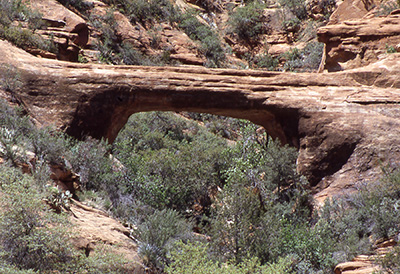 Vultee Arch |
|
Named after the Vultees, who were both killed instantly in the 1938 crash, Vultee Arch stands like a massive lone sentinel against the far north wall of Sterling Canyon, as if guarding the crash site against all intruders. Surrounded by thick, heavy brush, the arch is well protected and virtually inaccessible to all but the most persistent and serious bushwhackers. Since none of us are quite that persistent or serious about bushwhacking on this beautiful spring afternoon in May (sorry, Ted Tenny), we spread out on the slickrock bench to rest and admire the imposing sandstone arch, with its 40-foot span, as well as the awesome grand vistas looking west through Sterling Canyon, with its sheer redrock cliffs, spires, and ridges – all surrounded by thick emerald-green forests of ponderosa pine, Douglas fir, oak, and juniper. This is a classic Arizona Highways view, and our cameras fire away, as we savor the sights and enjoy the moment of this very special place in red rock country. As much as we would like to stay longer and enjoy the views, the afternoon grows shorter and we decide to start the hike back to the trailhead. We return along the same route, arriving back at our vehicles by 3:15 PM. We could not have asked for a more perfect day for hiking, with the temperature never rising above 75 degrees in the shade, a cobalt blue sky overhead all day long, and a refreshingly cool breeze accompanying us for most of the hike to Vultee Arch and back. We brush off the day’s trail dust, put away our gear, say our good-byes to one another, and head back down the bumpy and rutted Vultee Arch Road, leaving the spectacular red rock country of Sedona and the Secret Mountain Wilderness behind us – but only for a while. We will all be back one day soon. |
 Top of Page
Arizona Trailblazers Hiking Club, Phoenix, Arizona
Comments? Send them to the AZHC .
updated September 4, 2017